

Matthew70
-
Posts
624 -
Joined
-
Last visited
Content Type
Profiles
Blogs
Forums
American Weather
Media Demo
Store
Gallery
Posts posted by Matthew70
-
-
9 minutes ago, MUWX said:
Not sure, just saying that it’s a size able step back from a large 90% to and very small 75%.
This is at a later hour. Plus the higher % moved into TN at that hour. So wether it’s 90% or 75%. Still do not like that being in my backyard. No thank you please. My brother is just now having his house rebuilt.
-
Surprised no one is talking about possible threat of severe wx
-
 1
1
-
-
He means more severe wx. Trouble for Dixie alley and Jeff not rooting for it says a lot. I will pass please. I am definitely looking into getting a storm shelter.
-
1
-
-
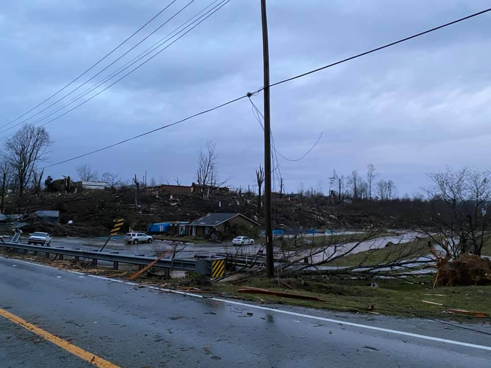
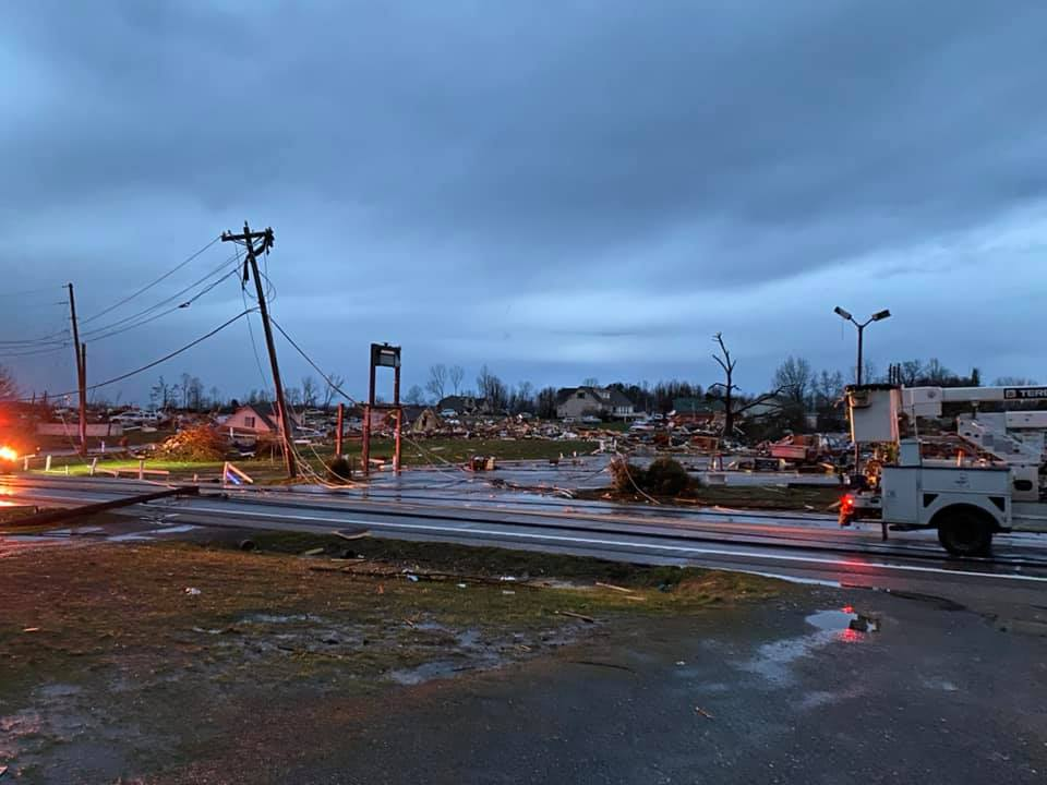
Cookeville search only completed 30%. Morgue setup. Expecting more deaths. Per family member involved.
-
 1
1
-
-
Have been notified by family in Cookeville in search that a temporary morgue is being set up. Bodies still being recovered of whole families. Estimated around 30 alone have passed in Cookeville.
-
1
-
-
This is near my sister’s house in Cookeville
-
My family is safe but my brother lost his house and my mom has damage in Lebanon. My sis is 4 miles from devastation and knows several who have passed in Cookeville.
-
6
-
-
Thing is no one knows if this virus will stop like the flu in warmer temps. Some reports I have read it will not. I believe it is a bio weapon that has accidentally been released. Plus it keeps mutating. I am ready for warmer temps and dryer conditions away. Amazing that we have had such odd winters last few years.
-
3
-
 1
1
-
-
28 minutes ago, Carvers Gap said:
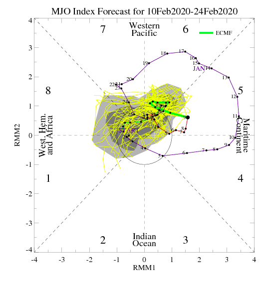
These are fairly significant trends in the ECMF MJO as it almost makes it into phase 8. At this point, the MJO is beginning to hint at a large scale pattern change and not just a window of opportunity. JUST using the ECMF MJO(there is another version ECMM which is slightly less bullish which uses climatology...ECMF is just the pure ensemble run I "think"). This actually has support from both the GEFS which is likely overly amped, but headed in the same direction. It also lends support to what John was saying earlier in the thread that once the MJO hits phase seven, it gets cold after that w a lag possibly built in. So, the signal for cold during week 4 of February is now a bit stronger IMHO. Let's see if it holds and trends even better. The GEFS has been sort of correct in the higher amplitude of 5, but seems out there with high amplitude 6/7. So, a mini-victory for the GEFS up to this point. Either way, both the ECMF and GEFS are heading towards better phases in about ten days or sooner. That is also supported by ensemble runs hinting at changes. Always good to be aware that sometimes modeling can jump the gun....but thought this was worth a share. If true, this would likely provide us with a potential window of more than just 2-3 days but counterweighted by climatology being less favorable by the day at that timeframe. Good news to see modeling hustling out of "bad" phases of the MJO.
Just hope this does not mean a cold rainy spring.
-
1
-
-
5 hours ago, PowellVolz said:
Cool season grass?
.Fescue
-
1
-
-
1 hour ago, PowellVolz said:
I mowed 3 days ago. Pic from my IG of me mowing on Christmas Eve. It’s still growing and I’ll probably put down preemerg this week.
.I was thinking on fertilizer tomorrow also? Thinking can’t hurt and not to early right?
-
I want to say thank you to all of you for all the useful info and thoughts about the models and winter chances. This is the best wx blog hands down. I can’t stomach the Southeastwx board anymore. Living off every model run and immature comments. Keep the great input coming.
-
5
-
-
‘Smoke-nado’ Spawned by Kentucky Fire
https://www.weather.com/news/trending/video/smoke-nado-swirls-in-southern-kentucky-fire?pl=pl-the-latest
From The Weather Channel iPhone AppJames Spann
Yesterday Alabama had 19 wildfires statewide, bringing the total to 156 in the last 7 days and 313 in the last 30 days.We can expect more fire starts, hotter, faster fires, and erratic fire behavior in the dry air over Alabama. It is also harder to get containment lines to hold the fire when humidity is low. Be very careful if you have to do any outdoor burning!
These dry conditions are setting the southeast up for lots of dangerous times if it persists. I live next to woods.
-
2
-
-
6 hours ago, TellicoWx said:
By no means am I saying this is how it will play out, but it is a little unnerving the date of the analogs on the 18z NAM. April 1998 was the F5 in Davidson Co.

The EF5 was in Lawrence County. Only one ever in TN (I think). Also known as the forgotten one. The Nashville one was EF2/3.
I am thinking the Nam is way off. We shall see.
-
Only one word needs to be said to reason not getting snow.....
TENNESSEE
-
 1
1
-

April 12 Severe Threat
in Tennessee Valley
Posted
So really no reason to worry here in mid TN? Just possibly high winds and lots of rain?