
Matthew70
-
Posts
647 -
Joined
-
Last visited
Content Type
Profiles
Blogs
Forums
American Weather
Media Demo
Store
Gallery
Posts posted by Matthew70
-
-
6 hours ago, Carvers Gap said:
IMHO, the total precip map(to date)above looks remarkably like Nino precip pattern maps, BUT displaced about 200-400 miles eastward. I think I mentioned several months ago that modeling was signaling very dry weather for the middle and western portions of the forum...and that eastern areas should see more rain chance. Right now, all of that is displaced eastward towards the EC. The problem with drought is that it when it persists...it "calls" for more drought.
The new CANSIPS is out, it looks to have sharply increasing precip. Winter forecast is similar if slightly warmer...but looks fine.
The Euro Weeklies are bone dry for the forum area. VERY worried about dry conditions right now. Any wind event is big time trouble.
Late winter, spring, and almost all of summer were nearly textbook El Nino precip patterns IMBY. Lots of rain and cool weather. I am not convinced of the Nina hangover for fall - it would be odd to have 4 months of El Nino(May through August) and have it revert back to a Nina hangover. I am going to do some more digging. My guess is that another driver is also in play in addition to SSTs. Kicking around these ideas: Texas heat dome nearly always pushes eastward...getting ready to transition to a much cooler pattern and the rains are about to return(this might be a blip for eastern areas)...this persists and the winter is colder than I originally though as sometimes seasonal modeling(which is dry) is picking up on colder temps....just a fluctuation that we cannot predict or even fully explain at this point.
The drought is definitely getting worse for a lot of the area. With October being a usually exceptionally dry month. Add in the leaves falling & lower humidity spells concern & trouble. I am aerating & seeding my yard this week. The temps will be absolutely perfect. I will water the seed which means I can do it wo Mother Nature washing it away. Still some rain showers would be nice. I am watering the yard to soften it up. We had about .50 this past week. Settled the dust thankfully. Amazing how we went from wet to dry. The temps & wx have been spectacular. Watching my daughter play her soccer games with the moon in the background the past week was beautiful.
-
 2
2
-
-
1 hour ago, Carvers Gap said:
LR modeling has taken a decidedly warm turn since the colder solutions appeared last week. Now, shoulder season modeling is likely not correct. I still think we see 7-10 days of cold temps centered maybe week 2-3 of October. At this point, nothing ridiculously warm is out there as seasonal norms are now dropping.
Regardless of temp maps, it is much cooler in the mornings. Temps are +1.7 for September at TRI. Precip is WAY below normal. Only 0.79" for the month so far w/ some precip forecast to fall this week. Only two days this month have had more than 0.10 of rainfall. Drought is beginning to build in the Mississippi River drainage after several weeks(months in some places) of the mid-continent ridge in place. Southern portions of our forum area are now seeing drought conditions.
One thing to note about precip patterns during fall. Snow patterns during winter to gravitate towards places which had the most precip during fall - that has been my experience. Dry wx patterns during fall can often portend to dry winters - but that would surprise me w/ the Nino pattern, especially for E TN.
Saw this maybe in the MA forum....last time we had a falling QBO and Nino was maybe 14-15. Somebody can check me on that. I haven't verified that.
Sadly it’s has turned severely dry here in the midstate. With not much hope in the next 10 days. I gave up on my yard. Not sure how this drought will affect the changing of leaves but I am seeing many trees with their leaves just dropping. No colors at all. Such a great wet summer has crashed into a terribly dry fall.
-
 1
1
-
-
1 hour ago, Carvers Gap said:
LR range is a little more interesting today.....
Meaning?
-
1
-
-
1 hour ago, John1122 said:
I've got a raft of leaves already down from the huge sycamore by my driveway. The black gum tree alongside it also has several branches that have turned fully red.
I’m having lots of leaves falling & turning also. The wx today is absolutely perfection! Love these temps. No humidity. Could use rain though.
-
2
-
-
14 hours ago, fountainguy97 said:
Looks like this cold front mid-week next week and Lee will hook up and bring fall crashing our way. This will be a permanent step down in temps and our first big taste of fall.

We really need some rain in parts of the mid state. With leaves falling & dryness. It could lead to a busy fire season.
-
3 hours ago, John1122 said:
The GFS is probably overdoing it in the opposite from normal direction, but the 00z run is throwing out some lower 60s for afternoon highs imby next Wednesday. Could even see some upper 40s in spots for lows several days in a row. The canadian has most of the forum region between 47-52 by Friday morning the 15th.
Wonder if this is from the TS that has now formed affecting the US?
-
3 hours ago, Carvers Gap said:
Has summer just ended? That is the question that I have after looking at modeling during the past couple of days. Those "few straggler runs" from a few days ago which depicted the trough heading West have become more numerous. BN temps are become more prominent with each passing day beginning by Sat/Sun this weekend.
I am kinda in shock. Just a few days ago it was supposed to be lower to mid 90’s here. I’m definitely not complaining. Definitely could use some rain here in mid TN. Overall the days have been somewhat tolerable this holiday weekend. The evenings actually have been quite nice. Starting to get landscaping ready to plant new shrubs after removing ones that last winter killed. Yard is pretty much stalled in growing. I’m hoping winter is a surprise like this summer has been. This has been overall in my opinion a great summer.
-
2
-
-
Just a week ago it was supposed to be lower to mid 90’s here. Really glad to see the change in temps. Now if we can get some rain.
-
59 minutes ago, *Flash* said:
Nice to wake up to see the ECMWF retrograding the heat ridge westward (GFS has it too but a bit further east for my liking). Will a mid-month trough verify? I hope so! Regardless, September 2023 is looking less like a 2018 or 2019 repeat. I'll take it.

I just hope some rain is thrown into the pattern. It’s getting quiet dry.
-
1
-
-
I’m starting to get concerned with the endless possibilities of no rain for the foreseeable future. From wet to dry. That’s how it goes.
-
Well we know the GFS is over calculating the heat. We know the Canadian is over calculating the chill. Somewhere in the middle which still is not fall!
-
2
-
-
Sadly close to a goose egg here for my area. Some good rains to my west & east. With the dry & heat coming back. It is going to delay me planting new landscaping. Yard was struggling from heat till this break. 2 weeks it will be brown. I’m past the mood to water it.
-
I am noticing several trees leaves turning yellow. Is this the heat causing this?
-
1
-
-
More days like this please.
-
2
-
-
Even with all the cloud cover & storms. Humid is an understatement. If the sun was out ouch.
-
1
-
-
78 forecasted temp here on Tuesday. In August! Incredible! Almost halfway through August already. More rain & storms moving in. Was supposed to be dry weekend. That did not pan out.
-
1
-
-
8 hours ago, Blizzard22 said:
Awesome summer ? I see nothing but Heat Advisories and Excessive Heat Warnings across much of the Southern US. It's been a summer to remember for sure.
Sorry. I should have said here in Mid TN. It’s been overall a great summer. Everything is green & only a few bouts of hot temp periods.
-
1
-
-
Is it really August? Sure feels like late September.
-
The awesome summer continues. Hopefully August will continue to be nice wet and cooler as it has been so far. Supposed to only be 79 here Tuesday loving it.
-
On 8/9/2023 at 3:35 PM, Holston_River_Rambler said:
Thanks man, I'm ok. Been a rough year for the Rambler household. I lost my dad and my wife lost her mom within one month earlier in the year. Been dealing with a broken toe and possible meniscus tear for the past couple of months too. I'm doing ok though. Saw some snow on the GFS in British Columbia and was already thinking about one of those zoom in gifs, lol.
Worst of the storms passed us by this week! I have some good summer pics I will post soon. Hope all is well with y'all !
Very sorry for your losses. Prayers and thoughts for you and your wife during these difficult times. Also, hope you’re meniscus gets better soon.
-
2
-
 1
1
-
-
2 hours ago, dwagner88 said:
Evidently there is a lot of tree damage at Fall Creek Falls state park.
My father-in-law was there camping. It took them two hours to get out.
-
Thankfully no one is seriously hurt. Crazy how wx can be so unpredictable. That is pretty significant damage. I’d say definitely EF1 maybe low end EF2.
-
16 hours ago, jaxjagman said:
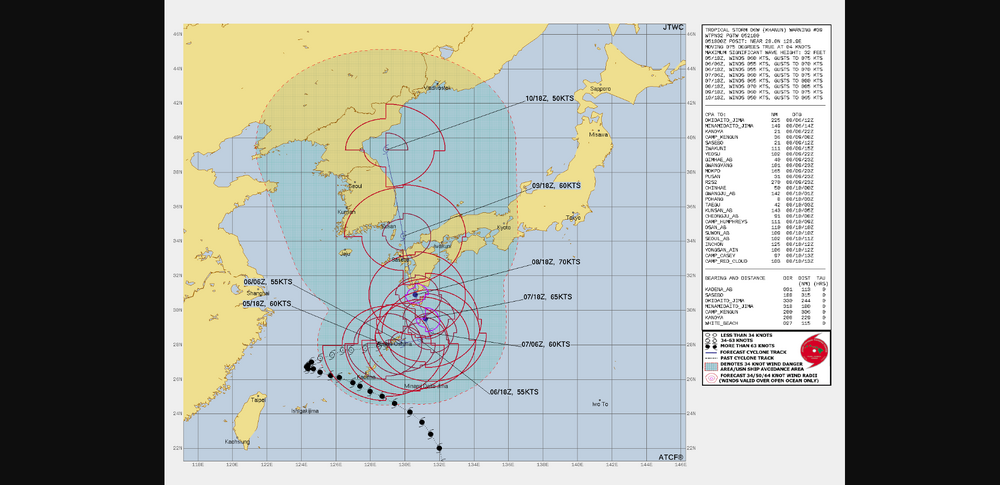
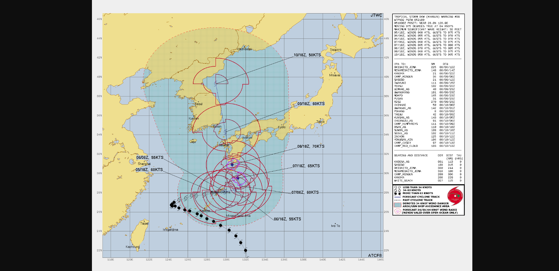
KHAHUN,is a pretty amazing storm,just basically stuck in no mans land with no steering current to kick it.Today the Euro shows it going into South Korea around Mid week finally,tho this could change.This pattern if this storm gets into Korea/Sea of Japan should set up a +PNA.Think we could see once again the potential for a MId Level Ridge build back up to our SW,this would give us a decent shot at MCS action as we head towards next weekend and into it.Unless the models change,we are fixing to get possibly into a real wet pattern in several days
'
It’s amazing how wet this summer has already been. If we don’t dry out some it could set us up for some major flooding issues going into fall & winter. Long way out but I don’t see the wet weather shutting off anytime soon.
-
1
-
-
The incredible summer of wet & not hot continues. My monthly HVAC usage report for June was 98 hours less cooling than last June. I’m thinking July will be less cooling days than last July. Said average high temp. for June was 86. Last year it was 88.
Now hopefully winter does the opposite of predicted & gives us SNOW!
-
1
-

2023 Fall Mid-Long Term Discussion.
in Tennessee Valley
Posted
Well one thing is looking likely. Dry conditions will persist. Yes some light rain to settle the dust but that’s about all. The temps will be nearly perfect. My grass seed will love the temps. Just going to have to water myself.