-
Posts
624 -
Joined
-
Last visited
Content Type
Profiles
Blogs
Forums
American Weather
Media Demo
Store
Gallery
Posts posted by Matthew70
-
-
4 minutes ago, Carvers Gap said:
That is awfully close to a '96 redux if I have the storm correct. Take a minute and look in the Lakes...there is the problem.
We get about another 150 mile push south with the colder air. ALL of TN will be in a sweet spot. One can hope for ALL of us.
-
3 minutes ago, Carvers Gap said:
Tough to tell. The 12z cmc is a big nada. The 12z GFS is basically one big cold front crashing eastward. Really the only difference between the two is the GFS has what is called an anafront - and I am still not sure that I am using the right term there. Basically the cold air just plows under the warm air and forces the warm/moist air to rise. Rising air produces precip. The big thing is the precip is behind the from on the GFS and in front of it on the CMC. The GFS solution makes good sense since the air behind it is so cold. And....the cold will be coming across new snow in the MidWest.
The CMC is it really ever right? Seems it’s the Hail Mary of models to me. Lol. Kinda like the Icon. Would be funny to see the DGEX clown maps these days. Those were always hilarious to see.
-
2 minutes ago, Carvers Gap said:
Tough to tell. The 12z cmc is a big nada. The 12z GFS is basically one big cold front crashing eastward. Really the only difference between the two is the GFS has what is called an anafront - and I am still not sure that I am using the right term there. Basically the cold air just plows under the warm air and forces the warm/moist air to rise. Rising air produces precip. The big thing is the precip is behind the from on the GFS and in front of it on the CMC. The GFS solution makes good sense since the air behind it is so cold. And....the cold will be coming across new snow in the MidWest.
You are correct in calling it an anafront. We have had a few of those in the past. Rare but happens occasionally.
-
1 minute ago, Carvers Gap said:
This reminds me of the Christmas storm from a few years ago(Jan 16h). If we can catch a wave (without a warm nose), we could be in business. We will see. Still in the game, so that is good.
Right now I see this being a mixed bag for much of the forum area. Hopefully not all out ice storm. As usual I40 is the battle zone. I do believe the colder air will be further south. Models struggle with it as we all know. Fun to be able to track & chat about.
-
 2
2
-
-
1 minute ago, Carvers Gap said:
I just don't see it with the Friday system. I could easily be wrong. OHX would be much more familiar with your area. Maybe the Plateau and higher elevations of E TN. Could be a dusting, but who knows. These systems are powerhouses.
I’m sure they meant Plateau.
-
 1
1
-
-
1 minute ago, Carvers Gap said:
We may be dealing with an anafront? Is that the right term?
This is for the Friday system correct? NWS OHX is saying maybe up to 1” with snow showers Friday night.
-
40 minutes ago, Carvers Gap said:
So that there is no confusion, I am talking about the storm on the 16th and not this weekend.
That’s the one I am also talking about.
-
28 minutes ago, Carvers Gap said:
This is gonna be a wild ride. The 18z EPS...not a bad trend. The MA has some discussion about it. Moves the trough around 150...further eastward. Hope that trend continues - I think I hope that it continues.
I could see this being a big surprise for much of the forum area. Now not saying it will be snow but ice could be the major issue. Having such cold air so close spells surprises many of the times for the mid south. If the LP is 150 miles more SE then look out. Either way we are going to get beneficial rains.
-
I believe the Friday system is not done trending SE. Arctic air always presses further south than models show.
-
 3
3
-
-
19 minutes ago, John1122 said:
GFS is gonna be a big one for at least Western areas and maybe the whole forum area. Looks better than 00 or 06z.
I’d feel more comfortable if the GFS was not alone. Though ensembles do favor the GFS. Euro is one I like to have saying yes instead of no.
-
2 hours ago, Carvers Gap said:
Cosgrove had his weekly update last night. Here is a quote from him:
That rare case of a cAk vortex in Michigan is important in that it will be very tough for anyone living east of the Rocky Mountains to see any warm air. Most of the schemes show a brief moderation to the right of the Mississippi River and Great Lakes in the 16-20 day time frame. But the weeks 5 and 6 outlines seem to have a +PNA/-AO/-NAO alignment.So for all of you who were singing the blues about being bypassed for winter from the Great Plains to the East Coast, this is a chance for normality. And maybe something more. Like perhaps a "for real" snow and ice event in the Mid-Atlantic and New England states in the last week of January and much of next month.
Does he not think the MJO will rule the pattern?
-
18 minutes ago, Carvers Gap said:
Big thing is to sit back and watch trends over the next few days. This could be great or not great. Trends often don't favor us in the Upper South, but sometimes they do. If it works out -> bonus. If not -> lots of other great things to do in life!
It’s fun to actually feel like we’re tracking. This is within 10 days. Pretty incredible.
-
 1
1
-
-
The storm Friday is close to producing some frozen precip also. As long as this keeps moving forward. No more can kicking. Pretty amazing that it’s seemed like winter for the last few weeks. Cloudy & cold. Highs in the 40’s lows in 20’s.
-
 3
3
-
-
Just now, Carvers Gap said:
That was just for posterity. I highly doubt we swing that, but we can dream, right! I will say that the pattern may try to reload yet again after that. Wherever that boundary sets up is likely gonna get hammered.
I definitely don’t see that happening but dreaming is fun. History does produce the unthinkable sometimes. We are due in this area forum wide for history to say it’s time.
-
 2
2
-
-
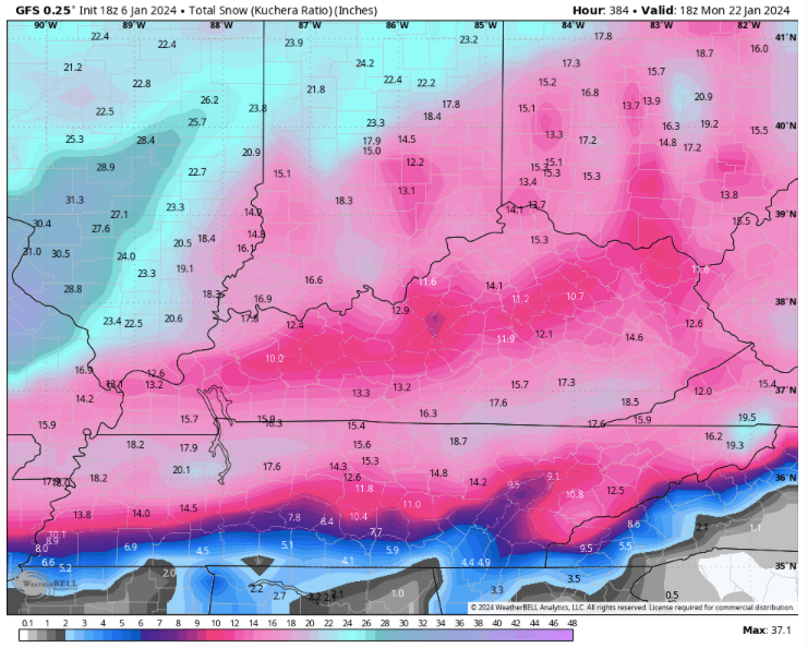
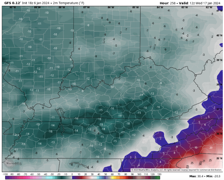
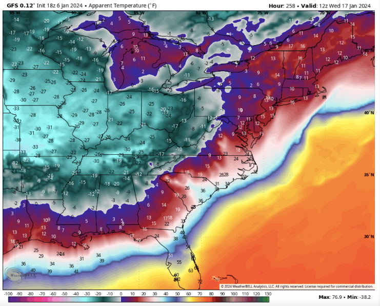
14 minutes ago, Carvers Gap said:
We get that much snow forum wide & those temps. Yep I will say thank you winter. Now where is spring because that would shut down most of the state for several days. Snow days would be used up quickly for the schools.
-
 2
2
-
-
I don’t expect those type of temps nor that much snow but history shows that extremes like this have happened here before. So anything is possible. Though if it’s going to be that cold. Then yes please snow that much to protect my new landscaping.
-
 1
1
-
-
1 hour ago, Carvers Gap said:
The Euro ext (weeklies) might give us a five day warm-up from Jan20-25...then back in the barrel.
If anything like the warmups so far that would be average highs.
-
1 hour ago, tnweathernut said:
Banter, but.................another pipe busting cold snap with no snow would kill my soul. Just want to put that out there. I'm sure I'm not alone. lol
Also if anything like last years. Landscaping killer.
-
 1
1
-
-
Hopefully we get snow on ground before that kinda cold. Otherwise just dry & cold. I’ll take a hard pass.
-
 3
3
-
-
20 minutes ago, weathertree4u2 said:
And just like that it is different on the GFS
Still great trends.
-
I did see an interesting quote from a top meteorologist out of the NE. He said “that the low placements 3 days out are usually on average 150 miles off of where they will usually end up”.
-
 4
4
-
-
9 minutes ago, John1122 said:
I think we'd term that "a good run" of the GFS.
What is the ole saying? Everything always snaps back the other way like a rubber band to equal it all out.
-
 5
5
-
-
I am thinking the warm up is not the warm up that we are accustomed to. If there is really much of a warm up. I also remember strong -NAO being a trump card in the past. Maybe my mind is remembering incorrectly. Also is there still a PV split or partial? That could definitely play in our favor or against us. Maybe this time it plays in our favor. Positive side is the cold is in Canada & very nearby now. Marginal temps are being pushed south. We are going to get moisture even if it’s rain or frozen. That’s a change from the dry pattern.
-
 4
4
-
-
Maybe false hope but I feel the MJO forecast are wrong or it will be overridden by other factors. -NAO. PV split. Only time will tell.
-
 2
2
-


January Medium-Long Range Discussion
in Tennessee Valley
Posted
If it’s going to get that cold, I sure hope we do have snow to cover my new landscape so it does not get killed by the freezing temperatures.