MikeB_01
-
Posts
2,125 -
Joined
-
Last visited
Content Type
Profiles
Blogs
Forums
American Weather
Media Demo
Store
Gallery
Everything posted by MikeB_01
-

Western Pa / Pittsburgh area Winter Discussion ❄️☃️
MikeB_01 replied to north pgh's topic in Upstate New York/Pennsylvania
Just like the euro. Model watching games are in full effect right now -
Western Pa / Pittsburgh area Winter Discussion ❄️☃️
MikeB_01 replied to north pgh's topic in Upstate New York/Pennsylvania
I think the precip coming down a little bit is due to the trough being a little flatter than it was on previous runs. Regardess of what the snowfall totals are on this run, the energy remained relatively the same -
Western Pa / Pittsburgh area Winter Discussion ❄️☃️
MikeB_01 replied to north pgh's topic in Upstate New York/Pennsylvania
Seems ok for the uncertainty in the models. Definitely conservative -
Western Pa / Pittsburgh area Winter Discussion ❄️☃️
MikeB_01 replied to north pgh's topic in Upstate New York/Pennsylvania
At hour 60 little further west and stronger. Both are better for us. Not a huge improvement, but better than GFS/Can -
Western Pa / Pittsburgh area Winter Discussion ❄️☃️
MikeB_01 replied to north pgh's topic in Upstate New York/Pennsylvania
Honestly, that 12z run of the RGEM is better than the previous 00z and 6z The position of the energy and the low is further west. The precip shield isn't as impressive, but im not too worries about that. Keep watching the energy -
Western Pa / Pittsburgh area Winter Discussion ❄️☃️
MikeB_01 replied to north pgh's topic in Upstate New York/Pennsylvania
If i had an inch of snow for every time i've said this sentence. -
Western Pa / Pittsburgh area Winter Discussion ❄️☃️
MikeB_01 replied to north pgh's topic in Upstate New York/Pennsylvania
First one with true samplings is probably 00z tonight. Just speculating though. -
Western Pa / Pittsburgh area Winter Discussion ❄️☃️
MikeB_01 replied to north pgh's topic in Upstate New York/Pennsylvania
wouldn't mind that band setting up over the area for a while. -
Western Pa / Pittsburgh area Winter Discussion ❄️☃️
MikeB_01 replied to north pgh's topic in Upstate New York/Pennsylvania
I know it’s not a weather point, but this snow looks awesome in the Christmas lights... I feel like it’s been a while since we’ve have a nice December event with all the lights up . -
Western Pa / Pittsburgh area Winter Discussion ❄️☃️
MikeB_01 replied to north pgh's topic in Upstate New York/Pennsylvania
Temps are dropping as well so that snow ratio is climbing! -
Western Pa / Pittsburgh area Winter Discussion ❄️☃️
MikeB_01 replied to north pgh's topic in Upstate New York/Pennsylvania
Honestly, chances for 4+ looking pretty good. I will say, I am a little nervous and skeptical about this one. Relying on the backend of a system to cool the column enough to start snowing is something that I have a hard time relying on. It just never seems to happen fast enough without drying out the column at the same time. Model support seems good this time, but i wouldn't be surprised to see the low end of these amounts either.
-
Pittsburgh PA Spring and Summer 2020 Thread
MikeB_01 replied to meatwad's topic in Upstate New York/Pennsylvania
It’s been years. I feel like September has been August 2.0. This is refreshing. . -
Pittsburgh PA Spring and Summer 2020 Thread
MikeB_01 replied to meatwad's topic in Upstate New York/Pennsylvania
Haha this would be too typical in the winter, but it also feels like this is the way summer is going too. I wish there was a metric to determine how much thunderstorm activity we’ve had this summer. I know it has been try, but I feel like we’ve really lacked those nice afternoon boomers as well. Maybe just me in the south hills? . -
Pittsburgh PA Spring and Summer 2020 Thread
MikeB_01 replied to meatwad's topic in Upstate New York/Pennsylvania
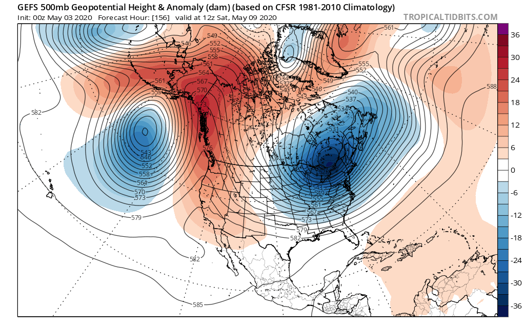
a blocking pattern finally decides to show up. On may 9th.
-
Pittsburgh PA Spring and Summer 2020 Thread
MikeB_01 replied to meatwad's topic in Upstate New York/Pennsylvania
From November through April. A perpetual state of 40° . -
Pittsburgh PA Spring and Summer 2020 Thread
MikeB_01 replied to meatwad's topic in Upstate New York/Pennsylvania
What time are we thinking here? 2-2:30? I was going to try to sleep for a little before . -
Pittsburgh/Western PA Banter & Complaint Thread
MikeB_01 replied to blackngoldrules's topic in Upstate New York/Pennsylvania
10 year anniversary of a major screw job... https://projects.ncsu.edu/atmos_collaboration/nwsfo/storage/cases/20091218/ -
Pittsburgh/Western PA Banter & Complaint Thread
MikeB_01 replied to blackngoldrules's topic in Upstate New York/Pennsylvania
LOL -
Pittsburgh/Western PA Banter & Complaint Thread
MikeB_01 replied to blackngoldrules's topic in Upstate New York/Pennsylvania
Atmosphere is looking loaded for tomorrow afternoon. Even though the sounding is saying "Tor" I am not sure i buy that. Not enough directional shear for it imo. Damaging straight line winds look more likely -
Pittsburgh/Western PA Banter & Complaint Thread
MikeB_01 replied to blackngoldrules's topic in Upstate New York/Pennsylvania
Noticed they uped it to Enhanced at the for the latest outlook. Saturday is looking juiced up and ready to go as well. -
Pittsburgh/Western PA Banter & Complaint Thread
MikeB_01 replied to blackngoldrules's topic in Upstate New York/Pennsylvania
Anyone else already tired of Jeff V on twitter? All I hear about it "No hype" / "No Fearcasting". Great, that is really appreciated. Some stations are notorious for fearcasting, I get it. But come one, he didn't even start talking about accumulating snow until Friday night. He was still saying "snow shower". -
Pittsburgh/Western PA Banter & Complaint Thread
MikeB_01 replied to blackngoldrules's topic in Upstate New York/Pennsylvania
F Boston and their 12" snow storm. They complained all year and it looks like they will be rewarded with it. They got a decent hit today and another one coming tomorrow -
Pittsburgh/Western PA Banter & Complaint Thread
MikeB_01 replied to blackngoldrules's topic in Upstate New York/Pennsylvania
How bad has the NAM been at temp profiling this winter? 12Z nam still had freezing rain at the onset of the precip tonight. My house in already at 33°. Well before any precip makes it to the area. -
Pittsburgh/Western PA Banter & Complaint Thread
MikeB_01 replied to blackngoldrules's topic in Upstate New York/Pennsylvania
Does every system have to cut through Ohio? Like watching a bunch of bowling balls roll through -
Pittsburgh/Western PA Banter & Complaint Thread
MikeB_01 replied to blackngoldrules's topic in Upstate New York/Pennsylvania
F weather. .