

MikeB_01
-
Posts
2,125 -
Joined
-
Last visited
Content Type
Profiles
Blogs
Forums
American Weather
Media Demo
Store
Gallery
Everything posted by MikeB_01
-

Western Pa / Pittsburgh area Winter Discussion ❄️☃️
MikeB_01 replied to north pgh's topic in Upstate New York/Pennsylvania
Snow depth by the Euro. Ensemble mean is up to 4+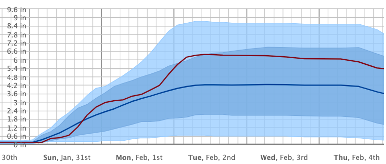
-
Western Pa / Pittsburgh area Winter Discussion ❄️☃️
MikeB_01 replied to north pgh's topic in Upstate New York/Pennsylvania
Nothing wrong with this -
Western Pa / Pittsburgh area Winter Discussion ❄️☃️
MikeB_01 replied to north pgh's topic in Upstate New York/Pennsylvania
The Euro cuts off as well. This keeps some of that energy associated with the primary over us a little long before fizzling out. -
Western Pa / Pittsburgh area Winter Discussion ❄️☃️
MikeB_01 replied to north pgh's topic in Upstate New York/Pennsylvania
Yes. Our precip is almost entirely coming from the primary. The snow that hangs around is not from the coastal, but it is from a secondary trough of LP that is coming down after the primary comes through. -
Western Pa / Pittsburgh area Winter Discussion ❄️☃️
MikeB_01 replied to north pgh's topic in Upstate New York/Pennsylvania
All sleet here . -
Western Pa / Pittsburgh area Winter Discussion ❄️☃️
MikeB_01 replied to north pgh's topic in Upstate New York/Pennsylvania
We knew we couldn’t avoid the tongue all winter. I’m amazed we held off this long . -
Western Pa / Pittsburgh area Winter Discussion ❄️☃️
MikeB_01 replied to north pgh's topic in Upstate New York/Pennsylvania
Awesome snow falling right now in the south hills . -
Western Pa / Pittsburgh area Winter Discussion ❄️☃️
MikeB_01 replied to north pgh's topic in Upstate New York/Pennsylvania
The dog days of winter. This is the time of year that is so tough. It’s cold, it’s dreary, and unless there is a storm to track it’s boring haha. Hoping for something to track soon. Second half of the month looks promising. Just need to hold out for it. . -
Western Pa / Pittsburgh area Winter Discussion ❄️☃️
MikeB_01 replied to north pgh's topic in Upstate New York/Pennsylvania
Perfect Christmas morning. Coming down right now. . -
Western Pa / Pittsburgh area Winter Discussion ❄️☃️
MikeB_01 replied to north pgh's topic in Upstate New York/Pennsylvania
I have about 4" out there. A slight under performer, but nothing better than Christmas snow. Merry Christmas my friends. Enjoy the snow! -
Western Pa / Pittsburgh area Winter Discussion ❄️☃️
MikeB_01 replied to north pgh's topic in Upstate New York/Pennsylvania
Not sure how much is out there. I still have some grass poking out of the top. The most impressive thing is how cold it is right now. Crazy different from 6 hours ago . -
Western Pa / Pittsburgh area Winter Discussion ❄️☃️
MikeB_01 replied to north pgh's topic in Upstate New York/Pennsylvania
Still snow here in the south hills. That bubble of mixed precip, I’m not sure about how valid that is.MPING reports seem to be all snow where the radar is still indicating mix. . -
Western Pa / Pittsburgh area Winter Discussion ❄️☃️
MikeB_01 replied to north pgh's topic in Upstate New York/Pennsylvania
Seems to have switched to all snow pretty quick. Coming down. . -
Western Pa / Pittsburgh area Winter Discussion ❄️☃️
MikeB_01 replied to north pgh's topic in Upstate New York/Pennsylvania
Snow mixing in with the sleet now. It’s coming. . -
Western Pa / Pittsburgh area Winter Discussion ❄️☃️
MikeB_01 replied to north pgh's topic in Upstate New York/Pennsylvania
I’ve never seen sleet this hard lol. Got a nice layer of sleet on some surfaces . -
Western Pa / Pittsburgh area Winter Discussion ❄️☃️
MikeB_01 replied to north pgh's topic in Upstate New York/Pennsylvania
So far this is timing out to be pretty spot on with the models... -
Western Pa / Pittsburgh area Winter Discussion ❄️☃️
MikeB_01 replied to north pgh's topic in Upstate New York/Pennsylvania
on its way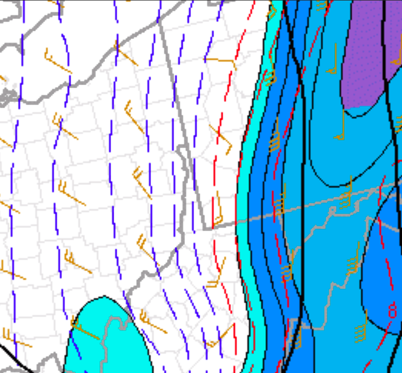
-
Western Pa / Pittsburgh area Winter Discussion ❄️☃️
MikeB_01 replied to north pgh's topic in Upstate New York/Pennsylvania
HEAVY Sleet in Lebo right now... -
Western Pa / Pittsburgh area Winter Discussion ❄️☃️
MikeB_01 replied to north pgh's topic in Upstate New York/Pennsylvania
Cold Front on its way into Youngstown. A sharp one right there. . -
Western Pa / Pittsburgh area Winter Discussion ❄️☃️
MikeB_01 replied to north pgh's topic in Upstate New York/Pennsylvania
You never know what a closed off low is going to do. -
Western Pa / Pittsburgh area Winter Discussion ❄️☃️
MikeB_01 replied to north pgh's topic in Upstate New York/Pennsylvania
00z tonight will give you that 36 hr run. Not sure how great the model performs that far out though. . -
Western Pa / Pittsburgh area Winter Discussion ❄️☃️
MikeB_01 replied to north pgh's topic in Upstate New York/Pennsylvania
i'll take it. Some lake effect should make a very beautiful Christmas day as well. -
Western Pa / Pittsburgh area Winter Discussion ❄️☃️
MikeB_01 replied to north pgh's topic in Upstate New York/Pennsylvania
-
Western Pa / Pittsburgh area Winter Discussion ❄️☃️
MikeB_01 replied to north pgh's topic in Upstate New York/Pennsylvania
A strange scenario to see the cut off low that brings such cold air yet has such an impressive ridge ahead of it. Its all timing and once this low cuts off, who knows how it will meander around. If it cuts off later we probably get through the rain faster and into the colder air. Ideally, we want to low to be cut off and slow down one the cold air is in place. The meandering low would give us plenty of energy to bring some nice snow rates. -
Western Pa / Pittsburgh area Winter Discussion ❄️☃️
MikeB_01 replied to north pgh's topic in Upstate New York/Pennsylvania
Now that is a trough...


