MikeB_01
-
Posts
2,125 -
Joined
-
Last visited
Content Type
Profiles
Blogs
Forums
American Weather
Media Demo
Store
Gallery
Everything posted by MikeB_01
-

Western PA/Pittsburgh Winter 2021/22 Discussion
MikeB_01 replied to meatwad's topic in Upstate New York/Pennsylvania
Absolutely. The 12z has more of a zonal look rather than the more amplified look we were seeing over the last few runs. Plenty of time for it to shift back. -
Western PA/Pittsburgh Winter 2021/22 Discussion
MikeB_01 replied to meatwad's topic in Upstate New York/Pennsylvania
200 mile shift to the southeast on the 12z Euro -
Western PA/Pittsburgh Winter 2021/22 Discussion
MikeB_01 replied to meatwad's topic in Upstate New York/Pennsylvania
Yes. Definitely not worried yet. Euro coming in now. Interesting to see if it shifts like the Ukie -
Western PA/Pittsburgh Winter 2021/22 Discussion
MikeB_01 replied to meatwad's topic in Upstate New York/Pennsylvania
oooofff -
Western PA/Pittsburgh Winter 2021/22 Discussion
MikeB_01 replied to meatwad's topic in Upstate New York/Pennsylvania
06z GEFS is pretty weak, but its there. Defitely nothing like what the other models are currently showing -
Western PA/Pittsburgh Fall Weather Discussion
MikeB_01 replied to Ahoff's topic in Upstate New York/Pennsylvania
. -
Western PA/Pittsburgh Summer Discussion 2021
MikeB_01 replied to Ahoff's topic in Upstate New York/Pennsylvania
No we did not have one, but as of yesterday kpit came out and officially announced the end of the growing season for Nov 1. Therefore ending their frost and freeze advisories until spring time. . -
Western PA/Pittsburgh Fall Weather Discussion
MikeB_01 replied to Ahoff's topic in Upstate New York/Pennsylvania
Interesting that they would mention weakening after sunset. I mean that is how it usually goes, but instability was never really a factor yesterday anyway. It was all about the wind shear. I’m sure the sunset could have caused slight weakening, but the main fuel for those storms was the shear . -
Western PA/Pittsburgh Fall Weather Discussion
MikeB_01 replied to Ahoff's topic in Upstate New York/Pennsylvania
I had no thunder, but it has been a little breezy. Also, cool to be in the bullseye of low pressure for the system. Bottomed out at 1003mb at my house. . -
Western PA/Pittsburgh Fall Weather Discussion
MikeB_01 replied to Ahoff's topic in Upstate New York/Pennsylvania
The perfect weather day today to make us think fall! [emoji260] . -
Western PA/Pittsburgh Summer Discussion 2021
MikeB_01 replied to Ahoff's topic in Upstate New York/Pennsylvania
. -
Western PA/Pittsburgh Summer Discussion 2021
MikeB_01 replied to Ahoff's topic in Upstate New York/Pennsylvania
. -
Western PA/Pittsburgh Summer Discussion 2021
MikeB_01 replied to Ahoff's topic in Upstate New York/Pennsylvania
2.85” in the rain gauge so far. This includes yesterday. . -
Western PA/Pittsburgh Spring Discussion 2021
MikeB_01 replied to Ahoff's topic in Upstate New York/Pennsylvania
Just a few drops this morning here. Really hope to hear some thunder later. -
Western PA/Pittsburgh Spring Discussion 2021
MikeB_01 replied to Ahoff's topic in Upstate New York/Pennsylvania
NWS forecast for Wed, thurs, fri, sat is 81, 84, 86, and 84. Get the AC ready. Summer is here. . -
Western Pa / Pittsburgh area Winter Discussion ❄️☃️
MikeB_01 replied to north pgh's topic in Upstate New York/Pennsylvania
Yea, I'll admit i was wrong on this one. I thought the radar started to fill in around 9:00. As quickly as it filled in, it went away. HRRR still shows redevelopment once the suns goes down. We shall see. -
Western Pa / Pittsburgh area Winter Discussion ❄️☃️
MikeB_01 replied to north pgh's topic in Upstate New York/Pennsylvania
Radar already starting to fill in again. I think this has been as advertised so far. This dry slot was showing up on the hres models yesterday, but I just think everything got started a few hours earlier than what was modeled. It started earlier, we dry slotted earlier, and looks like we are filling in earlier. . -
Western Pa / Pittsburgh area Winter Discussion ❄️☃️
MikeB_01 replied to north pgh's topic in Upstate New York/Pennsylvania
Yea saw that on the hi-res models earlier today, but definitely not this early. NWS was saying sometime between 12-2 am. I'm hoping this is a good sign? -
Western Pa / Pittsburgh area Winter Discussion ❄️☃️
MikeB_01 replied to north pgh's topic in Upstate New York/Pennsylvania
I am seeing some flakes too. This seems a little earlier than modeled. I wonder if this is an earlier arrival or a bigger precip field? -
Western Pa / Pittsburgh area Winter Discussion ❄️☃️
MikeB_01 replied to north pgh's topic in Upstate New York/Pennsylvania
My thoughts exactly. I hope the eastward hault that we saw with the 06z suit continues and even comes a little west. Might be able to get that 3-5 if that happens. -
Western Pa / Pittsburgh area Winter Discussion ❄️☃️
MikeB_01 replied to north pgh's topic in Upstate New York/Pennsylvania
-
Western Pa / Pittsburgh area Winter Discussion ❄️☃️
MikeB_01 replied to north pgh's topic in Upstate New York/Pennsylvania
Oh look... The Euro got even worse. Sleep well everyone. There will be storms for us to track. This one just isn't it.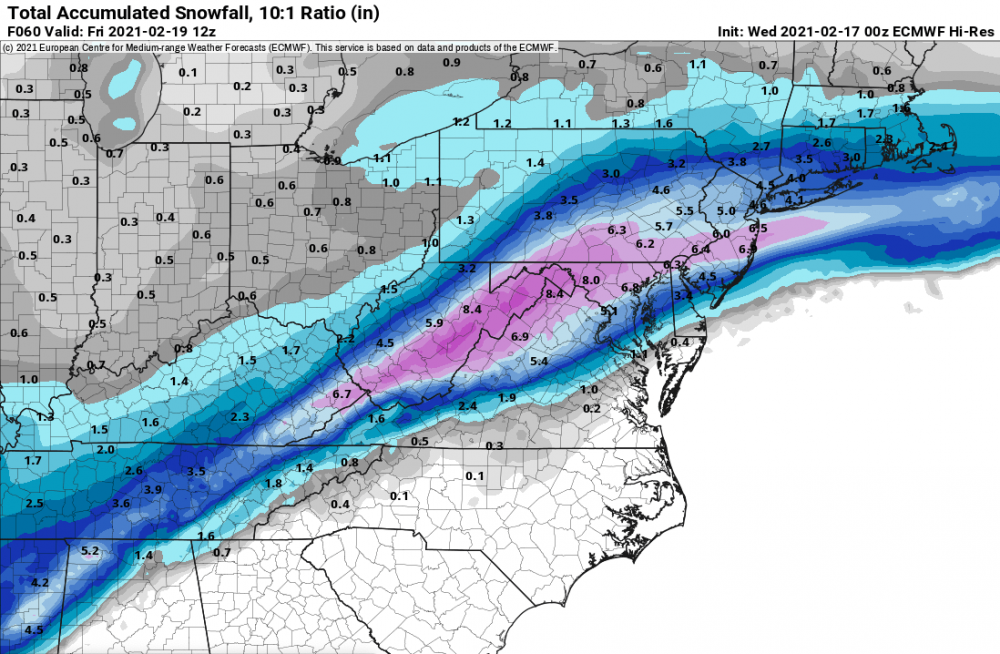
-
Western Pa / Pittsburgh area Winter Discussion ❄️☃️
MikeB_01 replied to north pgh's topic in Upstate New York/Pennsylvania
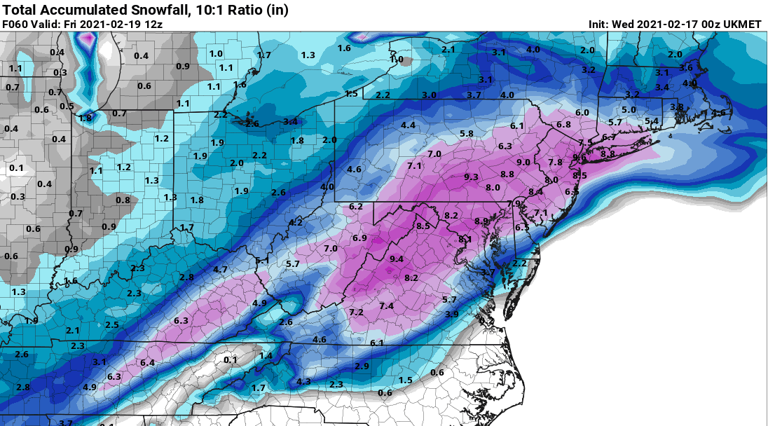
UKie is better than others, but still falling to the SE trend.
-
Western Pa / Pittsburgh area Winter Discussion ❄️☃️
MikeB_01 replied to north pgh's topic in Upstate New York/Pennsylvania
HREF for thursday- friday. Something interesting that is showing itself on the hires models is another dry slot just like we had with this past storm. Looks like i would snow thursday morning, take a break and then start back up with another round. Havent been seeing that on some of the mid range models. No matter, the HREF just like all other guidance at this point is focusing in on 2-4 over the course of 18-24 hours. Maybe we can get the last second jog to the NW. Doubt it, but maybe.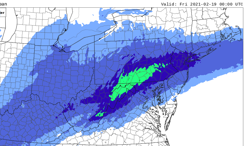
-
Western Pa / Pittsburgh area Winter Discussion ❄️☃️
MikeB_01 replied to north pgh's topic in Upstate New York/Pennsylvania
There. No one should feel too bad about this past storm. Had to go really far west to find deep snow. Can’t believe how far the warm air pushed .