MikeB_01
-
Posts
2,125 -
Joined
-
Last visited
Content Type
Profiles
Blogs
Forums
American Weather
Media Demo
Store
Gallery
Everything posted by MikeB_01
-

Western Pa / Pittsburgh area Winter Discussion ❄️☃️
MikeB_01 replied to north pgh's topic in Upstate New York/Pennsylvania
Was just going to post something about this. GFS still wants to bring the cold and keep it around for a while, but the Eruo is showing 26° warmer tuesday morning than what is showed yesterday at this time. Strange turn around -
Western Pa / Pittsburgh area Winter Discussion ❄️☃️
MikeB_01 replied to north pgh's topic in Upstate New York/Pennsylvania
Love that pink color so close to us. Not something we see often. This winter hasn’t been enough. I need more. . -
Western Pa / Pittsburgh area Winter Discussion ❄️☃️
MikeB_01 replied to north pgh's topic in Upstate New York/Pennsylvania
big time differences between the Euro and GFS on this next week. Euro shows this monster of a storm and the GFS brings some strung out energy through with a front and drops a couple inches. This evolution will be fascinating. -
Western Pa / Pittsburgh area Winter Discussion ❄️☃️
MikeB_01 replied to north pgh's topic in Upstate New York/Pennsylvania
Just your typical category 1 hurricane in February -
Western Pa / Pittsburgh area Winter Discussion ❄️☃️
MikeB_01 replied to north pgh's topic in Upstate New York/Pennsylvania
https://www.earthcam.com/usa/newyork/timessquare/?cam=tsrobo1 Just for fun. If you can get on now, it is absolutely puking snow in times square right now. Looks dark enough to be a thunderstorm. -
Western Pa / Pittsburgh area Winter Discussion ❄️☃️
MikeB_01 replied to north pgh's topic in Upstate New York/Pennsylvania
Seems like a good set up for snow. Just need it to play out that way -
Western Pa / Pittsburgh area Winter Discussion ❄️☃️
MikeB_01 replied to north pgh's topic in Upstate New York/Pennsylvania
Very cold air coming next Sunday/ Monday. Windchills well below zero . -
Western Pa / Pittsburgh area Winter Discussion ❄️☃️
MikeB_01 replied to north pgh's topic in Upstate New York/Pennsylvania
I’ll gladly still take 4-6 . -
Western Pa / Pittsburgh area Winter Discussion ❄️☃️
MikeB_01 replied to north pgh's topic in Upstate New York/Pennsylvania
Finally starting to see some snow again in Mt Lebanon. Very light, but at least it’s snowing. . -
Western Pa / Pittsburgh area Winter Discussion ❄️☃️
MikeB_01 replied to north pgh's topic in Upstate New York/Pennsylvania
Snow to the north and snow to the south. Someone get me out of this hell hole . -
Western Pa / Pittsburgh area Winter Discussion ❄️☃️
MikeB_01 replied to north pgh's topic in Upstate New York/Pennsylvania
This dry air just won’t budge. . -
Western Pa / Pittsburgh area Winter Discussion ❄️☃️
MikeB_01 replied to north pgh's topic in Upstate New York/Pennsylvania
Rain snow line is terrifyingly close. Anyone down there to confirm rain in Washington County? . -
Western Pa / Pittsburgh area Winter Discussion ❄️☃️
MikeB_01 replied to north pgh's topic in Upstate New York/Pennsylvania
https://www.youtube.com/watch?v=9wL1W8zjEsU Eric Wilhelm- meteorologist out of Youngstown, talking about today. . -
Western Pa / Pittsburgh area Winter Discussion ❄️☃️
MikeB_01 replied to north pgh's topic in Upstate New York/Pennsylvania
As of noon... . -
Western Pa / Pittsburgh area Winter Discussion ❄️☃️
MikeB_01 replied to north pgh's topic in Upstate New York/Pennsylvania
Agree. I think we will get to 6+, but we need to be patient while we wait for the radar to fill in. Still fighting off the dry air. Best snow comes last this afternoon and into tonight. . -
Western Pa / Pittsburgh area Winter Discussion ❄️☃️
MikeB_01 replied to north pgh's topic in Upstate New York/Pennsylvania
This is what I was talking about in my concerns. Radar will fill in as the day goes on. We are like 6 hours in to a 36 hour event. . -
Western Pa / Pittsburgh area Winter Discussion ❄️☃️
MikeB_01 replied to north pgh's topic in Upstate New York/Pennsylvania
They have 6-8 in their discussion. I think they just need to update their graphics. Probably middle of the night -
Western Pa / Pittsburgh area Winter Discussion ❄️☃️
MikeB_01 replied to north pgh's topic in Upstate New York/Pennsylvania
Good lord -
Western Pa / Pittsburgh area Winter Discussion ❄️☃️
MikeB_01 replied to north pgh's topic in Upstate New York/Pennsylvania
I say it every storm, and I’m sure I’m in the minority here, but I love the SREFs . -
Western Pa / Pittsburgh area Winter Discussion ❄️☃️
MikeB_01 replied to north pgh's topic in Upstate New York/Pennsylvania
This is my fear as well. Need to watch the 850 levels tomorrow. . -
Western Pa / Pittsburgh area Winter Discussion ❄️☃️
MikeB_01 replied to north pgh's topic in Upstate New York/Pennsylvania
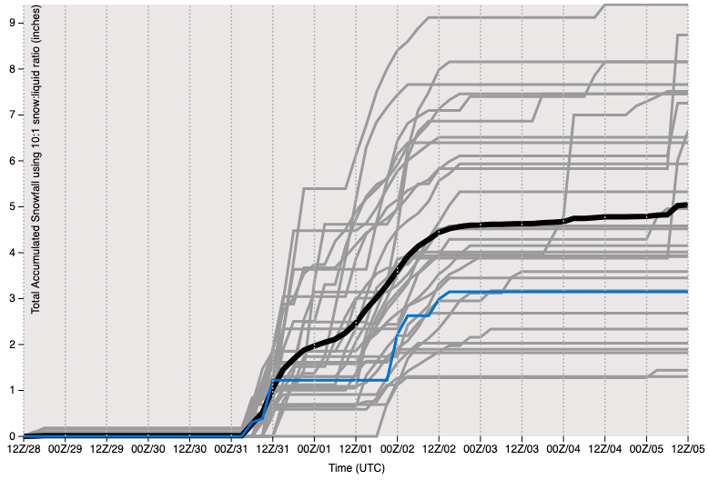
The consistency that is starting to come in with the models is a very good sign. Led by the Euro (of course) we have been moving in the right direct since Thursday. A few things that concern me at this point. There is some dry air aloft seems to be eating away at some of the precip shield. Right now, there is only happening in NE Ohio and NW PA. I worry that there is not much room and if the dry air sinks a little bit further south, we could lose some precip for a while. The other thing is the DWTD coming in from the south. Its a hairpin away. The sounding of the 12z NAM show just how close it is in the mid levels. I could easily see us sleeting for a while tomorrow afternoon. Things look good for right now and Im feeling much better about a 6+ snow, but we need to stay where we are. Not a whole lot of room for error in the next few runs.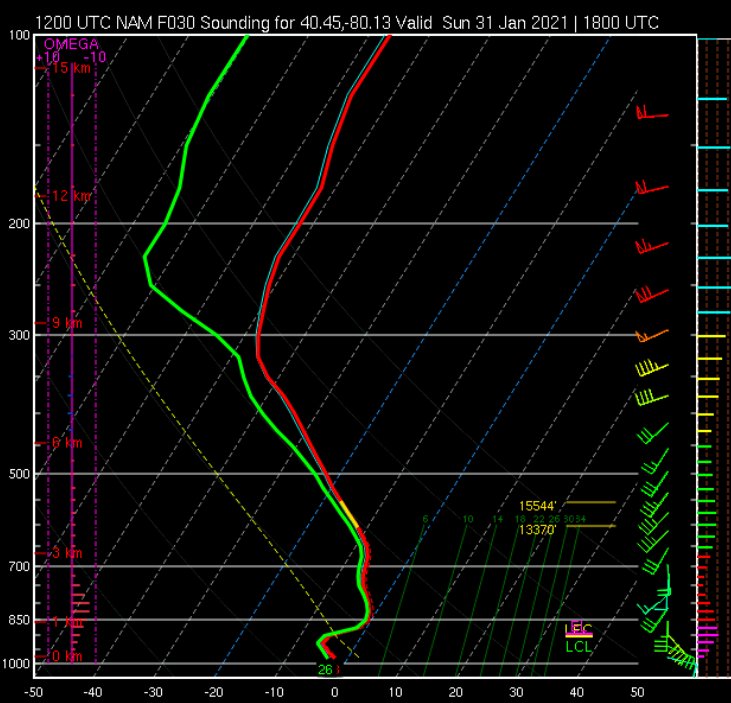
-
Western Pa / Pittsburgh area Winter Discussion ❄️☃️
MikeB_01 replied to north pgh's topic in Upstate New York/Pennsylvania
When I saw this set up a few days ago, I thought this would be an event where we would get 1-2” on the front end, mix/rain, then 1” on the back. As the models rolled big over the last few runs, my hopes got a little higher, but I’m not surprised to see the lower GFS run. . -
Western Pa / Pittsburgh area Winter Discussion ❄️☃️
MikeB_01 replied to north pgh's topic in Upstate New York/Pennsylvania
From earlier today, but I think it’s worth showing. Euro in a good spot . -
Western Pa / Pittsburgh area Winter Discussion ❄️☃️
MikeB_01 replied to north pgh's topic in Upstate New York/Pennsylvania
Still a long way out. No need to be scared lol . -
Western Pa / Pittsburgh area Winter Discussion ❄️☃️
MikeB_01 replied to north pgh's topic in Upstate New York/Pennsylvania
GEFS plumes. A lot to like here