MikeB_01
-
Posts
2,125 -
Joined
-
Last visited
Content Type
Profiles
Blogs
Forums
American Weather
Media Demo
Store
Gallery
Everything posted by MikeB_01
-

Western Pa / Pittsburgh area Winter Discussion ❄️☃️
MikeB_01 replied to north pgh's topic in Upstate New York/Pennsylvania
Invest in RadarScope. Only $10 a year for the phone app. I never use anything else for radar . -
Western Pa / Pittsburgh area Winter Discussion ❄️☃️
MikeB_01 replied to north pgh's topic in Upstate New York/Pennsylvania
Terrific mood snow. Fireplace roaring, Christmas lights on, 10” snowpack on the ground, and the most perfect light snow falling outside my windows. This is what dreams are made of. . -
Western Pa / Pittsburgh area Winter Discussion ❄️☃️
MikeB_01 replied to north pgh's topic in Upstate New York/Pennsylvania
looking ahead to next week. This is a pretty cold looking map. Christmas night could be very chilly. -
Western Pa / Pittsburgh area Winter Discussion ❄️☃️
MikeB_01 replied to north pgh's topic in Upstate New York/Pennsylvania
10.25” as of 7 am here in Mt Lebanon. That was fun considering all but an inch of that fell in 12 hours. Awesome . -
Western Pa / Pittsburgh area Winter Discussion ❄️☃️
MikeB_01 replied to north pgh's topic in Upstate New York/Pennsylvania
RAP shows another 4+ hours of snow and then tapering off. This storm has been fun -
Western Pa / Pittsburgh area Winter Discussion ❄️☃️
MikeB_01 replied to north pgh's topic in Upstate New York/Pennsylvania
Snow porning right now in the south hills. Beautiful... . -
Western Pa / Pittsburgh area Winter Discussion ❄️☃️
MikeB_01 replied to north pgh's topic in Upstate New York/Pennsylvania
This is always my go to https://www.spc.noaa.gov/exper/mesoanalysis/new/viewsector.php?sector=17 . -
Western Pa / Pittsburgh area Winter Discussion ❄️☃️
MikeB_01 replied to north pgh's topic in Upstate New York/Pennsylvania
this band is juicy -
Western Pa / Pittsburgh area Winter Discussion ❄️☃️
MikeB_01 replied to north pgh's topic in Upstate New York/Pennsylvania
-
Western Pa / Pittsburgh area Winter Discussion ❄️☃️
MikeB_01 replied to north pgh's topic in Upstate New York/Pennsylvania
Maybe someone who is way smarter can help me here... I noticed that the low at 700 has closed off. Does this do anything? I don't think it was depicted on the models. -
Western Pa / Pittsburgh area Winter Discussion ❄️☃️
MikeB_01 replied to north pgh's topic in Upstate New York/Pennsylvania
he's back! -
Western Pa / Pittsburgh area Winter Discussion ❄️☃️
MikeB_01 replied to north pgh's topic in Upstate New York/Pennsylvania
Looking really good out there right now. -
Western Pa / Pittsburgh area Winter Discussion ❄️☃️
MikeB_01 replied to north pgh's topic in Upstate New York/Pennsylvania
anyone else notice this on the 12z NAM? That warm nose is showing itself awfully close to AGC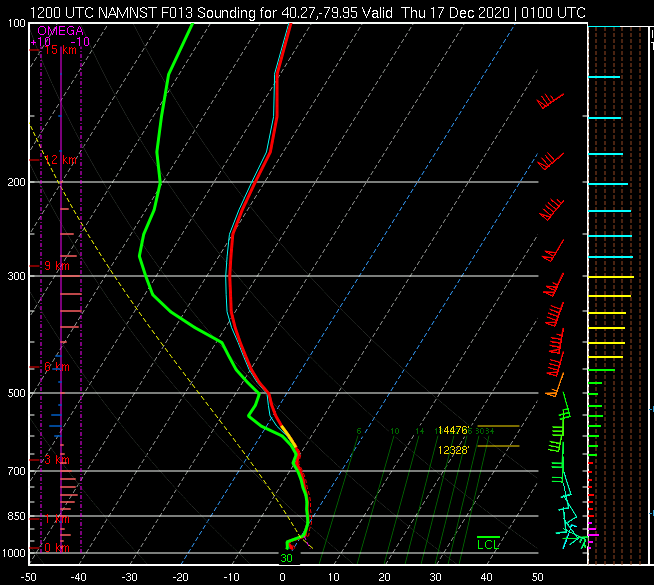
-
Western Pa / Pittsburgh area Winter Discussion ❄️☃️
MikeB_01 replied to north pgh's topic in Upstate New York/Pennsylvania
Do we think this is because it is moving faster or because the precip shield is larger? -
Western Pa / Pittsburgh area Winter Discussion ❄️☃️
MikeB_01 replied to north pgh's topic in Upstate New York/Pennsylvania
Nice to get that base coat down. Time to pile it up! -
Pittsburgh/Western PA Banter & Complaint Thread
MikeB_01 replied to blackngoldrules's topic in Upstate New York/Pennsylvania
i knew i could find you in here lol -
Western Pa / Pittsburgh area Winter Discussion ❄️☃️
MikeB_01 replied to north pgh's topic in Upstate New York/Pennsylvania
so you're saying theres a chance... -
Western Pa / Pittsburgh area Winter Discussion ❄️☃️
MikeB_01 replied to north pgh's topic in Upstate New York/Pennsylvania
As i sit here watching the 00z suite come in, the PA central folks jump for joy, and the morale of our own group wains faster than our snowfall totals. For a moment, I am going to put my rose-colored glasses on and try to keep a few things in perspective. 1. Models have been trending in our way all day. 1-2 model runs back in the other direction doesn't kill our dreams. 2. 6-8 is still a really good storm and this is what I think the most of us will still see. Is it 30? no, but we will keep hoping for that. 3. Storms that ride up from the south like this always seem to amplify more than what the models think. Remember Jan 2016 --I was thinking 3-4" event and it over amplified into a 9" storm for me. On the other side, Jan 2019-- the models had us constantly on the mix line. Snow to mix and back to snow, hoping to get 3-4 " out of it. It over amplified again and we rained for nearly the entire storm. So if the models are trending a little lower in your area, keep in mind that these things have a tendency to go a little NW than what the models think. 4. I will enjoy the snow falling down tomorrow regardless of if we get 4, 6, 8, 10 or 12. But im hoping for 12! Enjoy your night everyone. -
Western Pa / Pittsburgh area Winter Discussion ❄️☃️
MikeB_01 replied to north pgh's topic in Upstate New York/Pennsylvania
Positive thought on the NAM.. We were happy with the 00z run last night. Tonights run is essentially a carbon copy. Its crunch time now. We can watch the models come in tonight, but we all know that this is coming down to watching its progression tomorrow morning. -
Western Pa / Pittsburgh area Winter Discussion ❄️☃️
MikeB_01 replied to north pgh's topic in Upstate New York/Pennsylvania
once the euro comes in they will do an update -
Western Pa / Pittsburgh area Winter Discussion ❄️☃️
MikeB_01 replied to north pgh's topic in Upstate New York/Pennsylvania
Was just going to post this as well. Good to see the HREF on our side. Inject the max straight into my veins, please. -
Western Pa / Pittsburgh area Winter Discussion ❄️☃️
MikeB_01 replied to north pgh's topic in Upstate New York/Pennsylvania
January 19? 2019 maybe... We got all rain and Youngstown received a foot of snow -
Western Pa / Pittsburgh area Winter Discussion ❄️☃️
MikeB_01 replied to north pgh's topic in Upstate New York/Pennsylvania
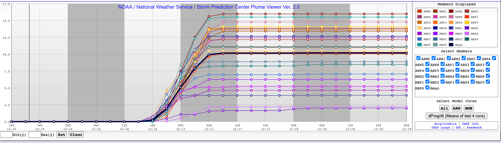
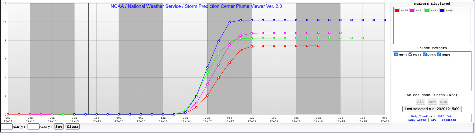
SREF. I like this model. I know that everyone does not, but its trending better as well. Up to 10 for kpit

-
Western Pa / Pittsburgh area Winter Discussion ❄️☃️
MikeB_01 replied to north pgh's topic in Upstate New York/Pennsylvania
24 hour trend in at the 500 level. Slight, but definitely moving in the right direction. Precip also moving that direction over the 24 hours period. -
Western Pa / Pittsburgh area Winter Discussion ❄️☃️
MikeB_01 replied to north pgh's topic in Upstate New York/Pennsylvania
Anyone have a Euro map to post? .