MikeB_01
-
Posts
2,125 -
Joined
-
Last visited
Content Type
Profiles
Blogs
Forums
American Weather
Media Demo
Store
Gallery
Everything posted by MikeB_01
-

Western Pa / Pittsburgh area Winter Discussion ❄️☃️
MikeB_01 replied to north pgh's topic in Upstate New York/Pennsylvania
Horrendous. 25 miles makes a huge difference . -
Western Pa / Pittsburgh area Winter Discussion ❄️☃️
MikeB_01 replied to north pgh's topic in Upstate New York/Pennsylvania
The NAM does a few things. It generally has way more ice than other models. It also can have a tendency to overdo the rate at which the system deepens. These rapidly deepening systems tend to over amplify and then push the rain snow line further north. NWS discussion from 8 am this morning still in the camp of the forecast remaining on track. I’ll be watching the HRRR and the SREFs (my favorites) today to see how things look. . -
Western Pa / Pittsburgh area Winter Discussion ❄️☃️
MikeB_01 replied to north pgh's topic in Upstate New York/Pennsylvania
I’ll take this position right now. Time for it to swing a little further south tomorrow. 24 hours to go. Lots of time. . -
Western Pa / Pittsburgh area Winter Discussion ❄️☃️
MikeB_01 replied to north pgh's topic in Upstate New York/Pennsylvania
Definitely. No Jeff V here. He is probably still calling for “snow showers”. . -
Western Pa / Pittsburgh area Winter Discussion ❄️☃️
MikeB_01 replied to north pgh's topic in Upstate New York/Pennsylvania
He’s generally fairly conservative too. I’ve had a few chances to talk with him. Good guy who loves the weather and knows his stuff. I’ll take this map and hope we over perform and get 12+ here in the south hills. . -
Western Pa / Pittsburgh area Winter Discussion ❄️☃️
MikeB_01 replied to north pgh's topic in Upstate New York/Pennsylvania
We know that we need to be super close if we are going to get the highest totals. We are going to sweat for the next 60 straight hours . -
Western Pa / Pittsburgh area Winter Discussion ❄️☃️
MikeB_01 replied to north pgh's topic in Upstate New York/Pennsylvania
Lol everyone take a deep breath. I’m worried about the mixing too but I’m not jumping ship after one run. Sometimes these models wobble. Like a windshield. . -
Western Pa / Pittsburgh area Winter Discussion ❄️☃️
MikeB_01 replied to north pgh's topic in Upstate New York/Pennsylvania
Canadian...
-
Western Pa / Pittsburgh area Winter Discussion ❄️☃️
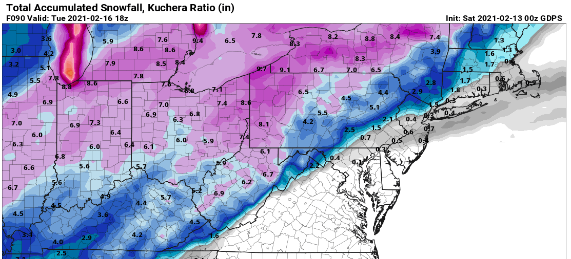
MikeB_01 replied to north pgh's topic in Upstate New York/Pennsylvania
I did a little digging into some of the soundings for the GFS run tonight. The graphic has mixed precip making it to the AGC/ Wash county line. Interestingly, though the graphic shows mix, the sounding would indicate snow --> not sure what he error is in the algorithm there. That being said, that warm nose is strong. This is going to be a tight one. Here is the sounding for 06z tue. 19° but damn does that temp get close to 32° at the 850 level.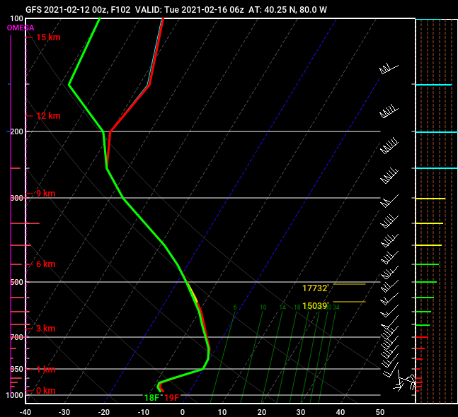
-
Western Pa / Pittsburgh area Winter Discussion ❄️☃️
MikeB_01 replied to north pgh's topic in Upstate New York/Pennsylvania
Has to do with the data collection around the country. If you look at the observational soundings (balloon launches), most CWAs launch at 00z and 12z. This data is fed directly into the models runs at those times. Very few CWAs have launches at the 6z and 18z times. Only a few and in special circumstances will launch then. -
Western Pa / Pittsburgh area Winter Discussion ❄️☃️
MikeB_01 replied to north pgh's topic in Upstate New York/Pennsylvania
This will be a key race to watch regarding the monday / tuesday system. If the northern energy can get a little further south that will suppress the storm energy (circled in blue) further to the south as well. The timing of these two pieces and the positions that they take will be critical. At this point, any guess in on the table, but for right now, we are still close enough to be in the game. -
Western Pa / Pittsburgh area Winter Discussion ❄️☃️
MikeB_01 replied to north pgh's topic in Upstate New York/Pennsylvania
Yea I noticed that too. Not too far off from what the model showed. Need to start watching this area now for some redevelopment. The HRRR has been hitting on some light snow developing in this area that kept the snow falling though the night. -
Western Pa / Pittsburgh area Winter Discussion ❄️☃️
MikeB_01 replied to north pgh's topic in Upstate New York/Pennsylvania
Starting to see some fine flakes falling in Mt. Lebanon -
Western Pa / Pittsburgh area Winter Discussion ❄️☃️
MikeB_01 replied to north pgh's topic in Upstate New York/Pennsylvania
I know.. just enjoying the giant donut hole . -
Western Pa / Pittsburgh area Winter Discussion ❄️☃️
MikeB_01 replied to north pgh's topic in Upstate New York/Pennsylvania
-
Western Pa / Pittsburgh area Winter Discussion ❄️☃️
MikeB_01 replied to north pgh's topic in Upstate New York/Pennsylvania
4.75 here in Mt. Lebanon. Lets see if this lighter stuff off to the north can slip a little further to the south -
Western Pa / Pittsburgh area Winter Discussion ❄️☃️
MikeB_01 replied to north pgh's topic in Upstate New York/Pennsylvania
Here are the top 15 snows from that year --- somehow we managed to get to 63.4" Only two storms were above 3" the entire winter. -
Western Pa / Pittsburgh area Winter Discussion ❄️☃️
MikeB_01 replied to north pgh's topic in Upstate New York/Pennsylvania
Yea just took the trash out to the curb. Coming down good and already giving the street a good sugar coat . -
Western Pa / Pittsburgh area Winter Discussion ❄️☃️
MikeB_01 replied to north pgh's topic in Upstate New York/Pennsylvania
Loving this trend . -
Western Pa / Pittsburgh area Winter Discussion ❄️☃️
MikeB_01 replied to north pgh's topic in Upstate New York/Pennsylvania
Triggered lol. No one drives me more insane than Jeff V. The “most accurate” weather forecast. He’s never wrong because he never makes a prediction. . -
Western Pa / Pittsburgh area Winter Discussion ❄️☃️
MikeB_01 replied to north pgh's topic in Upstate New York/Pennsylvania
Just for fun --> Here is the 2m anomaly for that outbreak in 94.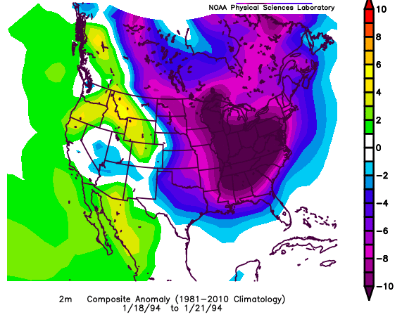
-
Western Pa / Pittsburgh area Winter Discussion ❄️☃️
MikeB_01 replied to north pgh's topic in Upstate New York/Pennsylvania
here is the top 10 coldest three day lows on record. If the GFS has the right idea for Feb 14-16, we are looking at a top 5 cold outbreak.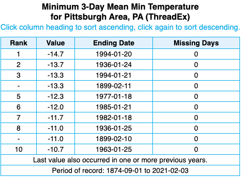
-
Western Pa / Pittsburgh area Winter Discussion ❄️☃️
MikeB_01 replied to north pgh's topic in Upstate New York/Pennsylvania
I've been seeing a mix but sometimes it comes down as all snow and it's huge flakes. I've always loved the size of the snow flakes when it's getting ready to mix or change over. Yes just noticed the mix too. Definitely having some rain mix in. -
Western Pa / Pittsburgh area Winter Discussion ❄️☃️
MikeB_01 replied to north pgh's topic in Upstate New York/Pennsylvania
Giant flakes right now in Mt. Lebanon. Looks awesome outside right now. -
Western Pa / Pittsburgh area Winter Discussion ❄️☃️
MikeB_01 replied to north pgh's topic in Upstate New York/Pennsylvania
Amazing... https://docs.google.com/forms/d/e/1FAIpQLSfAseoytbBJEf_Z1q359eaOp1b7jgBCw-uaIzkF3XPrHa6oXA/viewform