

the_other_guy
-
Posts
2,596 -
Joined
-
Last visited
Content Type
Profiles
Blogs
Forums
American Weather
Media Demo
Store
Gallery
Posts posted by the_other_guy
-
-
Accuweather going with 1-2 for westchester
-
it seems like Mount Holly is worried about mixing near the coast at onset.
But then the models show possible heavy banding along the coast, which would negate that.
Thoughts?
-
-
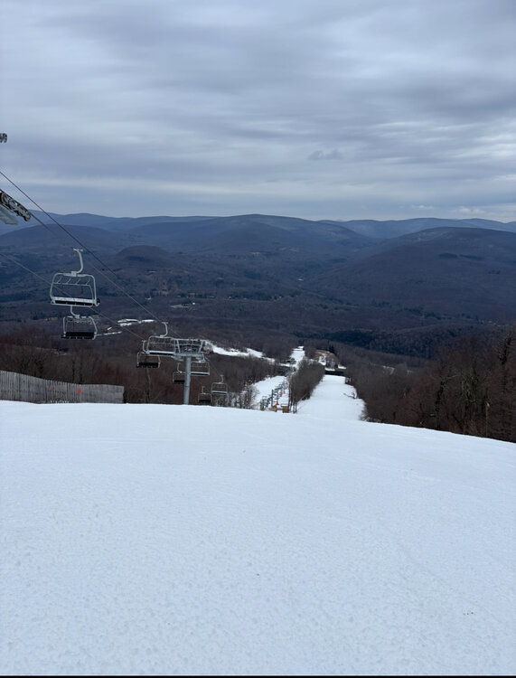
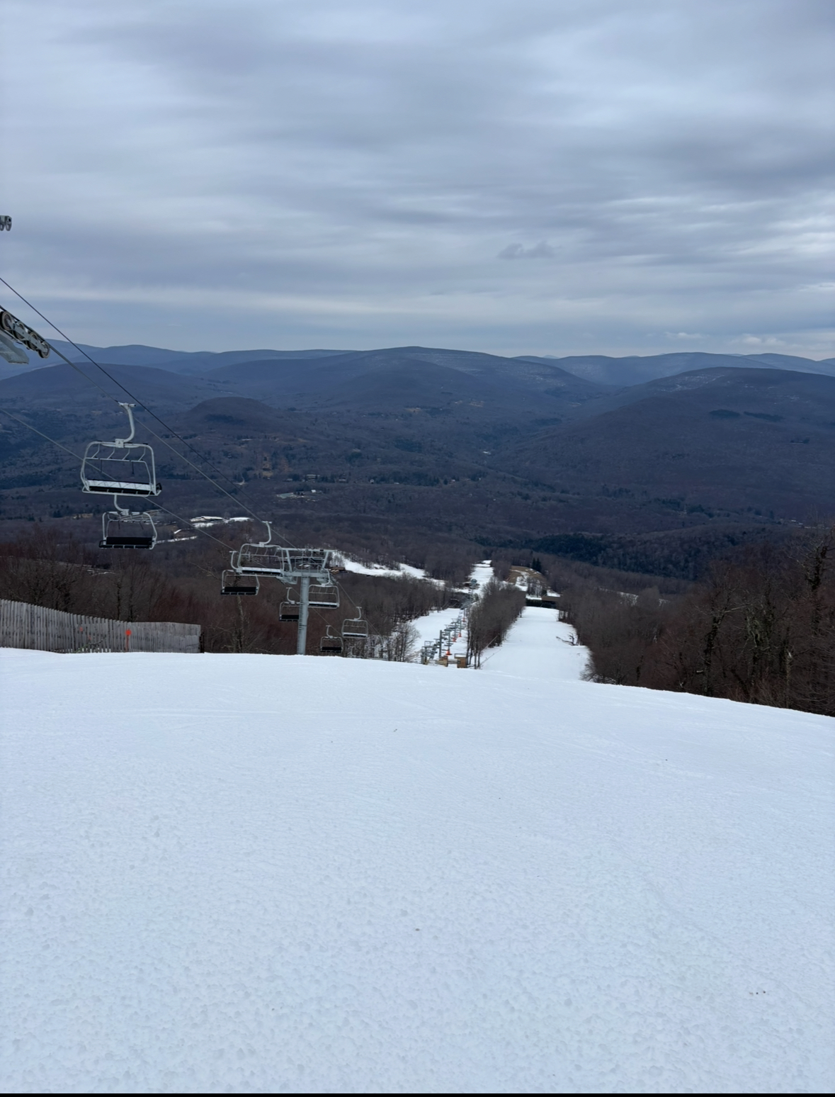
Belleayre today. snow after 3pm
-
 3
3
-
-
4 hours ago, Allsnow said:
Congrats @MJO812
Don’t be a dick guys! he saw it and you guys kept saying nothing was happening
If we get a flake of snow, he was more accurate than most of you on here… a week out
-
1
-
 1
1
-
 2
2
-
 2
2
-
-
9 minutes ago, bluewave said:
It’s a good question. I have noticed that the JFK departures can vary either up or down from the other sites from time to time. It could be the onshore influence.
within the five boroughs and immediate metro area it’s really the only large open field. it’s quite possibly the least affected by man-made structures of all the sites.
I always laugh at the Newark reading. A more disgusting place to take a weather observation I can’t think of: cement, airport, Marine terminal, boats, planes, trains… And you wonder why it’s always so hot.
if you could see Newark from the air, it looks like a kid went wild with every micro machine city possible pushed together on a small table… and there was nothing cooler than micro machines
-
1
-
-
10 minutes ago, bluewave said:
Cold departures pulling back again after the warm up. Should start to increase again with the colder temperatures coming up from the 21st to 23rd. Then the cold departures will recede again following Christmas as we go back up above normal again. The current station average is -1.3. It will be interesting to see if we can get a day or two warm enough near the end of the month to fall in the -1 to +1 range for the average which was my guess at the start of December.
EWR….-0.9
NYC….-1.9
HPN….-1.1
LGA….-1.9
JFK…..+0.2
ISP…..-1.5
BDR…..-1.8
AVG….-1.3
Im assuming JFK has to do with the south wind days and the water?
-
Man, you guys are really miserable. You’re really pushing that last week of December for some torch. It’s gonna be in the freaking 40s.
Listening to some of you, one would think we’d be going for a record-breaking heat.
Some of you must be real fun at the barbecue or a Christmas party
i’m rooting for that Sunday snowstorm just to piss some of you off
-
5
-
 1
1
-
1
-
2
-
-
1 minute ago, NEG NAO said:
when you least expect - its going to happen - not many below average by a few degrees Decembers have no snow even 83 and 89 had over an inch.......
not many below normal December‘s consistently have days around 60. What is this like a once a week occurrence?
-
44 minutes ago, nycwinter said:
a very nice reprieve from the cold today.. many people are wearing hoodies..
wifebeater!
hoodie is for the 30 degree days for the 287 folks. u cement dwellers dont get it
")
-
1 hour ago, EWR757 said:
One nice thing about the stratus and fog on Monday is that the good people of NJ didn't see any space aliens or UFOs, also known as aircraft landing at EWR and TEB.
As the weather becomes VFR later today the "UFOs" should be visible again, well at least when said observers aren't looking at their TikTok or SKIMs discount messages.
From NY Center last week “use caution for lasers. I have had more laser reports along the NJ coast in the last hour than in the last 5 years”
-
25 minutes ago, Stormlover74 said:
Why would Jan and Feb be above normal in snowfall? What is he basing that on?
I mean around here you get 1-10 inch storm in each and you are above normal right?
Not hard to bet the over if you want to make a headline. Especially if we keep getting these cold shots. Eventually something will click
-
4 hours ago, psv88 said:
Happy that the ski mountains have snow. When we in this forum discuss weather and rate winters it’s based on what happens where we live, not in mountains.
So my opinion is less valuable than yours? Okay..how about this? I dont give a damn if you dont like cold without snow. No one else on the forum does either.
Stick to weather and so will I.
-
1
-
-
21 minutes ago, psv88 said:
17 this morning.
cold without snow is a complete waste. It’s the worst type of weather option we have. Cold and bare ground. Horrific.
at least we weren’t shut out for the month out here, but one inch I not much when we’ve had this much cold
A lot of skiers on here disagree with you. Been to Belleayre 3 times already.
Keep the cold coming…snow is gravy
-
2
-
-
What is the analog for a winter with a COLD and SNOWLESS Dec for NYC? Just curious.
Are we in uncharted territory here?
-
18F. Colder last night
-
36 minutes ago, SACRUS said:
NYC
2013: 5 inches of snow mixed with and changed to heavy rain. Total liquid 1.46 inches.I remember that! we still had some snow on the ground after that though.
-
when was the last time we had a below normal December?
That’s an impressive on its own right. Looks like a lock now
-
14F Woof!
-
I don’t understand why guys keep laughing at the possible snowstorm. This is a weather forum. A possible snowstorm in December in New York. It’s not like talking about a hurricane hitting Iowa.
I just don’t get the craziness with the disbelief at the possibility
-
6
-
-
So to summarize:
Lot of cold over the next 10 days…interrupted by a real warm cutter….Wouldnt be Dec without 55 and rain after all...and a nice mild finish to the month.
Sounds like a snowless December to me.
Nice
-
 1
1
-
-
December’s have warmed dramatically, but let’s not pretend that highs in the teens or lows in the single digits were normal in December at any point. that was extreme even 30 years ago.
The problem here is something that blue wave has pointed to. At least for new normals our December is gonna be pretty average… but these storms seem to keep cutting west of us and allowing warm air to come every time precipitation arrives. If we had snow yesterday and three days in the 30s, you would say what a December this is.
But we had rain yesterday and three days in the 30s and then we’re gonna have rain again over the weekend and more cold day behind it.
This is a pattern that’s been in place for at least 10 years now.
It’s a big problem if you want snow.
it was masked in the 2010s because we kept getting these one off big storms that made a month or winter.
-
1 hour ago, bluewave said:
Looks like the fast Pacific flow continues until further notice. Warm ups ahead of the Great Lakes lows and cool downs behind the storms. This could be a -1 to +1 month that doesn’t get decided + or - until New Year’s Eve.


Which is a win temp wise…but this pattern doesnt seem to support any snow
-
this is like a thread in search of a storm haha. All kidding aside just some light rain here in Westchester every now and then a heavy downpour, but it’s nothing too crazy. Certainly no wind at all.
-
1
-
OBS for NYC CP first measurable minor snowfall? 11A Fri 12/20-11A 12/21, embedded with surrounding area periodic minor accumulative snow
in New York City Metro
Posted
Flakes westchester!
MJO, whatever happens today, this is your day to shine!