

the_other_guy
-
Posts
2,237 -
Joined
-
Last visited
Content Type
Profiles
Blogs
Forums
American Weather
Media Demo
Store
Gallery
Posts posted by the_other_guy
-
-
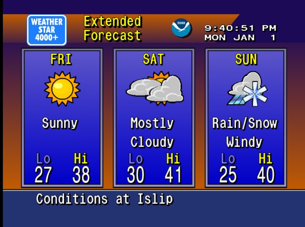
3 minutes ago, MJO812 said:
Interior snowstorm
Not too far in though
-
2 minutes ago, suzook said:
I just moved south of Atlanta off the island. Funny thing down here, is it's been in the mid 20's at night, but warms to the mid 50's during the day. The mid 50's definitely feel a bit warmer though, I guess because the sun does feel a bit stronger.
Very common on clear winter mornings. Get used to it. SE inland radiates very well! Much better than NYC metro
-
 1
1
-
-
21 minutes ago, Rjay said:
Playing Rudolph the Red Nosed Reindeer in the background.
What a blast from past. Thanks for sharing!
-
3
-
-
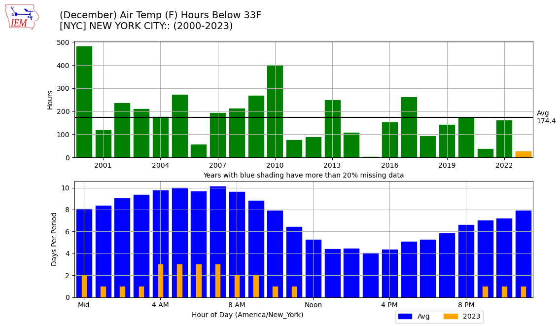
4 minutes ago, donsutherland1 said:
Recent years have seen fewer hours during which the temperature was 32° or below in December:

Look at the huge change in just 20 years! How fucking scary!
-
1
-
-
3 minutes ago, jm1220 said:
Yup. Doesn’t do me any good to see 2-4” snow that’s washed away 6 hours later.
Ill take it. So will most at this point
-
1
-
-
9 minutes ago, Allsnow said:
I like that there’s a storm that we are tracking with this. Makes it all seem possible at least briefly
-
25 minutes ago, psv88 said:
We haven’t been below freezing even here in the suburbs in 6 days. Crazy for end of December and it could be another full week…so that would be 2 weeks without a low below freezing outside of the heat island…
if you live in the suburbs, you’ll be below freezing on the first. But I get your point.
-
28 minutes ago, EastonSN+ said:

Pulling for DC. They already had their first snow would like for them to get another.
never really works out like that though for them. If they get snow and we don’t, it’s because the storm went out to sea below us.
It is very rare where they are getting snow, and we are getting rain simply because they are so much warmer than us. It almost discounts the fact that they are a bit west, and inland.
-
1
-
-
18 hours ago, donsutherland1 said:
That now happens about once every four years. The most recent occurrence prior to this year was 2020. Columbia, SC will have more such days for the first time since 1984 and only 6th time overall.
they will be less affected by AGW than us in terms of cold lows.
They don’t have an urban heat island, and they are inland.
What is missing in this discussion is that the days that go below freezing have the potential to be much lower up here than they do down there.
what is alarming is how few days New York City is now going below freezing.
8% of days. really on the cusp of saying this is no longer a winter city if this continues unabated
Looking into 2024, I dont see many night below freezing for CPK thru mid month
-
4
-
-
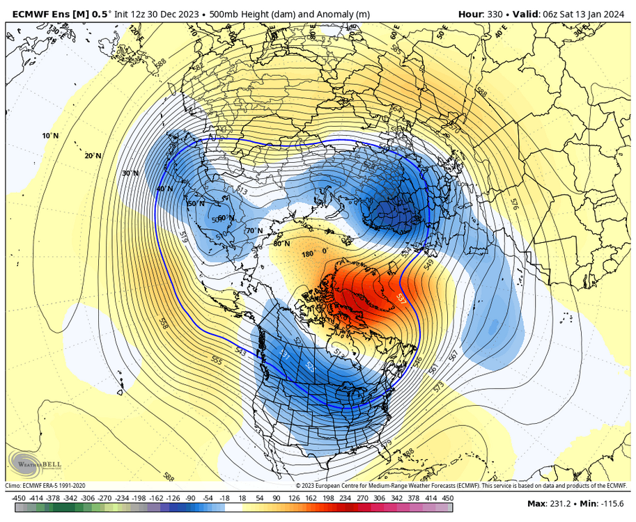
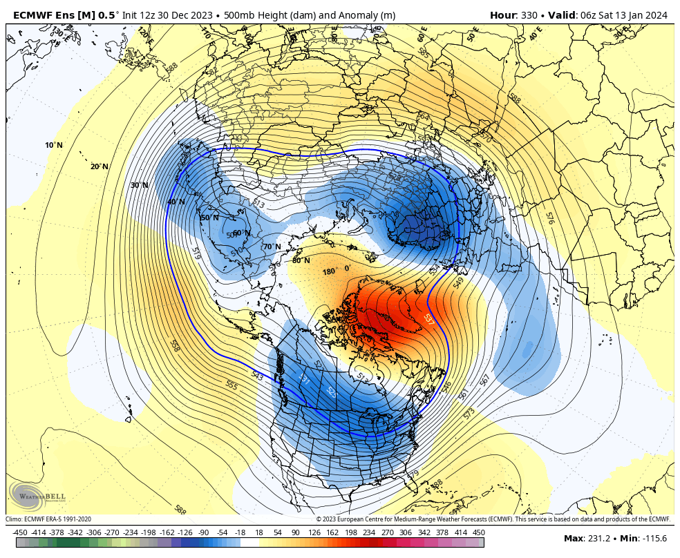
7 minutes ago, NEG NAO said:
maybe it is a good sign for chances of frozen precip that the GFS and Euro are suppressed at this range for the next too storms Jan 4-5 and 6-7 ? Both ensemble mean GEFS and GEPS at 0Z are suppressed BUT the GEPS brings some precip to southern areas of the NYC metro....
This^
-
Moving more into a Seattle/London type winter climate with the pac.
Interesting turn of events to say the least.
I wish the summers would cool down a bit. That would actually make me really happy.
")
-
2
-
-
8 minutes ago, BoulderWX said:
Welcome back to reality! First step is acceptance and good to see you’ve checked that box!
except we’re tracking a storm, right?
Too many guys that don’t know what they’re talking about speaking in absolutes on here.
and for what it’s worth I agree with you. I think it is toast, but it’s January and we’re not out of it yet.
-
5 minutes ago, wdrag said:
There is no doubt(in my mind) that events around the 4th, 7-8th, 10th and possibly well beyond, provide opportunity for snow-ice, at least down to I84 per 24 hours snow depth change ensembles in near normal temps though probs for more than 1" are rather low.
NY eve ball drop might even show flurries nearby NYC w-n suburbs.
All ensembles are above normal precip 4th-14th. Is it rain or snow/ice for I84? Even a chance of snow down to I95.
Does it warm up after the 10th?
Southern streamers look pretty active to me first 2-3 weeks of Jan.
It just doesnt look that cold through 10th though. Need perfect setups
-
36 minutes ago, Stormlover74 said:
No but it's on hiatus
…and the weeks are ticking by quickly
-
1
-
-
43 minutes ago, LibertyBell said:
Do they ever think about damming up these rivers or is that a total no go? It's needed in NJ too
Actually removing a Dam just north of this photo
-
Many people dont realize that the Saw Mill Pkwy is actually the Saw Mill River Pkwy.
next to it is the Saw Mill River, which at most, is a glorified Brook. It now looks like this once a week. Very sad what’s happening here and very alarming.
Anybody that thinks this is in the realm of normal is delusional

-
 1
1
-
-
12 minutes ago, SnoSki14 said:
And yet some will say it's not as bad because it's not Dec 15.
Well +5 against the highest normals is terrible.
But I guess you could be +10 or better like folks further west
this is their 2015. wow this wasn’t the worst December around, the end of it and the transition to January thus far is horrendous.
-
1
-
-
2 hours ago, JustinRP37 said:
Like I have said before, we can skate by with average daily minimums. That would allow local ski areas to make their snow and get open for business. Problem is, I don't even see sustained overnight lows approaching norms for 10+ days. There will be sporadic nights of snowmaking, but this is just getting ridiculous. We have kicked the can and it is starting to be very worrying that even with snowmaking capabilities, southern NY and southern New England resorts will not survive much longer. Then we are looking at the time bomb for northern resorts. Really scary stuff.
well, if you look at a place like Belleayre, they have really invested over the last several summers in new piping and pumping capabilities because they know when it is cold they have to be able to blow huge amounts of snow in very short periods of time.
I would argue that the larger ski areas up north are really going to be affected once the snow and cold temperatures go away. It is easy to blanket a smaller resort like Hunter with man-made snow not so easy for a whiteface or Gore or Killington.
For the first 20 years of my life, we went up to Lake Placid every December to ski at Whiteface. Cold and snow and a frozen lake were a lock. I can’t even remember the last time Lake Placid had a good Christmas week.
If you want to see something scary, go onto whitefacemoutain.com/webcams. it left an impression on me. It looks like a dystopian future hanging on to shreds of a ski resort.
-
1
-
-
28 minutes ago, Allsnow said:
Weeklies flip the pattern to a great look around the 15th into February…
It’s been showing that look for months now unfortunately
Sun angle…
-
1
-
 3
3
-
-
33 minutes ago, MJO812 said:
Only this subforum that thinks winter is canceled.
I mean, looks bad to start January. We have 10 weeks from January 1 to have a winter.
If what Im looking at today is correct (always a big if) we are down to 8.5 weeks to have a winter.
Just a game of attrition.
On a more global scale, NYC has a 15 week snowfall season. Last week of November thru second week of March. By Jan 7, we are 6 weeks in.
It’s like a baseball game the Mets are playing, the Jets in December, or the Knicks with Dolan as owner. Could work, but if you have been around a while, you can start calling these things before half time or the 7th inning stretch
I personally would feel better if December produced anything. Better historical data to cling to
-
1
-
-
13 minutes ago, snowman19 said:
The El Nino winters that had turnarounds after a completely snowless November/December didn’t do so until either the tail end, last week of January or the beginning of February. If we get to 1/20 and there isn’t a sustained change imminent with actual legit cold (not -NAO/-AO trapping PAC air with a +EPO and screaming fast PAC jet with split-flow blasting into the west coast) then we can start thinking of a 97-98 type redux
Right. But then the question becomes how many, how much and for how long.
Snowless Ninos dont usually become prolonged winters
-
1
-
-
23 minutes ago, Allsnow said:
First threat or model run of interest will probably start around the 5/6th. I agree, by the 15th if we are still reading posts from metfan about how the pattern is changing this winter is most likely a punt
The Winter is already a punt. Cruising towards AN temps and BN snow. Questions are: do we get a few snow events or one snow event? Are any of those a blockbuster like 2016?
January opens at a solid +5 for those celebrating the pattern change
-
4
-
-
Forget snow. When is next day CPK goes below freezing?
-
1
-
1
-
-
31 minutes ago, Stormlover74 said:
Maybe...but I go back to my point about AC getting 3 feet in 2021-22 and they average under 12" per year and are considerably warmer than us
OK, but you’re going for one offs then.
Even Washington gets blizzards with two or 3 feet of snow every now and then.
What are you seeing on This board is a majority of people that have not accepted the fact that winter is warm now. they’re getting angry because they expect three months of winter to act differently than the other nine months of the year. They are expecting frequent, frozen precipitation and below freezing weather, and they are expecting temperatures to run out or below normal for extended periods of time.
That isn’t going to happen. There may be some great winter in the future that stands out from all of this… but what has become clear to anybody that wants to see it is that we are running 3 to 5° above normal. And when normal was mid 30s, that’s a really big fucking problem if you like winter weather.
through January 10 I see slightly above normal temperatures. I’m sure we could pick something off. it’s possible. but if you’re looking for 1 to 3 inches here and another 1-3 inches there like its 1986 and looking out at 10 or 11 days of some snow cover on the ground in an urban environment, you are dreaming.
Instead you will get a larger storm that manufactures it’s own cold air that falls and kind of disappears within a few days.
And if you have a good season and the storm track sets up just right, you fall into an Atlantic City situation where you get a number of these type if storms.
-
3
-


Two Mdt to high impact events NYC subforum; wknd Jan 6-7 Incl OBS, and mid week Jan 9-10 (incl OBS). Total water equiv by 00z/11 general 2", possibly 6" includes snow-ice mainly interior. RVR flood potential increases Jan 10 and beyond. Damaging wind.
in New York City Metro
Posted
you guys are throwing in the towel on snow in the city a little too quickly.