

the_other_guy
-
Posts
2,229 -
Joined
-
Last visited
Content Type
Profiles
Blogs
Forums
American Weather
Media Demo
Store
Gallery
Posts posted by the_other_guy
-
-
11 minutes ago, rgwp96 said:
Nws forests for me was 4-6 I doubt I got 2 inches . Not an epic bust but def a bust
Upton did better than Mt Holly with the graphical maps.
-
light snowfalls, and the urban concrete jungle don’t mix well together.
Even if it’s cold out.
-
12 minutes ago, qg_omega said:
She’s done, pretty epic bust for most
it wasn’t a bust at all
Just a bunch of guys talking themselves into a frenzy on a 1-3 inch snowstorm
this was a perfectly modeled, perfectly forecasted, 1 to 3 inch snowstorm.
And as myself and several other posters tried to say yesterday, if you set your expectations for a light snowfall you were going to be happy. And if you set your expectations on a fabricated 6 inch snowfall, you weren’t going to be happy.
-
 3
3
-
 1
1
-
-
2 hour delay for ice.
Preemptive. Who else?
-
4 minutes ago, SnowGoose69 said:
I think the TAFs are a tad too fast at the airports...RASN at LGA by 12Z just seems crazy to me...I'd say PLSN or FZRAPL by 14-15Z makes more sense. The TAFs tend to be automated these days now anyway so often they can disagree with the grids
I just don’t understand what happened with this forecast. any changeover was supposed to be down by the coast at 1 PM now they have me going to ice up here, and the coast going to rain by 10 AM. major shift that I don’t see reflected in the models.
-
1 hour ago, MJO812 said:

given where the storm is now and the fact that LaGuardia is supposed to be over to a mix of rain and snow by 7 AM and then all rain by 9 AM, I’ll call bullshit on this map early on.
I hope I’m wrong, but something happened here today where this changeover is happening a lot earlier than was originally forecast.
-
21 minutes ago, jm1220 said:
If your expectation is for a couple inches to make it wintry outside, maybe 3” if lucky around the city, coast you’ll probably be fine. If you’re holding out for 4” or more you’ll probably be disappointed. Models including the LOL worthy but predictable late NW bump ones show the best snow NW of the city where it won’t change over. This isn’t a major event by any means but will put us all on the board finally. Hopefully Friday will be better. Considering there were zero threats until now it’s a big improvement.
^This
-
wouldn’t it be funny if the main story of this ended up being the ice? 2-4 with ice on top is a much different story than 2-4 period. Much more impactful to travel
-
I think a lot of people on this forum are going to be disappointed tomorrow morning. Not because it’s not gonna snow. it’s definitely gonna snow. You guys are trying to make this a bigger storm than what it is. With each run you’re trying to make this seem like this is a 6 incher that’s coming in. Its not.
Just like last week with each run, you tried to make it seem like it wasn’t going to snow. You guys talk yourself into stuff over and over and then you get disappointed.
Last week was a 6 inch storm with the rain snow line in the Bronx. This is a 3 inch storm outside of urban areas.
-
2
-
 9
9
-
-
3 minutes ago, Stormlover74 said:
That would suck but isn't impossible
for all the noise around Central Park measurements, they essentially got no snow last winter. A tenth up or down, you never looked out and saw white ground in Central Park last winter. To me that makes the record good enough.
-
3 minutes ago, bluewave said:
We may set a new record for late January pattern changes with how amped up this MJO action is.


Transient warm shot hahaha
-
4
-
-
3 hours ago, Allsnow said:
People would have showed up
Would have been packed. 25 years ago schools rarely closed, the trusty 7 train took my mother around in all sorts of storms and blizzards, and the idea of banning travel would have been ludicrous.
Now we live in a world where everyone with a twitter account and an ounce of power feel the need to preemptively declare an emergency, tell us how this setup is more dangerous than anything before, and use both those reasons to take away the right to leave the house from hours before an event to hours or days after.
Cant wait to see my kids school delayed 2 hours for 3 inches of snow on Tuesday because Westchester never saw snow before
-
1
-
-
38 minutes ago, mannynyc said:
Would guess that most snow accumulation will happen tomorrow night and not on Tuesday morning/afternoon based on recent trends.
And that’s what you really want. You want this to fall at night to get maximum accumulation
-
Just now, winterwx21 said:
The timing certainly is good for accumulations since it's coming in overnight into early morning. We should be good for a couple inches here.
I know we don't put a lot of stock in HRRR when it's in its long range, but it definitely looks good on the 12z run.
Start looking at HRRR now
-
Just now, Allsnow said:
Rgem got Colder
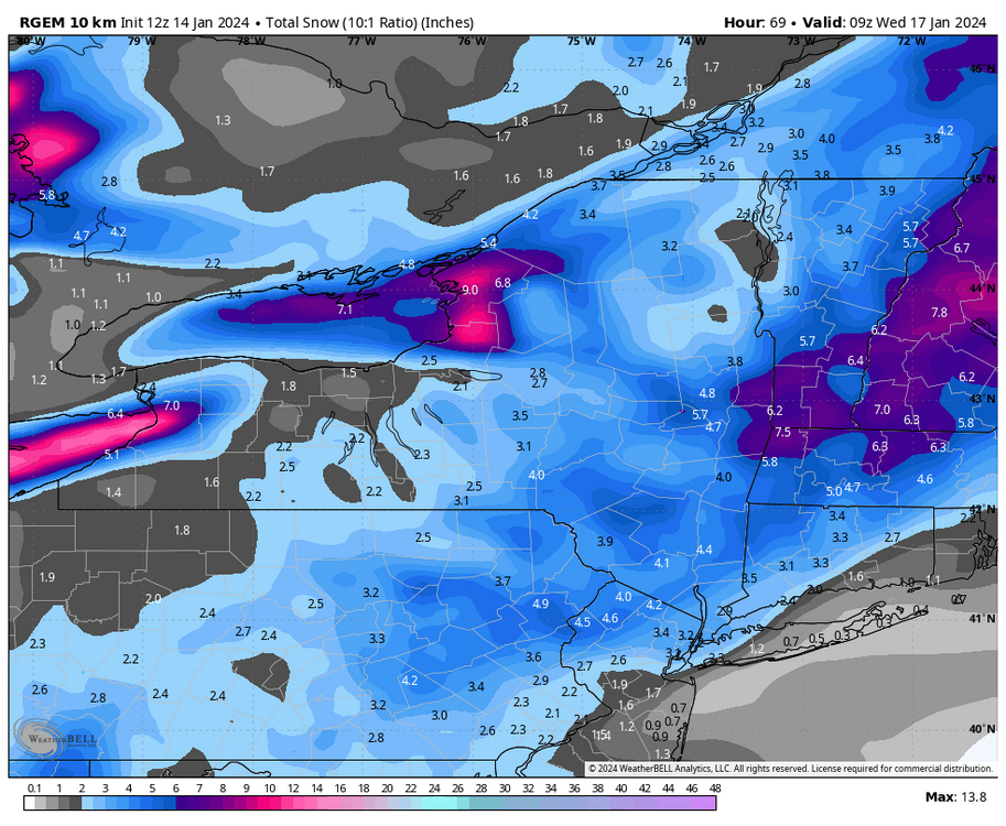
and I think that’s what we’re working with.
Guys keep mentioning higher snowfall amounts. It’s really what it is and if it’s cold enough and if the position is right for it.
There are no warning level snows coming out of this
-
1
-
-
25 minutes ago, jm1220 said:
Don’t be surprised if this trends to crap again for the city east since we normally have these storms trend NW at the end and the SE ridge isn’t modeled too well and often gets stronger closer into the event. And the cold air is really for after this event, not going into it. If we get prolonged easterly wind again near the coast we’re screwed.
There’s just not that much precipitation here on the NAM. At least for NYC Metro
-
2 minutes ago, North and West said:
Are you talking about here? Definitely seems to be in the plains, where it’s been oriented the past decade or so.
.Here. I dont care about KC haha. This is run of the mill winter time “cold” for NYC. Nothing Arctic about it for us.
-
2
-
-
5 hours ago, MJO812 said:
Why do you think that ? Fresh cold air in place.
A few inches might not be out of the question anymore.
it isn’t that cold. It’s like 29 or 30.
You are looking at one aspect, which is the track, but the development and amount of precip are the other aspects.
It keeps backing into coast and (very warm) water comes in, it isnt a good mix for a 1-3 type event.
Daytime, as I mentioned, also sucks for NYC with these small events. Becomes a grass/car topper special on a street with subway lines underneath.
Bluewave said Jan is running +6 in NYC. That is disgustingly warm. Everything is warm. the ground is warm. The water is warm.
-
1
-
-
Cold snap isnt that cold either.
-
1
-
-
9 hours ago, MJO812 said:
This winter might be progressing like 2016. One and done storm unless February turns wintry .
If you are lucky.
-
287 special? I gotta warm up the Horse and Buggy if so…
-
3
-
-
3 minutes ago, LibertyBell said:
what happened to the people who were saying February would be our best month of the winter?
None of these guys know what February will bring. They arent Jehovah. Last week of Jan looks warm. Beyond that, who knows
-
I wish the timing was more night time. 1-3 urban areas in day…eh
-
60F at 10 am on Jan 13.
I mean, if you reflect on that, Holy Shit!
-
1
-


January 2024
in New York City Metro
Posted
Nice sea of warmth after our next dusting/cooldown this weekend.
This fucking winter…that is all