

the_other_guy
-
Posts
2,237 -
Joined
-
Last visited
Content Type
Profiles
Blogs
Forums
American Weather
Media Demo
Store
Gallery
Posts posted by the_other_guy
-
-
9 minutes ago, North and West said:
My family and I on 287
.this may be the best thing to come out of the storm thead!
-
 3
3
-
 3
3
-
-
26 minutes ago, BoulderWX said:
Grosssssss
The models move run to run. it is the same storm for 4 days
A Rain Snow line thru the Bronx + or - a few miles
-
3
-
-
40 minutes ago, allgame830 said:
You guys waffle back n forth wayyyy to much with every model suite…. It’s not a trend until the same solution verifies in multiple model suites!
It is so ridiculous. Meanwhile, thru all the noise on here my stupid accuweather app has shown 3-6 like a rock. And long story short, Im gonna be on the line of something like that
-
1
-
-
18 minutes ago, MJO812 said:
The whole month is done ? Where are you getting that from ?
Not at all. I just dont like how warm it looks. Transient cold.
I surprisingly like this storm chance
-
2
-
-
8 minutes ago, BoulderWX said:
Quickly losing interest in this one but something to track at least. Expecting a sloppy 2-4” here in morris county
why are you losing interest? just curious? you have anything is last year? January looks nice and warm. this may be it for the month
-
3 hours ago, EastonSN+ said:
Could work out a well, all those suppressed snowstorms of the past may be monster hits now. Also the records we have now are likely a combination of a normal warm pattern (decadal RNA now) and GW. If we get back into a general cooler pattern we can be in decent shape.
For me as long as we keep seeing NC, Virginia and the Delmarva get snowstorms like they have been over the past few years we have tread on the tires.
You are looking at interior south vs UHI Coastal NYC.
Not linear. Do not fool yourself with a flawed equation to get an illogical hypothesis.
I have seen that brown line run down the backbone of the Delmarva many times from 37000 feet.
Look at Norfolk. That is your future. Heck, it may be your present.
-
1
-
 1
1
-
1
-
-
Better hope this works out on Saturday. Too much warmth; cold too transient looking ahead
-
3 minutes ago, David-LI said:
Yes, NYC never saw a storm start as pouring rain and warm then switch to snow in the end. /s
I think the last one I could remember was Christmas day like in the early 2000s
It is very rare
there was a much smaller version of that in the late 90s as well. I’m gonna say 1998.
-
1
-
-
Forget backend snows. That doesn’t work in NYC or coastal plain. If you’re going there, it’s already over.
Look at the front end. look at where this thing starts to turn. Im feeling bullish just inland.
-
11 minutes ago, psv88 said:
CNJ, Metro NJ and CT coast are getting rain as well.
For now
1 minute ago, North and West said:
Looks like some accumulating snow for the backwoods people who live on the 287 frontier.
.Yeh. Hillbillies that pay high property taxes dont count
-
1
-
-
2 minutes ago, nightknights said:
Early on and lots of internet announcing massive snowstorm.
The news is right. It is gonna be a big snowstorm for a region that hasnt had much snow in a long time.
It’s just gonna rain on Long Island and New York City.
")
-
2
-
-
11 minutes ago, hudsonvalley21 said:
I know they are all focused on the first event and in this thread also. But another issue is the total QPF forecasted for the next week is concerning for the flooding potential from both events. They haven’t really touched base on that on the tv stations.
Why would they talk about next week when we have a board of experts and enthusiasts that cant really tell us what will happen 2 days from now. We have already established that models are pretty variable outside 72 hours.
Next week may not happen at all. Certainly no way to tell if we have threatening floods until we are 2-3 days out, right? No reason for unwarranted hysteria.
This board would do well with that advice too
-
5 minutes ago, bluewave said:
Definitely. They don’t really come into great focus until into the shorter range. The globals can snow a rain-snow line near the Driscoll bridge days 3-5 that ends up between the GW and Tappan Zee in the mesos once under 36 hrs. This is the challenge of living on such a high population area near the ocean. An error rate like this in the Plains isn’t as important since many regions are much more sparsely populated and would go unnoticed.
It is also a region with varied elevation and a concrete jungle in a very confined space. One naturally affects things. One unnaturally affects things.
-
2
-
-
7 minutes ago, snowman19 said:
How many times have we seen this with southern branch storms over the years? They trend NW in the final 2 days, not SE. It is extremely likely to adjust further NW come the Thursday and Friday….even the Saturday morning runs. Also, what is going to happen to the SE ridge once we see thunderstorm complexes blowing up in the south? (hint, it’s not going to get weaker). Again, I would not at all be surprised to see this become an I-84 north snowstorm by “game time”. You also have to factor in warm noses that are certain to be an issue with the midlevel lows and are not going to be evident right now. We also have a very marginal airmass in the NYC metro areathis hasn’t trended anywhere. It’s in the same spot it was yesterday at this time on models.
What you have here are guys hanging on every single model run for better or worse.
But just to cut through everything, it is showing the same exact positioning on the euro that it did yesterday at this time.
A 287 storm
-
4
-
1
-
-
4 minutes ago, Stormlover74 said:
Last 6 runs of the euro. We're actually back to where we were yesterday at 12z

Glad someone else is following this too.
This is a 3-6 storm for 287 with a lot of noise at this point
-
1
-
2
-
-
1 minute ago, MJO812 said:
Eps is warm and amped. This storm is done for the coast.
Went from promising to nothing .
You declared coast done yesterday at this time also.
Be patient. Lets see later
-
2
-
-
12 minutes ago, mikeysed said:
Looking like up the mountain 4-6" and down Rt 22/ South of 78 2-4" at the moment for us from today's trends.
when you take out all the model variations and everything like that this is what it’s been telling us for a couple of days now.
Not much on the coast, maybe a few slushy inches in the city and immediate northwest burbs, and as you approach 287, you may get closer to 6 inches
-
1
-
-
Can we separate these storm threads? This is too confusing
-
7
-
-
49 minutes ago, vegan_edible said:
gfs in a bit stronger than last night and keeps the fun going with some light-er snow all day sunday. lets hops the cmc and euro show something a little more amped and we find a happy middle ground. im hoping for a solid 5-6inches in white plains. i do wonder though since i've only lived down here for a year and half and experienced snow twice in this region, would y'all consider white plains a "coastal" area?
There are three lines in Westchester. One at the Cross County. One at 287. One where the Taconic and Sprain meet.
Below Cross County you deal with northern NYC forecast. Above that you get progressively snowier with each line. 287 being the big line
-
4
-
1
-
-
31 pages on 1/2.
Just sayin
-
27 minutes ago, Will - Rutgers said:

Babka!
-
2 minutes ago, MJO812 said:
We do fine with Miller Bs but not as good as SNE northward.
Miller A is the Chocolate Babca. Miller B the Cinnamon Babca. if you’re old enough to know the Seinfeld reference, you know what I’m talking about
-
6
-
-
1 minute ago, MJO812 said:
It lost the Miller B and now is a southern stream Miller A which might help us out just like what Allsnow said.
listen, you always root for Miller A over a Miller B. I don’t even know why Miller Bs exist if you live in New York City
-
1
-
-
5 minutes ago, Franklin0529 said:
I thought we were rooting for stronger? Is it cause it's mostly southern stream now?
They don’t know what they’re rooting for. We’re seeing what sticks.
One has it north and strong. one has it east and weak. But both those equal the same thing snow then rain. one because it’s not strong enough to pull cold air in and one because it’s too far north, and brings us warm air.
The rest are somewhere in between.
Long story short if you live near 287 you’re gonna have a good day. If you live in Long Beach, you’re gonna have a bad day. If you live in city youre gonna have a miss near enough to stay tuned
-
2
-
3
-
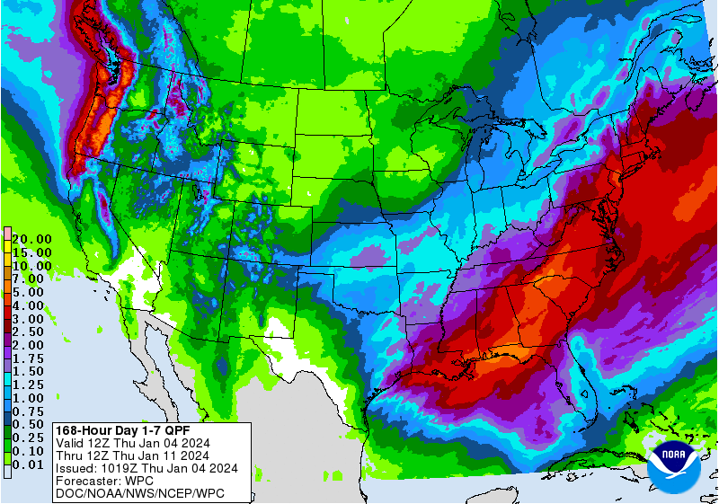
Two Mdt to high impact events NYC subforum; wknd Jan 6-7 Incl OBS, and mid week Jan 9-10 (incl OBS). Total water equiv by 00z/11 general 2", possibly 6" includes snow-ice mainly interior. RVR flood potential increases Jan 10 and beyond. Damaging wind.
in New York City Metro
Posted
I remember a lot of this, and I remember the weather channel being stationed at the Tarrytown end of the Bridge.
Everything goes in cycles. I Think it’s important to add that we are running 3 to 5° above where we were in the 90s. This probably would’ve been a little snow event for New York City where now it’s raining.
Also want to throw out what somebody else was saying, this really isn’t that marginal of an airmass. Certainly better than anything we have had recently or will have over the next week.