

SENC
-
Posts
892 -
Joined
-
Last visited
Content Type
Profiles
Blogs
Forums
American Weather
Media Demo
Store
Gallery
Posts posted by SENC
-
-
2 hours ago, Cold Rain said:
Skies are going to break again this weekend. What are the birds saying?
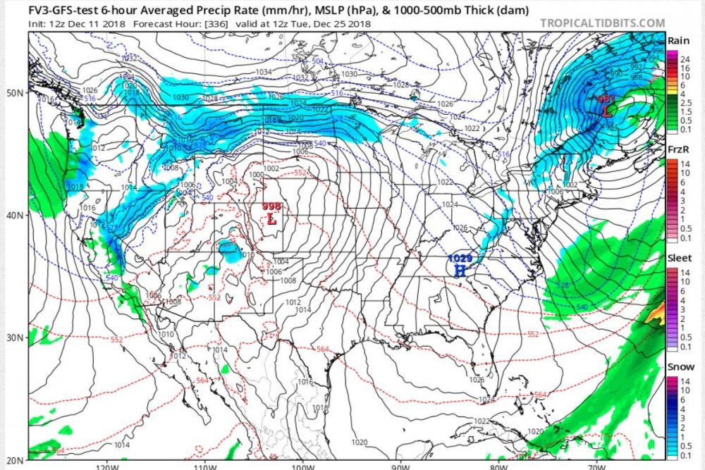
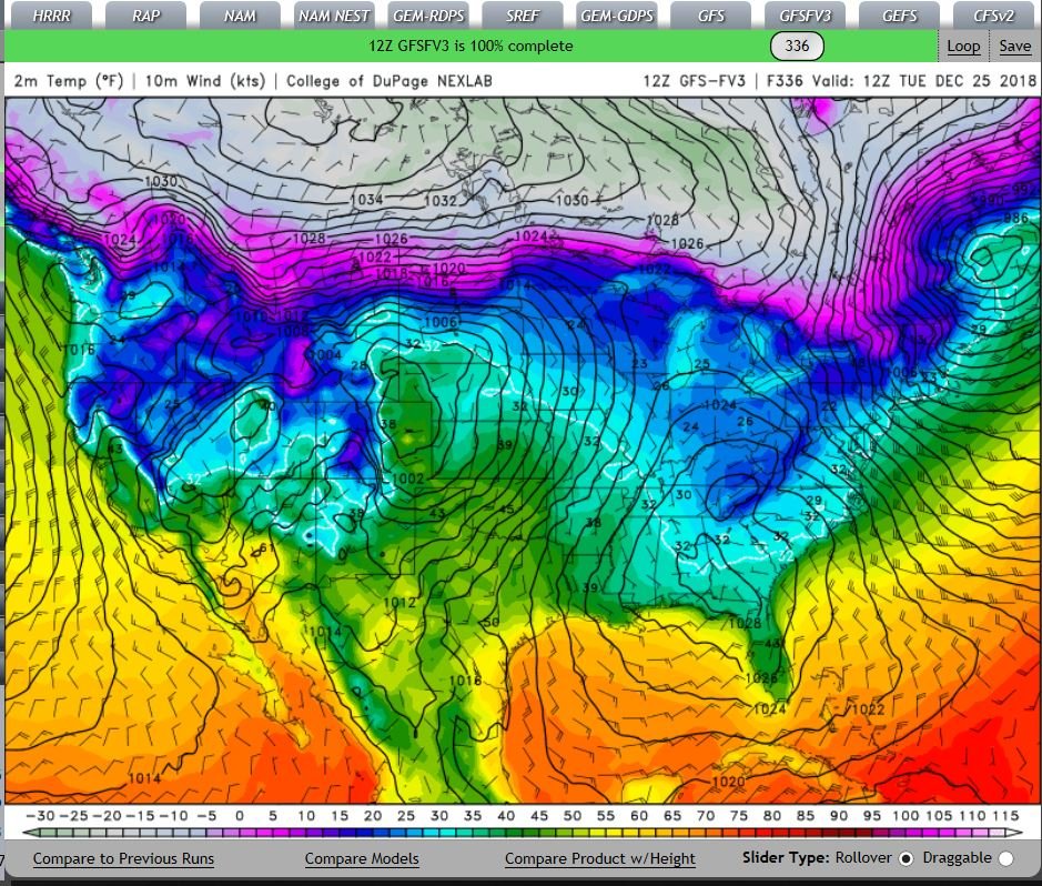
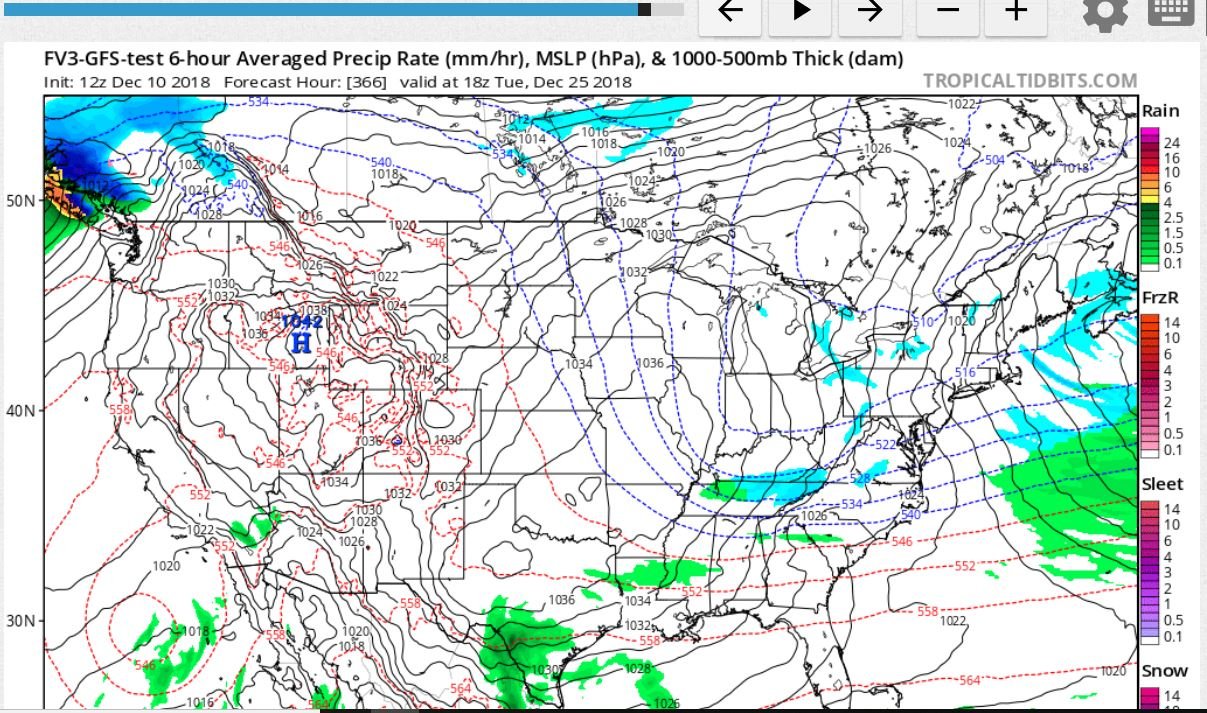
What does the "Fox" says?.. GFS-FV3..
-
4 hours ago, FallsLake said:
You live in a good "zone". I remember you did well last year in that early January storm; whereas I got about an inch. Then we both did well in the late January storm. Folks south and east of Raleigh have missed out the last few years. I feel (in my bones) that's going to change this year; a coastal plain blizzard is in order.
Can I quote you on that? We'll see how this ages over time..


-
 1
1
-
-
Interesting look into Fantasy land

-
 1
1
-
-
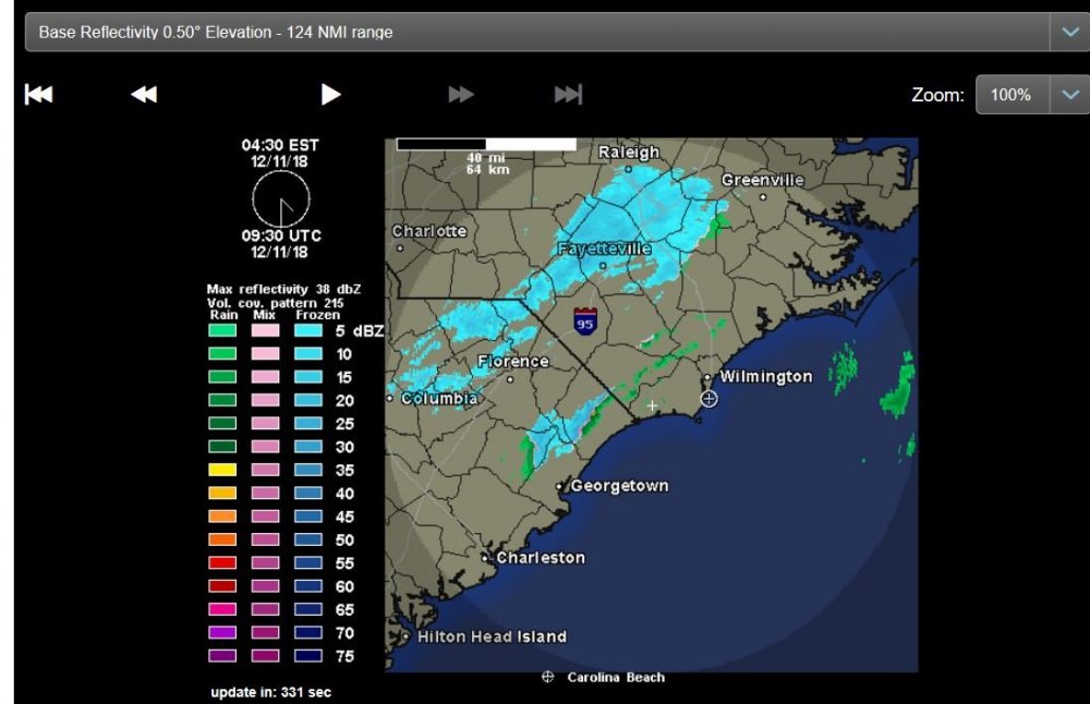
@Orangeburgwx, this round, ULL, petered out before it got here.. It did look promising..
My daughter, in Tabor City-Whiteville, did get a slight dusting..
Moister just, "ran out" before it got too my Local.. Maybe on the GFS-FV3 you can start that for the Dec 25th..(hinting,, looks exciting)!
-
21 minutes ago, Dunkman said:
That band is really picking up on radar hope it's snow for you guys!
Agreed, watching radar from ILM, the snow has been creeping south,, it's with-in 50 miles, of ILM.. Edit to add the radar returns are "blossoming" as it get closer to the coast..
35F DP of 31
-
21 hours ago, JoshM said:
Merry Christmas!

Well, the FV3-GFS is HINTING for something possible happening..

-
1
-
-
1 minute ago, Lookout said:
Took a long time but getting first flakes here too...rain/snow mix currently and 35. Radar isn't even showing returns over me at the moment.
Same here @Lookout, extreme light returns, though IT is SNOWING
 ..
..
currently 40 with a dew of 33.
-
I'm "experiencing" Extremely Light snow Flurries" ATM, Pixel sized flakes, But,, it IS SNOWING here in WILM!
-
4
-
 1
1
-
-
Believe it or not..
I'm getting extremely light SNOW Flurries! Pixel size flakes, though FLAKES & snow neither the less!
-
3
-
-
17 minutes ago, ncforecaster89 said:
Thanks... greatly appreciate the kind words! And, your own appreciation for the gift of a child. Eagerly look forward to each opportunity to see our baby girl, inside the womb, via ultrasound.
Given the developing El Nino, the probability of another significant winter storm in the SE, this winter, is certainly elevated. Will always choose my family over a prospective major weather event. That said, and as you articulated, there will be many more opportunities; especially since I'm willing to document them as far north as Maine.
Would share local storm effects from here in Wilmington, but SENC has got that covered, and the highlights consist of a very cold, wind-driven rain.
Thank you for the Kind words.. Wish I could report something other than wind driven Cold Rain though, it is, what it is living around ILM.. that's life..
I feel "Our" probabilities here in SENC & SC are Certainly, "elevated" to get a Wintery event over the course of this Winter..
Hope your "pregnancy" goes well for you & your Sig other on a healthy Girl..
-
1
-
-
@Orangeburgwx We just may get a second chance. (I saw a few big wet sloppy flakes about 5:30 am this morning, so theres that)…
Local AFD here. Concerning the ULL..
However
later tonight a deformation zone and or east to west 850-700mb
frontogenesis band develops within the complex mid level
pattern. This area will take up residence just along our
northern zones or close proximity to. Although deep moisture
will be limited, the dynamics of this feature will allow showers
and or areas of rain to develop moreso during the day Monday. I
don't expect anything heavy or any wintry precipitation, but
the extended duration of light rain and or showers could add up
to quarter to half an inch or so. Don't expect too much movement
in temperatures with the main storyline being much cooler
Monday as cold air advection behind departing surface low
pressure warrants. (lets hope things trend COLDER!)..The moisture profile is saturated through 15,000 feet and the
dendritic snow growth is at the top of this moisture. Rain with a
mix light snow are possible through the overnight hours Monday night
but no accumulation is expected. -
2 hours ago, downeastnc said:
The FV3, ICON and HRRR all have something similar to lesser degrees....temps will be a problem and overall it probably wont be a big deal but some models do put down a few inches....
Our Local NWS has this too say..
I think as this Storm overperformed the UUL will also?
QuoteHighs Monday should only reach the upper 30s
west of I-95 with 42-45 expected along the coast. Gradual and
nearly continuous cold advection should eventually make the
atmospheric column cold enough for a little light snow or sleet
to mix in with the rain along the back edge of the precipitation
shield Monday night as the warm nose aloft between 2000-6000
feet above ground level finally erodes away. No accumulations are expected,
but I wouldn't be surprised along the I-95 corridor or across
interior southeast North Carolina to see light mixed precipitation for
the final hour or two of the event. -
30 minutes ago, CoolBreeze said:
Yep, it's headed your way! Very heavy snow here now. Huge flakes, low visibility.
My friend up at/near Highrock Lake is reporting near Whiteout conditions ATM
-
Just chatting with My friend, Lives up by High Rock Lake, just south of Lexington, N.C. He says, He's got something like 8 inches and it's still, POURING snow there..
-
1
-
-
Just now, yotaman said:
Nothing but very cold rain here. 39/37 Congrats to those who have snow.
Same here @yotaman, @36F here, Wet-COLD & Fugly outside, thinking about a Steaming Pot of Chili today.. congrats to ALL upstate that cashed in! Post LOTSA Pictures!
-
Glad & Happy everyone "cashed-in" on this one, really enjoying the pictures so far..
Oh, so close for Us down here on the Coast.. Hopefully We can catch a "backside" Wiff.. Local NWS is calling for it later on..
-
21 minutes ago, shaggy said:
Same here I just measured 2 and a quarter on an elevated metal staircase. Never expected the flake size, duration and just heavy banding to setup over me. In fact I drove my wife's car to work instead of my truck because i never expected snow covered roads.
@shaggy & @Downeastnc eyeballing Radar, ya'll look to have yet another Super heavy band incoming..
Peeking outside for a bit.. See a "super heavy" Semi-melted Flake falling every now & then.. I think I've bottomed out on Temps setting @ 36F with a Dew point of 33F
Winds have "switched" to the NE now at 15 mph..
-
Oh My look at this Station report.. (Here in Wilmington.. )
Talk about that Amazing CAD!


-
@shaggy,, My Brother, just Messaged Me, He's reporting Rain/SN mixed.. He resides in Sneads Ferry, N.C., He's currently under a bright "yellow" band on Radar..
Looks like I'm about get a Dry slot here for a bit..
Temps have Crashed here to now 36F,, Talk about a temperature forecast BUST
Again that CAD is AMAZING!
Light Rain ATM
Still ENE Winds @ 13mph
-
My Daughter in Whiteville, (Columbus Co) just Messaged Me, She is seeing Flakes, huge ones.. (under the bright bands on Radar)..
-
Dern @shaggy My local nexrad radar shows you got ALL SN (and still creeping southwards towards Me)
-
Temps just fell another degree now at 38F/37 dew..
-
Temps are busting WAY on the low side Here in WILM!
Heavy rain rates off & on..
That CAD is AMAZING!
Doubt I'll see ANY Flakes, but My temps have crashed
From the "Forecasted 46F" overnight temps"
Temps have fallin to 39F dew point of 37F and still Falling!!!!!
Strong ENE winds @ 13 mph..
Watching the Rain/Ice snow line creeping south, about 75miles away from the coast!
-
1
-
-
Shades of the 2017, bust.. Just IMOP,(and I was rooting for ya'll!)..


2018 Banter Thread
in Southeastern States
Posted
@Solak, outta curiosity, I had to, I've never heard the "term" mentioned before either.. So, I looked it up..
corfidi vector
A procedure for operationally predicting the movement of the meso-beta scale convective elements responsible for the heavy rain in mesoscale convective complexes is presented. The procedure is based on the well known concepts that the motion of convective systems can be considered as the sum of an advective component, given by the mean motion of the cells comprising the system, and a propagation component, defined by the rate and location of new cell formation relative to existing cells. These concepts and the forecast procedure are examined using 103 mesoscale convective systems, 99 of which are mesoscale convective complexes.
https://www.spc.noaa.gov/publications/corfidi/mccthes.htm
Corfidi Vector
The "Corfidi Upshear" vector is an estimate of net storm motion for a "backbuilding" MCS, where the low-level storm inflow is subtracted from the mean wind. The "Corfidi Downshear" vector is an estimate of net storm motion for a "forward propagating" MCS where the low-level storm inflow is added to the mean wind.
https://www.weather.gov/grb/meso_help
So I "assume", by the RAH Disco means, "Multiple" Training rainfall/Precipitation "events" due to interaction of MESO convective complex (storm(s)) interacting with the Upper Level Jet influence? Just My non-educated guess...
Oh NOW, I see, Reading Comprehension problems on My behalf this afternoon, ( Had a Late/morning ALL nighter, still on My first Cup O' Joe)I see Why you underlined the Upper Level thing..
Edit too add, everything I've read has to do with a Low Level Jet, I'm Missing something, here...?? Hence yours (and our confusion?) Is it a Typo?