

SENC
-
Posts
892 -
Joined
-
Last visited
Content Type
Profiles
Blogs
Forums
American Weather
Media Demo
Store
Gallery
Posts posted by SENC
-
-
just WOW...
-
from that feed..
-
3 hours ago, Subtropics said:
Welcome to the forum. You're a legend for riding out Florence when it was progged to be a Cat 5 and you live on the beach.
Thank You! for the warm Welcome! Next 'Cat5" I'll still be "living on the Beach" to greet the next one!
-
 1
1
-
-
Tornado Watch..
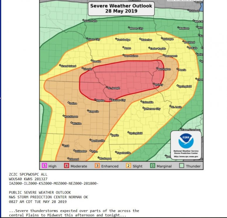
URGENT - IMMEDIATE BROADCAST REQUESTED Tornado Watch Number 274 NWS Storm Prediction Center Norman OK 145 PM EDT Tue May 28 2019 The NWS Storm Prediction Center has issued a * Tornado Watch for portions of Western New Jersey Extreme east central Ohio Pennsylvania The extreme northern West Virginia Panhandle * Effective this Tuesday afternoon and evening from 145 PM until 1000 PM EDT. * Primary threats include... A few tornadoes possible Scattered large hail likely with isolated very large hail events to 2 inches in diameter possible Scattered damaging wind gusts to 70 mph likely SUMMARY...Scattered severe thunderstorm development is expected this afternoon from Ohio into Pennsylvania, and storms will spread generally eastward through this evening. The storm environment will be favorable for supercells capable of producing large hail and damaging winds. A more favorable environment for tornadoes is expected across northern and eastern Pennsylvania into western New Jersey as the low levels destabilize. The tornado watch area is approximately along and 60 statute miles north and south of a line from 40 miles west southwest of Franklin PA to 35 miles north northeast of Trenton NJ. For a complete depiction of the watch see the associated watch outline update (WOUS64 KWNS WOU4). PRECAUTIONARY/PREPAREDNESS ACTIONS... REMEMBER...A Tornado Watch means conditions are favorable for tornadoes and severe thunderstorms in and close to the watch area. Persons in these areas should be on the lookout for threatening weather conditions and listen for later statements and possible warnings.
-
1
-
-
I posted in the Lakes/Ohio Valley region..
So I'll post'em on thisside to..
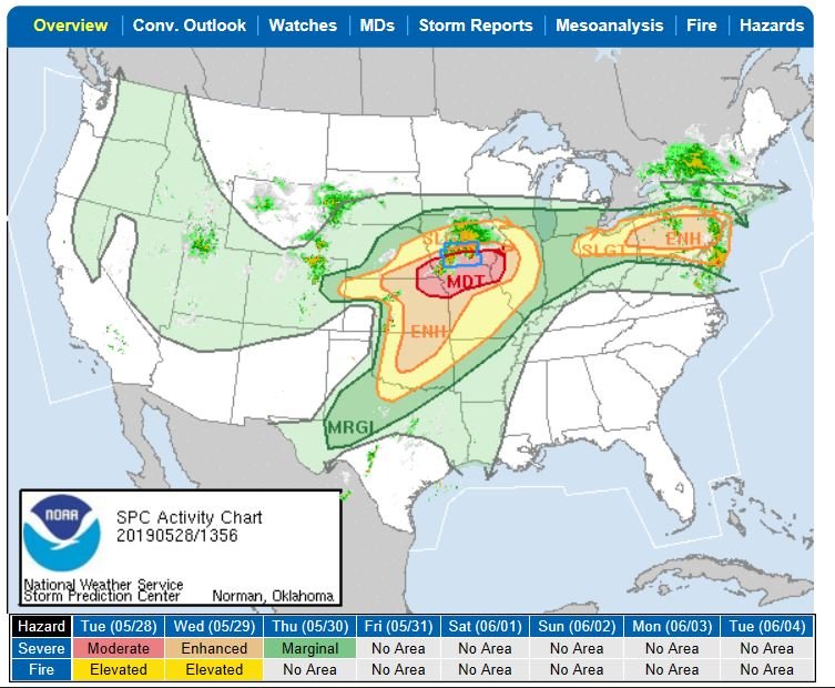
Looks to be a productive Day? For sever Wx?
-
 1
1
-
-
Sincerely hoping I'm posting this ok..
SPC outlook..
-
74/70
Dew 67.3
Humidity 81%
SSE Winds 10 mph
Temps are warning up, Along with the Humidity..
Dry here also.
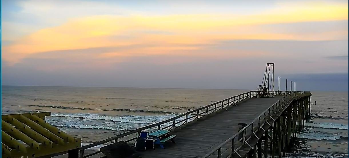
Water Temps is 70..
Plenty of Blues & Spanish being caught, making strong Spring Run Showings..
First 3 King Mackerel, from a Pier in 2019 have been caught.

-
Horry Chit the down pours! High Winds! OK April Showers bring MayFlowers..
")
-
We are FAR from outta the woods Folks! Sun is FULL out here in SENC..
Winds are STEADY 30+ gusting 40 MPH now with full sun overhead..
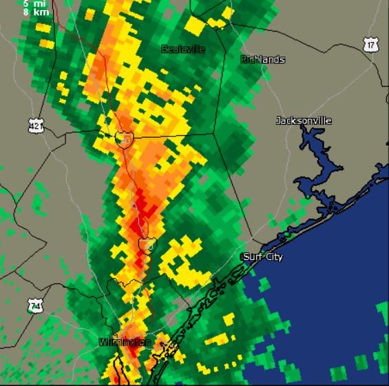
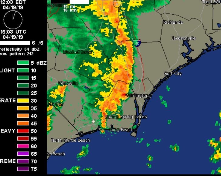
Those "storms" back by Charleston/Georgetown, SC, by the time that line gets here in a couple hours? Radar is LIT-UP
-
Squall line is just to My Immediate South & West by a few miles.. I think it's going to "clip" New Hanover county..
Winds steady @ to SSE 21~ gusting to over 30- mph...
What I FIND INTERESTING<< THE "convectively " <sp> ,, from these storms, start happening, When these Storms come on Land from the cool ocean waters, water Temp is 65 Blowing up as the come over the NOW HEATED Atmosphere over land, interesting watching the Radar..
Peaks of Sun has driven up temps from the Low-Mid 70's too now almost 80F in the past 1/2 hour..
Dewpoints in the high 60's with Humidity in the 90's
-
Afternoon folks, waiting on that first squall line to cross into My County area(s) down here in SENC, pretty gusty winds ahead of it..
-
Brad is Bloggin Live right now tracking someStorms..
Brad Panovich Meteorologist is live now.
26 mins · -
Under a active Tornado Watch..
THE NATIONAL WEATHER SERVICE HAS ISSUED TORNADO WATCH 68 IN EFFECT UNTIL 2 AM EDT MONDAY FOR THE FOLLOWING AREAS IN NORTH CAROLINA THIS WATCH INCLUDES 6 COUNTIES IN SOUTHEAST NORTH CAROLINA BLADEN BRUNSWICK COLUMBUS NEW HANOVER PENDER ROBESON IN SOUTH CAROLINA THIS WATCH INCLUDES 8 COUNTIES IN NORTHEAST SOUTH CAROLINA DARLINGTON DILLON FLORENCE GEORGETOWN HORRY MARION MARLBORO WILLIAMSBURG THIS INCLUDES THE CITIES OF ANDREWS, BENNETTSVILLE, BLADENBORO, BOILING SPRING LAKES, BURGAW, CHADBOURN, CONWAY, DARLINGTON, DILLON, ELIZABETHTOWN, FLORENCE, GARDEN CITY, GEORGETOWN, HARTSVILLE, KINGSTREE, LAKE WACCAMAW, LELAND, LITTLE RIVER, LONG BEACH, LUMBERTON, MARION, MCCOLL, MULLINS, MURRELLS INLET, MYRTLE BEACH, NORTH HARTSVILLE, NORTH MYRTLE BEACH, OAK ISLAND, RED HILL, SOCASTEE, SOUTHPORT, SUNSET BEACH, SURF CITY, TABOR CITY, WHITEVILLE, AND WILMINGTON.
-------------------------
Might as Well say the entire SENC, Northern? South Carolina Coast(s) for this..
Current conditions, We did have Ample amounts of Sunshine today..
currently 76.8 degrees..
Dewpoint-73F
Humidity @ 81%
Winds (currently) NORTH at steady, 20Mph gust(s) too 35 mph
Expected to veer outta the South/SW in a couple hours @ 15~25 MPH..
Ever get that Ominous feeling with the Weather? It feels NICE,, but...
Setting outside, peaks of sunshine, yet DARK Clouds building on the horizon?
-
…………...
-
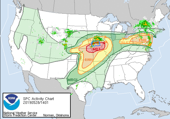
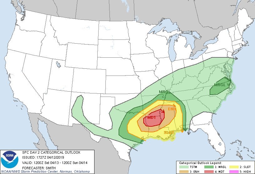
SPC just tweeted this..
-
Deep South, I know, though a MRGL in Central/Piedmont N.C.
Though look at that MDT!

-
I believe it's 'time" to let this thread die.. Hopefully Fall~Winter 2019~2020 will be much better..
God Speed Winter 2018~2019, We "believed" until...
-
Folks, I wouldn't "Give-up" on *Winter* until the Wilmington, Azalea Festival, As long as I've resided in the SENC. Always We get very cold, or Wintery Weather, (Sleet or Ice), by that Date. April 3rd~7th.. As long as I've lived here @ the Beach, oh, about the last 50 years.. (Very few "Warm" Festival(s) during My time residing here)...
That said,, What @jjwxman, posted, "could" trend colder..
In Our Favor..
-
Winter is DONE stick a fork in it..
Upstream Mid West Folks are Welcome!
10 reported tornadoes hit Arkansas, Louisiana as severe storms continue to sweep across country
https://abcnews.go.com/US/south-braces-tornadoes-severe-weather/story?id=61574545
-
2
-
 1
1
-
-
Shouldn't We have a "general" Severe Weather thread? Winters done,, stick a fork in it..
80F, partly cloudy Skies today.. here in SENC..
-
On 2/26/2019 at 7:42 AM, chubbs said:
Very unlikely that the warming in the southern oceans over the past couple of weeks has anything to do with upwelling. Expansive Hadley cells a more likely explanation. Note that fresh water from Antarctica ice sheet is just starting to ramp-up and will take centuries to play out.
Maybe underwater Volcanos Or Geologic activity such as, (Movement of the Earths Magma), might play a role?
-
On 2/19/2019 at 1:08 PM, Vice-Regent said:
Que the crimes against Earth becoming crimes against Humanity but only when it's far too late. I have concluded that climate change is not included in the umbrella of progressive causes. Why I am so adamant when criticizing democrats who have used this topic as an election platform.
Therefore doing even more damage by souring climate change by affiliating themselves with the problem without careing much about the dire implications.
Only "crimes" being committed are the Crimes against humanity, pushing a False agenda, RE: the Gol(BULL) Warming hoax.. @Vice-Regent, do Me just ONE lil favor.. Watch the ENTIRE video I posted above this post. Then, THINK for a few minutes, Then get back too us.. YOU even ADMIT your NOT a scientist or Academic. I wouldn't put My Life-Savings & "Faith" into Charlatans, that these So-called folks calling themselves, "climate " scientists..
Follow the money..
Look I'm a "old guy".. I was once a idealistic, "save the Earth" person also, scared that "Were all gonna die"! In My teens & 20's, lead on by so-called "alarmists",, (Peak Oil),, only to find out it's a bunch of Horse $_____.....
-
So much Cow Flatulence, Seriously!!
When are you folks going to realize, YOU have been Had!
Here is a video, of a collection of News Articles & papers going on about "Climate" since the 1950's..
When I was growing up, the Alarmism then was Peak Oil..
The So-Called Greenhouse Gas Effect
The China syndrome..
The Population Bomb..
Oh well,, We are all DOOMED,, Were ALL Going to Die!
Droughts, Blizzards, Hurricanes & Typhoons, Droughts & extreme Flooding, Because of the Earth COOLING
Seriously!!
Watch this video... Use your BRAIN GUYS..
-
I'm at 32.01 and rain, meanwhile, 5 miles away..

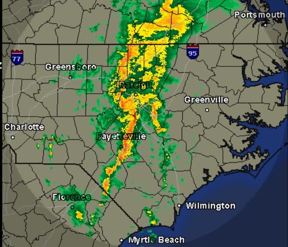
Mid to Late May 2019 Severe Threats
in Central/Western States
Posted