

SENC
-
Posts
892 -
Joined
-
Last visited
Content Type
Profiles
Blogs
Forums
American Weather
Media Demo
Store
Gallery
Posts posted by SENC
-
-
Positive Thoughts
Let's try a Off-Sides Kick
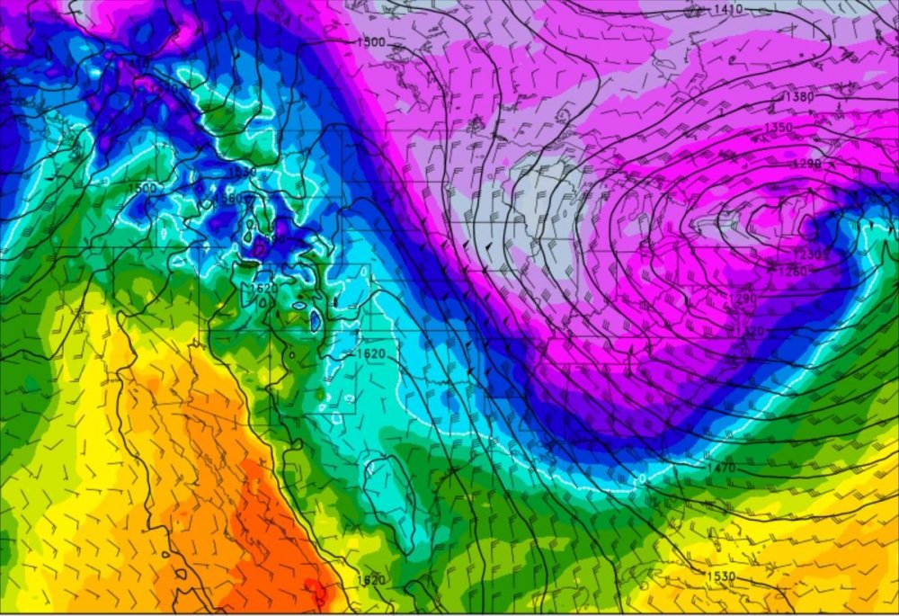
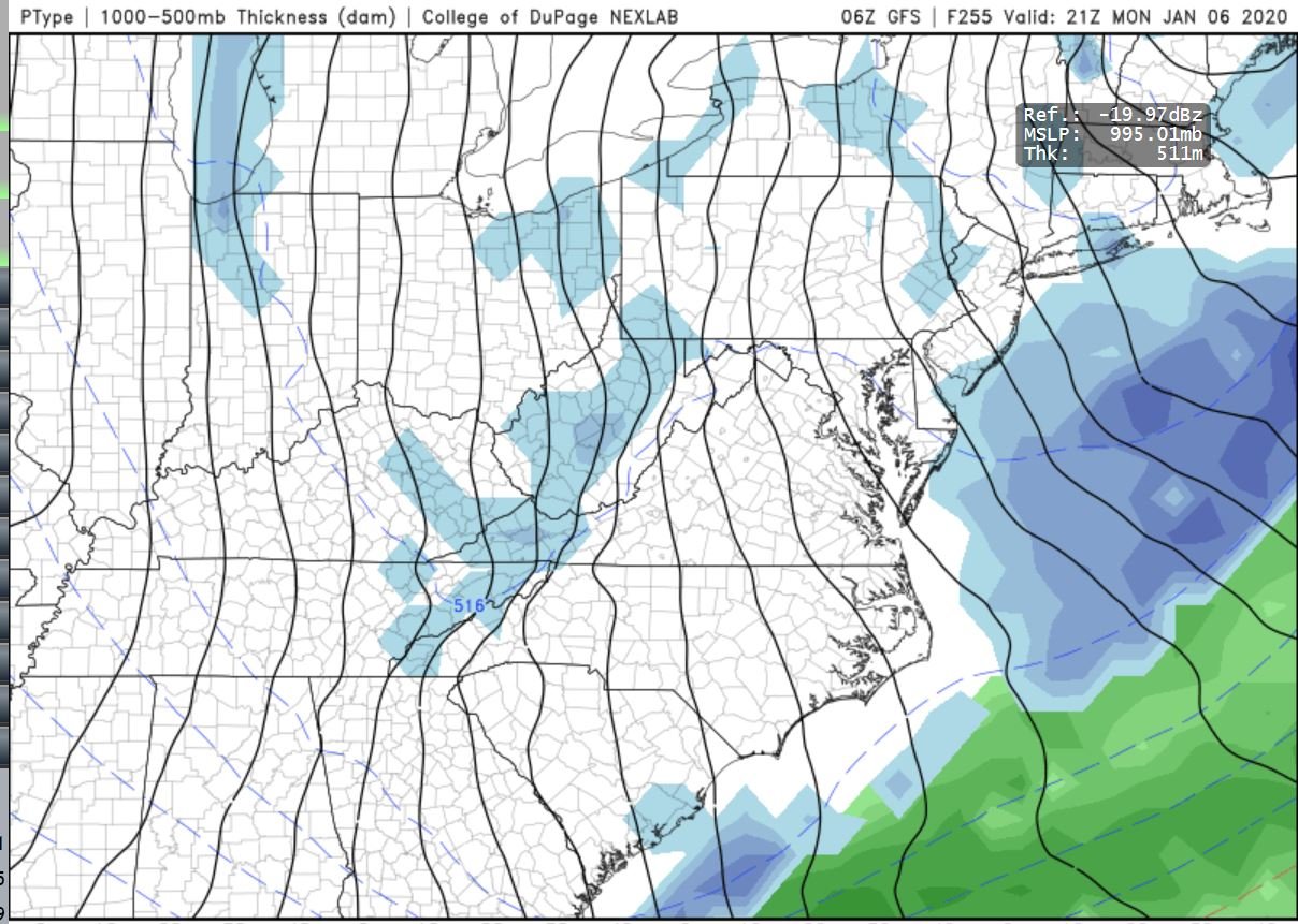
00ZGFS & the 12Z (well somewhat), continues to show some "impressive"? Cold air in the 240hr range (Jan 6th-7th timeframe..)..
A Couple ensembles show a Possible "Big Dog" for ya'll Mid-State, Most nothing at all, and a couple panels showing a "paste Bomb" for the Immediate Coast..
So Let's try a Off-Sides Kick..

Have the "Cold Air" in place, Develop a "LP" in the Southern Jet, The piece that WOW say gets left behind, (Yes the Models are "hinting" on that..) the same southerly Jet, Orangeburg says it's "In Da Keys"..
Wish for a slight NE trend.. Alil "Suppression" and *Not a lot*..
At least We'll have "something" to work with..
We just might Be in Bidness.. Either Warm-nosed out here on the Coast, or a paste Bomb, or a REAL Cold rain..
(I don't care on the outcome),,
Maybe ya'll will get something outta that, It's about the ONLY chance seen the past few weeks..
Something too watch for & keep a Eye on..

-
On 12/24/2019 at 12:46 AM, Iceagewhereartthou said:
Not much to to look forward to at this point, I'm punting the first half of Jan I guess, and I don't get too many punts after that or its over.
We need a couple of Off-Sides Punts! That'll save us!
-
 1
1
-
-
Love me some, Herp Albert..
The "Torch" shall continue...
The 18Z GFS throws a bone for a great cold shot in the 252 hour range, If that comes to pass & We can get a Coastal Low, We might be in business..
-
1
-
-
53/70 today..
Absolute AWESOME Sunny Day!
Here on the coast!
Looks to the same, If not warmer here on the coast tomorrow..
-
Low of 39F,, Today high of 50F
Nice sunny Christmas Day..
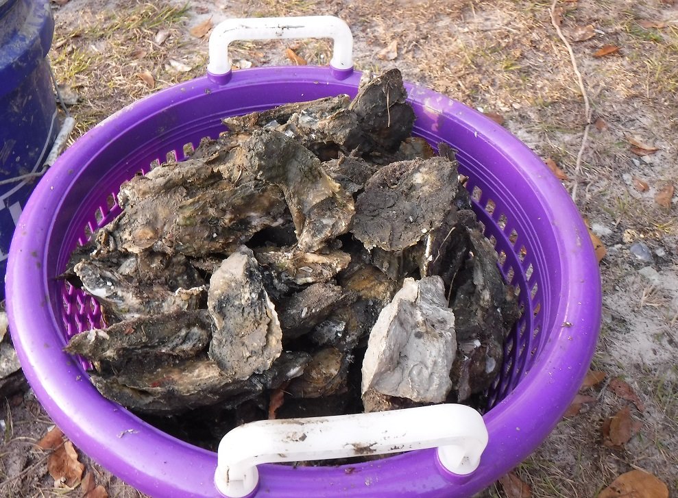
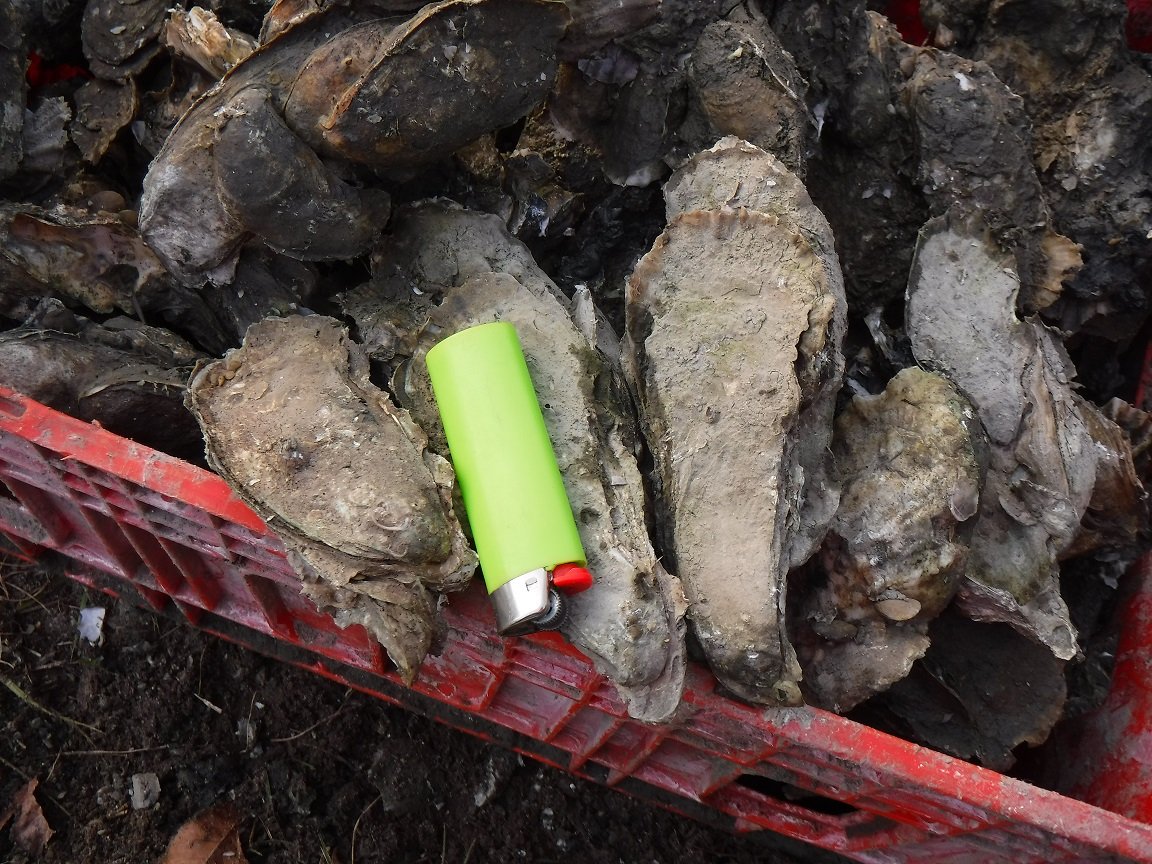
Went out for a hour got these for this evening..

-
3
-
-
Busted on the high side this Morning.
Forecast Low was supposed to be 29..
Clouds Moved into the SENC overnight..
Low of 39, this chilly Morning & Sea Fog..
-
Made it down too 26 this morning..
Again Fooking Cold..
3 dogs & a Cat in bed with Us...
Currently 40, expect High to day, about 53..
-
35 on the Coast, It's fooking cold.. (No Heat)..
-
Love ya';; folks, I'll enjoy My Low-Mid 40's & cold rain.. And.... Oysters..
I hope ya'll cash-in right before Christmas..
That said WOW! The Severe Weather deep south.. Tornado's in Dec? How common is that?
ya'll Hollar at Me when We see this set-up..
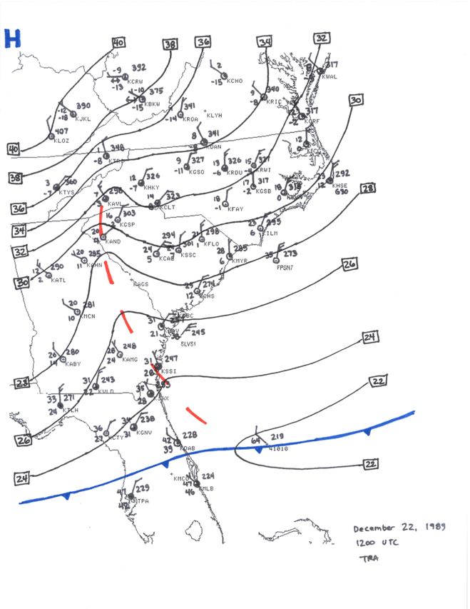
heres the Story, We are "due" for something like this too possibly happen again..
It IS/WAS a interesting set-up.. https://www.weather.gov/ilm/christmassnow1989
Wishfull thinking.. (I know),, I recall quite a few "older" folks opine that from Raligh, you could "see" the Darkened Could to the South, towards the Coast as this was happening..
It has been noted that in most significant snowstorms for the eastern Carolinas the surface low tracks very near 32° north latitude, 75° west longitude, about 215 miles southeast of Cape Fear.
-
Reporting from "Rich's" Inlet.. (Scotts Hill on the ICW)
Partly Cloudy..
BUT with HEAVY Dense FOG, (Sea Fog)..
Wind(s) North @ 2mph
Pressure 30.02
Temp 57F
DP 61%
Humidity 100%
Surf must be pretty Signicant, I can hear it "pounding" all the way up here on "Da Hill"..
Side Bar
SurfChex is reporting these "Wind Gust's"..
 Today's peak wind gust169 mph @ 3:18PM
 -
Down here on the *sound*, re; Rich's Inlet....
Winds steady 17 MPH Gusting over 35Mph..
Temp 48.0 ,, .06 in the bucket today.. Wind(s) are "howling",, I can hear the Surf pounding up here from INSIDE Muh house.. yikes!
-
Ocean Effect snow upcoming? I've seen this before here on the Coast..
-
Drunk & on crack..
-
My *new* address..
Scotts Hill - KNCWILMI137
-
97 currently @ the beach, (topsail) I've moved folks..
-
All due respect @donsutherland1,, I caught NSW (National Weather Service) .. Lying on "wind Speeds" & gusts here in Wilmington.. Does NOAA LIE? In My no uncertain terms,, yes..
-
4 hours ago, Indystorm said:
And now for an agency like NOAA to put politics ahead of science is infuriating.
I'm ashamed that NOAA AND By extension, the NWS, were in fact LIEING too the General Public, about Wind *Gust(s)* here in Wilmington/Carolina Beach & Federal Point areas.. ..
I'm Ashamed that NOAA tossed their .10 cents into the Ring of Global Warming Hoax, "Climate Change" debacle..
YES TRUMP was Right ..
Am I defending the President? NO though HE was in fact,, RIGHT, Get over it..
-
 2
2
-
 1
1
-
 3
3
-
-
Now Moderate Rain Squalls/ TS force winds in these Bands coming through..
Sustained 35 mph ……
gusts--> 40
-
Same as @downeastnc, Squalls moving through,, Winds have picked up just short of TS sustained,, 30 mph.. NO rain though,,, (yet)..
-
1
-
-
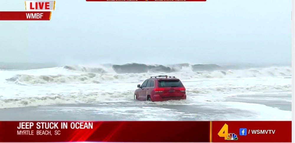
29 minutes ago, lilj4425 said:
RIP Jeep Grand Cherokee.
Mean this one?
-
2
-
-
-
25 minutes ago, Solak said:
Those Wind readings are VERY suspect, as in FALSE! We haven't had ANY *GUSTS* over 35 mph.. (exception for the Tornadic spin-ups).. Weather stations on the beach front haven't recorded anything over 23 mph..
-
1
-
1
-
-
Here @ the beach, breezy & light rain.. LOTSA Tornado warnings.. A very humid 79,, gust(s) from the North..
-
Good Morning Folks, woke up around 4AM w/my phone screaming Weather alerts..
Tornado warnings.. Or Waterspouts..
Looks like it's going to be a interesting morning & Day around ILM..
I sincerely believe, watching the course this morning, ILM will brace for Impact..
-
1
-


Mid to Long Term Discussion 2020
in Southeastern States
Posted
12Z Continues to show that Impressive "Cold Shot"..