

bubba hotep
-
Posts
2,665 -
Joined
-
Last visited
Content Type
Profiles
Blogs
Forums
American Weather
Media Demo
Store
Gallery
Posts posted by bubba hotep
-
-
The models have been toying with dragging a weak disturbance through just behind the arctic front. The 12z Euro is back on this but keeps most of the snow off the west of DFW. The 12z Euro EPS has about 2/3 of the members with some variation of this impulse and a good bit get snow into DFW. It looks like the disturbance that the Euro is sniffing out is out in the Pacific north of Hawaii. The strength and timing of that still need to be pinned down and the orientation of the trough associated with the arctic blast needs to be worked out. Maybe something to watch finally?
-
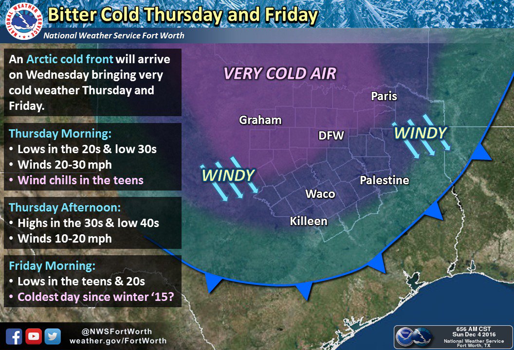
FWD sounding pretty bullish on the cold and going for 20 at FWD:
Winds will lessen Thursday night and Friday morning as surface
high pressure becomes centered over southern OK. Light north winds
will be in place, and with clear skies and very dry surface air
(dewpoints in the low teens), favorable radiational cooling should
cause temperatures to plummet. Have drastically undercut guidance
once again on Friday morning with my only fear being that I didn`t
go cold enough. Current forecast lows at DFW and Waco are around
20 degrees which would be the coldest temps since January 2015.
-
00z Euro came in colder than 12z and has area wide sub-25 lows with teens in the colder areas Thursday night. Then it has the northern burbs flirting with sub freezing highs on Friday.
Here is the latest from FWD:
-
5 hours ago, raindancewx said:
I gotta tell you guys, for the last week or so the La Nina has looked pretty ragged. It's too early to know, but I think it peaked in SON. Will be interesting to see the value for that period on Monday.
The years with La Nina or La Nina ish conditions in SON that then weakened ("warmed") by DJF since 1930 are:
1931, 1947, 1956, 1964, 1971, 1978, 1983, 1989, 1992. Three of those years come up a fair amount in temperature/precip trends this year in my area - 1978, 1983, 1989. Also, 1931, 1956, 1964, 1971, 1978, 1983, and 1992 - all either immediately followed or preceded an El Nino, so that's kind of interesting to think about in terms of the interference to La Nina / La Nina-ish conditions.
I used <=-0.2C in SON in Nino 3.4, followed by a warmer reading in Nino 3.4 in DJF as my thresholds, and I threw out the years that were <=-1.2C in SON, since this is a much weaker event.
It's actually an average to pretty wet pattern for everyone but California & Maine.

Yea, I've been noticing that. We could be talking about a "snowy" El Nino winter again next year?

-
Nothing overly interesting on the 12z Euro EPS. It looks like we might move pretty deep into Dec without any winter weather to track in the DFW area. On the bright side, the 12z GEFS doesn't seem to support the GFS and the mid-70s...
-
Not much rain over the past 24 hrs, this event is starting out kind of bustish, about 0.25" so far.
-
The last couple of runs of the Euro appear to be teeing up another Arctic blast. Maybe this one will be colder or deliver snow?

-
The 00z Euro looks to be trending to a "warmer" solution for next week with this outbreak looking a lot like some of the others from the past couple of seasons. The heart of the cold stays off to the NE vs diving straight down the spine of the Rockies. I guess on the bright side, the GFS has backed off the mid-month 70s?
-
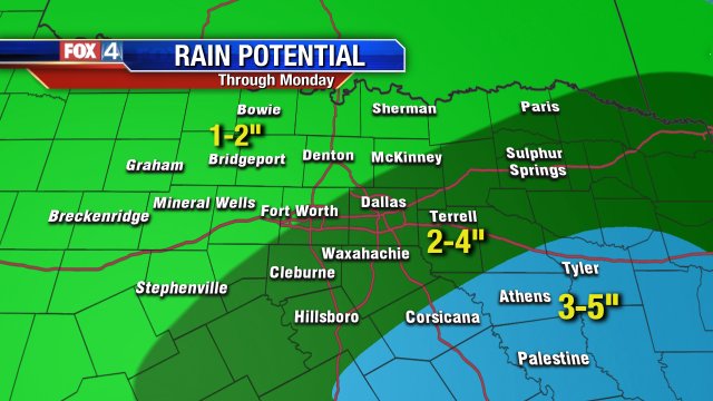
There hasn't been much talk about this weekends rain event but this seems like a pretty reasonable prediction, I probably would've gone 3-5"+
-
44 minutes ago, aggiegeog said:
It sounds like some of the Euro ensembles have a winter storm with the front. If we get snow or ice then the first single digit code in a very long time is possible. Red River counties could flirt with 0. Man I am getting excited.
The 00z Euro EPS backed way off on the snow chances vs. 12z. Only one member shows anything for DFW next week.
-
The new Euro weeklies show above normal precip and below normal temps for Texas through mid-Jan.
-
14 minutes ago, aggiegeog said:
18Z GFS continues idea of light snow at least along the Red River Wednesday morning right behind the front. By Thursday it has a 1041mb high over N TX. With these two things I think it is underdoing the lows Thu and Fri as it shows mid to upper 20s with DPs in the teens with a very light wind going calm.
It looks like 7 of the 15 Euro EPS members that show snow are with the first impulse that was on the 00z Euro and the 12 & 18z GFS.
-
12z Euro EPS with one of the "snowiest" looks so far this season w/ 15 members showing measurable snow at DFW. The mean is 0.5" but a couple of members pushing 4".
-
Just now, DFWWeather said:
12z ECMWF came in colder back to the -9°C. If that holds, I wouldn't be surprised (presuming excellent radiational cooling setup) if DFW Airport doesn't make a run for the upper teens. The ECMWF is bone dry.
It look like teens would be a lock for the northern burbs with that setup.
-
12z Euro looks chilly, has the northern burbs of DFW with sub freezing highs next Thursday.
-
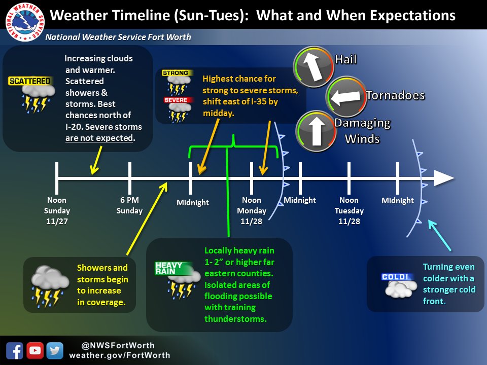
Pretty strong signal that a good portion of our subforum will see soaking rains:


-
Nice to see some over performing cold. Last time I looked at my NWS point forecast yesterday it had a low of 37. Right now - 31!
-
18z GFS has temps in the 70's by mid-Dec... not a chance of snow to track on the models...

-
On 11/29/2016 at 7:32 PM, raindancewx said:
Do any of you like 1978-79 as an analog? It was a borderline La Nina (-0.4C) in Fall of 1978, but it weakened to Neutral in winter. It followed two El Nino winters (76-77, 77-78), and occurred after a reversal in the long standing sign of the PDO (1976/2013 - although the more recent flip seems to be a spike more than a 30-year flip). I ask because the La Nina seems to be weakening, we're following two El Ninos...and the cold experienced in the US in January 1979 (-8F to -20F over most of the US) has been occurring over Asia for the past two months.
January 1979 was stupid cold in the middle of the country - including TX, OK, etc.
What does the Pacific as a whole like for that year? The MEI is a decent match but the PDO doesn't look like a very good match.
-
-
1 hour ago, DFWWeather said:
Today's 0z ECMWF is down to -8.5°C at H85 for the potential Arctic blast December 8th through 10th. If that were to verify, that would mean the coldest air at DFW in nearly 2 years. Which, of course, isn't saying much as the lowest temp all last winter was an unprecedented 27°F and we had no days below 40°F for highs. Who knows what is going on with today's 0z and 6z operational GFS. It seems to be odd with no Arctic air as the last several runs have had it.
12z GFS looks like it keeps DFW below 40 for the high next Thursday. It is a ways off but there is growing agreement across operational and ensemble models that DFW could see the coldest air in years with this shot.
-
1 hour ago, DFWWeather said:
Pattern starting to look interesting on 12z ECMWF for this weekend. Quite a bit colder than the 12z GFS, especially in upper levels. Looks like a raw, chilly, wet weekend with temps in the 40s for DFW for highs and lows in the 30s. Also, both the GFS and ECMWF are trending to what could be a bona fide Arctic blast by the December 10ish timeframe. ECMWF has nice little system with the cold air too on its D10! Could December tank like '83?
'83 is an analog that keeps coming up when I bounce stuff around. However, people on the Twitter act like only a true weenie would bring it up. One thing is for sure, the 12z Euro EPS keeps our source region below normal the entire run. That was our biggest issue last winter, there was no cold up there when the pattern did get favorable.
-
Looks like the main threat will be in E. Texas and Louisiana tomorrow but maybe some thunder for the norther burbs of DFW late tonight:

-
Looks like an active couple of days on tap:


Texas/New Mexico/Louisiana/Mexico Obs And Discussion Thread Part 8
in Central/Western States
Posted