

bubba hotep
-
Posts
2,665 -
Joined
-
Last visited
Content Type
Profiles
Blogs
Forums
American Weather
Media Demo
Store
Gallery
Posts posted by bubba hotep
-
-
SPC not thinking a watch will be necessary
MESOSCALE DISCUSSION 1225
NWS STORM PREDICTION CENTER NORMAN OK
0337 PM CDT SAT JUL 09 2016
AREAS AFFECTED...NORTH CENTRAL TEXAS
CONCERNING...SEVERE POTENTIAL...WATCH UNLIKELY
VALID 092037Z - 092130Z
PROBABILITY OF WATCH ISSUANCE...20 PERCENT
SUMMARY...STRONG WINDS WILL ACCOMPANY THE LEADING EDGE OF
THUNDERSTORM COMPLEX AS IT PROPAGATES INTO THE METROPLEX.
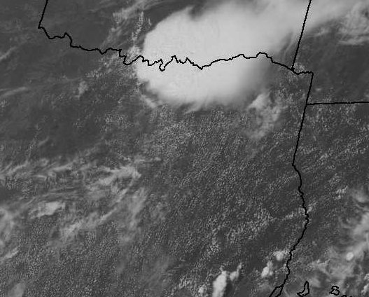
DISCUSSION...SLOWLY ORGANIZING CLUSTER OF THUNDERSTORMS HAS MIGRATED
SOUTH OF THE RED RIVER WITH LEADING EDGE OF HIGHER REFLECTIVITY INTO
THE NORTHERN MOST PORTION OF THE METROPLEX. THIS CLUSTER OF STORMS
HAS GENERATED GUSTS IN EXCESS OF 40KT NEAR THE RED RIVER AND
NEAR-SEVERE WIND GUSTS CAN BE EXPECTED AS HIGH PW CONVECTION
PROPAGATES WEST OF SOUTH INTO THE METRO. WHILE SFC TEMP/DEW POINT
SPREADS ARE NOT THAT GREAT...WATER-LOADING DOWNDRAFTS SHOULD
ENCOURAGE STRONG WINDS.
..DARROW/THOMPSON.. 07/09/2016
-
First SVR just issued and radar is showing some decent winds.

-
Radar and sat looking good for storms to maintain into DFW this afternoon
-
Can see some really nice cloud tops on those southern Oklahoma cells, they look to be maintaining or strengthening. That should allow them to develop a cold pool and start pushing southward towards DFW. HRRR seems to support this, so maybe some storms later?
-
Marginal expanded southward to include northern half of DFW for this afternoon
-
Even more of a chance?
-
So you are saying there is a chance?
-
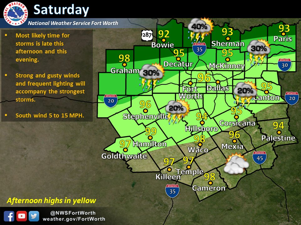
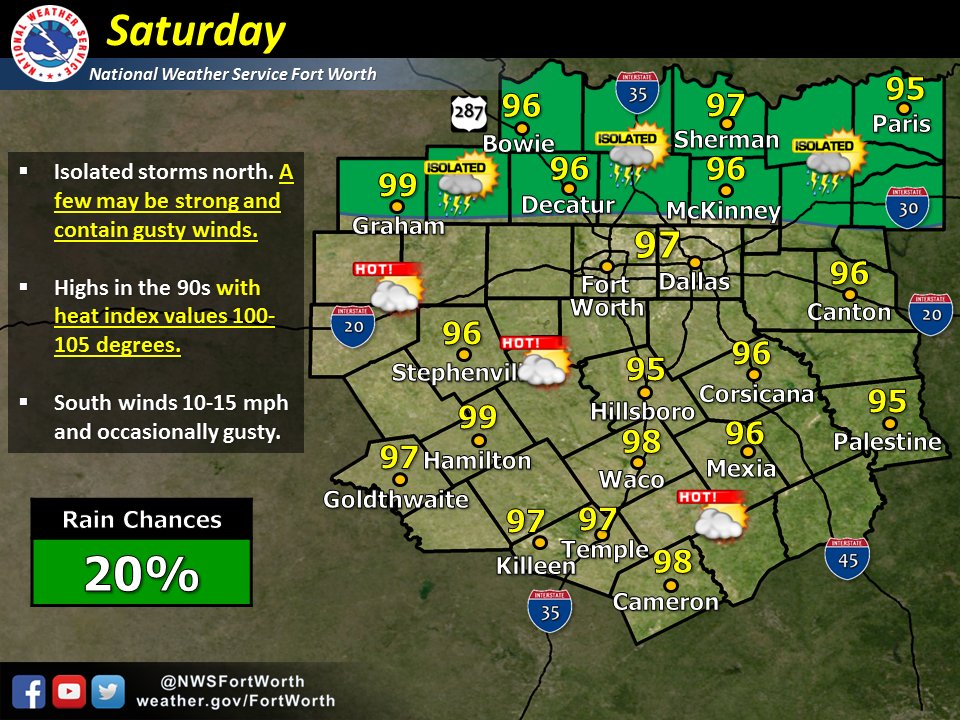
Looking at forecasts this morning, forecasters are really way overdoing the heat and not taking into account the rainfall. So many forecasts are even forecasting hotter temps than what the models are generating (which those usually don't take evapotranspiration effects into account). I don't see any triple digit readings at DFW Airport for the next 7 to 10 days. For one, the ridge really isn't all that strong, the winds are staying up keeping the boundary layer well mixed, and the record rainfall we have received are all working against triple digit heat. Everything is still quite green here due to the above average precipitation. Highs will continue to stay between 95 and 98 degrees. Yesterday's high was only 93°F and the low this morning 75°F well below what used to be the threshold of 78°F to maintain a Heat Advisory, plus heat index values stayed below 105°F yesterday. Coupled with the 71°F reading the prior morning, we are getting enough relief at night from the heat to forego any Heat Advisory. It could be so much hotter this time of year, and I really fell the heat is being blown way out of proportion.
The models have been too warm and too dry in the medium to longer range but eventually they will be right (it's summer in DFW after all
 ). The Euro EPS has been pretty constant with showing the first 100's for DFW around mid-month but even that isn't a slam dunk, esp. if we keep getting these sneaky rain events. Like you said, the ridge keeps under performing and hasn't been able to beat back the low level moisture. I wouldn't be surprised to see afternoon storms pop again over the next week or so.
 -
DFW ended up with 3.20" yesterday smashing the daily record and locking in an above avg monthly total.
-
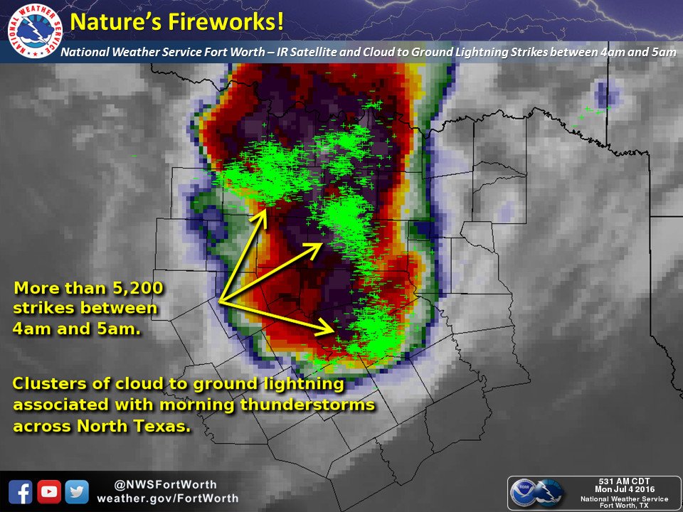
Some nice natural fireworks headed this way. Night into day!
 image.jpeg
Cool pic! The 4th of July went out with a bang for sure after working hard all day. We had that storm that came through just after midnight to get the day started, then storms first thing in the morning and then last night. All three were super energetic with lots of lightning.
-
A couple of random cells popping in the DFW area now, this one isn't too far away
ETA: It is setting off some big time fireworks now!

-
Keep moving just north of east but would like to see some expansion in coverage
-
If those randomly spastic moving cells can form a cold pool and start pushing east then we might get something with this setup

-
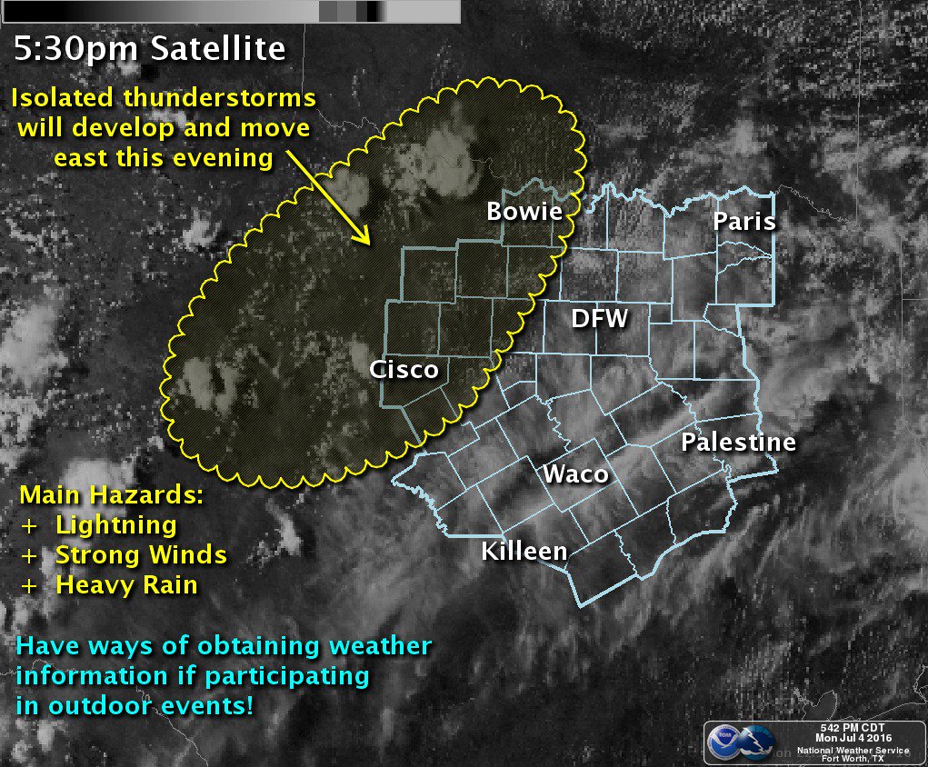
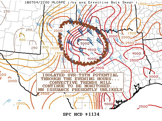
MESOSCALE DISCUSSION 1134
NWS STORM PREDICTION CENTER NORMAN OK
0521 PM CDT MON JUL 04 2016
AREAS AFFECTED...PORTIONS OF NWRN/N-CNTRL TX AND VICINITY
CONCERNING...SEVERE POTENTIAL...WATCH UNLIKELY
VALID 042221Z - 050045Z
PROBABILITY OF WATCH ISSUANCE...20 PERCENT
SUMMARY...ISOLATED TSTMS ARE EXPECTED TO CONTINUE DEVELOPING ACROSS
PORTIONS OF NWRN/N-CNTRL TX AND VICINITY THROUGH THE LATE AFTERNOON
HOURS INTO THE EARLY EVENING. ISOLATED INSTANCES OF SVR WIND/HAIL
MAY ACCOMPANY THIS CONVECTION. SOME OF THIS ACTIVITY COULD LINGER
WELL INTO THE EVENING. CONVECTIVE TRENDS WILL CONTINUE TO BE
MONITORED...THOUGH PRESENT INDICATIONS ARE THAT WW ISSUANCE WILL BE
UNLIKELY.
DISCUSSION...STRONG DIABATIC HEATING OF THE MOIST BOUNDARY LAYER
CHARACTERIZED BY DEWPOINTS IN THE LOWER 70S -- EXCEPT IN THE 60S
ACROSS PARTS OF THE HIGH PLAINS -- HAS FOSTERED VERY STRONG
DESTABILIZATION THIS AFTERNOON. SFC ANALYSIS AND VIS SATELLITE
IMAGERY IMPLY AN ASSORTMENT OF DIFFUSE OUTFLOW BOUNDARIES AND
CONFLUENCE AXES ACROSS THE REGION...ALONG WITH A FRONTOLYTIC
SYNOPTIC BOUNDARY INVOF THE RED RIVER...SERVING AS FOCI FOR
INCIPIENT CONVECTIVE DEVELOPMENT. ADDITIONAL ISOLATED CONVECTION
WILL LIKELY OCCUR ACROSS THE REGION DURING THE NEXT SEVERAL HOURS AS
MLCINH HAS MOSTLY ERODED. TSTMS SHOULD SPREAD SEWD THROUGH THE
EVENING HOURS.
HOWEVER...THE OVERALL DEARTH OF LOW-LEVEL CONVERGENCE SUGGESTS THAT
CONVECTIVE COVERAGE WILL LIKELY BE LIMITED. REGARDLESS...THE
COMBINATION OF THE AMPLE INSTABILITY AND A ZONE OF MODESTLY ENHANCED
MID-LEVEL FLOW SUPPORTING AROUND 30-45 KT OF EFFECTIVE BULK SHEAR
SUGGESTS THAT A FEW SUSTAINED/ORGANIZED CONVECTIVE ELEMENTS MAY
OCCUR WITH LOCALLY SVR WIND/HAIL. LARGE DCAPE WILL SUPPORT LOCALLY
CONSOLIDATING COLD POOLS WITH THE POTENTIAL FOR FOCUSED CORRIDORS OF
LOCALLY SVR WIND GUSTS...ESPECIALLY IF UPSCALE CONVECTIVE GROWTH
WERE TO FOSTER CONVECTIVE CLUSTERING.
PRESENT INDICATIONS ARE THAT CONVECTIVE COVERAGE AND THE ATTENDANT
SVR RISK MAY REMAIN TOO ISOLATED FOR WW ISSUANCE. HOWEVER...IF A
MORE ORGANIZED...FORWARD-PROPAGATING CONVECTIVE CLUSTER WERE TO
BECOME EVIDENT WITH GREATER POTENTIAL FOR SVR WINDS...WW
PROBABILITIES COULD INCREASE. THIS WILL BE HIGHLY CONTINGENT ON
STORM-SCALE PROCESSES WITH LIMITED PREDICTABILITY AT THE PRESENT
TIME...THOUGH THE AREA FROM THE LOW ROLLING PLAINS TO N-CNTRL TX W
OF THE DFW METROPLEX COULD BE A FAVORED AREA FOR CONVECTIVE-CLUSTER
DEVELOPMENT.
..COHEN/GUYER.. 07/04/2016 -
Cells starting to pop out near Wichita Falls again this afternoon, maybe they can ride the gradient towards DFW?
-
Record daily rainfall event at DFW this morning with more rain possible this afternoon. Could DFW end up with a months worth of rain in one day?
-
looks like 1.5" for a lot of the center of the metroplex. Spot 2" reports.
Also, seeing reports of wind damage in a few areas with gusts up towards 70 mph
-
Wow, just insane lightning this morning!
-
Think you've got a shot.
We got a decent hit right after midnight and look to pick up some more with this current batch of cells.
-
Legit early morning light show
-
Storms moving into western areas but not holding out hope out here in the far east. How many times this season have storms died west of I35? Far too often it seems like.
-
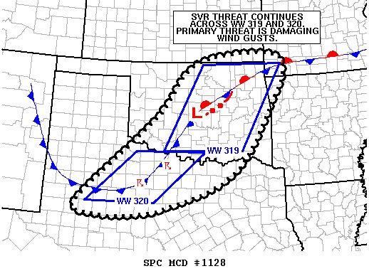
MESOSCALE DISCUSSION 1128
NWS STORM PREDICTION CENTER NORMAN OK
0749 PM CDT SUN JUL 03 2016
AREAS AFFECTED...CNTRL/ERN OK...NW TX...FAR SW MO...FAR NW AR
CONCERNING...SEVERE THUNDERSTORM WATCH 319...320...
VALID 040049Z - 040215Z
THE SEVERE WEATHER THREAT FOR SEVERE THUNDERSTORM WATCH
319...320...CONTINUES.
SUMMARY...SVR THREAT CONTINUES ACROSS SVR WATCHES 319 AND 320.
DAMAGING WIND GUSTS ARE THE PRIMARY THREAT BUT SOME ISOLATED LARGE
HAIL IS ALSO POSSIBLE.
DISCUSSION...RECENT RADAR TRENDS SUGGEST UPSCALE GROWTH INTO MORE OF
A LINEAR CONVECTIVE HAS OCCURRED ACROSS CNTRL OK...WITH COLD POOLS
FROM EARLIER CONVECTION AMALGAMATING AS THEY MOVE SEWD. MID-LEVEL
FLOW IS WEAK /00Z OUN SOUNDING SAMPLED AROUND 20 KT AT 700 MB/ SO
THE CHANCES OF A WELL-DEVELOPED...FAST-MOVING LINE ARE VERY
LOW...ALTHOUGH SOME LOCALLY STRONG WIND GUSTS ARE POSSIBLE IN AREAS
WHERE THE LINE MERGES WITH PRECEDING STORMS AND/OR PRECIP LOADING
LEADS TO A STRONG DOWNDRAFT. INTERSECTING OUTFLOWS ALONG THE SRN END
OF THE LINE WILL RESULT IN ADDITIONAL DEVELOPMENT...WITH A MORE
EAST-WEST ORIENTATION ANTICIPATED. FORWARD SPEED OF THE LINE HERE
WILL BE LESS THAN AREAS N AND E...PARTICULARLY AS THE LLJ
INCREASES...BUT A FEW DAMAGING WIND GUSTS ARE STILL POSSIBLE. SOME
BACKBUILDING IS POSSIBLE ALONG THIS PORTION OF THE LINE...WITH THE
RESULTING STORMS LASTING SEVERAL MORE HOURS. HOWEVER...THE
CONVECTION UPSTREAM OVER NW TX MAKES THIS SCENARIO UNLIKELY WITH
TSTMS EXPECTED TO WANE WITH DAYTIME HEATING.
FARTHER S /ACROSS NW TX/...MORE CELLULAR CONVECTIVE
CONTINUES...ALTHOUGH MOST OF THE STORMS ARE OUTFLOW DOMINANT WITH AT
LEAST SOME POTENTIAL FOR UPSCALE GROWTH INTO A CONVECTIVE SYSTEM
THAT WOULD THEN LIKELY TRACK SEWD TOWARDS THE METROPLEX. DAMAGING
WIND GUSTS ARE THE MAIN THREAT...ALTHOUGH SOME ISOLATE LARGE HAIL IS
POSSIBLE.
..MOSIER.. 07/04/2016 -
Updated D1 to account for trends this evening.
-
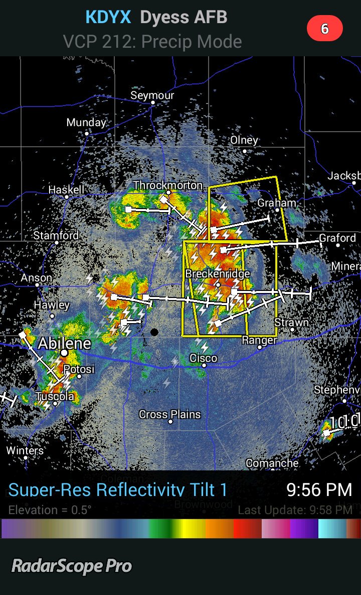
Storms are starting to really get going

Texas/New Mexico/Louisiana/Mexico Obs And Discussion Thread Part 8
in Central/Western States
Posted
Now warnings for most of the northern burbs but the eastern edge seems to be weakening a bit