

bubba hotep
-
Posts
2,665 -
Joined
-
Last visited
Content Type
Profiles
Blogs
Forums
American Weather
Media Demo
Store
Gallery
Posts posted by bubba hotep
-
-
-
Watching the area from Ardmore,OK back down to the SW and starting to see some signs of life.
-
There are some quirks with this new setup that bug me. Anyway, here is the graphic:

-
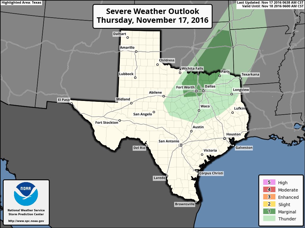
 MESOSCALE DISCUSSION 1822
   NWS STORM PREDICTION CENTER NORMAN OK
   0531 PM CST TUE NOV 22 2016

   AREAS AFFECTED...PARTS OF NORTH CENTRAL TEXAS INTO EAST CENTRAL
   OKLAHOMA

   CONCERNING...SEVERE POTENTIAL...WATCH POSSIBLE

   VALID 222331Z - 230100Z

   PROBABILITY OF WATCH ISSUANCE...40 PERCENT

   SUMMARY...A COUPLE OF DISCRETE STRONG TO SEVERE STORMS MAY DEVELOP
   ACROSS PARTS OF NORTH CENTRAL TEXAS THROUGH SOUTH CENTRAL AND EAST
   CENTRAL OKLAHOMA WITHIN THE NEXT COUPLE OF HOURS.  IT SEEMS MORE
   PROBABLE THAT A WATCH MAY BE NEEDED LATER THIS EVENING TO THE SOUTH
   AND EAST OF THE AREA CURRENTLY OUTLINED.  HOWEVER TRENDS WILL
   CONTINUE TO BE MONITORED.

   DISCUSSION...A SURFACE COLD FRONT IS READILY EVIDENT IN
   OBSERVATIONAL DATA ADVANCING SOUTHEASTWARD...AT NEAR 20 KT...ACROSS
   PARTS OF WESTERN OKLAHOMA AND NORTHWEST TEXAS.  AT THIS RATE...IT MAY
   BEGIN OVERTAKING THE DRYLINE...NOW WEST/NORTHWEST OF THE DALLAS/FORT
   WORTH METROPLEX INTO AREAS NEAR/JUST EAST OF THE OKLAHOMA CITY...
   TOWARD 01-02Z...WHEN FORCING FOR ASCENT MAY SUPPORT INCREASING
   THUNDERSTORM ACTIVITY AS IT ENCOUNTERS MODEST POTENTIAL INSTABILITY.

   LATEST GUIDANCE SUGGESTS THAT BOUNDARY LAYER WARMING AND MOISTENING
   HAS CONTRIBUTED TO A CORRIDOR OF MIXED LAYER CAPE UP TO 500 J/KG...
   AHEAD OF THE DRYLINE ACROSS NORTH CENTRAL TEXAS THROUGH SOUTH
   CENTRAL AND EAST CENTRAL OKLAHOMA.  IN THE PRESENCE OF THIS
   INSTABILITY...IT IT DOES NOT APPEAR OUT OF THE QUESTION THAT WEAK
   MID-LEVEL COOLING AND FORCING FOR ASCENT ASSOCIATED WITH LOW-LEVEL
   WARM ADVECTION COULD CONTRIBUTE TO DISCRETE STORM DEVELOPMENT IN
   ADVANCE OF THE ARRIVAL OF THE FRONT.  IF THIS OCCURS...VERTICAL SHEAR
   BENEATH 50+ KT CYCLONIC/SOUTHWESTERLY 500 MB FLOW PROBABLY IS
   SUFFICIENT FOR SUPERCELL STRUCTURES.

   LARGER LOW-LEVEL HODOGRAPHS ASSOCIATED WITH A 40 KT SOUTHERLY 850 MB
   JET ARE GENERALLY OFF TO THE EAST (JUST EAST OF DALLAS INTO THE
   OZARK PLATEAU)...WHICH SEEMS LIKELY TO LIMIT ANY TORNADIC POTENTIAL...
   AT LEAST INITIALLY.  HOWEVER...STRONGER DISCRETE STORMS MAY BE
   CAPABLE OR PRODUCING SEVERE HAIL AND LOCALLY STRONG SURFACE GUSTS.

   ..KERR/GUYER.. 11/22/2016
-
The 09z SREF pops a 45 Sig Tor Ing contour over the eastern 1/3 of DFW this evening.
-
Latest thinking from FWD:


-
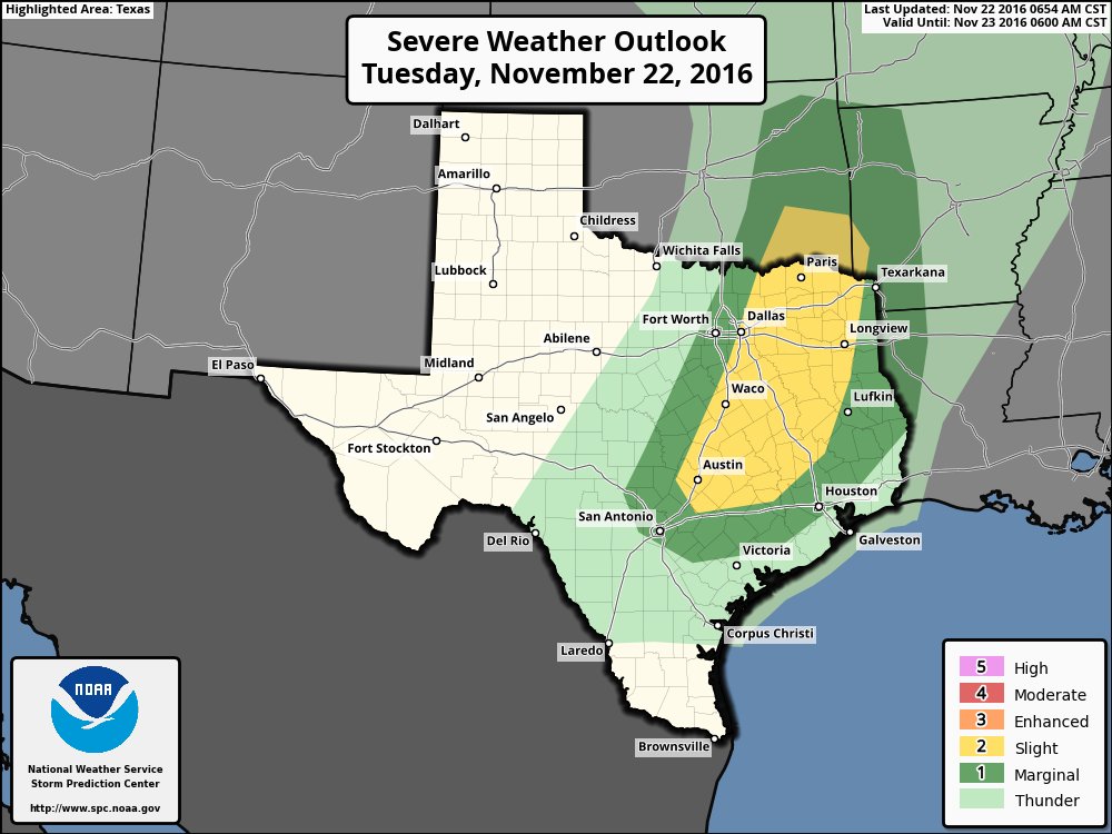
Most of the models keep storms east of DFW today but maybe we can score something out my way. The 00z WxBell Euro WRF is farther west with storms and seems to support the current SPC D1 graphic:
-
First fantasy snow storm for N. Texas on the 06 GFS!


-
On 11/18/2016 at 10:03 AM, bubba hotep said:
00z Euro EPS seems to support the Euro Weeklies and a flip to a colder pattern in December. The PDO came in slightly more positive than September and MEI is trending negative. Kind of '83ish...
And what do you know
-
30 minutes ago, raindancewx said:
Lots of lightning, heavy rain, mist and hail here tonight in the Land of Enchantment. Snow above ~7,000 to ~7,500 feet. Wettest November in Albuquerque since 2004 with over a week to go.


Cool pics!
-
Freeze warning for the area tonight! But it looks like FWD will officially stay above freezing

-
Man things continue to look up! 18z GEFS is another positive sign with the US in the ice box the 1st week of Dec. Also, a theme that seems to be emerging is the cold diving right down the spin of the Rockies. The past couple of years it has seemed like every cold shot slide off to the east and we only got a glancing blow.

-
More good signs for December?
-
00z Euro EPS seems to support the Euro Weeklies and a flip to a colder pattern in December. The PDO came in slightly more positive than September and MEI is trending negative. Kind of '83ish...
-
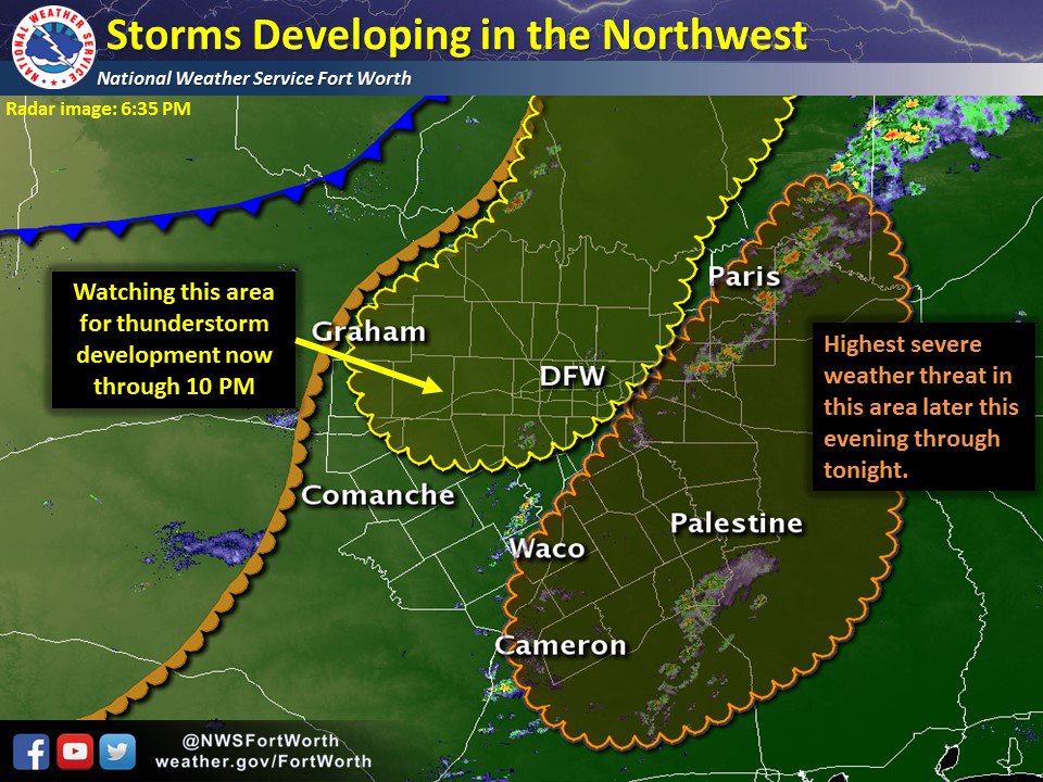
Recent runs of the HRRR have been trending towards a more robust band of storms moving across DFW late tonight.
-
1 hour ago, aggiegeog said:
Today will be very windy across NM and W TX with winds gusting to near 60 mph and even higher in the mountains. This system looks to come through dry out there outside of high elevation snow showers above the resorts. The front will move into N and E TX tonight bringing showers followed by falling temps through the day tomorrow. Temps could fall into the low 50s by tomorrow evening. The weekend looks cool with highs in the upper 50s to near 60. Saturday morning will likely be in the 37-45 range (the less wind the colder it will get). Sunday morning will likely feature widespread frost with some spots below freezing.
FWD has the point forecast low at 33 for the areas around me. So it wouldn't take much more for some in the northern areas to see the 1st freeze of the season. Also, maybe a rumble of thunder tonight!?
-
Record high at DFW today - 87
-
And it looks pretty dry for the next 7 to 10 days, things are getting bad in NE Texas.
-
On 11/8/2016 at 11:30 AM, DFWWeather said:
DFW Airport sets another unprecedented record today. It still has not fallen below 50°F officially. Last year set the latest record of doing so on November 8, 2015. Unless we can manage to do so in the next couple of days (and it might be close), this is really going to be some record of being the latest ever to fall below 50°F. On top of which, when is it going to get colder? I thought for sure the drop of the SOI at the end of October would have forced the pattern change. GFS is on board for later next week for a real cold front, but the ECMWF has been waffling back and forth with the latest runs deflecting all the cold air to the east. My hopes for any winter a really going down with each passing day.
All the signs were there back in October for a flip to colder by mid-Nov but that isn't going to happen. It is looking more and more like this will be torch of a winter! I just hope we can luck out and get a couple of strong cold shots to break up the lameness of continued warmth. Only problem, currently there is no cold air on our side of the globe and our source region is just non stop torching.
-
Just under 4" IMBY this morning to add to the 1/2 inch from the weekend. Not too bad but some areas had over 5" by last night. This ended up being a pretty nice system for DFW.
-
At least it looks wetter for DFW over the next couple of weeks. However, raging Pacific jet and +PNA looks to keep any cold air off the menu.
-
Ugly... just Ugly...

-
6 hours ago, aggiegeog said:
Models are starting to see the flip. My 11/8 freeze date may be a tad early but likely not by much. As long as the cold does not set up over the Lakes we look to be in good shape for the winter. The bigtime snow buildup over NW Canada seems to bode well for Arctic highs sliding down the lee of the Rockies this winter.
Yea, hopefully the cooling Pacific ENSO regions will keep the PNA from being jacked up all winter. Last year the DJF PNA was +0.78, +2.02, +1.48 and that helped keep what little cold air there was well off to our NE.
-
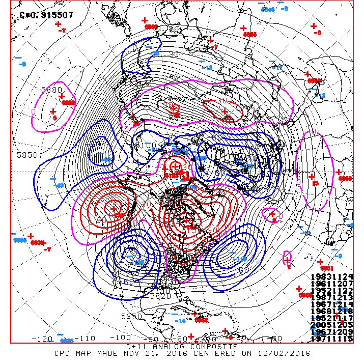
Another warm October analog that seems to jive some what with the current ENSO evolution is 2000. The winter of '00 - '01 ended up being pretty cold overall. The below are hotlinks but I'll try to update them to saved images later when I get off the plane:
October 2000

Dec - Feb '00 - '01

So a warm October is not a lock for a warm winter in DFW. It will be interesting see how things evolve but it is hard to bet against a torch of a winter
, despite what some of the better analogs show.
The latest Euro Weeklies have snow showing up in DFW in the mean and the control run! It looks to flip things to cold after the first week of November, that seems a little quick based on what I'm seeing. Still think that we are warm into the 2nd week before flipping but would love to be wrong on that.
Texas/New Mexico/Louisiana/Mexico Obs And Discussion Thread Part 8
in Central/Western States
Posted
Both the Euro EPS and GEFS are building some nice anomalies in our source region by the end of the runs. Could be a legit artic dump around mid December?