

bubba hotep
-
Posts
2,665 -
Joined
-
Last visited
Content Type
Profiles
Blogs
Forums
American Weather
Media Demo
Store
Gallery
Posts posted by bubba hotep
-
-
1 hour ago, Chinook said:
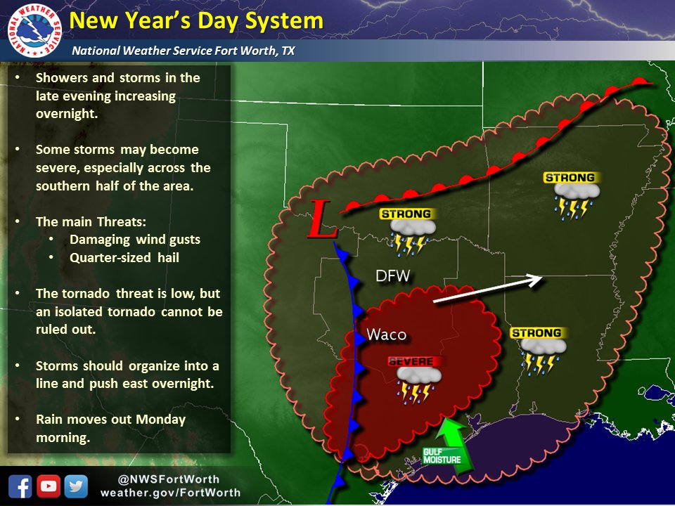
It looks like the CAPE will be higher at nighttime than in the daytime. There might be a half-dozen storm reports at 4:00AM. The convection-allowing models show showers and thunderstorms traveling or developing some 300mi+ eastward across Texas in the time frame of 06z to 12z. There could be a number of severe storms. It would be very climatologically unusual for a severe storm at 3:00AM on January 2nd.
Plenty of anomalously high PWAT air pooled up across the northern Gulf right now.
-
There is always this to track....
-
21 hours ago, bubba hotep said:
Yep, la nina plus big -EPO seems to favor the full latitude trough.
After flipping through some analogs, the current +PDO seems to be the wrench in things. Dec '83 was during a +PDO but most others were during -PDO periods - '49, '51, '62, '64, '73, '75, '13. Over the last few days there was a pretty big warm signal in the ensemble spread with the operational runs on the colder edge of the spread, so the potential was always there for the ops to trend warmer.
-
What a train wreck on the 00z GFS

-
35 minutes ago, raindancewx said:
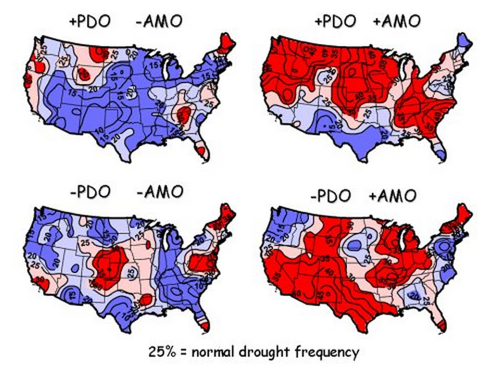
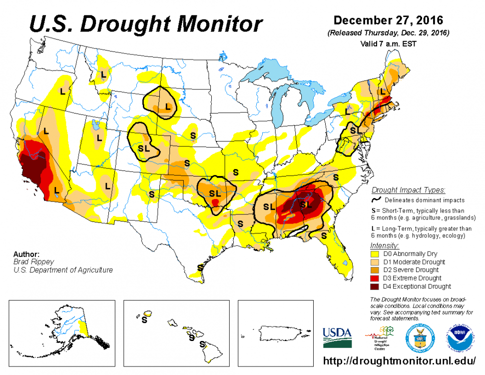
Looks like the drought in much of California is shrinking. Pretty good match of the classic 'AMO/PDO' both positive drought expectation map except in the NW, due to the La Nina flavor. East Coast, California, Colorado drought definitely matches. May end up being a really nasty thunderstorm season in Spring if it stays warm/dry in the SE with big storms coming into the NW/SW
I was looking at that the other day and with models showing ENSO warming it could be a wet spring.
-
12z Para GFS is Euroish with the 500mb evolution and resulting surface maps.

-
15 minutes ago, DFWWeather said:
Strongly agree...and in this case the colder drier solution looks correct imho. Given the amount of Arctic air that will be flowing down from the north, flow coming almost due north from the Arctic circle, the deeper, colder solution the ECMWF has looks correct. This is a McFarland setup. Folks, this is not a favorable upper air pattern for big DFW winter storm. The op GFS looks like an outlier to me and doesn't agree with the majority of its ensemble members. If anything, further south would be a target for frozen precipitation. I would not be surprised for freezing temps getting into LRGV with this setup.
The EPO going postive allowing for mid month warmup looks in error as the long wave global synoptic pattern says that should stay negative. AO, NAO, WPO, PNA, EPO (arguably) remaining negative points to widespread CONUS cold (save for Florida). Climate Prediction Center is in agreement as well with cold lasting well into week 2 of January. Joe Bastardi explains this today in his morning video. With Greenland blocking this cold is going to be in no hurry to leave with more building up behind it.
Yep, la nina plus big -EPO seems to favor the full latitude trough.
-
24 minutes ago, vwgrrc said:
The last couple runs seem to be warmer for dfw metro, hope that's not a trend!
That is one of the things with this setup, the colder it gets the more suppressed it looks.
-
The 00z Euro package was pretty encouraging for us in DFW area. The op had some changes that I liked at H5 and it appears to be the dry outlier with both the EPS mean and control being wetter. About 30 of the EPS members showed some variation of winter weather in DFW.
Also, the Para GFS has been trending our way with 06z being the farthest north yet:

I'm liking the trends but still not sold.
-
Back in the game? Although, that kind of banding would rub me the wrong way

-
54 minutes ago, Quixotic1 said:
18z went north.
It really held back that 2nd piece of energy. It feels like the 12z Euro and 18z GFS are at the two ends of the 500mb spectrum of possibilities for this event. Not based on anything scientific and just a hunch based off watching models the last couple of days.
-
12 minutes ago, DFWWeather said:
If 12z ECMWF pans out for next week...we would be talking severe cold into Texas with freezing temps into the LRGV. With -15°C air sitting over DFW, it would produce surface temps in the single digits for the first time in over 20 years. This still may be obtainable with the GFS solution if we get snow and ice on the ground. This cold with Greenland block may hang around for a while with more into week 2 of January.
There is pretty good agreement b/w the 12z Euro EPS and GEFS on a mid month warm up. However, it looks like it could just be a temporary reload of the pattern before another big -EPO dump. Hopefully, this pattern will hold and the la nina background state will start to fade allowing for some more robust MJO action. Maybe better storm chances in February and March?
-
1 hour ago, Quixotic1 said:
Get the cold. Worry about precip later.
Yep, next week is a long ways off.
-
15 minutes ago, vwgrrc said:
busted? Please do tell
Sent from my iPhone using TapatalkBitter cold and no snow for DFW, maybe something for far East Texas along I20. Orientation of the trough is different than 00z and that looks to keep much of Texas dry and cold. Still lots of time and the setup keeps changing each run in the longer run. Only steady feature is the -EPO and cold. Feb '11 was a Nina snow event driven by an EPO dump, so it can happen.
-
-
This is starting to peak my interest but still lots of unknowns, esp since mesoscale features play a big role in these setups.

-
Models still showing an interesting pattern for next week. I just can't get too excited with what is being depicted but at least the cold looks locked in. Just need one of those disturbances to be tracked and timed right.
-
Another variation of a system that will most likely never come to fruition...

-
Both the Euro EPS and GEFS show this being a longer cold outbreak than the last one, lasting 5 days to a week before a real warm up. They also show our source region staying below normal in the longer range and that might be an indication that another dump is coming after any warm up.
-
2 hours ago, aggiegeog said:
Next week she is looking good for winter lovers. Arctic air with a fairly zonal flow allowing for moisture to ride over the surface cold. Sadly it looks more icy than snowy at this point.
The 00z Euro package was one of the snowiest yet this winter for the northern half of Texas. However, as you noted, that is probably mostly freezing rain given the setup.
-
Still there at 18z

-
12z GFS with a bit of frozen for DFW next week:

-
I'll never forget this, wasn't out chasing, but ended up way too close for comfort.

-
Models seem to be coming into agreement on a bit more sustained cold blast b/w Jan 6 - 10th. Obviously, details still need to be worked out but a -EPO driven cold shot looks to be in the cards. The models have been pretty good at sniffing out these -EPO patterns in the longer range.
Texas/New Mexico/Louisiana/Mexico Obs And Discussion Thread Part 8
in Central/Western States
Posted
Day 2 northward bump to include portions of the DFW area: