

bubba hotep
-
Posts
2,665 -
Joined
-
Last visited
Content Type
Profiles
Blogs
Forums
American Weather
Media Demo
Store
Gallery
Posts posted by bubba hotep
-
-
Things continue to look good for a soaking!

-
11 hours ago, Quixotic1 said:
Phases 1,2 and 3. Not too shabby!
Phase 2 during Nina
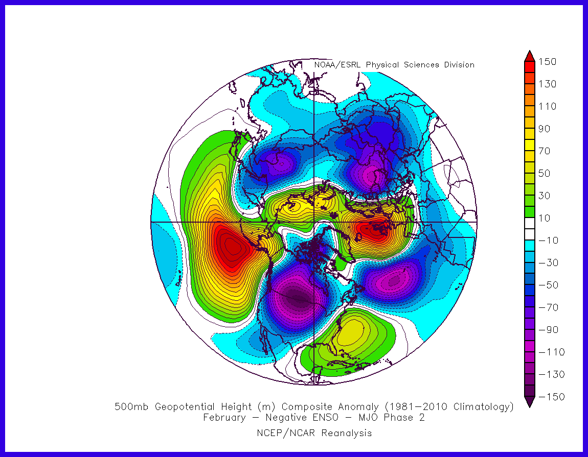
looks suspiciously "McFarlandish"
-
3 hours ago, raindancewx said:
PDO came in at 1.17 for December (JISAO) fell big time from November (1.88)
Big drop but still pretty high for December, a quick glance looks like a Top 10 reading since 1950. Does it stay positive and do we get back to +ENSO? That was a good rain combo for Texas in the recent past.
-
Afternoon AFD from FWD indicates 2-5" of rain from this system with sone areas possibly requiring a flash flood watch. That should help get a jump start on topping off area lakes before the summer hits.
-
43 minutes ago, Quixotic1 said:
I say that every winter/spring when it's boring and nothing to track. I'm still optimistic about later in the winter. Maybe end of January - Early March. Right now, there's little blocking to send cold air our way. Maybe some storms to track this weekend but it seems pretty "meh".
Strat warming about to commence. Never know where the dump will be though.
Good thing for this current system or it would be a two week snooze fest. Hopefully, the Pacific jet will relax and another -EPO will pop. Also, models are trying to get the MJO going, it would be nice if the next cold spell had a connection to some tropical forcing.
-
It looks like the 00z Euro and Para-GFS are farther east with the axis of heavy rain vs the GFS. Looks pretty wet for I35 and areas east.
-
The January thaw is coming... ugh

-
2 minutes ago, jhamps10 said:
Comparison time... Nam Friday morning.. 41 degrees... Gfs??? 64...
Comparison - NAM mostly crap vs GFS usually crap

-
3 hours ago, raindancewx said:
The Atlantic (AMO) was still warm in December, but cooled a bit from November relative to the long-term averages. December was pretty cooler than 1937 and 1952 and a couple years in the late 1800s.
+PDO and cooling AMO... Wet spring on the way?
-
4 hours ago, Quixotic1 said:
it was fairly common back in the 80s and 90s. One memorable one was in 96-97 where it was in the teens in Wichita Falls and balmy 50s in DFW.
I think it's the SE ridge. If it's strong enough and elongated enough, it will hold off arctic intrusions.
That said, this one, according to the AFD this is related to a large upper level low that's going to traverse southern Canada and pull most of the arctic air east with it.
I think you are right. The timing of the lead northern stream s/w, PVA and H5 cutoff were nearly perfect on the big ice storm runs. Those runs also had the SE ridge with a different orientation. The H5 cutoff has trended slower and the SE ridge a bit stronger with a different orientation. The models have been struggling with the SE ridge in the longer range going all the way back to hurricane season.
-
7 to 8" of rain for areas east of I35 on the GFS!


-
18z GFS is 4-6" or rain area wide. This feels more like a storm back from '15 when it seemed like we
 were always having multi rain events.
-
2 hours ago, DFWWeather said:
The 0z ECMWF has backed way off on the cold air resulting in nothing more than a cold rain for this event for nearly all of North Texas. It even loses the connection to deep Arctic air. Not impressed with this run at all.
6z GFS is also backing off on the cold air with all frozen precipitation west of the Metroplex during the entire event.
The OP Euro is on the cold side of guidance in the 00z Euro package and has been the last few days.
-
Factor in cold air bleeding in farther than modeled and this is borderline disastrous

-
2 minutes ago, jhamps10 said:
First look at Gfs, it's going to be very very icy for a good chunk of Texas, SLAMS Arkansas though
Looks to be trending towards the Euro with a big cutoff low.
-
The 12z Para-GFS has got it as well.

The 12z Euro EPS trended towards the operational, the 00z wasn't as supportive of a big system. About 1/5 of the EPS members make up a dry cluster but the rest have some version of the storm.

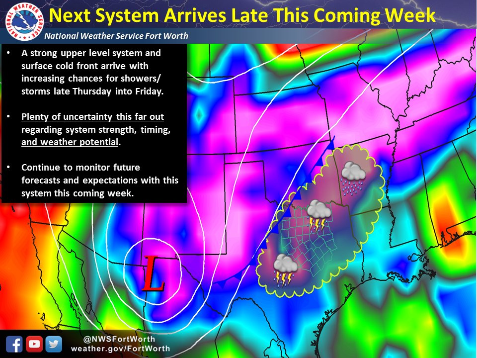
Latest from FWD
-
25 minutes ago, DFWWeather said:
That eastern ridge looks too strong. If we can get that Arctic high underneath the ridge...all bets are off. The ECMWF is known to be too slow in that time range on Arctic air, and doesn't model well the cold air damming process which is clearly evident on the 0z run.
Yes, the SE ridge is a big problem and that is why we don't typically see big cutoff low snow storms during a Nina. Maybe the pattern starts to shift and we have a better look in February but for now the SE ridge probably wins that battle.
-
We need some help but the Euro isn't too far off from a big winter storm. I'll gladly take a solid soaking but will be trying will a winter storm for N. Texas

-
FWD has updated low temps. They keep DFW out of the single digits for now.

-
7 minutes ago, jhamps10 said:
Maybe so, I still think that this one may be more an Oklahoma Icestorm, but it could thread the needle.. Moisture vs the cold air just like most winter setups can be here lol
Here is the 18z GFS. I'll be glad to have another system to track but am really interested in seeing if maybe this is the la nina pattern starting to break down some. We had legit storms earlier in the week, snow today and models look to keep things somewhat active.
 o
o
-
Hard Freeze Warning issued for the northern counties

-
My point forecast low is 13F and we are now down to 15F with clear skies and little wind.
-
HRRR is up to something funny! Hard to tell from that image but it gets DFW to 7F and MBY to 3F...

-
Texas/New Mexico/Louisiana/Mexico Obs And Discussion Thread Part 8
in Central/Western States
Posted
I'm getting crushed over here! I never had allergies in DC and then move here and Mt. Cedar hit me like a ton of bricks. This go round is horrible, the whole family is down with it.