

bubba hotep
-
Posts
2,665 -
Joined
-
Last visited
Content Type
Profiles
Blogs
Forums
American Weather
Media Demo
Store
Gallery
Posts posted by bubba hotep
-
-
6 minutes ago, raindancewx said:
Have you guys seen this? A meter of snow in the Sahara.
The 1978-79 analog seems to be working...in the Sahara.
That is really cool. How is the 1st week of Feb looking out there? I'll be in Santa Fe around the 6th for a few days.
-
The 12z Euro EPS says maybe there is some hope beyond Feb 7 +/- but things look dry and dull until then. Winter is rapidly slipping away from us.
-
Wow, very impressive storm!
-
Storms trying to fire out west of DFW
-
A combo of the hi-res CAMs point towards a decent chance of someone seeing storms east of I35 today. I've got my fingers crossed!
-
9 minutes ago, raindancewx said:
The dryness in the NW to me implies that the battle between the PDO+ (which favors dryness/heat up there) and La Nina (which favors wetness/cold up there) has been pretty even. The entirety of the West seems to be splitting the difference between the PDO+ effects and the La Nina effects. La Nina winters are warm here - and we have been. But they are dry too...and we haven't been dry at all. The PDO+ favors wet...but mild/cool. We've been wet but warm.
Yea, I was looking at some analogs today the +PDO has been the thing that has me tossing many years.
-
13 minutes ago, raindancewx said:
Been pretty wet these last two months. I had the East Coast dry this winter - not sure if it will work out, they seem like they will have a couple decent storms the next few weeks, but it has been decent the last 60 days. My fear for the Spring is the whole pattern shifts north 200-500 miles and we roast down here. Hopefully it won't happen until April/May though.
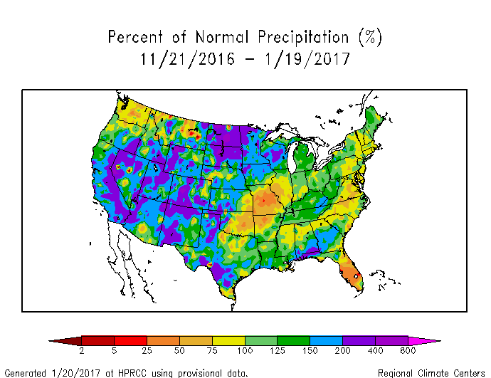
Texas has been lucky and really added those anomalies in the last 10 days or so. Florida has probably been the most "nina" and the SW being the least. Although, there are a few examples of N. Cali doing well and '10-11 was pretty good overall for Cali. Lots of variation with precipitation during ninas.
-
53 minutes ago, aggiegeog said:
This winter has yet to see any particular pattern set up for any period of time.
Overall, it's been pretty la nina like. Two big -EPO dumps but overall dry and warm. The recent big rains are probably the first signs in the sensible wx here locally that the pattern is breaking down. Holding out for one last big cold push. The 12z Euro EPS is really loading up our source region by D15. Just need it to unload.
-
1 minute ago, aggiegeog said:
Eh, Euro has not been good this winter. GFS has been better at long range and Euro weeklies have just about polar opposite of reality at long range. NE Pacific ridging, building cold in NW NA, STJ active, and Canadian blocking are all present or expected over the next few weeks and winter in the past few years has shifted from mid-Nov through mid-Feb to now being more early Dec through early March. To compare to hurricane season we are still in August and the atmosphere is favorable generally, it's not like we have have a roaring jet into Canada.
I was just going to post that the Weeklies have been mostly trash. By D15, already significant difference bw the Weeklies and last nights Euro EPS. There is always the chance that zonal flow dominates and the cold that is building in WCAN in the long range just bleeds out east. However, the pattern so far this winter would suggest otherwise.
-
On 1/18/2017 at 2:08 PM, Quixotic1 said:
Winter is on deathwatch.
Euro weeklies have time of death about Feb 3rd... just ugly.
-
6 hours ago, Quixotic1 said:
Winter is on deathwatch.
18z GFS is scary! Watch this be the one time it is right at 384 hrs


-
6 hours ago, cheese007 said:
At least DFW got a dusting this year!
I've gotten a trace and 0.5" in the books, so better than last winter by a mile! The +PNA brings back memories of last winter. Maybe better moisture return helps get some storms this weekend but the next system after that looks dry. Then NW flow sets in. How far into February do we go before recovering? Climo starts working against us fast!
-
Well... That is unfortunate. I hate the +PNA

-
Where are the Mods? Clean this up!
-
-
2 minutes ago, radarman said:
Might be the first time we made the text of a warning. Full disclosure the storm is fairly attenuated at X band for an ideal view, but I guess there is enough signal for the WFO to at least make out the location pretty well.
I missed it in real time, but see it now going back through the frames.
-
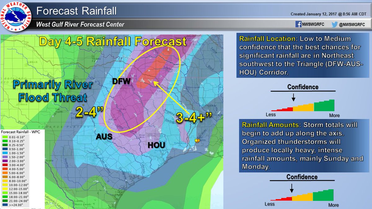
Watching radar, it looks like the flood threat might be realized across portions of the DFW area.
From about an hour ago:
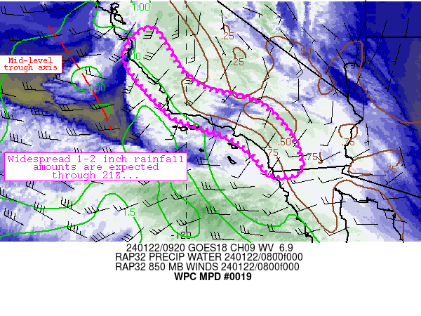
MESOSCALE PRECIPITATION DISCUSSION 0019
NWS WEATHER PREDICTION CENTER COLLEGE PARK MD
712 PM EST SUN JAN 15 2017

AREAS AFFECTED...CENTRAL TX...NORTH TX

CONCERNING...HEAVY RAINFALL...FLASH FLOODING POSSIBLE

VALID 160011Z - 160526Z

SUMMARY...TWO ROUNDS OF CONVECTION IN RAPID SUCCESSION WITHIN AN
INCREASINGLY EFFICIENT HEAVY RAIN ENVIRONMENT MAY CAUSE FLASH
FLOODING IN URBAN OR OTHER PARTICULARLY SENSITIVE AREAS.

DISCUSSION...THE ENVIRONMENT WAS PERHAPS FOREMOST A SEVERE WEATHER
ENVIRONMENT...BUT THE FLASH FLOOD POTENTIAL SHOULD NOT BE
UNDERESTIMATED AS SOUTH TO NORTH TRAINING BANDS OF CONVECTION WILL
BE QUICKLY FOLLOWED BY A QUASI-LINEAR SYSTEM. LATE AFTERNOON HRRR
RUNS HAD BEEN CONSISTENT AT PRODUCING ISOLATED TOTALS BETWEEN 2
AND 3 INCHES STRADDLING THE WARM FRONT / INTERSTATE 35 CORRIDOR
THROUGH 05Z. AT 00Z...THE INITIAL STORMS WERE TRAINING FROM ABOUT
190 DEGREES...FOLLOWING THE MEAN LOWER TO MID LEVEL WINDS...AS
BROAD SCALE LIFT INCREASED AHEAD OF THE EJECTING NEGATIVELY TILTED
MID LEVEL WAVE. THERE WAS A CORRESPONDING SUBTLE BACKING OF LOW
LEVEL FLOW OBSERVED PER RAP SOUNDINGS AND VAD WIND PROFILES FROM
FWS/GRK CONTRIBUTING TO THE TRAINING CELL MOTIONS.

OF PARTICULAR CONCERN...ONE-HOUR RAINFALL ESTIMATES FROM KFWS HAD
INCREASED ABOVE 2 INCHES WEST OF WACO AND HILLSBORO. THIS WAS
FAIRLY CLOSE TO THE RADAR AND AWAY FROM MELTING LAYER
ISSUES...SUCH THAT THERE IS LITTLE REASON TO DOUBT THE ESTIMATES.
PW VALUES WERE INCREASING TOWARD 1.4 INCHES IN THIS REGION AND
OTHER FACTORS SUCH AS INCREASING DEEP LAYER ASCENT AND LOW LEVEL
MOISTURE FLUX WILL FAVOR EFFICIENT RAINFALL PRODUCTION DESPITE
SOME SMALL HAIL.

FLASH FLOOD GUIDANCE VALUES ARE SOMEWHAT HIGH...BUT GIVEN THE
RECENT RADAR QPE TRENDS THE 3-HOUR FFG VALUES MAY BE EXCEEDED
WHEREVER THE S-N BANDS SET UP IN ADVANCE OF THE SQUALL LINE. WITH
THE WARM FRONT ALSO BISECTING THE DALLAS / FORT WORTH
METROPLEX...URBAN RUNOFF ISSUES MAY BECOME A FACTOR AS WELL.

BURKE

ATTN...WFO...EWX...FWD...SHV...

ATTN...RFC...ABRFC...LMRFC...WGRFC...
-
These storms are very energetic, lots of lightning even with these weaker cells.
-
Looks like lack of low level instability could keep this from being a more significant event. Think SPC might upgrade the DFW area later today, if there are any signs of increasing low level instability.
-
-
What kind of skill does the JAMSTEC have?
-
At least the pattern looks to stay active over the next couple of weeks. Not a lot of cold but maybe a system gets timed up just right.
-
Currently 57 in Denton and 77 in Dallas. Front should be moving through MBY any minute now.
-
My allergies are still going strong for a 3rd day, worst attack ever!
Hopefully, the wind shift this afternoon will be the 1st step to relief and then some decent rains.

Texas/New Mexico/Louisiana/Mexico Obs And Discussion Thread Part 8
in Central/Western States
Posted
Thanks! I'm pulling for a big storm. We missed a storm last year but had plenty of snow and it was really cold.