

bubba hotep
-
Posts
2,665 -
Joined
-
Last visited
Content Type
Profiles
Blogs
Forums
American Weather
Media Demo
Store
Gallery
Posts posted by bubba hotep
-
-
13 minutes ago, Quixotic1 said:
Game isn't over yet!
Your strategy of get the cold in place first works out again!
-
30 minutes ago, bubba hotep said:
This band is looking decent, the graupel could be an indication that instability is increasing as the base of the trough swings through. We officially have a dusting at my place.
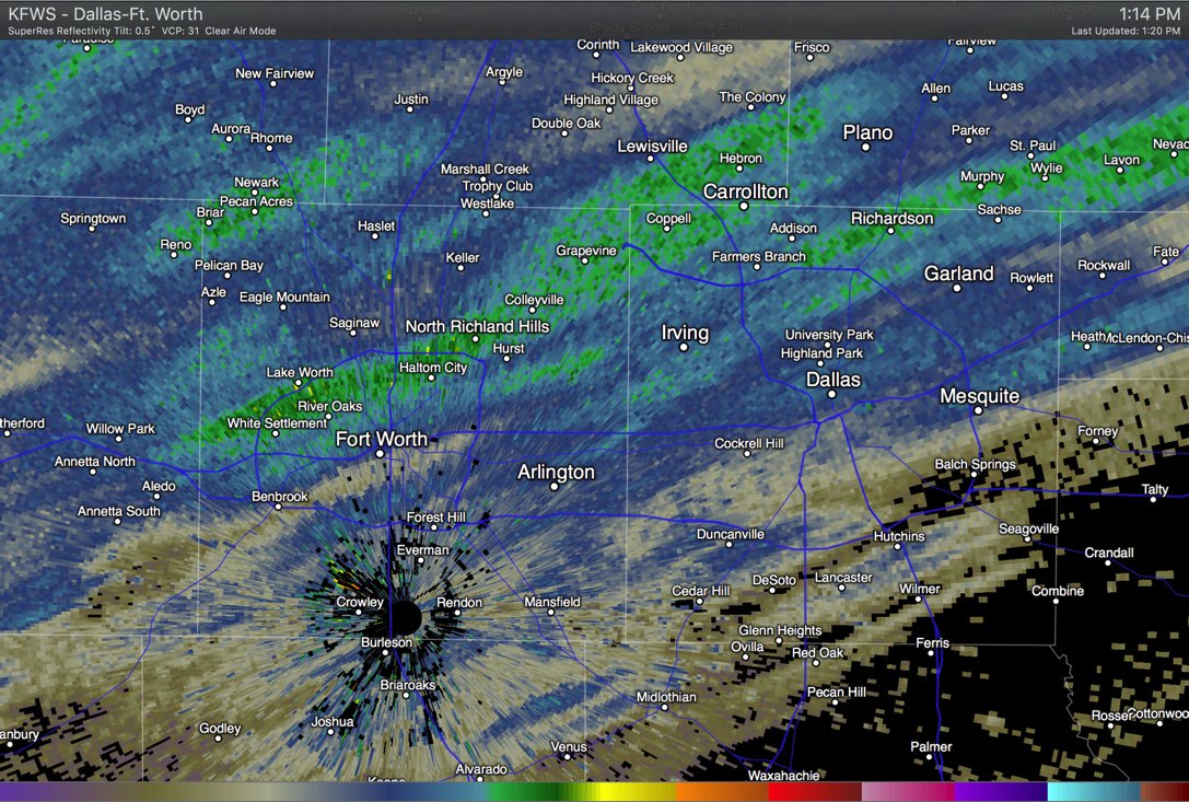
487
FXUS64 KFWD 061955
AFDFWD

Area Forecast Discussion
National Weather Service Fort Worth TX
145 PM CST Fri Jan 6 2017

.MESOSCALE UPDATE...
Clear case of CSI enhanced snowfall occurring over the northern half
of the DFW metroplex with radar showing the classic banded
appearance. The enhanced instability across the DFW area is forecast
to rapidly diminish and shift eastward by 3 pm, but these bands are
going to drop near a quarter inch of accumulating snowfall across
the northern half of the DFW Metroplex and into Hunt and Hopkins
counties and have updated the forecast to reflect that.  So far
impacts from this snow have been minimal in the DFW area, as cold
pavement temperatures are allowing the light fluffy snow to blow to
the sides of the street. With the increasing stability and
decreasing moisture in the snow production layer, the intensity of
this snow will wane to just flurries over the DFW area and end
altogether by mid-late afternoon. TR.92
-
This band is looking decent, the graupel could be an indication that instability is increasing as the base of the trough swings through. We officially have a dusting at my place.
-
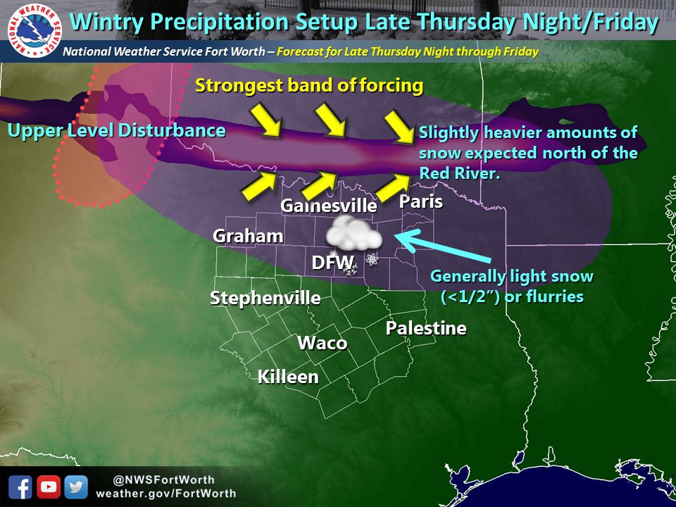
902
FXUS64 KFWD 061745
AFDFWD

Area Forecast Discussion
National Weather Service Fort Worth TX
1145 AM CST Fri Jan 6 2017

.MESOSCALE UPDATE...
This section is a technical discussion of the dynamics for winter
precipitation to point out the features we are watching closely
through the afternoon. The forecast remains on track. See
earlier update for that type of forecast information.

Precipitation is continuing north of I-20 as the upper level
shortwave trough approaches. This is causing frontogenetical lift
to increase near 700 mb which is the critical layer for
precipitation in this event. Parcels lifted near 700 mb are in a
region characterized by weak convective instability (CI) or
conditional symmetric instability (CSI) as depicted by EPV*
charts. The strongest frontogenesis at 700 mb coincides very well
with the location of a band of heavier snow from roughly Lawton,
OK to Hobbs, NM. This band is tracking southeast, along with the
best frontogenesis forcing, and therefore we can use 700 mb
frontogenesis forecasts as a proxy for the location of heavier
snows.

While a radar loop would imply that this band will be tracking
through North Texas around mid afternoon, there a couple of
factors that will cause this precipitation to weaken. The first
being that all models forecast the frontogenetical lift at 700 mb
will begin to weaken by mid to late afternoon. The second more
important reason is that rapid drying is forecast to occur near
and above 700 mb around 2 or 3 pm from west to east over North
Texas. This will obviously limit the moisture for significant
precipitation but it will also result in increasing stability
aloft that will end potential for CI/CSI. We should see the impact
of this dry air with radar echoes clearing out rapidly from west
to east across the CWA between 2 pm and 5 pm.

If we don't start seeing an erosion of these echoes by 3 pm in
our western counties, it will be because the models likely have
miss-diagnosed the amount of dry air. This would result in
slightly higher amounts of snow along and north of I-20, but even
in this case we're talking only a half inch more than currently
forecast.

TR.92
-
Latest HRRR run is trying to get some snow for DFW, esp. the northern burbs:

-
Anyone getting flurries?
-
36 minutes ago, Quixotic1 said:
The bigger positive busts have been due to troughs/short waves slowing down. Don't forget the cold. Higher ratios could help push us over 1". Haha
Ratios will be great. I would rather watch flurries than watch rain while waiting for the warm layer to give up.
-
5 minutes ago, Captmorg70 said:
Yea I agree they may be a bit conservative. Though this setup seems rather tricky. It seems that it really comes down to how much moisture is there when we have better forcing and how quickly it dries out. I kinda miss the storms where we're worried about the cold instead...

Last year was obviously a massive bust but the last few years prior we always seemed to have at least one system that wasn't supposed to do anything turn out to be an 1" or more. I remember one that ended up being thunder snow and nearly 2", forecast the night before was for cold and cloudy.
-
Don't fail me now HRRR!

-
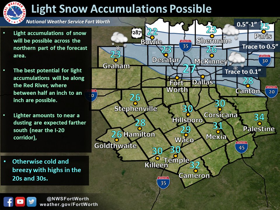
Hard to argue with FWD, but they are probably playing the conservative side. I would move the Trace - 0.5" line down to b/w McKinney and Dallas
-
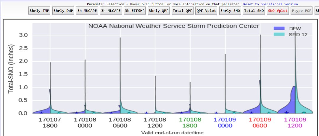
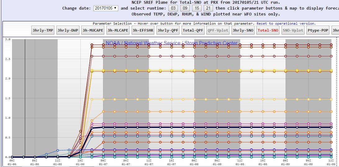
Pretty nice shift in the SREF this evening. I like to use a SREF blend of DFW and PRX for MBY. The trend at DFW today and the 21z PRX plume both look encouraging:
-
Looking at the Euro a bit more, it is slower to dry out the low levels. It looks a lot like the Texas Tech WRF were the flow at H7 is slower to turn allowing for better moisture to be in place as the better dynamics appear.
-
1 hour ago, aggiegeog said:
We are looking at three winter precip areas tomorrow in Texas.
First one is trending north towards the I40 in OK and the Panhandle. It looks to produce around 6" in the Panhandle and a couple inches as you move into eastern OK. This could still trend back south towards the Red River, but I don't see much of this falling in N TX. This event is mainly early tomorrow.
Second area falls tomorrow afternoon into tomorrow evening. It looks to spread flurries to a dusting over N and E TX. Areas along I-30 in the NE TX could see up to a couple inches though as there is more moisture there.
The third area is associated to the Gulf low which may throw some moisture into sub freezing air in inland SE TX in the form of sleet and maybe freezing rain late tomorrow.
One trend in N. Texas this past week or so has been for the models to be too dry in the lower levels. Does that hold for tomorrow?
-
00z Euro was 0.5" area wide with some locals up to 1" depending on ratios.
-
5 minutes ago, raindancewx said:
NWS ABQ call. I'm on board. WPC says my area of town (NE) has a non-zero (10-20%) shot at 4"+, but most likely we get 1-3" city wide or flurries to 2".
I'm going to DC at the end of January and to Santa Fe in February. I hope that I luck out on snow on one of those trips, dial this storm up again in February!
-
It really wouldn't take much of a shift in the thermal gradient to get that banding down to N. Texas
-
18z GFS with that oh so close 1" band

-
1 hour ago, Quixotic1 said:
So, Bubba and I might get dusted. I'll take it.
WPC has us almost in the 10% probability of 1" or greater band. 18z GFS was encouraging and Euro was a slight improvement. I'm thinking "car topper" to 0.5" for us.
-
6 hours ago, raindancewx said:
After the massive spike in November, the PDO has weakened quite a bit in December according to NOAA. Will be good seeing the JISAO value in a few weeks.
https://www.ncdc.noaa.gov/teleconnections/pdo/
Expecting the AMO to drop too, not a whole lot of months like Nov 2016 where it reached >=0.400
https://www.esrl.noaa.gov/psd/data/correlation/amon.us.long.data
I prefer the JISAO data and see it widely used, honestly, I rarely see anyone use the NOAA numbers for PDO. It's not surprising that this La Nina event failed given how warm the overall Pacific was. I don't think there were any analogs with a strongly positive PDO and a medium/strong La Nina. However, the atmospheric response has certainly been more ninaish than I expected given the weak and short lived look. MEI rose from -0.379 to -0.212 and the corresponding '98 numbers were -0.973 and -1.05. Hopefully, this a sign that a wetter Spring might set in.
-
3 hours ago, Quixotic1 said:
Well, if it ain't us, I hope it's somewhere near by or further south. I'm really jonesing for flakes though.
IMBY or bust! We've scored on some of these marginal setups in the recent past. I still think we'll see plenty of model shifting, with two of the main players still several days away. It's just that the shifting will probably be between nothing and maybe an inch, not a lot of room
-
Basically all models showing measurable snow for N. Texas except... The Euro. We've seen this battle before and seen the Euro win. Still, pretty tricky setup and we could see plenty of more shifts over the next couple of days.
-
We got lit up pretty good by the storms this morning, first real thunderstorm action in a long while IMBY. Ended up with a little less than 1/2" to add to the rain from yesterday morning, not a soaker but better than the last few systems.
-
Looks like the 1st watch will snag Ft. Worth but Dallas and areas east of I35 will have to wait until later:
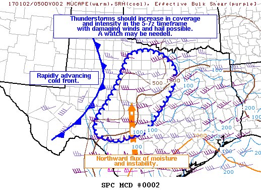
Mesoscale Discussion 0002
   NWS Storm Prediction Center Norman OK
   1011 PM CST Sun Jan 01 2017

   Areas affected...Much of Central Texas

   Concerning...Severe potential...Watch possible

   Valid 020411Z - 020645Z

   Probability of Watch Issuance...60 percent

   SUMMARY...Thunderstorms will increase in coverage and intensity
   later tonight, with damaging winds and hail expected. A watch may be
   needed prior to 06Z.

   DISCUSSION...A rapidly moving cold front continues to move eastward
   across West TX, with several wind gusts in excess of 40-50 kts
   measured and only sporadic lightning. This front will gradually
   interact with an increasingly unstable air mass, still well to the
   east as of 04Z. However, increasing flow in the low levels just
   above the surface will help transport mid to upper 50s dewpoints
   northward out of South TX, with a rapid uptick in storms along the
   front expected as MUCAPE of 500-1000 j/kg develops. This in turn
   should allow for a line of storms along the front, with both wind
   and hail possible.

   ..Jewell/Hart.. 01/02/2017
-
1 hour ago, Quixotic1 said:
January severe weather. Haven't seen measurable Snow in 22 months now.
At this point, I'll just be glad to see some rain.
Texas/New Mexico/Louisiana/Mexico Obs And Discussion Thread Part 8
in Central/Western States
Posted
Forecast high today was 26. Sitting at 21 with snow.