

Chicago Storm
-
Posts
18,671 -
Joined
-
Last visited
Content Type
Profiles
Blogs
Forums
American Weather
Media Demo
Store
Gallery
Everything posted by Chicago Storm
-
Clarity is a thing?
-

January 10th-12th Winter Storm Potential
Chicago Storm replied to Thundersnow12's topic in Lakes/Ohio Valley
Gonna be close, but the best returns/snow may actually miss ORD to the SE. We needed a SE trend, and may have gotten too much of one. -
January 10th-12th Winter Storm Potential
Chicago Storm replied to Thundersnow12's topic in Lakes/Ohio Valley
Kansas City had 3" in 3 hours earlier, per LOT AFD. -
January 10th-12th Winter Storm Potential
Chicago Storm replied to Thundersnow12's topic in Lakes/Ohio Valley
Now that synoptic precip has waned, LES is much more evident across SE. WI and NE. IL. UGN and RAC reporting 3/4M vis right now. At first I thought they were off given only light LES returns, until I checked webcams in the area... -
January 10th-12th Winter Storm Potential
Chicago Storm replied to Thundersnow12's topic in Lakes/Ohio Valley
It's actually performing fairly well down southwest, with widespread 2-5" reports. -
January 10th-12th Winter Storm Potential
Chicago Storm replied to Thundersnow12's topic in Lakes/Ohio Valley
Highest rain report I’ve seen in the region... . -
January 10th-12th Winter Storm Potential
Chicago Storm replied to Thundersnow12's topic in Lakes/Ohio Valley
. -
January 10th-12th Winter Storm Potential
Chicago Storm replied to Thundersnow12's topic in Lakes/Ohio Valley
Lakeshore conditions are fairly significant in NE. Illinois. High waves and surge are causing widespread flooding and erosion. -
January 10th-12th Winter Storm Potential
Chicago Storm replied to Thundersnow12's topic in Lakes/Ohio Valley
There is an arc of deep convection from the Gulf into Canada. Moisture transport is not being hindered for anything currently ongoing. As I mentioned, activity has just been more progressive than expected. Even going back to model guidance just from 24hrs ago, guidance was too slow with eastward progression and over-estimated training. -
January 10th-12th Winter Storm Potential
Chicago Storm replied to Thundersnow12's topic in Lakes/Ohio Valley
That's not whats happening so far. The arc of rain has been more progressive, instead of training. -
January 10th-12th Winter Storm Potential
Chicago Storm replied to Thundersnow12's topic in Lakes/Ohio Valley
You're gonna bust nicely in the snow dept. -
January 10th-12th Winter Storm Potential
Chicago Storm replied to Thundersnow12's topic in Lakes/Ohio Valley
LE ongoing in SE. WI and NE. IL. That should bode well for enhancement of snows later. -
January 10th-12th Winter Storm Potential
Chicago Storm replied to Thundersnow12's topic in Lakes/Ohio Valley
Not even close. -
January 10th-12th Winter Storm Potential
Chicago Storm replied to Thundersnow12's topic in Lakes/Ohio Valley
No real point now given how terrible guidance is, just a guessing game. Still a spread for later today/tonight. Metro could get 1-3" or 4-7". Who knows anymore... -
January 10th-12th Winter Storm Potential
Chicago Storm replied to Thundersnow12's topic in Lakes/Ohio Valley
The summary so far is guidance sucked, and an under-performance just about everywhere in every aspect...almost. Only things that seem to be panning out are the high winds and a corridor in MO/IL/IN that did as expected with rainfall. . -
January 10th-12th Winter Storm Potential
Chicago Storm replied to Thundersnow12's topic in Lakes/Ohio Valley
Yes. -
January 10th-12th Winter Storm Potential
Chicago Storm replied to Thundersnow12's topic in Lakes/Ohio Valley
0z UKMET is a Chicago crusher. . -
January 10th-12th Winter Storm Potential
Chicago Storm replied to Thundersnow12's topic in Lakes/Ohio Valley
0848 PM ICE STORM ELDON 40.92N 92.23W 01/10/2020 WAPELLO IA PUBLIC TREES COVERED IN ICE AND SNAPPING IN SE WAPELLO COUNTY. -
January 10th-12th Winter Storm Potential
Chicago Storm replied to Thundersnow12's topic in Lakes/Ohio Valley
0728 PM FREEZING RAIN BLOOMFIELD 40.75N 92.42W 01/10/2020 M0.20 INCH DAVIS IA PUBLIC 0.2 INCH ICE ACCUMULATION WITH SOME POWER OUTAGES NOTED. -
January 10th-12th Winter Storm Potential
Chicago Storm replied to Thundersnow12's topic in Lakes/Ohio Valley
-
January 10th-12th Winter Storm Potential
Chicago Storm replied to Thundersnow12's topic in Lakes/Ohio Valley
18z Euro bumped east once again. -
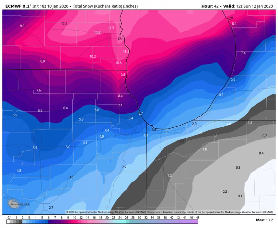
January 10th-12th Winter Storm Potential
Chicago Storm replied to Thundersnow12's topic in Lakes/Ohio Valley
I think it's just the usual case where the RAP will need to play catch-up. Probably will see it do so a bit by the longer range 3z run. -
January 10th-12th Winter Storm Potential
Chicago Storm replied to Thundersnow12's topic in Lakes/Ohio Valley
It's due to the widespread/sig convection. -
January 10th-12th Winter Storm Potential
Chicago Storm replied to Thundersnow12's topic in Lakes/Ohio Valley
TSFZRA in NE. Missouri currently. -
January 10th-12th Winter Storm Potential
Chicago Storm replied to Thundersnow12's topic in Lakes/Ohio Valley
Someone is off their rocker...


