

Blue Ridge
-
Posts
1,533 -
Joined
-
Last visited
Content Type
Profiles
Blogs
Forums
American Weather
Media Demo
Store
Gallery
Posts posted by Blue Ridge
-
-
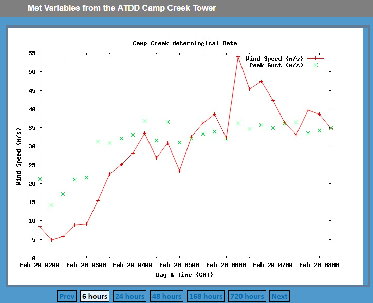
For those playing along at home, 1 m/s = 2.237 mph. Alternatively, use this handy calculator.
Ignoring the high outliers, it looks like Camp Creek is consistently flirting with 40 m/s - nearly 90 mph. (FYI - if that 54 m/s observation is verified, that's ~121 mph.)
@Math/Met Thoughts?
-
 1
1
-
 1
1
-
-
Bantering in a banter thread. Huh. Imagine that.
Re: UT-UK, I think this game said more about UK than UT. Kentucky is a buzzsaw at the moment and firing on all cylinders. Know who else is firing on all cylinders? LSU. I think UT beats UK in TBA but loses to LSU in the Pete. Barring disaster on the road vs. Florida or Bama, that would all but ensure an LSU regular season championship.
Between games at UT, at Ole Miss, and at home vs Auburn, UK may well have two more losses on its schedule. As well as Cal has them playing, tradition dictates an impending late season blunder against a middle-of-the-pack SEC West opponent. ESPN can all but guarantee an Ole Miss win on 3/5 by throwing the game on ESPN or ESPN2 with Karl Ravech and Jimmy Dykes. Ole Miss, with 4 losses but with home games against Kentucky and Tennessee remaining, could very well still nab the 2 seed.
-
2
-
 1
1
-
-
The latest from MRX:
QuoteHydrologic Outlook National Weather Service Morristown TN 308 PM EST Mon Feb 18 2019 /208 PM CST Mon Feb 18 2019/
...Periods of rain and possible flooding from late Tuesday
into Sunday across much of east Tennessee, southwest Virginia,
and far Southwest North Carolina...

Periods of rain, possibly heavy at times, are expected across
southeast Tennessee and southwest North Carolina starting late
Tuesday afternoon.

The heaviest rainfall will likely fall across the Plateau, central
and southern sections of East Tennessee, and southwest North
Carolina where 4 to 6 inches are possible over the next 7 days.
Slightly lower amounts between 2 and 4 inches are expected across
southwest Virginia and northeast Tennessee.

Above normal rainfall has occurred in much of the region over the
past 2 months. Since the ground is already saturated and streams
are high, this upcoming rainfall may cause flooding. Stream
flooding, flooding of roadways, additional ponding of low lying
areas, basement flooding, and mud slides are possible. Some river
flooding is also a concern for mid to late in the week.

There is still some uncertainty on the timing of periods of
heaviest rainfall and exact amounts over the next couple of days.
We will continue to monitor this situation and will pass along
more information as the system approaches.
Quote.LONG TERM...(Tuesday night through Monday)... A very wet but overall mild week is still expected with areas of flooding, although the flood threat will be less widespread than earlier thought. Longwave troughing in the west and ridging off the east coast will keep the TN Valley in an active southwesterly deep layer flow pattern. This combined with an extremely strong upper level jet will lead to enhanced lifting of the copious amounts of moisture being transported into our region. The result will be a series of short wave troughs and surface lows moving northeastward through the TN and OH Valleys along a quasi-stationary front bringing waves of rain until a stronger shortwave next weekend finally moves the western trough eastward and forces the front to clear our region. Even though most of the rain will be light to moderate, the long duration will cause at least some flooding of creeks, rivers, streams, low lying and poor drainage areas, and basements. The above normal precipitation this winter has saturated the soil. Isentropic lift along a warm front will produce a steady area of rain that will lift from S to N across the region Tuesday night. Freezing levels near 12 thousand feet, a strengthening LLJ, and PWATs around 1.2 inches will lead to periods of heavier rainfall rates, but the duration will be short lived as the forcing shifts northward rapidly after 06-08Z. Have categorical pops early decreasing to chance/likely for the second half of the night. A cold wedge is just deep enough for a light mix of sleet and freezing rain in Russell and Washington Counties, VA and extreme northeast TN Tuesday night before 09Z. A light ice accumulation could occur in these areas. WAA Wednesday with the warm front to our north and quasi-stationary cold front to the west will lead to mostly dry and pleasantly warm conditions much of the day. Have pops in the high end chance range until the front to the west and associated fronto-genetic forcing brings rain eastward into the region after 21Z. Increased pops to categorical for late Wednesday into Wednesday night. The front continues to progress faster in latest models, so it now only looks like a 6-8 hour window of decent rainfall rates. Have pops tapering to chance/likely after 06Z Thursday from W to E. The exception is extreme southeast TN and southwest NC where the boundary will stall and cause steady rain to persist through Thursday afternoon. QPF from Wednesday evening through Thursday afternoon should range from 0.50 to 1.50 inches in much of southwest VA, the Plateau, and valley with some higher amounts around 2 inches across far southeast TN and southwest NC. These amounts are significantly lower compared to a couple of days ago and are low confidence due to run to run inconsistency among the guidance. High winds are likely in the peaks and foothills of the Smoky Mountains in far east TN Tuesday night through Wednesday. Southerly 850 mb winds of 50-65 kts across the terrain, strongly negative Omega, and a duct function up to 24 C indicate this could be a classic mountain wave event. Have issued a High Wind Watch for the peaks and foothills of Greene County to Monroe. It is possible that an advisory will be needed farther north. Another wave quickly developing on the active frontal boundary Thursday night will bring showers back to the region. Have fairly high pops returning to all areas Thursday evening through Friday night. The ECMWF and GFS are in decent agreement with this, but suspect there will be breaks in the rain during this time as isentropic ascent is usually forced northward when a low passes to our west. After a brief break Saturday, a strong shortwave is still progged to induce cyclogenesis in the Plains and Midwest which will move a strong, pattern changing cold front across the region. Slight timing differences continue among the guidance, but have likely pops spreading in Saturday night into Sunday afternoon. A strong LLJ and deep moisture ahead of this front, strong fronto-genetic forcing, and unseasonably high PWAT values once again will bring the potential for a period of heavy rainfall on top of saturated soil. Dry and colder weather will finally move in late Sunday through Monday.
-
5 minutes ago, Math/Met said:
Heavy rain still moving through East TN at 240, so those totals would likely go up if extended 6 hours.
Yikes. Nightmare scenario.
I checked flash flood guidance and...it's pretty low.
-
3
-
-
@Carvers Gap 6z GEFS. Bullseye of 8.5" over Fall Creek Falls State Park. Higher totals across SW North Carolina. Does not bode well for spring tourism in the area. DuPont, in particular, may be looking at a significant stretch of time with popular trails closed.

-
2
-
-
Almost looks like a mesovort just south of Maryville.
In other news, 52 dbz over Johnson City...
-
1
-
1
-
-
1 hour ago, Math/Met said:
12z Euro accumulated precip. There's currently water standing in my yard...doesn't look like that will change much in the next 10 days.
Stepped out for lunch after the initial onset of rain this afternoon and the amount of running and ponding water was absolutely staggering. I fear we may soon see levels on the Nolichucky not eclipsed since 2004.
Several area school systems dismissed early in preparation of potential flooding woes, and it appears they were right to do so. Local children have seen nearly as many flood days as they have snow days this winter!
-
1
-
1
-
-
6 minutes ago, Wurbus said:
Next weeks system looking more like 2-4 inches or rain. Exactly what we don't need!


Tired: ski season
Wired: jet ski season
I particularly love the 6z FV3 at 102, driving a 998 low directly over KTRI and directly into the Blue Ridge.
-
1
-
-
45 minutes ago, Carvers Gap said:
Cold fronts in the Philippines and now low(er) elevation snow in Hawaii. Weird winter.
https://www.sfgate.com/weather/article/Hawaii-recorded-what-may-be-the-lowest-elevation-13607099.php
The Pacific is absolutely wild right now. Watch the storm dive due almost due south:
(time-sensitive)
-
1
-
1
-
-
KCHA hit 81 as of 14:25. Congrats to Chatty!
-
4
-
-
Not a bad idea. The Braves should be an exciting team this year. I'll be in Chitown on business multiple occasions this year and plan on catching a game or two at Wrigley.
-
1
-
-
@nrgjeff My Cubs won't play at Wrigley until 4/8, as they begin the season with a road trip through Arlington, Atlanta, and Wrigley North.
I'm beginning to wonder if Harper or Machado will sign by the time Spring Training is here.

-
1
-
-
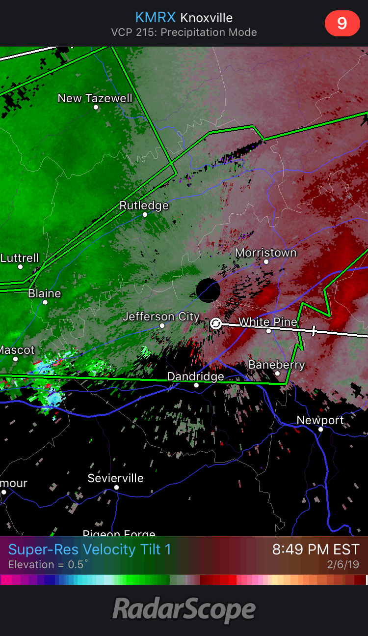
Either this is in an odd spot for radar, or this cell briefly produced.
See subsequent post for reflectivity scan.

-
1
-
1
-
-
...A TORNADO WARNING REMAINS IN EFFECT UNTIL 830 PM CST FOR SOUTHWESTERN DAVIDSON...NORTHWESTERN WILLIAMSON AND SOUTH CENTRAL CHEATHAM COUNTIES... At 812 PM CST, a severe thunderstorm capable of producing a tornado was located over Pegram, or 14 miles south of Ashland City, moving east at 40 mph. HAZARD...Tornado. SOURCE...Radar indicated rotation. IMPACT...Flying debris will be dangerous to those caught without shelter. Mobile homes will be damaged or destroyed. Damage to roofs, windows, and vehicles will occur. Tree damage is likely. This tornadic thunderstorm will remain over mainly rural areas of southwestern Davidson, northwestern Williamson and south central Cheatham Counties. This includes Interstate 40 between mile markers 182 and 197.-
2
-
-
Getting absolutely gobsmacked in G-vegas. Ditches full. Imagine a FFW will be issued before long.
We knew this training band would set up somewhere, but most guidance had it closer to the KY/TN border.
Edit: Just as I posted, not one, not two, but three separate house-rattling claps of thunder. Whew boy.
-
11 hours ago, Holston_River_Rambler said:
Rejoice!
The Flying Spaghetti Monster has brought us a rando model showing snow, snow, and more snow, to bestow upon us with his noodley appendages!!!!

I'm beginning to suspect you may be @paulythegun on Twitter...
(if you don't follow, give him/her a follow.)
-
1
-
-
27 minutes ago, Holston_River_Rambler said:
Here is a pretty snow map. Look at all the colors. They are pretty! Snow is fun.
Happy Times! Whheeeeeeeeeeee!
Hell yeah brother, cheers from the winter asylum
-
1
-
-
9 hours ago, John1122 said:
Probably the toughest aspect of this winter is that we entered January with what seemed to be great players on the field heading into the most favored period of winter for Jan 15th-Feb 15th. Through all of that I managed about 6 cold days and 1/2 inch of snow after the ensembles of every model kept spitting out 3-6+ inches valley wide for several 15 day periods. It's hard to believe that that many members missed everything that often.
These days I have a go big winter or a go home winter imby. I pretty much go over 20 inches or stay under 8 with no in between. For the balance of my life there was a 4 inch snow at minimum every single winter. This looks likely to be the 3rd in a row without one. I did have a 4 inch event last year but it was in late March when winter was over. The year before I barely managed more than 4 inches the entire winter, literally the lowest total here, possibly ever but for sure in the last 70+ years. The two winters before that I was around 30 inches and a lot of ice. The 1990s were this way to a large extent. Except there wasn't a winter in the 1990s that I didn't get at least 4 inches in a single event. Carvers mentioned this Nino reminded him of the 90s Ninos. The entire decade reminds me of them. Super strong Ninos both decades. A few frigid snowy winters and several warm wet ones. Most of the time I feel like I've moved 150 miles south of where I lived in the 1970s and 1980s.
John, it seems like just 10 years ago we were seeing monster NW flow events at least once a winter that would even get the valleys in on the fun as shortwaves rotated around the base of a trough. Seems like I recall a blizzard warning in portions of WNC during one such event. Am I crazy to think those events have suddenly diminished as well?
-
The GFS has continually flirted with severe since Jax mentioned it above - less so than the 12z Euro, mercy.
Fitting, as we are almost to the 11 year anniversary of the Super Tuesday outbreak.
-
Decent snow squall moving through now.
-
1
-
-
1.5 is my total in Greeneville proper. No road issues to speak of, though freezing overnight will undoubtedly change that.
-
4
-
-
Thanks for your input as always, Jeff. I certainly am not aiming to travel down the political wormhole that seems to open any time the phrase “climate change” is spoken, but I do believe this to be a major reason why winters/ENSO/etc. seem to no longer behave in a manner to which we are accustomed.
-
4
-
-
Looks like the GFS has backed off a bit for now. Way too early to tell obviously.
<banter>I'm all too happy to throw in the towel on winter early if that would net an active spring, but I won't hold my breath.</banter>
-
1
-
-
5 minutes ago, BillT said:
what is happening outside, the radar showing where precip is falling, the front lines showing where fronts are the animations showing where stuff is moving.......honestly asking what is the real weather is part of my points,you seriously needed to ask that?
Ah yes, 41 and sunny is positively riveting content for a banter thread.
Discussing short-range, hi-res forecast model trends (and comparing/contrasting to mid- and long-range trends) is part of the process. That is "real weather," and our crew discusses it at as high a level as you'll find.
Winter 'Tis the Season Banter Thread 2018-2019
in Tennessee Valley
Posted
So much for my bold prediction above...lol.