

Blue Ridge
-
Posts
1,533 -
Joined
-
Last visited
Content Type
Profiles
Blogs
Forums
American Weather
Media Demo
Store
Gallery
Posts posted by Blue Ridge
-
-
I also remember in 14’ or 15’ a similar downsloping storm with boarder line temps. The forecast for most of E Tennessee valley was snow to rain to snow. I was only expecting an inch or so. Well the WAA stayed within 20-30 miles of the foothills and the northern plateau created a CAD in the valley north of Knoxville. I never changed to rain and ended up with 6-8 inches. Anyone remember this?
.
I remember that, but now they’re all meshing together in my head. I’m going to have to spend some time this weekend bookmarking and organizing old storm/obs threads for easier reference. Lol.-
 1
1
-
-
We have been following this threat for almost 10 days, and the period (as a period to watch) several days longer than that. We are probably too invested at this point to just give up.. If we end up disappointed, so be it. We've certainly had a lot of practice in that category.....lol
Indeed we have!
This reminds me of a system from a few winter seasons ago, maybe 2014 or 2015? I tried to dig but Tapatalk is garbage for viewing post history. Anyway, East TN was well positioned for a solid 4-8” snow, until 48-72 hrs when the suppression trend reared its ugly head. Around this time, they slowly crept back to the NW w/ the precip shield, until short term modeling took over and brought it home. I want to say it was a solid 3-6” snow for much of the eastern Valley and mountains.
Moral of the story: there is hope, friends!-
3
-
-
5 minutes ago, Carvers Gap said:
The 12z GFS come back slightly to the northwest. We needed to see the southward jog stop. Accums are light over NE TN at 12z, but at 6z there was nothing. So, pretty pleased to see that. How many times have we seen models suites jog south only to come back north? Not trying to give false hope or wish cast, it is just crazy how many times this happens.
I had the same thought as you and @tnweathernut re: the ever-present NW jog after awaking to dismal overnight model runs. Now, undoubtedly I risk setting myself up for immense disappointment, but I would rather be on the northern fringe within 48 hrs than in the bullseye. At the moment, I feel good about MRX's forecast and think it may well play out in similar manner.
-
2
-
-
CMC totals:
The money shot: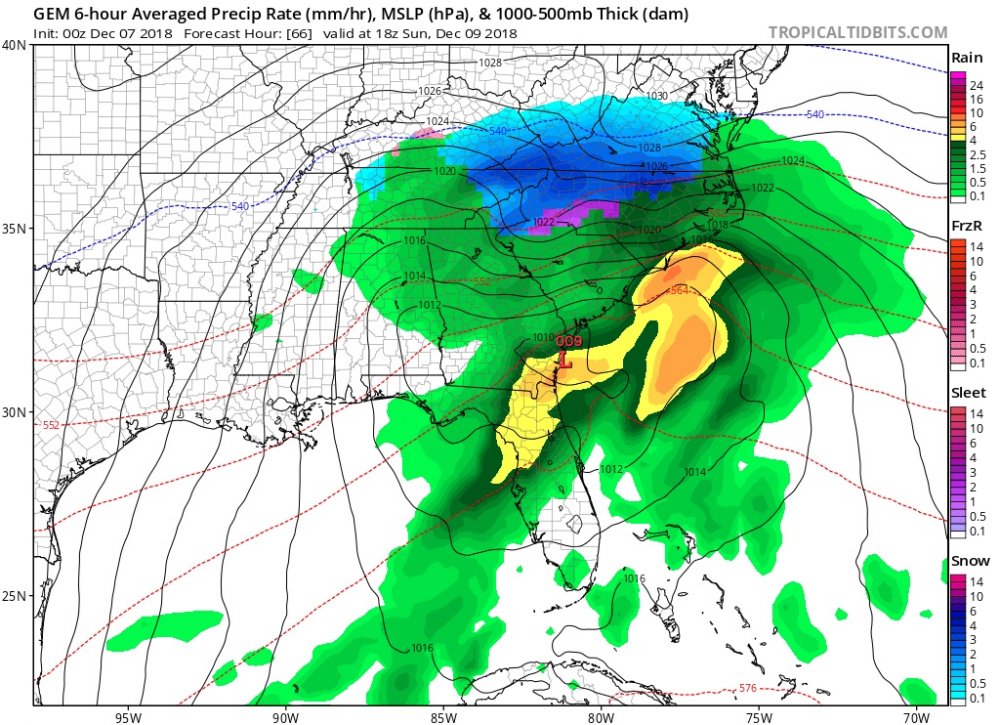
No ZR/IP to speak of.-
1
-
-
Looks like a few flurries are moving through John’s neck of the woods as well. [mention=499]john1122[/mention]

-
I wonder how much of that is ZR?
Consult John’s ZR map above. Looks like a significant amount of that is ZR.
Likewise, TRI totals are cut significantly by IP/ZR. -
So no weather worries for Friday night in pigeon forge my concern would be Saturday night Sunday am and basically no way to watch and try and run back home if it looks like it’s heading my way basically it will be raining and then boom freezing rain or snow all the sudden
Hate to say it, but we just don’t have the answers right now. It’s going to be super close. Next 24 hrs of model runs are key, and then it’s basically nowcast time. Storms such as this in the Valley are so fluid.-
2
-
 1
1
-
-
I sense folks in NE TN going to their favorite wet bulb calculator very soon. Seriously though, if this comes in at night...this could be a mess up here.
RIP 321 corridor.
Seems like if I fart in the wrong direction, I lose power in my neighborhood. Not sure I want .30” of freezing rain and a few inches of cement.
-
 2
2
-
-
Friendship ended w/ GFS.
-
1
-
3
-
-
Just glanced at GSP's disco and updated maps. AVL peeps are on weeniecide watch. Total accumulation was cut by ~60% between the AM and PM forecast packages across WNC.
-
As much as I would hate it for the NC and SC people, I would also love for the warm nose to be more aimed to that side of the Apps. If the 850 low can round the base of the Apps, I'm all for it.
Was just about to mention this. There is a sweet spot for this 850 low, and for East TN to cash in it often involves WNC taking it on the chin WRT the warm nose.-
2
-
-
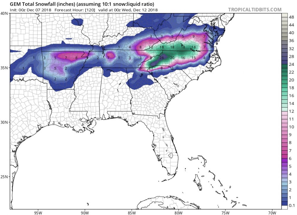
John, I would like to see the Dec 18-19, 2009 storm totals overlaid on that map. I think that tells quite the story.
-
Accompanying MRX PM disco:
.SHORT TERM...(Tonight and Friday)... The short-term forecast is rather benign compared to the long- term forecast. Temperatures have struggled today as high clouds moved in ahead of the next approaching upper level system. This system is currently located to the northwest across the Great Lakes but will race into the Northeast U.S. by late tonight. A cold front associated with this upper trough will slide into the area tonight. Moisture along this boundary will be limited with only a slight chance for a few snow showers late tonight into early Friday morning across portions of southwest Virginia and portions of the northern Cumberland Plateau. No snow accumulations are forecast tonight. Lows overnight will range from the upper 20s to mid 30s. On Friday cyclogenesis will take place along the natural baroclinic zone of the northwestern Gulf Coast as an upper level trough moves across the Baja California. Concurrently, an E-W surface boundary will stretch across the northern Gulf Coast. Isentropic ascent to the north of the boundary will keep conditions cloudy throughout the day but do not expect precipitation will move in until after 00z Saturday. Another cool day is forecast with highs in the low to mid 40s for most locations. .LONG TERM...(Friday night through Thursday)... Isentropic ascent will continue Friday night into Saturday with the atmospheric gradually moistening and light precipitation in the form of light rain overspreading the southern sections of the Forecast area. Clouds will thicken across the northeast section with light northeast winds bringing in cold air from high pressure centered over the the Ohio Valley and eastern states. An upper low moves east along the Gulf Coast with a surface low developing and moving to the southeast coast and then northeastward as cold airmass from strong high pressure over the east keeps cold air in place. The precipitation will increase Saturday and Saturday night from southwest to northeast. The precipitation will be mostly rain Saturday and Saturday evening then transition to snow in the higher elevations and across the northeast where more cold air is trapped. Expect moderate to heavy snow across southwest Virginia and northeast Tennessee late Saturday night and Sunday decreasing late Sunday night as the main system pulls out to the northeast. A Winter Storm Watch has been issued for these areas. The lower elevations in the central and southern sections will have enough warming Saturday through Sunday with only light to little snowfall accumulations. Monday and Monday night the precipitation will gradually decrease with only light accumulations Monday afternoon and night. High pressure settles in Tuesday and Wednesday with another system to move in Thursday with warm enough temperatures for mostly rainfall. -
1 minute ago, uncheelfan said:
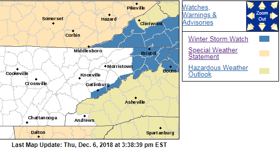
Just got issued a winter storm watch for northeast Tennessee!!!
Sent from my SM-G930U using Tapatalk
Wow, that was not what I expected to happen.
Quote...A STRONG EARLY SEASON SYSTEM WILL BRING THE POTENTIAL FOR A SIGNIFICANT SNOWFALL ACROSS SOUTHWEST VIRGINIA AND NORTHEAST TENNESSEE SATURDAY NIGHT THROUGH MONDAY... Widespread precipitation will move into the area late Saturday as a strong upper level system sweeps into the area. Temperatures will be cold enough across northeast Tennessee and southwest Virginia for precipitation to begin as a mixture of rain/snow or possibly all snow. The best lift and moisture will arrive on Sunday with rather significant accumulations possible ranging from 4 to as high as 12 inches in a few isolated spots. Snow will begin to taper off on Monday. TNZ017-018-041-043>047-074-VAZ001-002-005-006-008-071000- /O.NEW.KMRX.WS.A.0002.181209T0000Z-181210T1700Z/ Sullivan-Johnson-Cocke Smoky Mountains-Southeast Greene- Washington TN-Unicoi-Northwest Carter-Southeast Carter- Sevier Smoky Mountains-Lee-Wise-Scott-Russell-Washington- Including the cities of Kingsport, Bristol, Mountain City, Cosby, Cedar Creek, Johnson City, Erwin, Elizabethton, Roan Mountain, Gatlinburg, Jonesville, Wise, Norton, Gate City, Lebanon, and Abingdon 324 PM EST Thu Dec 6 2018 ...WINTER STORM WATCH IN EFFECT FROM SATURDAY EVENING THROUGH MONDAY MORNING... * WHAT...Heavy snow possible. Total snow accumulations of 4 to 12 inches possible. * WHERE...Portions of East Tennessee and Southwest Virginia. * WHEN...From Saturday evening through Monday morning. * ADDITIONAL DETAILS...Travel could be very difficult to impossible. The hazardous conditions could impact the morning commute. PRECAUTIONARY/PREPAREDNESS ACTIONS... A Winter Storm Watch means there is potential for significant snow, sleet or ice accumulations that may impact travel. Continue to monitor the latest forecasts.
-
2
-
-
I hear Hugh Freeze is still seeking employment.

-
Honestly I'm not quite buying what the FV3 spit out. You would think and approach into NW GA like that would shoot the 850s up the valley, plus the natural warming downsloping plays. If it approached from as sw to ne from central AL into NE GA, then yeah it would funnel the cold down the valley.
I agree that it looks a bit odd. It looks like the energy splits as it’s transferring, with a piece traveling NW of Chattanooga.
I don’t think an 850 low on its trajectory (prior to the split) would result in what the FV3 is showing. -
Looking at 850, the FV3 has it on top of HSV at hour 72. At 75, it appears to begin transferring. The kicker is that 850 winds are howling across NE TN from the SE or SSE from hrs 75-84. At 87, they have turned ESE. As Math/Met mentioned yesterday, we need a more easterly component to the winds to stave off as much downsloping as possible.
Addendum: the FV3 has been quite consistent for NE TN.

-
3 minutes ago, Carvers Gap said:
I think that is the conveyor deal that Jeff/MRX were talking about. Basically, it catches the fetch off the Atlantic. Not totally sure. What do you think? It comes out in such a weird fashion, I never know what to think?
Looks like it to me. With systems that fail to make the turn, we often see the deform band "get stuck" on the west side of the Appalachians, even after snow has stopped over the western Carolinas. The band is usually just light snow, but often sticks around for a few hours after the bulk of the precip has passed. The most notable event I can recall was one of the two Christmas 2010 systems.
-
2
-
1
-
-
FV3 is behaving erratically again. Skipped hour 84. Hour 90: light to moderate snow from basically Lebanon eastward. Hour 96: Shield actually expands west. Snowing in Nashville.
-
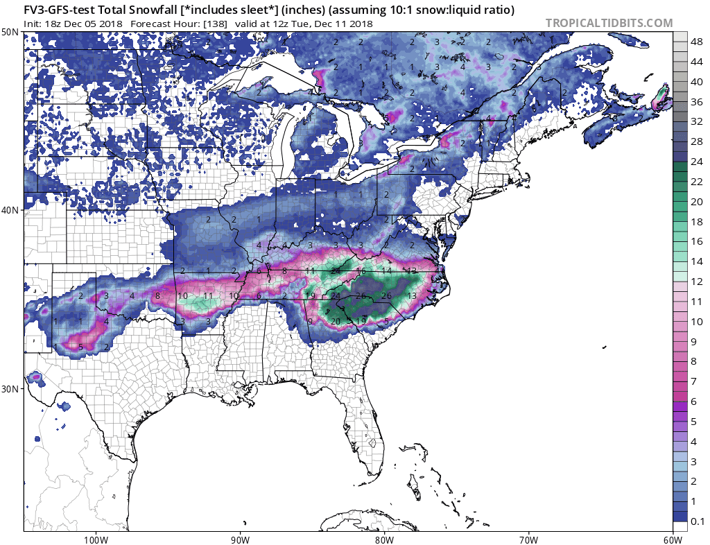
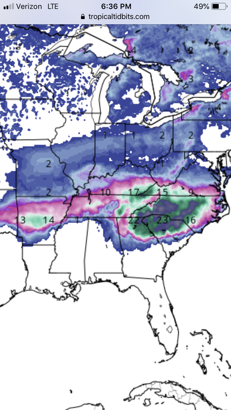
The 0z Canadian is a straight up thumping for NETN/SWVA and the mountains. 2’ in the northeast portion of the state. The QPF turns over to heavy snow quicker than any previous run of the model. QPF totals are just insane for a winter storm. 3.5-4” of QPF for Chatty. 3 to 3.5” for Knoxville and 2.5 to 3” for KTRI. That is indeed a rare sight to see that much moisture modeled from a winter storm.


I’ll conveniently ignore the CMC cold bias and cash out now, please and thank you. -
Well some of us gained back the Canadian. The evolution of the GFS isn’t the final solution. I’m debating staying up to see how long the FV3 can get stuck again at 96. Anyone else?
I’m up for a while longer as well, catching up on process walkthroughs for work. Maybe the FV3 can keep me awake.

-
I agree w blunder storm...looks like downslope. We get it here in Kingsport w northwest flow events often. Sinking air. You can kind of see it where Jeff said the Plateau acts as a snow shadow when precip comes in from the east there, in this case the west side of it.
That was my guess as well but usually that isn’t quite so apparent in guidance at this stage. Cuts totals over those counties from previous runs while increasing the surrounding areas. Interesting solution.
-
1
-
-
150...

Curious why such a hole over Unicoi, Carter, Johnson, and Washington Counties exists. Mixing or downslope?
-
@tnweathernut My friend, I do believe we're due for a good, old-fashioned NAMming.
-
3
-


December 8-10 Storm Discussion
in Tennessee Valley
Posted
Cut in half and that’s a solid 4-6” event across NE TN. That fits well with my current thinking.