

Blue Ridge
-
Posts
1,533 -
Joined
-
Last visited
Content Type
Profiles
Blogs
Forums
American Weather
Media Demo
Store
Gallery
Posts posted by Blue Ridge
-
-
Just now, KSWx said:
Crosbyton cell needs a tor warning.
Check both the Crosbyton cell and the cell ~20 mi east of Roaring Springs on SRV.
-
The National Weather Service in Lubbock Texas has issued a * Severe Thunderstorm Warning for... Northeastern Dickens County in northwestern Texas... Northwestern King County in northwestern Texas... Eastern Motley County in northwestern Texas... Southern Cottle County in northwestern Texas... * Until 315 PM CDT. * At 214 PM CDT, a severe thunderstorm was located 8 miles southwest of Dumont, or 13 miles northeast of Dickens, moving northeast at 35 mph. This storm is exhibiting some low level rotation east northeast of Dickens and near McAdoo. HAZARD...60 mph wind gusts and quarter size hail. SOURCE...Radar indicated. IMPACT...Hail damage to vehicles is expected. Expect wind damage to roofs, siding, and trees. * Locations impacted include... Paducah, Grow, Dumont, Finney, Delwin, Afton and Chalk. -
There it is. >95% watch confirmed.
Buckle up, folks.
-
 3
3
-
-
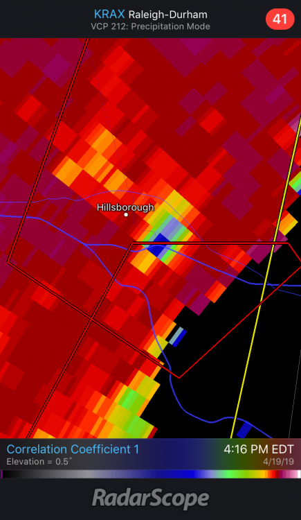
Orange Co. Tornado was an EF2.
QuotePublic Information Statement National Weather Service Raleigh NC 1038 AM EDT Mon Apr 22 2019 ...EF-2 TORNADO IN ORANGE COUNTY NC... Start Location...WHITE CROSS IN SOUTHWEST ORANGE COUNTY NC End Location...HILLSBOROUGH IN CENTRAL ORANGE COUNTY NC Date...APRIL 19 2019 Estimated Time...4:00 PM EDT THROUGH 4:15 PM EDT Maximum EF-Scale Rating...EF-2 Estimated Maximum Wind Speed...115 mph Maximum Path Width...600 yards Path Length...12 miles Beginning Lat/Lon...35.8950/-79.1996 Ending Lat/Lon...36.0418/-79.0906 * Fatalities...0 * Injuries...0 ...Summary... A TORNADO INITIALLY TOUCHED DOWN IN THE WHITE CROSS AREA AND LESLIE DRIVE AREA OF SOUTHWEST ORANGE COUNTY. CONSIDERABLE TREE DAMAGE OCCURRED IN THIS AREA, INCLUDING THE SNAPPING AND SPLITTING OF HEALTHY LARGE-TRUNK TREES. SUBSEQUENT DAMAGE TO VEHICLES AND HOMES OCCURRED AS THE TREES FELL. GIVEN THE MAGNITUDE AND NATURE OF THE DAMAGE, WIND SPEEDS WERE ESTIMATED AT 110 MPH. THE TORNADO THEN TRACKED NORTH-NORTHEAST EVENTUALLY CROSSING DODSONS CROSS ROAD, DAIRLYLAND ROAD, ARTHUR MINNIS ROAD, AND BORLAND ROADS, ALL WHILE PRODUCING SIMILAR TREE DAMAGE. THE TORANDO FINALLY BEGAN TO LIFT AND/OR DISSIPATE NEAR HILLSBOROUGH JUST NORTH OF I-40 NEAR EXIT 261, BUT NOT BEFORE PRODUCING CONSIDERING DAMAGE TO SEVERAL HOMES JUST SOUTH OF EXIT 261. THE ROOF AND SEVERAL EXTERIOR WALLS OF ONE HOME WERE COMPLETELY DESTROYED. DAMAGE AT THIS LOCATION WAS ESTIMATED AT 115 MPH, MAKING THIS TORNADO A LOW-END EF-2 ON THE EF SCALE.
Just missed the more densely populated and developed areas between I-40 exit 261 and I-85 exits 164 & 165.
-
Hampton Roads:
The National Weather Service in Wakefield has issued a * Tornado Warning for... The southwestern City of Norfolk in southeastern Virginia... The northwestern City of Chesapeake in southeastern Virginia... The City of Portsmouth in southeastern Virginia... The southeastern City of Suffolk in southeastern Virginia... The west central City of Virginia Beach in southeastern Virginia... * Until 500 PM EDT. * At 425 PM EDT, a severe thunderstorm capable of producing a tornado was located 7 miles southeast of Downtown Suffolk, moving northeast at 25 mph. HAZARD...Tornado. SOURCE...Radar indicated rotation. IMPACT...Flying debris will be dangerous to those caught without shelter. Mobile homes will be damaged or destroyed. Damage to roofs, windows, and vehicles will occur. Tree damage is likely. * This dangerous storm will be near... Deep Creek and Bowers Hill around 450 PM EDT. Chesapeake, Western Branch and Cradock around 455 PM EDT. Churchland, Downtown Portsmouth, Old Dominion University, Downtown Norfolk, Norfolk State University, Portsmouth and Ghent around 500 PM EDT. -
-
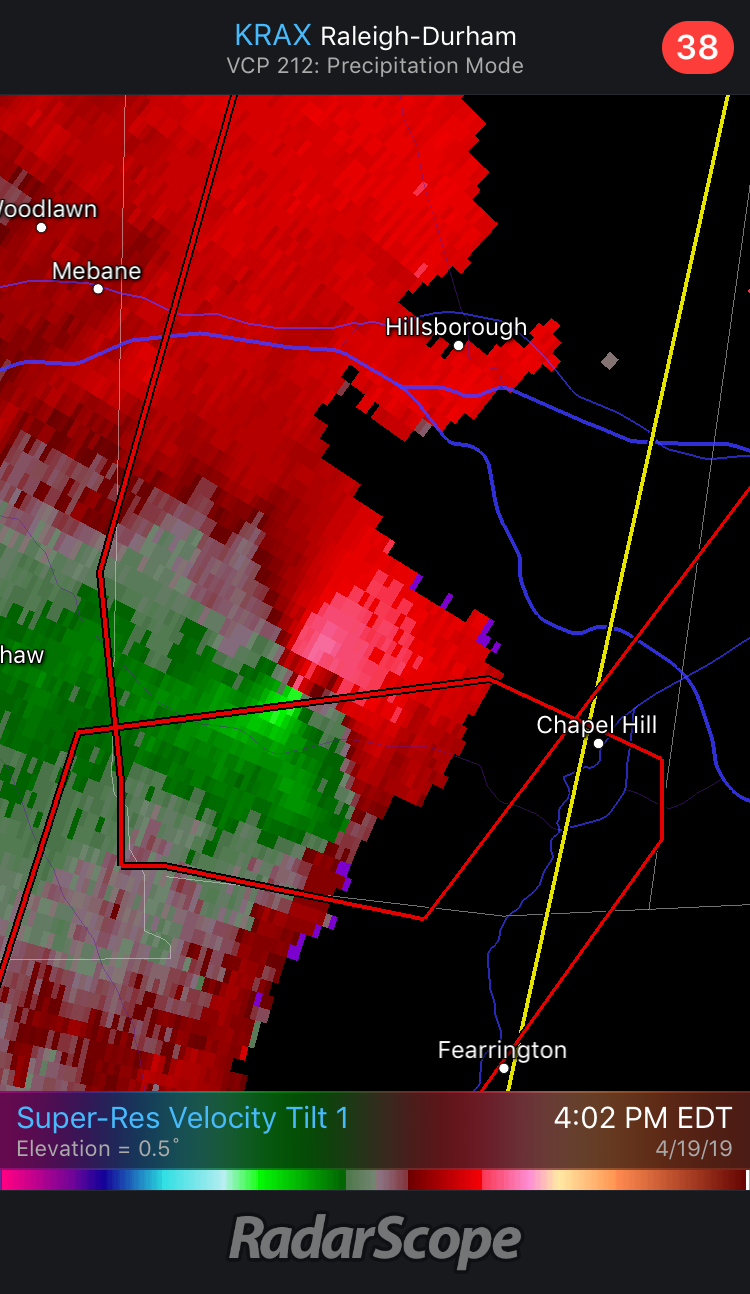
Looks like it may have clipped UNC medical and went right over the huge shopping development at exit 165.

-
Going to be a close call for Hboro.
-
Just now, downeastnc said:
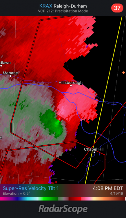
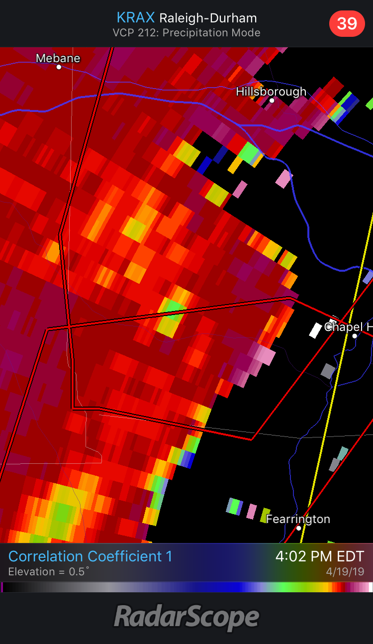
Has a TDS with it.....this is OTG
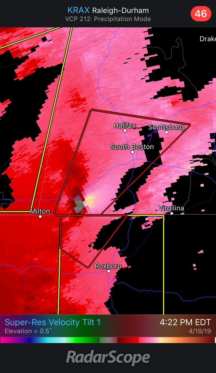
You nailed it. See images above and new warning below...
...A TORNADO WARNING REMAINS IN EFFECT UNTIL 430 PM EDT FOR ORANGE AND NORTHWESTERN DURHAM COUNTIES... At 406 PM EDT, a confirmed tornado was located near Hillsborough, moving northeast at 45 mph. HAZARD...Damaging tornado. SOURCE...Radar confirmed tornado. IMPACT...Flying debris will be dangerous to those caught without shelter. Mobile homes will be damaged or destroyed. Damage to roofs, windows, and vehicles will occur. Tree damage is likely. Locations impacted include... Durham, Chapel Hill, Hillsborough, Carrboro, Rougemont, Efland, Lake Michie, Eno River State Park, Bahama and Schley. -
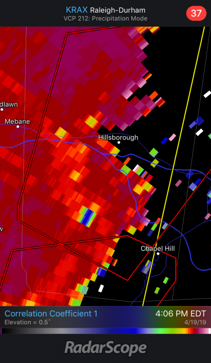
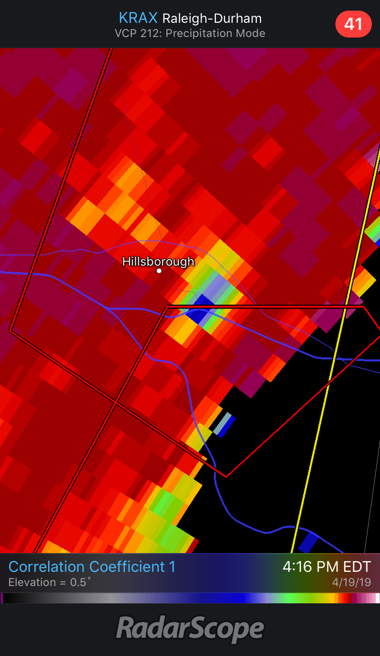
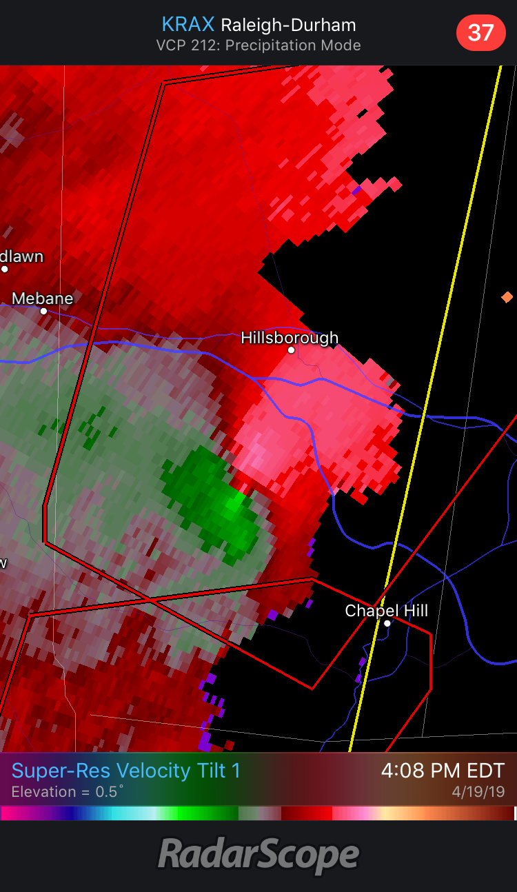
Best looking couplet this afternoon

-
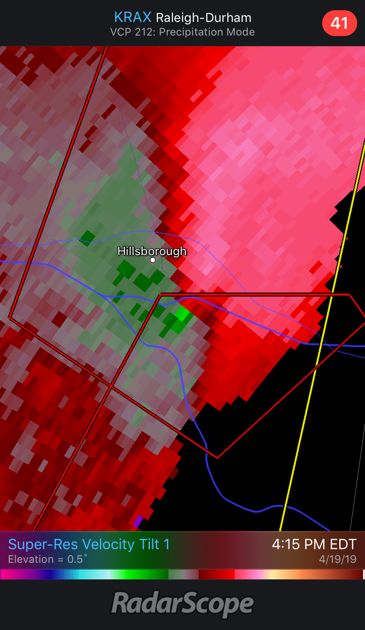
Rotation just west of Chapel Hill has tightened up.
Just as I say that, new warning:
The National Weather Service in Raleigh has issued a * Tornado Warning for... Orange County in central North Carolina... Northwestern Durham County in central North Carolina... * Until 430 PM EDT * At 400 PM EDT, a severe thunderstorm capable of producing a tornado was located near Carrboro, or 9 miles west of Chapel Hill, moving northeast at 45 mph. HAZARD...Tornado. SOURCE...Radar indicated rotation. IMPACT...Flying debris will be dangerous to those caught without shelter. Mobile homes will be damaged or destroyed. Damage to roofs, windows, and vehicles will occur. Tree damage is likely. * Locations impacted include... Durham, Chapel Hill, Hillsborough, Carrboro, Rougemont, Efland, Lake Michie, Eno River State Park, Bahama and Cane Creek Reservoir. -
Another new warning for Fayetteville proper...
The National Weather Service in Raleigh has issued a * Tornado Warning for... East central Moore County in central North Carolina... Southern Harnett County in central North Carolina... Cumberland County in central North Carolina... Hoke County in central North Carolina... * Until 415 PM EDT * At 351 PM EDT, a severe thunderstorm capable of producing a tornado was located over Raeford, moving north at 50 mph. HAZARD...Tornado. SOURCE...Radar indicated rotation. IMPACT...Flying debris will be dangerous to those caught without shelter. Mobile homes will be damaged or destroyed. Damage to roofs, windows, and vehicles will occur. Tree damage is likely. * Locations impacted include... Fayetteville, Raeford, Fort Bragg, Godwin, Antioch, Pope AFB, Hope Mills, Spring Lake, Eastover and Wade. -
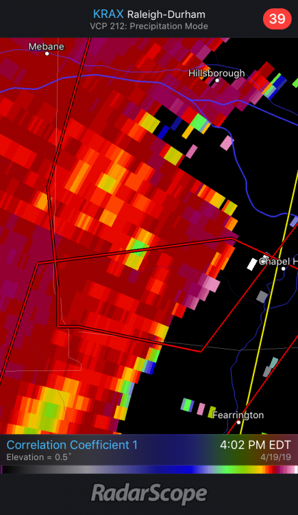
New warning includes Goldston, Pittsboro, Carrboro, Chapel Hill... The National Weather Service in Raleigh has issued a * Tornado Warning for... Southeastern Alamance County in central North Carolina... Southwestern Orange County in central North Carolina... Central Chatham County in central North Carolina... * Until 415 PM EDT * At 350 PM EDT, a severe thunderstorm capable of producing a tornado was located near Goldston, or 9 miles southeast of Siler City, moving northeast at 45 mph. HAZARD...Tornado. SOURCE...Radar indicated rotation.
-
CC scan looks interesting just NE of Ramseur.
-
2
-
-
1 minute ago, SharonA said:
Odd juxtaposition of "CONFIRMED LARGE AND EXTREMELY DANGEROUS TORNADO" with "RADAR CONFIRMED TORNADO" with the east-of-Griffin cell. Usually the confirmed-large-etc source is spotter or EMS.
Meanwhile it's just gusting and damp in S Forsyth County, for now. Not complaining.
Could be wrong, but I believe when the CC bottoms out in a couplet they will go ahead and tag it with some combination of confirmed, large, extremely dangerous, etc.
-
8 mins later...
Severe Weather Statement National Weather Service Peachtree City GA 1201 PM EDT Sun Apr 14 2019 GAC035-151-141630- /O.CON.KFFC.TO.W.0032.000000T0000Z-190414T1630Z/ Henry GA-Butts GA- 1201 PM EDT Sun Apr 14 2019 ...A TORNADO WARNING REMAINS IN EFFECT UNTIL 1230 PM EDT FOR SOUTHEASTERN HENRY AND CENTRAL BUTTS COUNTIES... At 1201 PM EDT, a severe thunderstorm capable of producing a tornado was located over Jenkinsburg, or near Jackson, moving northeast at 55 mph. HAZARD...Tornado. SOURCE...Radar indicated rotation. -
TDS 8 mi east of Griffin, GA.
-
19 minutes ago, SmokeEater said:
TDS

Sent from my SM-G950U using Tapatalk
The loop seen in just to the NW of the TDS is MS Hwy 12. Compare that with the location of campus and...yikes...
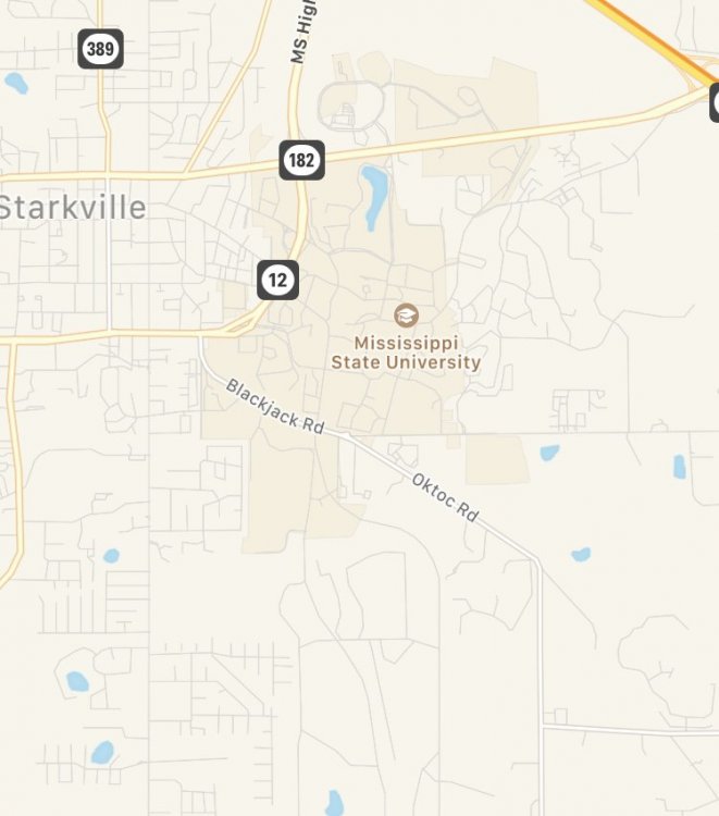
Edit to add: there’s a lot of student/other housing on the east side of campus, IIRC.
-
Looks like the nasty cell that flared up between Newport and Parrottsville verified its SVR. MRX received a report of 1.5" hail in Greene County.
-
1
-
-
21 hours ago, nrgjeff said:
Low and behold Auburn wins the bracket of death. Congratulations Auburn going their first Final Four! While Kansas was weakened, KU can still play very well. Auburn also beat UNC and Kentucky, both at full strength IIRC. Finally Auburn did that with an injury vs UK. One could argue Auburn also beat the officials that game.
Congrats to Auburn on their amazing run. It's a bit reminiscent of USCe's run to the Final Four in 2017: defeat one of the bluest of blue bloods in the Round of 32; defeat a conference foe in the Elite Eight. USCe is a bit more impressive in that they were a 7 seed; Auburn, meanwhile, is a bit more impressive in that they took down KU, UNC, and UK in consecutive games.
UNC was a bit under full strength - Nassir Little was battling the flu and only played 13 min, scoring 4 pts (proof positive he's no Jordan, but he is evidently happy enough with his late first-round draft grade to be a one-and-done). Though he scored 20 and 19 in the first two games, there's no way his ineffectiveness made the difference. Auburn neutered our offense. Carolina loves to run, but they wanted none of that smoke.
I feel terrible about Okeke's injury as well. Auburn had to overcome losing a key cog in their offense AND, as you mentioned, unfavorable calls throughout much of the UK game.
Speaking of unfavorable calls, I feel like the no-call on the blatant offensive foul late in the UVA-Purdue game has been entirely glossed over. Purdue wins in regulation if that is appropriately whistled.
-
2
-
-
18 hours ago, Jed33 said:
Just had one of those storms roll through town here about an hour ago. Several close strikes of lightning and close to 15min of heavy rain mixed with pea sized hail.
I saw the elevated DBZ passing over Morristown and the KMRX radar site and wondered just what the hell was happening under it. I don't believe I heard a single rumble of thunder ~30 miles east.
-
3
-
-
I broke down and mowed after work yesterday. Despite minimal rainfall during the preceding days, things were still quite damp. That was also the thickest March grass I've ever had the displeasure of cutting.
Gonna be a long spring and summer if this keeps up.
-
1
-
 1
1
-
-
Just as I say that, the best looking couplet of the day in AL/MS develops in Cullman Co.
QuoteThe National Weather Service in Huntsville Alabama has issued a * Tornado Warning for... Central Cullman County in north central Alabama... * Until 430 PM CDT. * At 403 PM CDT, a severe thunderstorm capable of producing a tornado was located over Good Hope, or near Cullman, moving northeast at 50 mph. HAZARD...Tornado and quarter size hail. SOURCE...Radar indicated rotation. IMPACT...Flying debris will be dangerous to those caught without shelter. Mobile homes will be damaged or destroyed. Damage to roofs, windows, and vehicles will occur. Tree damage is likely. -
Almost everything north of TN/MS and TN/AL borders fired as junkvection. Storms in MS/AL exhibited rotation, but evidently nothing was strong enough to produce (contrary to my analysis above).


MAY 20, 2019 High Risk
in Central/Western States
Posted
Crosbyton:
The National Weather Service in Lubbock Texas has issued a

* Tornado Warning for...
  Northwestern Dickens County in northwestern Texas...
  Southern Motley County in northwestern Texas...

* Until 245 PM CDT.

* At 221 PM CDT, a severe thunderstorm capable of producing a tornado
  was located 4 miles northeast of Mcadoo, or 12 miles northwest of
  Dickens, moving northeast at 50 mph.

  HAZARD...Tornado and half dollar size hail.

  SOURCE...Radar indicated rotation.

  IMPACT...Flying debris will be dangerous to those caught without
           shelter. Mobile homes will be damaged or destroyed.
           Damage to roofs, windows, and vehicles will occur.  Tree
           damage is likely.

* Locations impacted include...
  Matador, Mcadoo and Roaring Springs.