

Blue Ridge
-
Posts
1,533 -
Joined
-
Last visited
Content Type
Profiles
Blogs
Forums
American Weather
Media Demo
Store
Gallery
Posts posted by Blue Ridge
-
-
1 minute ago, Holston_River_Rambler said:
I think what we're waiting on is a little shortwave to race up from the southwest and give us those last few hours of enhancement.
I really think some eastern valley areas with any trapped moisture and that extra bit of lift could do better than me here on the southern edge of the plateau.
Blue Ridge don't kill me but I wonder if a Greeneville to JC to Abingdon line might do the best?
I think that's a probable outcome. Some of our best surprises have been the result of a strong cold front popping a small S/W. That seems to really enhance the lift and results in the front using the mountains like a squeegee. I feel strangely confident that we outperform MRX's most recent forecast in the Tri-Cities area.
Side note: I'm no longer in the miserable snow bubble of Greeneville and instead in a somewhat more favorable spot just north of Jonesborough. I think I'm slightly southwest of Nut. Looking back at recent history, I feel like I'm in a much better spot for southern stream systems but far enough north to perhaps benefit in setups where Sullivan Co. winds up Ground Zero.
-
 4
4
-
-
Hot off the press:
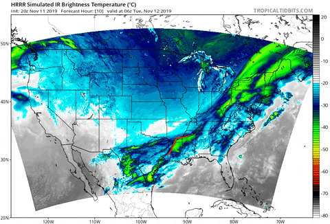
AREA FORECAST DISCUSSION
National Weather Service Morristown TN
307 PM EST Mon Nov 11 2019

.SHORT TERM...(Tonight and Tuesday)...

Radar over Middle TN shows quite a bit of precip falling but surface
obs that are reporting precip are rather sparse as the precip is
falling from midlevel clouds into a dry layer. Rain chances will
gradually rise as the dry layer moistens through the evening. A SW
low level flow ahead of the approaching cold front will maintain
mild temperatures, with most spots in the 50s until around midnight.

The cold front is expected to be at the Plateau around 04Z, and
sweep through the area by 10Z. A sharp drop of temperatures will
follow, and with much of the precip being post-frontal, rain will
transition to snow. The big question, as it has been over the past
few days, continues to be how long temps will be cold enough for
snowfall before drying aloft ends precip. The current forecast will
not make significant changes from the previous one, with the change
over expected to occur mainly between 07Z and 12Z.

During the changeover, forecast soundings show near-freezing
isothermal profiles, which means that only a degree or two difference
aloft can have a big effect on snow amounts. However there are
factors that suggest that model snow amounts are too high, mainly in
the Valley. The primary factor working against snow accumulation is
how warm the ground will be after today`s sunshine and 60s. Another
factor is the presence of a warm nose in model soundings, and the
NAM and GFS have trended toward a deeper above-freezing layer. This
will especially be a factor in the southern Valley where the warm
layer persists longer, and thus may have a mix of sleet in the
rain/snow transition.

The addition of a sleet mix for a few hours south of I-40 will be
the main change from the previous forecast. Forecast snow amounts
will not be changed significantly, with a dusting to a half inch
expected across the central and northern Valley, including
Knoxville and TRi-Cities. The lower elevations of the northern
Plateau and SW VA will have amounts in the half inch to one inch
range, with higher elevations between 1-3 inches. The TN mountains
will also be in the 1-3 inch range.

Rapid drying in the dendritic growth zone will end any potential for
snow accumulations in the 12-15Z time frame. After this time, there
will be a very shallow layer of moisture above steep lapse rates,
which may produce some scattered flurries in northern areas and the
mountains. High temps for the day may occur in the morning as strong
cold advection ensues through the day. Forecast highs in the lower
to mid 30s will be near or below record low max temperatures (see
Climate section below).
-
AREA FORECAST DISCUSSION...UPDATED
National Weather Service Morristown TN
1222 PM EST Mon Nov 11 2019

.UPDATE...
FOR 18Z AVIATION.

&&

.DISCUSSION...

No major changes will be made to the forecast for today, aside
from adjusting hourly temp grids to better align with obs. We will
have one last mild day to enjoy before a frigid air mass builds in
tomorrow morning, with highs today in the lower to mid 60s.

Regarding tonight`s frontal passage and potential snow
accumulations - the 12Z NAM does not appear significantly
different from its previous run. One slight difference appears to
be a slightly deeper warm nose in its sounding at CHA, suggesting
a period of sleet during the transition from rain to snow. Will
await additional data before making any changes to that period.
-
MRX's update:

-
1
-
-
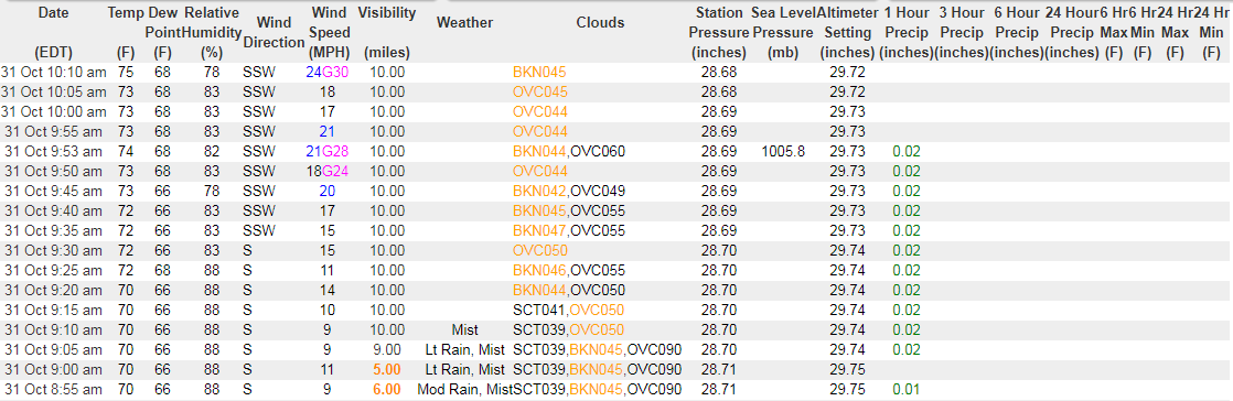
Looks like TYS gusted to 46, Oak Ridge to 44.
-
Tornado Watch #685 is now in effect for Carter, Johnson, Sullivan, Unicoi, and Washington counties in TN as well as all of Southwest VA excluding Lee Co.
-
 1
1
-
-
Zero lightning strikes showing up with this line. Zero.
Widespread wind damage in Jefferson Co.
-
1
-
1
-
-
The National Weather Service in Morristown has issued a

* Tornado Warning for...
  Eastern Claiborne County in east Tennessee...
  Northwestern Hancock County in east Tennessee...
  Lee County in southwestern Virginia...
  West central Scott County in southwestern Virginia...

* Until 1230 PM EDT.

* At 1150 AM EDT, a severe thunderstorm capable of producing a
  tornado was located over Tazewell, or 13 miles southeast of
  Middlesboro, moving northeast at 65 mph.

  HAZARD...Tornado.

  SOURCE...Radar indicated rotation.

  IMPACT...Flying debris will be dangerous to those caught without
           shelter. Mobile homes will be damaged or destroyed.
           Damage to roofs, windows, and vehicles will occur.  Tree
           damage is likely.

* This dangerous storm will be near...
  Jonesville around 1220 PM EDT.
  Pennington Gap around 1225 PM EDT.
The National Weather Service in Morristown has issued a * Tornado Warning for... Eastern Claiborne County in east Tennessee... Northwestern Hancock County in east Tennessee... Lee County in southwestern Virginia... West central Scott County in southwestern Virginia... * Until 1230 PM EDT. * At 1150 AM EDT, a severe thunderstorm capable of producing a tornado was located over Tazewell, or 13 miles southeast of Middlesboro, moving northeast at 65 mph. HAZARD...Tornado. SOURCE...Radar indicated rotation. IMPACT...Flying debris will be dangerous to those caught without shelter. Mobile homes will be damaged or destroyed. Damage to roofs, windows, and vehicles will occur. Tree damage is likely. * This dangerous storm will be near... Jonesville around 1220 PM EDT. Pennington Gap around 1225 PM EDT. -
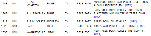
Several reports thus far:
-
New warning for Knoxville:
The National Weather Service in Morristown has issued a
* Severe Thunderstorm Warning for...
Northeastern Knox County in east Tennessee...
Northwestern Jefferson County in east Tennessee...
Southwestern Grainger County in east Tennessee...
* Until noon EDT.
* At 1124 AM EDT, a severe thunderstorm was located over Knoxville,
moving northeast at 60 mph.
HAZARD...60 mph wind gusts.
SOURCE...Radar indicated.
-
1
-
-
The National Weather Service in Morristown has issued a
* Severe Thunderstorm Warning for...
Northwestern Knox County in east Tennessee...
Anderson County in east Tennessee...
Southeastern Campbell County in east Tennessee...
Union County in east Tennessee...
* Until 1145 AM EDT.
* At 1057 AM EDT, a severe thunderstorm was located near Clinton,
moving northeast at 55 mph.
HAZARD...60 mph wind gusts.
SOURCE...Radar indicated.
-
2
-
-
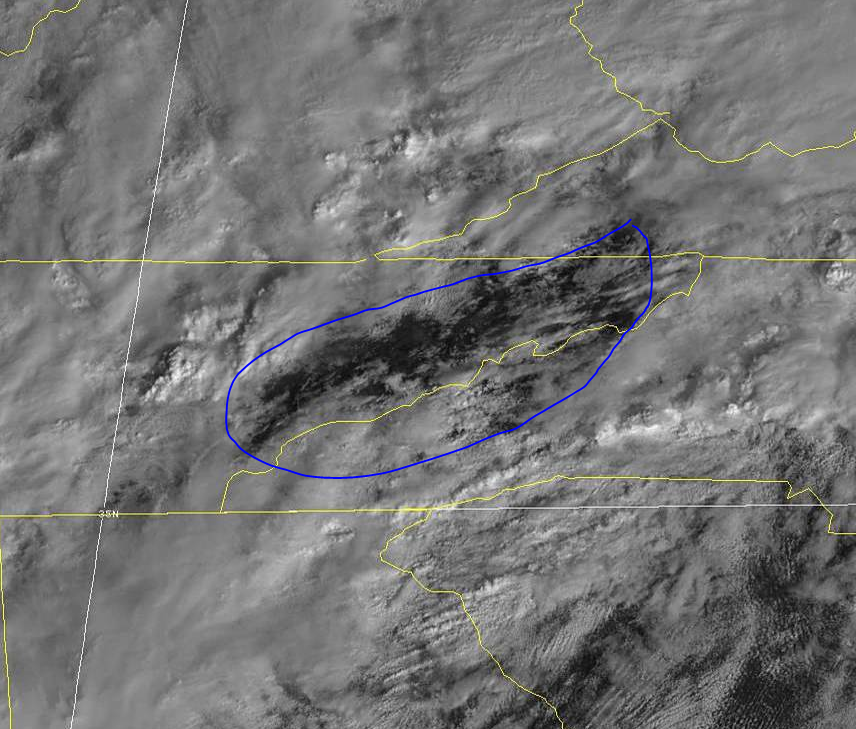
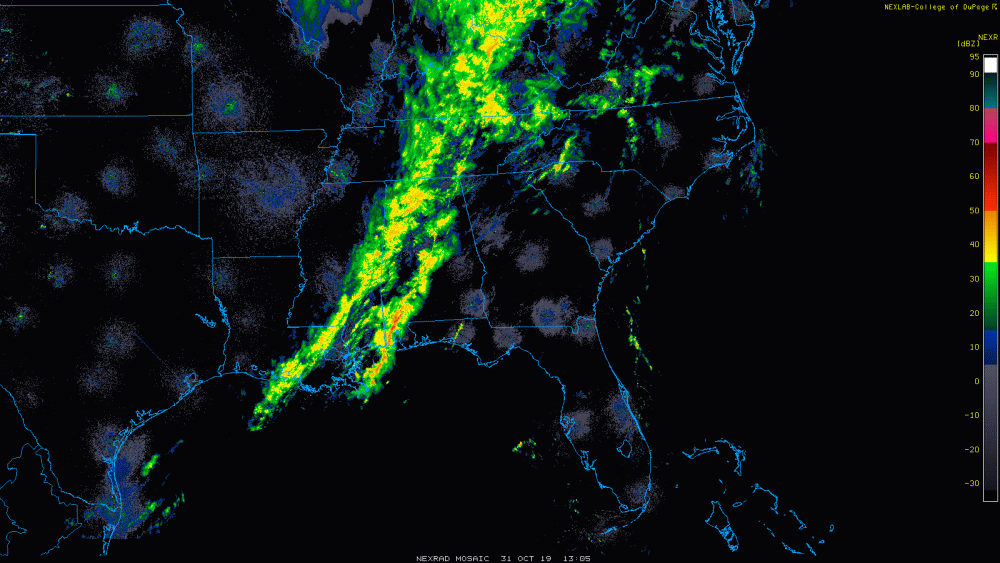
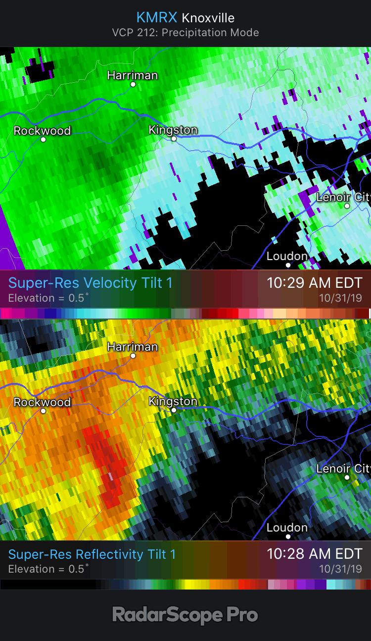
This cell north of Kingston is interesting...

-
2019 is going to continue doing 2019 things, so it stands to reason this winds up a nothingburger. That said, it's fun to track what may well be the last severe threat of the year for the fer east valley.
Some clearing is now visible on GOES East; meanwhile, winds have really cranked up at TYS.
-
2
-
-
SPC expanded the ENH risk southwestward across the far, far northeastern tip of Johnson County. Upper East TN is in 5% TOR.

Any severe weather today will be a matter of threading the needle. MRX sees the LLJ ramping up as a primary catalyst, assuming downsloping does its job and warms the area ahead of the area of showers to the west. The best chance appears to be after this current lobe of moderate rain moves out and the dry area currently north and east of Chattanooga envelops the area. This may allow for warming and an increase in instability.
-
1
-
-
My gosh. The 54 analog rolls on...
-
3
-
-
...THERE IS AN ENHANCED RISK OF SEVERE THUNDERSTORMS FROM PORTIONS
   OF SOUTHERN PENNSYLVANIA SOUTHWARD INTO NORTHERN NORTH CAROLINA...

   ...SUMMARY...
   Severe thunderstorms capable of strong wind gusts are expected
   across much of the eastern U.S. Thursday -- particularly from areas
   along and east of the central and southern Appalachians to the mid
   Atlantic and Carolinas coastal areas.

   ...Synopsis...
   An upper trough crossing the central U.S. at the start of the period
   will evolve into a deepening closed low with time, as the system
   shifts quickly east-northeastward across the Midwest, and then into
   the Northeast overnight.  As this occurs, the broader trough
   surrounding the low will gradually take on a more neutral to
   slightly negative tilt, through the end of the period.

   As this occurs, a cold front -- initially trailing from a low near
   the KY vicinity southward across Alabama to near the mouth of the
   Mississippi River -- will advance steadily eastward during the day.
   The front should cross the Appalachian crest by afternoon, as the
   parent low rapidly deepens and eventually occludes over the Lower
   Great Lakes area, reaching the Atlantic coast after midnight.  This
   front will focus a band of showers and thunderstorms -- and
   attendant risk for severe weather primarily along and east of the
   mountains.

   ...Portions of the PA/NY vicinity southward/southwestward to the
   southern Appalachians...
   A zone of showers and thunderstorms should be ongoing at the start
   of the period from the mid Ohio Valley/Mid South region
   south-southwestward to the western Gulf of Mexico, in the vicinity
   of an advancing surface cold front.  A secondary area of showers --
   perhaps with some embedded lightning -- will be shifting quickly
   northeastward across the Carolinas/Virginia vicinity.  Only minimal
   severe risk -- mainly in the form of gusty winds or a brief tornado
   -- is apparent at this time within either of these areas of
   convection through the first several hours of the period.

   With time, the advance of the cold front across the southern, and
   then the central, Appalachians during the afternoon in conjunction
   with the strengthening upper system will result in gradual
   organization of a band of frontal convection.  Very strong flow
   aloft will aid in the convective organization, with upscale
   evolution toward a semi-continuous band of storms expected.  By late
   afternoon/early evening, storms will likely have become fairly
   well-organized, crossing south-central and southeastern PA, MD, VA,
   and the Carolinas along with attendant risk for strong/damaging wind
   gusts.

   Low-level wind profiles will become supportive of supercells during
   the afternoon across the pre-frontal warm sector.  While suggestive
   of some tornado potential, pre-frontal warm-sector storms are
   largely not anticipated.  Still, a few mainly QLCS-type tornadoes
   will be possible, given the overall dynamic/kinematic set-up --
   particularly from late afternoon through mid evening.

   As storms near the coast overnight, gradual weakening of the
   convection -- and associated diminishing of the severe risk -- is
   expected, though limited wind risk will likely extend to near the
   mid Atlantic/Carolina coasts overnight.

   ...MAXIMUM RISK BY HAZARD...
   Tornado:   5%     - Slight
   Wind:     30%     - Enhanced
   Hail:      5%     - Marginal

-
Breezing through the 12z runs, some of the short-range/hi-res models look pretty interesting across the Appalachian Highlands. I'll leave the analysis to the experts, but the supercell composite and STP in particular caught my eye. Seems like most/all are in agreement on a somewhat potent squall line racing through tomorrow evening; whether discreet cells can form ahead of the line is another story.
Eagerly awaiting the 1730 SPC Day 2 update.
-
1
-
-
3 hours ago, fountainguy97 said:
I moved to Erwin, TN back in June!
Hey, my hometown! Glad to have a set of Erwin eyes on the forum again. As Carvers mentioned above, Erwin is generally in a favorable spot for upslope (northwest flow) snow showers and is full of microclimates. Unicoi Co. as a whole is arguably one of the most interesting weather counties around. (Not biased at all, of course...
 )
)
-
3
-
-
4 minutes ago, Carvers Gap said:
Just crazy how well that 1954 analog has held up...
The 54 analog will be fine assuming the death ridge doesn't return.

-
1
-
 1
1
-
-
Full disclosure: don't consider myself a Vols fan, though I do watch with interest. Certainly not an apologist.
SEC Network's Jordan Rodgers posted on Twitter a great breakdown that more or less proves JG called his own shot on the botched QB sneak. Likely would have been a TD had the play been run as called. He also missed a wide open Jauan Jennings earlier in the game for a sure TD. Had Maurer not been injured, I think the game plays out differently. Bama could say the same about Tua, however. Zebras also got in the way. Absolutely atrocious officiating all night. I think Pruitt/Chaney will do well if given a bit more time. To hear him talk, Pruitt sounds like a dolt, but playcalling and effort have improved greatly throughout the season.
Sit Maurer for the rest of the season. Fire JG into the sun. Start Shrout and throw in the wildcat with Jennings or Jordan. The season is already lost, but I see good things coming. If Maurer looks good, QB debate gets interesting next season between him and the Maryland transfer Kasim Hill.
-
4
-
-
and within 240?
My god. Sound the alarms.
-
1
-
-
Had a nice shower earlier, even a clap of thunder. Nice bonus on a 30% POP day.
Two wildfires made the news this weekend - one in Greene Co. caused by an imbecile burning trash, the other of unknown origin in Carter Co. I fear this is just the beginning should a wetter pattern not soon take hold.
-
1
-
-
Well, that escalated quickly...
-
2
-
-
TW on El Reno storm.


11/12/19 Tennessee Valley Early Winter Event
in Tennessee Valley
Posted
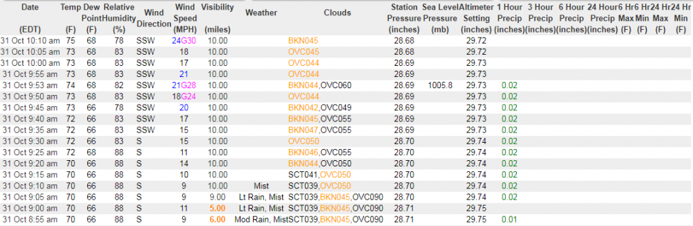
.75" when I measured prior to leaving my house, though my wife reports more has fallen since. Only .25" at my office in Greeneville.
Long live the Greeneville Snow Bubble.