

Blue Ridge
-
Posts
1,533 -
Joined
-
Last visited
Content Type
Profiles
Blogs
Forums
American Weather
Media Demo
Store
Gallery
Posts posted by Blue Ridge
-
-
80/20 ZR/IP just south of Downtown Holly Springs
-
Came back to check on y’all because misery loves company. And because the NAM clowns spat out a fair amount of ZR across East TN. Can’t even visit family at home to escape the ice for this one!
-
 1
1
-
 1
1
-
-
Anxious to see a breakdown of what this run actually shows. The surface presentation is an unholy cluster-**** mess.
-
4 minutes ago, ILMRoss said:
I will say, one thing i don't use the regular NAM for is precipitation depiction. I've always thought it has looked a bit 'off' with its precipitation depiction, dry areas where I'd expect more precip, etc. I think it's fun to look at but I don't hang my hat on it- I lean on the 3km a lot more for that in my internal calculus.
I’m happy to have a red tag validate a feeling I’ve long had but never really expressed. (In my day, hating the NAM was cool - but then the hipsters co-opted the movement.) Is there an explanation for its strange precip outputs?
-
9 minutes ago, kvegas-wx said:
It does appear that this system will be a little moist drinking straight from the gulf. And that CAD signal aint no joke. Might be time for that generator after all.
With Duke electric, a generator is a good idea regardless of forecast! (Am I a true North Carolinian yet?)
-
 1
1
-
 4
4
-
-
2 minutes ago, wncsnow said:
Extrapolated out that would be a crush job for WNC
And likely snow to a lot of ice for Central NC, given surface temps.
-
3
-
-
1 hour ago, Beach Snow said:
18z euro seems the coldest so far of the models
Surface temps in the Triangle aren’t going above freezing for some time with that look.
-
2
-
-
3 hours ago, wncsnow said:
feels like a family reunion here, now we just need Packbacker, Griteater, and Widremann
I finally move to the area only to find Widre has gone missing. Fml
-
2
-
-
3 minutes ago, Silas Lang said:
Maybe it was jinxing us?! Roads are now white here. No more sleet.
Before it starting snowing hard again there was a lot of wind and a few minute burst of heavy sleet. It almost looked like rock salt falling out of the sky. Now it is dumping snow. Down to 31 as well.
Nice little reverse jinx. Good looking out, MRX!
I do find it peculiar to drop the WWA in areas that have already seen snow. Criteria is so low, I would imagine leaving in place would be beneficial to cover potential road hazards at minimum.
-
1
-
-
45°F on the nose with steady light rain. Perfect fall day.
-
Wound up with 5.5" total for the event. Still plenty on the ground today. We'll see if we overshoot forecasted lows tonight.
-
1
-
-
Yo [mention]Stovepipe [/mention], I’m seeing a lot of chatter on r/Knoxville about power outages. What’s up? Surely that happened during gusty winds earlier and isn’t directly related to snowfall?
.-
1
-
-
Someone earlier was asking about potential interaction between mesoscale showers and synoptic band. This loop from Jackson, KY, shows that interaction pretty well, I think.
-
3
-
-
Closing in on 5” here. Lighter band now, but much smaller flakes.
.-
3
-
-
Has anyone been able to get the new dial pol precip type radar on the NWS site to work?
I still have steady light to moderate snow falling. MRX posted no further accumulations the rest of the night a few minutes ago. I'm currently accumulating right now.
Classic MRX now-casting woes.
.-
1
-
-
Just switched to nickel-size flakes. Timed out almost perfectly with CC transition line on radar.
-
2
-
-
Chasing down the 45+ DBZ returns overhead. Unreal.

-
1
-
-
Arctic front has arrived. Worst wind of the whole event just mixed down. I just watched a rocking chair take a ride across my patio.
Edit: check out the waves visible in the velocity product!

-
1
-
-
Y’all noticing the flow on the radar is almost out of the SE into Knoxville?
.
Damn near SSE at it’s current trajectory.-
3
-
-
Watching this cold advance in real-time through the Plateau will be interesting.
-
1
-
-
A note for all trying to predict MRX’s next move:
The overnight AFD and update package usually hits around 0300. As with the afternoon suite, this is sometimes delayed during active weather. Highly unlikely we see any alteration to the warning/advisory package until then. -
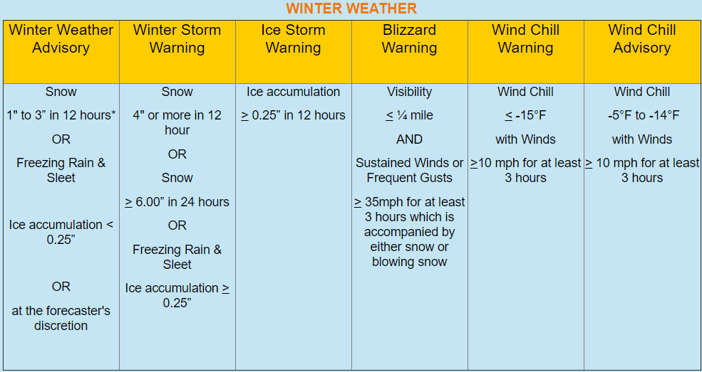
Just now, Icy Hot said:
When did WSW criteria change? I thought it was 6" or more for our area?
From https://www.weather.gov/mrx/watchwarnadv:
-
1
-
2
-
-
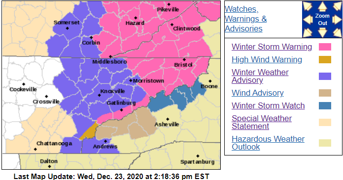
Santa came early...
QuoteHancock-Hawkins-Sullivan-Johnson-Cocke Smoky Mountains- Northwest Greene-Southeast Greene-Washington-Unicoi- Northwest Carter-Southeast Carter-Blount Smoky Mountains- Sevier Smoky Mountains-Lee-Wise-Scott-Russell- 214 PM EST Wed Dec 23 2020 ...WINTER STORM WARNING IN EFFECT FROM 4 PM THURSDAY TO 4 AM EST FRIDAY... * WHAT...Rain changing to snow Thursday afternoon. A brief period of moderate to heavy snow is possible. Total snow accumulations of 2 to 4 inches possible with locally heavier amounts across the higher terrain. Temperatures will also drop below freezing very quickly Thursday afternoon and evening, with any wet surfaces rapidly freezing. * WHERE...Southwest Virginia, northeast Tennessee, and the Smoky Mountains. This includes the Tri-City area. * WHEN...From 4 PM Thursday to 4 AM EST Friday. * IMPACTS...Plan on slippery road conditions. The hazardous conditions could impact the evening commute. * ADDITIONAL DETAILS...The cold airmass and breezy conditions will reduce wind chills across the higher elevations to 5 below zero to 5 above for Thursday night and Friday.
Edit to add: Map hasn't yet updated. Looks like they upgraded watch to warning and SPS to WWA except the furthest SW counties (incl. Hamilton).
Edit 2: To recap: WSW for 2-4", locally higher depending on elevation; WWA for 1-3"; SPS remains for minimal accumulations and hazardous travel.
Edit 3: Map just updated.
-
5
-
-
16 minutes ago, ShawnEastTN said:
My guess MRX will upgrade watch areas to warning, and issue advisory for plateau, and central valley, maybe advisory for Southern valley but probably SPS, mostly out of concern for slick spots from black ice and dusting.
Sent from my SM-G965U using Tapatalk
Adding to this for those unfamiliar or new: MRX generally issues its afternoon AFD, advisory/warning products, and forecast updates around 3:00 pm. For storms such as this, they do have a tendency to push a bit (I've seen as late as 4:00 pm).
-
2
-

Winter Storm Izzy Obs Thread
in Southeastern States
Posted
Nearly identical scene down here, albeit with somehow less sleet.