
LibertyBell
-
Posts
45,019 -
Joined
Content Type
Profiles
Blogs
Forums
American Weather
Media Demo
Store
Gallery
Everything posted by LibertyBell
-

2/13 Significant/Major Winter Storm Discussion & Observations
LibertyBell replied to Northof78's topic in New York City Metro
It's why it's hard to make any conclusions from snowfall data from one location, especially when we don't even know how well they measure the snowfall at the park. In the next storm, if we get one, they could get 10" while the rest of the region only gets 6 lol. -
2/13 Significant/Major Winter Storm Discussion & Observations
LibertyBell replied to Northof78's topic in New York City Metro
There's large parts of Queens that are like that too though. -
2/13 Significant/Major Winter Storm Discussion & Observations
LibertyBell replied to Northof78's topic in New York City Metro
we have a little more than this but it looks similar lol. we actually seem to have more on the trees than we have on the driveways and sidewalks. -
2/13 Significant/Major Winter Storm Discussion & Observations
LibertyBell replied to Northof78's topic in New York City Metro
I'm not sure any of the boroughs will get over 6" but I guess it's possible. 4-6 is good for this storm here -
2/13 Significant/Major Winter Storm Discussion & Observations
LibertyBell replied to Northof78's topic in New York City Metro
That was a mediocre storm for us just east of the city. The park got 26" and we got 13" we were in subsidence hell. I don't consider that an HECS because the 20"+ accumulation area was so darn small. The park total for that storm was higher than my total for the entire season. We also had that storm in December that gave the park 6" and we got nothing but rain-- thats the first time thats ever happened. My most exciting storm that year was the 2" we got in April when the park got 0.1" to hit 40" for the 4th straight year. January 2016 was so much better than that storm and a true HECS (and the third best KU event behind March 1993 and January 1996 overall.) -
2/13 Significant/Major Winter Storm Discussion & Observations
LibertyBell replied to Northof78's topic in New York City Metro
By the time the storm is over Central Park will probably be in the 4-5 inch range. -
2/13 Significant/Major Winter Storm Discussion & Observations
LibertyBell replied to Northof78's topic in New York City Metro
Right, in this sense statistics don't lie we've never had a storm that dumped more than 5.5" of snow with temperatures of 33 and above. I think NYC will end up with 4-5 inches from this storm and probably down here near JFK too. -
2/13 Significant/Major Winter Storm Discussion & Observations
LibertyBell replied to Northof78's topic in New York City Metro
But that's basically the entire city. Even Central Park, although it's grass, it's surrounded by UHI, so you'll usually get higher numbers in surrounding areas outside of the city (except here to the south near the ocean lol.) -
2/13 Significant/Major Winter Storm Discussion & Observations
LibertyBell replied to Northof78's topic in New York City Metro
Not all of Long Island is getting "blitzed" though, here it's a nice light to moderate snow. We'll get to 4" and there's an outside shot of 6" I wouldn't call it "bad luck" I just think it's the natural evolution of the storm. I don't believe in "luck" as you probably know. -
2/13 Significant/Major Winter Storm Discussion & Observations
LibertyBell replied to Northof78's topic in New York City Metro
Same for SW Nassau. I see all these reports of Nassau County getting "blitzed" and it's a nice light to occasionally moderate snow, the "blitzing" must be happening somewhere else lol. -
2/13 Significant/Major Winter Storm Discussion & Observations
LibertyBell replied to Northof78's topic in New York City Metro
The Lady definitely does NOT look happy! -
2/13 Significant/Major Winter Storm Discussion & Observations
LibertyBell replied to Northof78's topic in New York City Metro
of his frozen tear drops lol -
2/13 Significant/Major Winter Storm Discussion & Observations
LibertyBell replied to Northof78's topic in New York City Metro
up to a foot or more in Jim Thorpe! I heard my town mentioned on TWC lol -
2/13 Significant/Major Winter Storm Discussion & Observations
LibertyBell replied to Northof78's topic in New York City Metro
Meanwhile in your favorite town, Boston, it's been raining and 36 degrees lol -
2/13 Significant/Major Winter Storm Discussion & Observations
LibertyBell replied to Northof78's topic in New York City Metro
thats correct, heaviest will end by 12 noon lingering light snows until 2 pm -
2/13 Significant/Major Winter Storm Discussion & Observations
LibertyBell replied to Northof78's topic in New York City Metro
1-2 pm at the latest -
2/13 Significant/Major Winter Storm Discussion & Observations
LibertyBell replied to Northof78's topic in New York City Metro
Jim Thorpe 10.5" Dingman's Ferry 11.0" as per TWC storm reports. -
2/13 Significant/Major Winter Storm Discussion & Observations
LibertyBell replied to Northof78's topic in New York City Metro
yeah it's the banding, you will get yours later lol -
2/13 Significant/Major Winter Storm Discussion & Observations
LibertyBell replied to Northof78's topic in New York City Metro
I think it has more to do with the banding nature of the storm, with the temp what it is, we need heavier snow to accumulate quickly, which is why we started to add up when the heavier bands moved in around 7 AM here. -
2/13 Significant/Major Winter Storm Discussion & Observations
LibertyBell replied to Northof78's topic in New York City Metro
This is exactly what we had at 6:15 am before it went to all snow and the heavier snow came in at 7 am.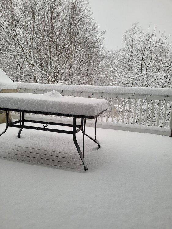
-
2/13 Significant/Major Winter Storm Discussion & Observations
LibertyBell replied to Northof78's topic in New York City Metro
Yeah see you just needed the heavier snow to get in there. I woke up to a coating at 6:15 after it had just changed from a snow/sleet mix to all snow and then it went to heavier snow around 7 and thats when it started to accumulate more rapidly. -
2/13 Significant/Major Winter Storm Discussion & Observations
LibertyBell replied to Northof78's topic in New York City Metro
Maybe the heavy banding just moved in there. There was a coating here on all surfaces when I woke up around 6:15 because before then it was mostly a mixture. Since then it's been all snow and it got heavier so it's at least 2 inches now and a very wet snow because tree limbs are sagging down now. -
2/13 Significant/Major Winter Storm Discussion & Observations
LibertyBell replied to Northof78's topic in New York City Metro
Seidel on TWC just said Central Park has close to 1.5" -
2/13 Significant/Major Winter Storm Discussion & Observations
LibertyBell replied to Northof78's topic in New York City Metro
Yeah but they will be the ones who will probably get close to 8 inches. Since it was mostly a mix all night for us near the south shore, places like JFK should end up with more like 4-6. -
2/13 Significant/Major Winter Storm Discussion & Observations
LibertyBell replied to Northof78's topic in New York City Metro
I guess... but the forecast for 4-8 is a good safe bet right now, we'll see how long it snows for.