
NJwx85
-
Posts
15,544 -
Joined
-
Last visited
Content Type
Profiles
Blogs
Forums
American Weather
Media Demo
Store
Gallery
Posts posted by NJwx85
-
-
Looking like the 12z GFS will be less suppressed this run.
-
 1
1
-
-
Snow ratios with this storm will be in the 6 or 8:1 range outside of the most intense banding.
-
I’m a little surprised with how consistent the models have been this far out with the potential for this weekend. There’s a well positioned high and blocking which obviously opens the door for suppression. It looks like the heaviest snow will be interior Eastern PA and the mountains NW of DC and BWI. The 00z Euro is less suppressed looking than the GFS. Looks like there will be a sharp cut off either way around I-84.
-
1
-
-
Sideways rain here and some minor street flooding. Very windy.
-
This is the NAM's prediction for a few hours from now.

-
 5
5
-
-
-
Still to come per the 18z HRRR

-
 1
1
-
-
Absolutely unloading here in Ramsey, NJ.
-
1
-
-
Moderate to at times heavy rain again here in NW Bergen County.
-
Just now, Allsnow said:
Looks to be dying out mostly…
It's not. Rain is intensifying near Paramus and filling in.
-
7 minutes ago, EWRNJ said:

Looks like some echos showing up again over Jersey
.Yup that is what I was referencing in my last post.
-
A new area of intense rain is developing West of the city over Southern Bergen County.
As many have said, this is far from over.
-
8 minutes ago, Allsnow said:
This event looks over for anyone West of the city. Brooklyn and queens are in trouble
The National Weather Service and just about every model disagrees with you.
-
1
-
-
The 12z HRDPS focuses the heaviest over Westchester and SW CT this afternoon. Sharp cutoff around the I-87/287 split.
-
1
-
-
Just now, Brian5671 said:
3K NAM is ugly

Was just going to post. It develops heavy convection again over some areas that are currently drying out.
-
1 minute ago, Brian5671 said:
yeah worst over by 3-4am just some leftover stuff after that
You do realize that's still like another 18 hours from now?
-
1
-
-
12k 12z NAM and still more to come after this.

-
1
-
-
2 minutes ago, Poker2015 said:
For western areas it is pretty much done...No one really cares about light rain for the next 24 hours that adds up to under 1/2"
For everyone else, far from over...
It's over for areas that were never supposed to get the big rains anyway.
-
1
-
 1
1
-
-
4 minutes ago, nycwinter said:
looks like we could get a break lessening of rain in the next hour or so
The rain is pivoting. All of the dynamics are still focused over the area.
-
1 minute ago, hudsonvalley21 said:
12z HRRR thru 17z Saturday
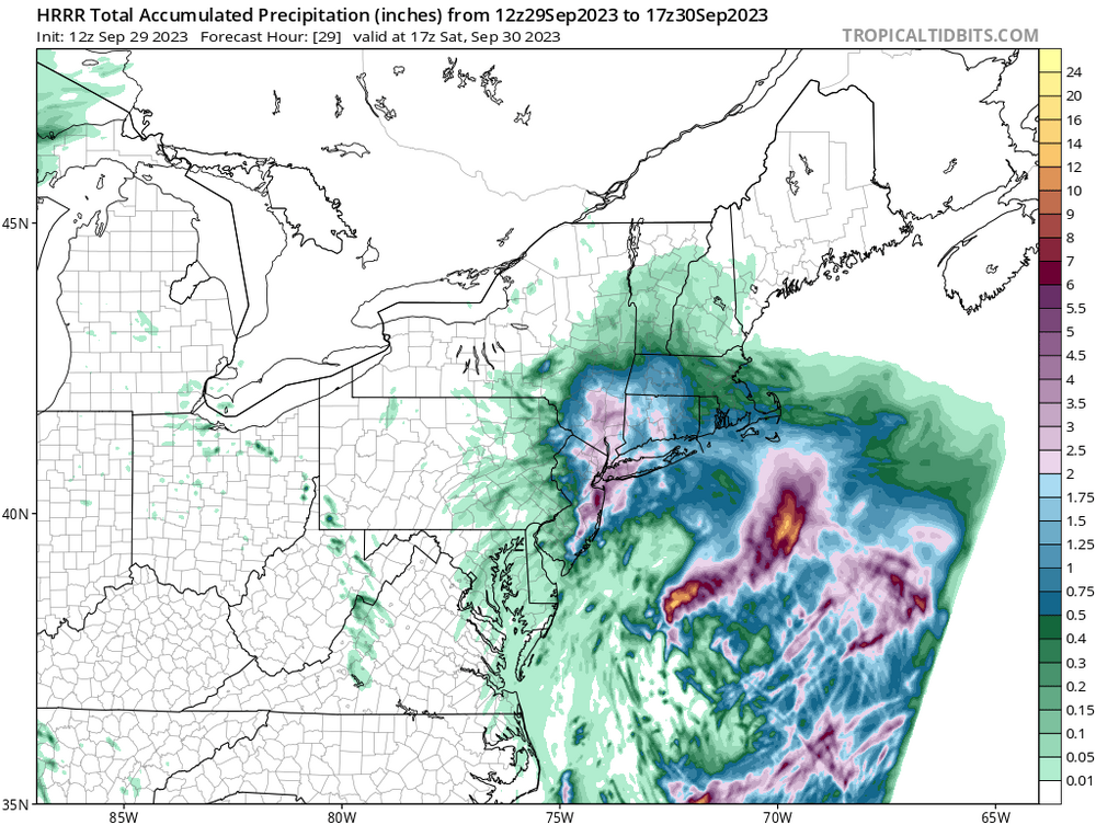
Eastern Orange County is obviously still in it. He was talking about NE PA. Maybe they will get another 1-2" there if another band develops.
-
1
-
-
Just now, ForestHillWx said:
Northwest of 287, I’m glad to be out of the meat of this.
Good luck with clean up to all those getting crushed.
Morris County isn't out of the woods yet. 12z HRRR has another 2-4" for at least part of that area.

-
1
-
-
1 minute ago, weatherbuff85 said:
storm is done for northeast pa
I know you guys had a flood watch but this was clearly a NE NJ, SE NY, SW CT event.
-
3
-
-
5 minutes ago, bluewave said:
Very rough AM commute.
It's 2023 and people still don't understand the concept that it's not a good idea to drive on flooded roadways. This was also well forecasted. People just don't pay attention to the warnings or don't care.
-
3
-
 1
1
-
-
I love how some people are saying how it's almost over when models have it raining until tomorrow afternoon LOL.
-
1
-


Two Mdt to high impact events NYC subforum; wknd Jan 6-7 Incl OBS, and mid week Jan 9-10 (incl OBS). Total water equiv by 00z/11 general 2", possibly 6" includes snow-ice mainly interior. RVR flood potential increases Jan 10 and beyond. Damaging wind.
in New York City Metro
Posted
GFS is a big hit. Heavy snow North of I-78. CAD into the Northern burbs and North Shore. Philly proper is rain.