
NJwx85
-
Posts
15,544 -
Joined
-
Last visited
Content Type
Profiles
Blogs
Forums
American Weather
Media Demo
Store
Gallery
Posts posted by NJwx85
-
-
GFS overall is about the same for NYC proper but better inland.
-
 2
2
-
-
6 minutes ago, HVSnowLover said:
I'm talking about the initial surge. The second wave I guess we'll see if anything actually pans out with that.
It’s better with both.
-
First glance 18z GFS was an improvement.
-
2
-
-
If you look at 3k NAM at 01z sim radar you’ll see a big dry slot over our area with thunderstorms along the NJ coast near the SLP. Those storms will have the potential of robbing us of dynamics and moisture due to subsidence. This is just one model so it’s not necessarily correct.
-
The 18z 3k NAM soundings are a horror show for the coast. 33 degrees in NYC at 23z, okay fine. 35 degrees at 01z, warm layers at 850mb and below 950mb. Up to 37 degrees at 04z. Even Putnam/Dutchess area eventually gets into the 33/34 range. Also 3k not as bullish on Sunday snow as 12k.
A lot of what falls on the immediate coast will be washed away by sunrise.
-
1
-
-
4 minutes ago, HVSnowLover said:
HRRR basically all snow to dry slot. Best case scenario for I95 region through northern LI.
It’s not reliable at this range.
-
2
-
-
The Euro has another big storm MLK weekend.
-
2 hours ago, HVSnowLover said:
I guess the only silver lining of tomorrows storm being less snow is no rapid snow melt concerns except for far northern areas of the subforum.
The snow melt will be in Northern NJ and places like Orange and Rockland that feed the river systems in NJ.
-
5 minutes ago, Brian5671 said:
that's what we wanted in the end--OTS and then an adjustment north which seems to happen more often that not with our bigger storms
The models were showing a well OTS solution and then I think the 12z Euro on 12/24 started the trend back. Models are a lot improved from then. Hard to believe I’ve been on this board since before that storm.
-
1
-
-
1 minute ago, RU848789 said:
I didn't say NYC would get 2-3" as a forecast - I was only talking about the 12Z GFS verbatim likely leading to 2-3" OTG in Central Park.
It depends on location in NYC. 2-4” at CP is a decent bet. JFK is toast.
-
 1
1
-
-
The 12z GGEM was great 20 miles inland and lingers snow Sunday.
-
1
-
-
4 minutes ago, Brasiluvsnow said:
So much still in question with 36 hrs until game time I am sitting here in New City / Rockland County just hoping to see 2 or 3 inches out of this storm because this might easily be a rain event for folks like myself who live North n West of NYC and 20 miles North of the GW bridge,,,,,now back to the model and storm discussion
I’m in Bardonia. 3-5” here, maybe isolated 6-8” if it overperforms.
-
19 minutes ago, MJO812 said:
Or the models bust and we get several inches like we did a few years ago.
I still think that with such a crappy air mass that it’s not going to matter much. Yesterday I was confident in 6-10” up here in Rockland. I think 3-5” is a better call today. We shall see. If it comes in as a wall it could briefly over perform. The problem is the strong Easterly flow along the coast until after the low passes. Over the ocean temps will be in the mid 40’s.
-
Just now, BxEngine said:
Measurements arent made on well traveled roads.
Went back and looked at my original post. I said almost all rain, maybe an hour or two of slop. I stand by that statement. I don’t believe any sites in NYC record over 2” unless things trend differently today.
-
3 minutes ago, RU848789 said:
I know, I said that. I included the 10:1 map, as that shows how much snow is "falling" to illustrate that it's not "mostly rain." Kuchera shows about 2" and I think that's underdone on the model verbatim, as column temps are below 32F on the model until the surface and given decent intensity (once snow starts accumulating, subsequent snow is not affected much by above 32F surface temps, as the actual surface is now 32F snow/slush), even NYC will accumulate maybe 2-3" from that 4.3" of snow falling. That's my informed opinion. I'm not a met, but I guarantee you a PhD in chem eng'g and 30+ years of doing hard science including a lot of work in heat transfer and physical chemistry phase transitions (crystallizations and melting - with several patents in the field for organic molecules) and a lifetime of observing high intensity snow accumulating when people said it wouldn't (think most March/April storms), means a little bit. This is not really a "meteorology" question (assuming the model is correct and no warm nose aloft, just above 32F at the surface), but a physical chemistry/rate question.
NYC receives around 0.3 QPF before issues begin on the 12z GFS. That’s why you will see 2-4” on Kuchera. But that’s mostly on grassy and cold surfaces. And Brooklyn and SI change over very fast.
-
2
-
-
3 minutes ago, snywx said:
12z GFS Kuchera
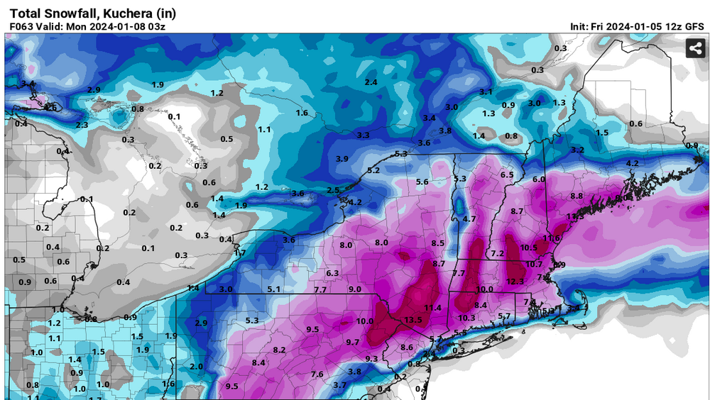
2-4” in NYC, less in Brooklyn and SI. If it really comes down hard I could see that on colder surfaces.
-
1
-
-
2 minutes ago, BxEngine said:
Hes not saying that. He was responding the to “all rain” comment of the gfs with proof the gfs is “seeing” snow. He isnt using the 10:1 maps to show how much central park will receive.
If you look at the 12z GFS soundings you’re looking at a quick flip to rain or mixed precip after only an hour or two. Perhaps it’s too warm. We shall see.
-
6 minutes ago, North and West said:
Come to Morris County! There’s at least one other Mets fan here.
.I grew up in Pompton Plains. My parents still live there. We always did great in marginal storms.
-
2
-
-
3 minutes ago, RU848789 said:
That's incorrect. Plenty of snow "falling" - it's just not clear how much of it will accumulate with 34-35F surface temps; during the thump part, NYC looks to be below 32F (barely) for the whole column, which is good. So verbatim there will be snow and if we can avoid a warm nose aloft (who knows?) I think a few inches (not the 4.3" on the 10:1 map below) is likely - as per the GFS, not a forecast.

You’re using a 10:1 map which is highly innacurate in this storm. Temps are in the mid 30’s. At best you’re looking at 1-3” in NYC and in the outer boroughs facing the water that could be generous.
Look at the positive snow growth.
White rain doesn’t count.
-
15 minutes ago, HVSnowLover said:
Can't the tappan zee get congested during rush hour?
Yes. You have be across before 7am on morning rush hour going South and the evening commutes can be terrible.
-
1 minute ago, HVSnowLover said:
It has 5 inches in the Bronx in like 3 hours. I'm sure it's wrong anyway but if you are lower then 35 with those rates at night it could pile up fast.
I don’t think I’ll even get 5” and I’m 15 miles inland.
-
The totals increased on the GFS in areas that were already seeing all or mostly snow. Nothing has really changed. Locked in now.
-
1
-
-
Just now, HVSnowLover said:
Not terrible even for NYC but will have to come in like a wall like GFS is showing. if it's weak forget it.
https://www.pivotalweather.com/model.php?m=gfs&p=snku_acc-imp&rh=2024010512&fh=66&r=us_ne&dpdt=&mc=
You’re not going to accumulate in the concrete jungle at 35 degrees even in January. Central Park is a different story.
-
Supposedly there’s a period of light snow on Sunday. Low by that point is East of Cape Cod. 6 hours too late but really helps Boston.

Two Mdt to high impact events NYC subforum; wknd Jan 6-7 Incl OBS, and mid week Jan 9-10 (incl OBS). Total water equiv by 00z/11 general 2", possibly 6" includes snow-ice mainly interior. RVR flood potential increases Jan 10 and beyond. Damaging wind.
in New York City Metro
Posted
The GFS is even more amped up for the next system. That one will be the much bigger story than a few inches of snow.