

NJwx85
-
Posts
19,239 -
Joined
-
Last visited
Content Type
Profiles
Blogs
Forums
American Weather
Media Demo
Store
Gallery
Posts posted by NJwx85
-
-
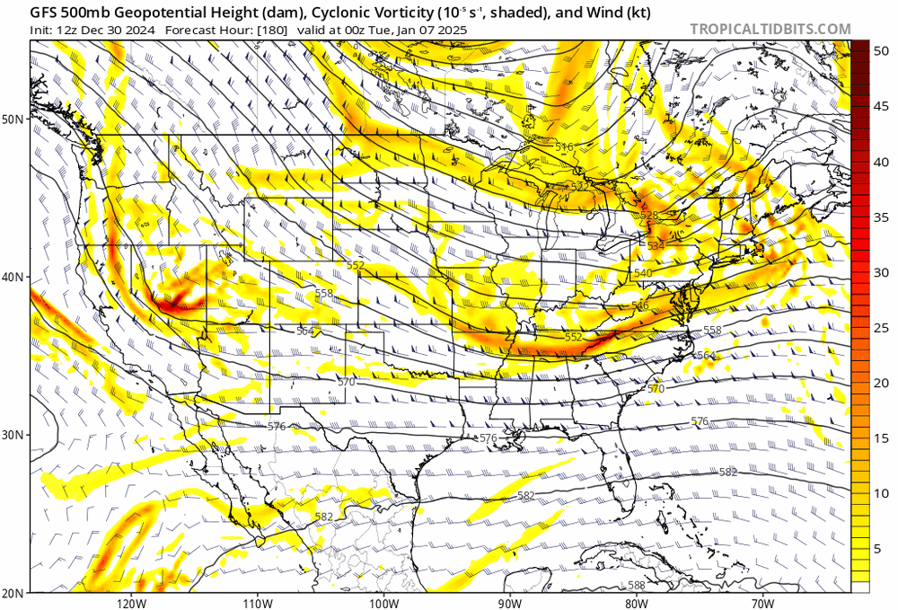
The PV dropping down through New England killed this storm and the one that would have come the end of next week. The energy coming out of the plains won't dig enough and the pattern is flat and overall progressive. It comes down to bad timing.
-
 1
1
-
-
7 minutes ago, MJO812 said:

The warm air out West starts building East on the EPS post day 9.
-
1 hour ago, Allsnow said:
That’s an ugly look at the end of the eps today. Lower hgts start moving into Ak
The cold air in the East definitely begins retreating after the pre Christmas storm.
-
18 minutes ago, MJO812 said:
Finally a weenie storm on the gfs.
That timeframe is the one to watch since all the models have some type of storm. They are also showing plenty of cold air around with a stout ridge out west.
The northern stream piece coming through the upper plains is problematic for areas North of the city because it forces the ULL East prematurely.
-
1
-
-
Naked swirl alert.

-
 1
1
-
 1
1
-
-
11 minutes ago, weatherwiz said:
Holy shit from my friend. Told him to get to nws
This is the one directly West of Boynton Beach correct?
-
3 minutes ago, LongBeachSurfFreak said:
Too little too late. Just too much going against another period of intensification. More then likely the effects of baroclynic forcing. The wind field is definitely increasing and highest winds will probably stay steady state low end cat 3.
This is, was and always will be about a record surge into a major population centersJust to clarify, I wasn't implying that this was going to restrengthen, although some of the hurricane models had modest deepening occurring in the final 12 hours yesterday. But steady state or very slow weakening is likely, and impacts are going to continue to be severe.
-
Deep ring of -80C convection now around the center.

-
2
-
-
5 minutes ago, Radtechwxman said:
Maybe a little of both. But IR appearance is improving and lightning has upticked.
IR loop on Tropical Tidbits is back up. Pretty substantial blowup of -80C tops near the center currently.
-
1
-
2
-
-
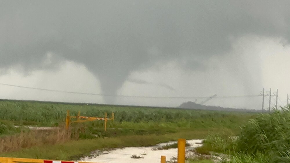
Tornado warning now for Southeastern Orange County and Northeastern Osceola County. Current trajectory should take it very close to KMCO.
-
 1
1
-
-
8 minutes ago, beanskip said:
No way all these tornadoes are going to be able to avoid high population areas forever. What a remarkable outbreak.
Over the next couple of hours these cells will be entering the highly populated I-4 corridor.
-
Just now, nutmegfriar said:
PDS TOR may go over I-95 and through Port St. Lucie. Wow.
Severe Weather Statement National Weather Service Melbourne FL 218 PM EDT Wed Oct 9 2024 FLC085-111-091845- /O.CON.KMLB.TO.W.0032.000000T0000Z-241009T1845Z/ St. Lucie FL-Martin FL- 218 PM EDT Wed Oct 9 2024 ...A TORNADO WARNING REMAINS IN EFFECT UNTIL 245 PM EDT FOR SOUTHERN ST. LUCIE AND NORTH CENTRAL MARTIN COUNTIES... At 217 PM EDT, a confirmed tornado was located near Tradition, or near Port Saint Lucie, moving north at 25 mph. HAZARD...Damaging tornado. SOURCE...Emergency management confirmed tornado. IMPACT...Flying debris will be dangerous to those caught without shelter. Mobile homes will be damaged or destroyed. Damage to roofs, windows, and vehicles will occur. Tree damage is likely. This tornado will be near... Port Saint Lucie, Tradition, and Saint Lucie West around 220 PM EDT. Fort Pierce and Fort Pierce South around 240 PM EDT. Other locations impacted by this tornadic thunderstorm include Collins Park Estates.-
1
-
-
2 minutes ago, WxWatcher007 said:
Currently 2 PDS tornado warnings in central FL. What a tornado day.
I have family currently riding this out in the Disney area. Things should get interesting in that region over the next 4-6 hours tornado wise.
-
Still managing to avoid most of the dry air coming in from the West.

-
 1
1
-
-
2 minutes ago, CoastalWx said:
It should continue to weaken from here on out. But as many noted, the wind field will continue to expand.
The damage is done. Surge is baked in. And the tornado/flash flooding threats inland are prolific.
-
2 minutes ago, WxWatcher007 said:
Someone asked so let’s take a look at radar.

Three things stand out to me:
1) There’s a legitimate tornado outbreak that’s ongoing across the peninsula. Some of these have had very strong couplets. This will continue so even inland folks need to be vigilant.
2) The ERC at least on radar looks nearly complete. As you can see that’s leading to a much larger core. That’s important for who gets the eyewall and perhaps intensity heading into final approach.
3) There’s landfall zone is narrowing on the models but more importantly narrowing on radar. Do not let your guard down slightly north of Tampa or slightly south of Sarasota. As the landfall zone narrows, it’s still critical to pay attention to long term motion, but every wobble becomes increasingly important.
Watch to see if the heading slightly shows its cards after the ERC completes.
At the end of this loop it appears that the old inner eyewall collapses.
-
12z HAFS-B


-
2
-
-
9 minutes ago, jbenedet said:
The 12z NAM is basically a worst case track for Tampa bay. The more east trajectory after moving into the bay really allows the surge threat to get amplified with the Gulf water rushing in behind the circulation.
It’s the NAM but should give some clues directionally on the rest of the 12z suite.
Also shows a swath of 12-18" of rain with locally higher amounts over most of the I-4 corridor. Even though likely overdone, that's going to cause a lot of problems to go with the tornados and tropical storm force winds.
-
2 minutes ago, Intensewind002 said:
I feel like this is the first time I’ve seen a hatched tornado risk with a tropical system
I know that the NAM isn't very useful for tropical systems but look at this forecasted sounding and hodograph from the 12z 3k NAM for the Orlando area.


-
2
-
-
This is not something that you see everyday in Florida. There is potential here for more than just quick spin ups.


-
2
-
-
I'm not an expert but this shear profile doesn't look that unfavorable to me. If it gets strong enough, it might tilt the vortex some, but it's fairly aligned with the track.

-
1
-
1
-
-
2 minutes ago, jbenedet said:
Rainfall threat is not getting enough attention —can already see the PRE well established and intensifying. Incredibly heavy rainfall all day today Tampa on North/East towards Jacksonville
This combined with the tornado threat are going to be major stories away from the immediate coast.
-
2
-
1
-
1
-
-
Milton is so far doing an excellent job of fighting off the shear. As someone else just eluded too, new deep convection (-80C or colder) cloud tops have begun wrapping around the Western half of the system. The ragged appearance this morning was likely due to a combination of the ERC and overall less favorable conditions.
Additionally, dry air intrusion is currently minimal if at all. The models that weaken Milton the most on final approach have dry air wrapping around the entire Southeastern portion of the storm. It will be interesting to see if this happens.
The 12z sounding out of Key West still shows a very moist environment.

-
3
-
-
Over the past hour or so there has been slight warming of the CDO in the SW quadrant but other than that the current presentation is prestine. This reminds me of Dorian at peak intensity.
-
1
-
1
-


Snowfall NYC subforum Jan 6 and OBS if needed
in New York City Metro
Posted
I've had 4 measurable snowfalls already, two plowable and it's only January 3rd. The important thing is that we're in an active pattern so there will continue to be storm chances. We had a period in October and November where it rained like twice in a 60 day span.