
NJwx85
-
Posts
15,544 -
Joined
-
Last visited
Content Type
Profiles
Blogs
Forums
American Weather
Media Demo
Store
Gallery
Posts posted by NJwx85
-
-
-
Just now, NEG NAO said:
18Z and 6Z model runs should be taken with a grain of salt they are using stale Radiosonde data
It's caving to the Euro.
-
 1
1
-
 1
1
-
-
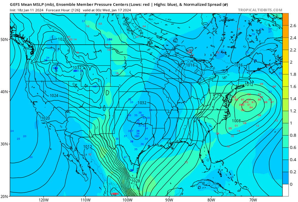
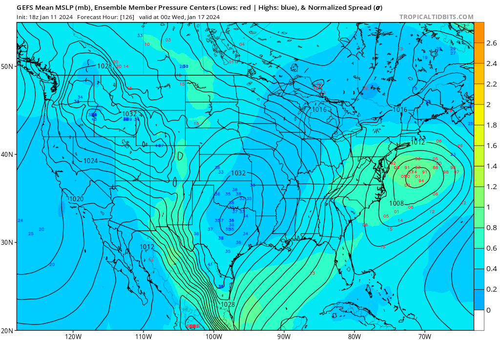
Moving ahead to day four. Looks like the GFS is caving to the Euro.
The Southern vort is too far out ahead of the trough axis since it's slower and your surface low here is way offshore.


-
The only real change on the GFS through 78hrs is that it is slower with the trough.
-
The 00z GGEM is yet another possibility.
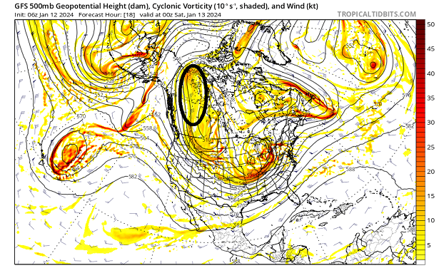
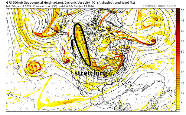
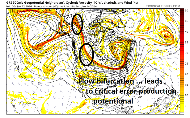
The important Southern stream piece that comes into Oregon tomorrow is seen here off the Northeast coast. It's running so far out ahead of the trough that it doesn't phase in until the system is over Canada and you end up with a very amplified pattern and further West track.

-
3 minutes ago, Typhoon Tip said:
Yeah, it's straight-up a wave addition or not addition taking place between the GFS vs Euro respectively.
Not sure why the EPO relay is different - that's what I was after in describing the original bifurcation stuff. There's excruciatingly tedious albeit crucially important differences in what exactly is sent along and ...well, there we go
If you look at the last four runs of GFS valid 00z Wednesday the model seems to be handling that piece the same way, albeit with slightly different timing and degrees of amplification. But it is phasing it in rather than shearing it out like the Euro. It would be inaccurate to say that the GFS is trending one way or another. It has been consistent at least over the last 24 hours. We will see what happens with the next run shortly.
-
3 minutes ago, Typhoon Tip said:
Yeaaah... I'm not gonna say 'unlikely' from this vantage, but ... that feature, albeit important in general, appears to be handled similarly between the GEFs and EPS... It's running out ahead and dematerializing in the compression gauntlet over the SE.
(that analysis can and probably should be refined further, however)
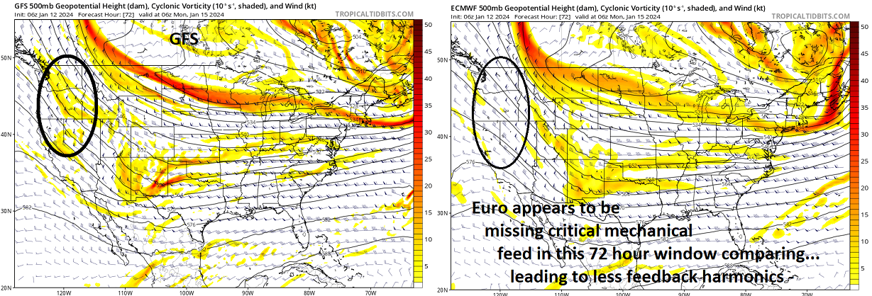
However, the N/stream additional S/W power at mid (500 mb) level 72hours diving S out of western Canada in the GFS that the Euro doesn't have - sort of resembles an 'intermediate jet stream' feature.
The GFS phases ... which leads to more power getting relayed E than the Euro, which doesn't perform this phenomenon because it doesn't "see" that middle stream mechanical influence.
Here...
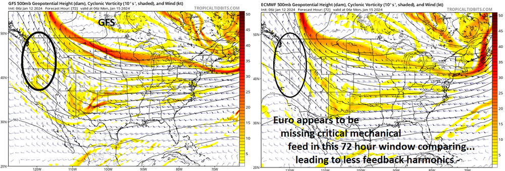
I just didn't want to get too detailed in the previous post .. but all this is ultimately coming from the complex handling over the EPO domain. What is actually going to get send down river determines what's tumbling over the dam
Here is the 06z GFS, you can see that initial piece phasing in which amplifies the trough.

The 00z Euro shears the piece out and you're left with a positively tilted trough.

-
2 minutes ago, NEG NAO said:
in other words the old GIGO theory
In computer science, garbage in, garbage out (GIGO) is the concept that flawed, or nonsense (garbage) input data produces nonsense output. Rubbish in, rubbish out (RIRO) is an alternate wording. The principle applies to all logical argumentation: soundness implies validity, but validity does not imply soundness.
The animated image I was trying to embed in the post wouldn't work for some reason. I don't know what I am doing wrong. I always used to be able to embed directly from Imugr.
In any event, I think the key player is that Southern vort. It will be coming into Oregon tomorrow. If that piece doesn't phase with the incoming trough due to poor timing the system will be either weak or too far offshore. The Euro seems to want to shear it out so there's that too.
-
20 minutes ago, Typhoon Tip said:
This entire handling discrepancy between guidance systems strikes me as data ingest problems.
I've posted this over in the NE thread - but the source/orgin for this event is not arriving via canonical Pacific routing but is actually an inject from SPV decay over the NW Terriorties/eastern EPO domain. It's not abundantly clear that is either well sampled, or even natively handled ( physically..) in the guidance given that processing headache ...
1
2
3
Tip, I think the Southern stream vort that will be coming into the Pacific Northwest late tomorrow night continues to be the key player. This piece shown below on the GFS is well timed and eventually becomes part of the storm over the deep South.

-
Late developing Miller A’s are rough. March 2001 comes to mind. They favor New England not NYC.
-
3 minutes ago, SBUWX23 said:
We don't want it too close as that introduces issues aloft and potentially surface.
Just inside the BM would be fine.
-
1
-
-
1 minute ago, SBUWX23 said:
Some members close to the coast but not a bad look.
Close to the coast is what we want. You want a rapidly deepening system and then the rest will take care of itself.
-
1
-
-
-
18z GFS is going to probably be West of 12z. The southern vort is more amped up than 12z and the trough axis is further West.
-
28 minutes ago, nycsnow said:
Nam showing 60-70mph wind gust and 80s off shore all is well in the world haha
Same type of situation with a squall line feature that moves SW to NE.

-
19 minutes ago, Brian5671 said:
Worthless...just static cling cold and bone dry
My idea of a perfect Winter is 60's and sunny with the occasional snow threat.
-
4
-
1
-
 1
1
-
-
3 minutes ago, NutleyBlizzard said:
The Jan. 20th threat on the EURO is suppressed and OTS as well.
Because you literally have a piece of the polar vortex dropping down. You would be looking at highs struggling to get much above 20 degrees even at the coast.
-
2
-
-
The initial Southern stream vort which will be the major key to this storm is way too fast on the Euro and why whatever storm develops is way out to sea. The incoming trough acts more like a kicker here.
-
2 minutes ago, SnowGoose69 said:
I don't think you're getting any cutter from this but certainly something that tracks from say Nola to overhead NYC is possible which in essence is the sane result ptype wise as a cutter I guess

I don't think this is going West of the mountains but I think a costal hugger or a track right overhead like you said is certainly within the range of possibilities.
-
1
-
-
The key piece here is the Southern vort near Texas on Monday. That has to get out ahead of the deepening trough coming down from the Plains. If that piece is too far out ahead it will get kicked OTS. If too slow we will have a cutter. This is far from a slam dunk. Right now it's a bit too far out ahead so the system deepens more after it passes us and closes off over Maine. First shot at a true Miller A this season.
-
1
-
 1
1
-
-
5 hours ago, wdrag said:
Storm impacts possibly a little less than that of Tuesday night but am not convinced. Rainfall definitely less, but forces some of the small streams back into minor flood and the large mainstems - they may crest higher this weekend than what has already occurred.
Wind: ensembles and various models slightly less but not convinced. Power outages develop west of the Apps and on the Apps ridges Friday afternoon then pockets of damaging wind in our area later Friday night.
A touch of snow the first hour or two Poconos extreme nw NJ, Catskills-Litchfield Hills between 5 and 9PM Friday then the period of heavy rain.
Problem will be the Passaic River which is still rising and not forecasted to crest until late tonight or early tomorrow morning. Any additional rain will prolong the major flooding into early next week as indicated on the hydrograph predictions.
-
11 minutes ago, SnowGoose69 said:
The closest thing I recall where 2 massive cutters happened and a few days later that was snow was probably 2/2/96, there were 2 huge cutters between 1/20-1/27
After the Mother of all snowstorms a few weeks prior.
-
4 minutes ago, MANDA said:
This pattern better break soon. Any more of these 1-2" rains in any kind of rapid succession is going to be a big problem for rivers across our area.
This is typical of a moderate to strong El Nino. Warm, wet pattern with lots of storm chances and not much cold air.
-
A lot of the river areas in Northern NJ were resort areas for people in the city during the 40's and 50's when people would vacation out in the country. That is when a lot of these areas were built up. It was a quiet period without a lot of major flooding and you could actually swim and fish in the Pompton river without fear. My Dad grew up in the Sam's Maple Grove section of Lincoln Park and would tell stories about swimming in the river as a kid. Then the 60's were bad with floods with 1968 being the worst. And then you had an almost 20 year quiet period until the big flood of 1984 which set records that were only broken with Irene in 2011. That's the problem. You can sometimes get a 10-20 year stretch with no issues and then a period like this happens with two major floods in less than a month and the potential for more in this pattern. The house my Dad grew up in was finally knocked down after Irene. My Grandfather and three of my Dad's uncles helped build the majority of the houses back there. Not much of what was there is still standing.
-
1
-


Potential extensive winter event, I-95 west and with again a chance for NYC first inch(es) of snow Mon or more likely Tue Jan 16, 2024 (serves as OBS thread as well)
in New York City Metro
Posted
As I have been saying all along, it comes down to whether or not the Southern vort is timed well with the incoming trough. If it's too fast like the 12z ECMWF and now 18z GFS shows, the trough will kick it out. If it's too slow it could phase early and you could get a super amplified trough and rain at the coast. Has to be timed perfectly. Still time for this one but there is no denying that this was a major nod towards the Euro.