
NJwx85
-
Posts
15,545 -
Joined
-
Last visited
Content Type
Profiles
Blogs
Forums
American Weather
Media Demo
Store
Gallery
Posts posted by NJwx85
-
-
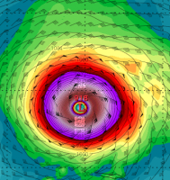
Just to give an idea on the massive size of the wind field. Also, notice the increased winds along the coast thanks to the tightening gradient between the high and Lee

-
 5
5
-
-
3 hours ago, Ed, snow and hurricane fan said:
The Gulf and Caribbean are staying quiet at least through the next two weeks per the GFS ensembles. Little to no activity through mid October for the Euro weeklies. Good for Florida. I don't see why the Caribbean would be so quiet, although weeklies suggesting EPAC action which would be suppressive of the Caribbean.
Part of the reason is that conditions have been favorable in the MDR so systems aren't making it that far West.
-
2
-
-
https://x.com/michaelrlowry/status/1701793885108777040?s=46&t=wnL9UkNay47lChNZhqU2Pw
How do you embed tweets now?
-
1
-
-
Eaten alive by dry air on the NW side
-
Why is it having such a hard time clearing out the eye?
Outflow is ridiculous and it's still over sufficiently warm water.
Shear appears low and don't see a lot of dry air intrusion.
-
1
-
-
1 minute ago, brooklynwx99 said:
ECMWF is east of 00z

I was comparing to yesterday's 12z run. It's West of that but East of 00z.
-
1
-
-
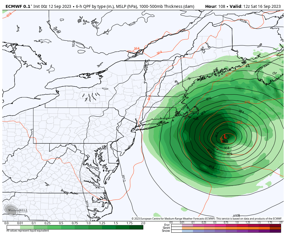
Euro with landfall in Eastern Maine at 120hrs

-
 1
1
-
-
12z Euro is slightly West of the 00z run at 96hrs. Close enough to bring strong winds to the New England coast.
-
It really is astounding
3 minutes ago, olafminesaw said:The Euro no longer is trying to deepen back to a cat 4, so we'll see if that has any effect on the track
The 12z Friday position is nearly identical to the 00z run.
-
1
-
-
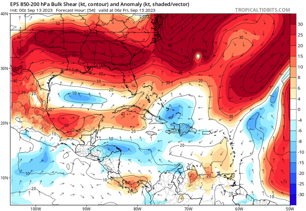
Also to note is that the GFS has moderate Southwesterly shear building West of potential Nigel thanks to deep East coast trough.

-
12z GFS has a major hurricane one week from today Southeast of Bermuda and heading West with ridging overhead. It needs to miss the weakness leftover behind Margot if it has a chance of making it West of Bermuda.
-
1
-
-
12z GFS is about 50 miles or so SW of the previous run at 90hrs. It's decently slower and on a trajectory for a landfall in extreme Eastern Maine.
-
37 minutes ago, STILL N OF PIKE said:
It seems it’s stuck in a perpetual ERC because neither eye wall will take over or completely . Not sure what needs to happen but all I can say is whatever it injested Saturday am really Seems to have messed it up . It’s been under rocket fuel and can’t sort itself out
The outflow has really improved the last few hours and the eye appears to be clearing out some. The HAFS is predicting a more or less steady state system until Saturday morning when it starts to feel the cooler SST.
-
2
-
-
1 minute ago, jerseyshorewxguy said:
why would anyone in NYC be losing sleep over this storm?
It wouldn't take much to bring strong winds into the region and if he lives in Brooklyn he might be susceptible to coastal flooding.
The 06z GFS which was pretty far offshore still brings near TS force winds to the Eastern end of Long Island. The Euro brings those winds much further West. Still a wait and see.

-
1
-
-
1 hour ago, WxWatcher007 said:
What an eye developing on Lee.


Hurricane models showed this nicely. Huge expansion of wind field and truck tire eye. Not much strengthening though due to larger size.
-
1
-
 1
1
-
-
1 minute ago, Torch Tiger said:
We'll see. I've always been on board with a swipe or perhaps near-miss of SNE, that's easily doable. The wild solutions, never say never but I'll stay away for now.
Looks like the 12z EPS mean landfalls in Eastern Maine.
-
4 minutes ago, Torch Tiger said:
Yeah that looks good, 250mb jet near/ over St. Lawrence River which is typical of NE hurricanes
I don't think this is going to landfall in the US anymore than you do, but a glancing blow is still definitely possible.
-
16 minutes ago, Torch Tiger said:
Yeah you are assuming the motion will continue, but there's no reason to think that
If you look at the steering flow there's no reason to believe it just stops moving NW from this point.

-
3
-
-
3 minutes ago, Torch Tiger said:
It doesn't hook into NE...you're assuming
If you put it into motion it's headed in that direction at a fairly good speed.
-
1
-
-
12z HAFS-A is hooking left into SNE as the run ends.

-
1
-
1
-
-
12z HWRF is similar to the globals with a likely landfall in Eastern Maine or Nova Scotia imminent. Tropical storm force winds make it to the Cape by Saturday afternoon.

-
1
-
-
Fairly strong consensus building for a landfall in down East Maine or Nova Scotia. Not really too concerned about New England. That area is used to seeing strong winds during winter storms.
-
 1
1
-
-
12 minutes ago, RevWarReenactor said:
Looks like the NWS isn't buying the hook west yet, either that or they are downplaying it for now until things get closer.
New England is within the cone of uncertainty. That should tell you all you need to know.
-
2
-
-
6 hours ago, Floydbuster said:
The long-range GFS has a 1996 scenario with Hurricane Lee taking a track similar to Hurricane Edouard '96 and a new system slamming into North Carolina as the worst strike since Hurricane Fran '96.
This season just feels so much like '96, especially with that constant wave train.
Most, but not all of the 06z GEFS members steer the next system safely out to sea. Threat is not zero but is minimal at this time.
-
2
-
Category Five Hurricane Lee
in Tropical Headquarters
Posted
Yup, 12z Euro is East. Looks like the GFS and hurricane models now.