Frog Town
-
Posts
1,029 -
Joined
-
Last visited
Content Type
Profiles
Blogs
Forums
American Weather
Media Demo
Store
Gallery
Everything posted by Frog Town
-
Real nice dude. What happened to us cheering for each other.
-

Winter 2020-21 Medium/Long Range Discussion
Frog Town replied to Hoosier's topic in Lakes/Ohio Valley
-
Winter 2020-21 Medium/Long Range Discussion
Frog Town replied to Hoosier's topic in Lakes/Ohio Valley
But when they do, they DO -
Answer always lies in the middle. Which would be a good solution if you combine the two.
-
save NW Lower MI, and the Eastern Kentucky coal fields...
-
Ok. Makes sense now. I live in Toledo, so It was a win for the glacial ridge and northwest.
-
New Years Eve 2007 and we had a similar set-up. You all remember what that storm did?? It wasn't good for the lower lakes.
-
Winter 2020-21 Medium/Long Range Discussion
Frog Town replied to Hoosier's topic in Lakes/Ohio Valley
Are you saying a Low could form on the frontal boundary? -
Winter 2020-21 Medium/Long Range Discussion
Frog Town replied to Hoosier's topic in Lakes/Ohio Valley
That was my Freshman year in college at Siena Heights University and I remember it being cold, but not much snow. I do recall having somewhat of a back loaded winter that year. -
Winter 2020-21 Medium/Long Range Discussion
Frog Town replied to Hoosier's topic in Lakes/Ohio Valley
Lake Michigan Special right there! -
Winter 2020-21 Medium/Long Range Discussion
Frog Town replied to Hoosier's topic in Lakes/Ohio Valley
Had to swap out Taco Tuesday. -
Winter 2020-21 Medium/Long Range Discussion
Frog Town replied to Hoosier's topic in Lakes/Ohio Valley
Dude! How did you know my family is watching this tonight for Pizza Movie Night! -
Winter 2020-21 Medium/Long Range Discussion
Frog Town replied to Hoosier's topic in Lakes/Ohio Valley
Yes, I understand, but it's a needed variable to what we are into. -
Ummm. Anyone in the southern lakes notice the high in Ontario throwing us a bone, Eh!
-
Winter 2020-21 Medium/Long Range Discussion
Frog Town replied to Hoosier's topic in Lakes/Ohio Valley
Bah Humbug! It's a cold sign at least. Polar Vortex is definitely looking janky! -
Winter 2020-21 Medium/Long Range Discussion
Frog Town replied to Hoosier's topic in Lakes/Ohio Valley
Well hellloooo there! Santa is paving the way....for cold at least. -
Winter 2020-21 Medium/Long Range Discussion
Frog Town replied to Hoosier's topic in Lakes/Ohio Valley
Yes, it's the name, but re-he-he-heally for the lower lakes?!?! -
Winter 2020-21 Medium/Long Range Discussion
Frog Town replied to Hoosier's topic in Lakes/Ohio Valley
That's NOT the spirit! lol. -
Winter 2020-21 Medium/Long Range Discussion
Frog Town replied to Hoosier's topic in Lakes/Ohio Valley
Would definitely say it's a step in the right direction. -
Winter 2020-21 Medium/Long Range Discussion
Frog Town replied to Hoosier's topic in Lakes/Ohio Valley
I'm sure some in here follow Judah Cohen and his Polar Vortex Science. Last year at this time he was thinking a SSW would trigger a weakening polar vortex leading to cold for the second half of December. He was hinting at the same thing this past week. Will this trump, or change the ++EPO signal we seem to be getting?? -
What's the climate like in Cali with regards to RH% That seems to be what's increasing case load
-
Winter 2020-21 Medium/Long Range Discussion
Frog Town replied to Hoosier's topic in Lakes/Ohio Valley
Can you please elaborate if this is for the better?? Thanks! -
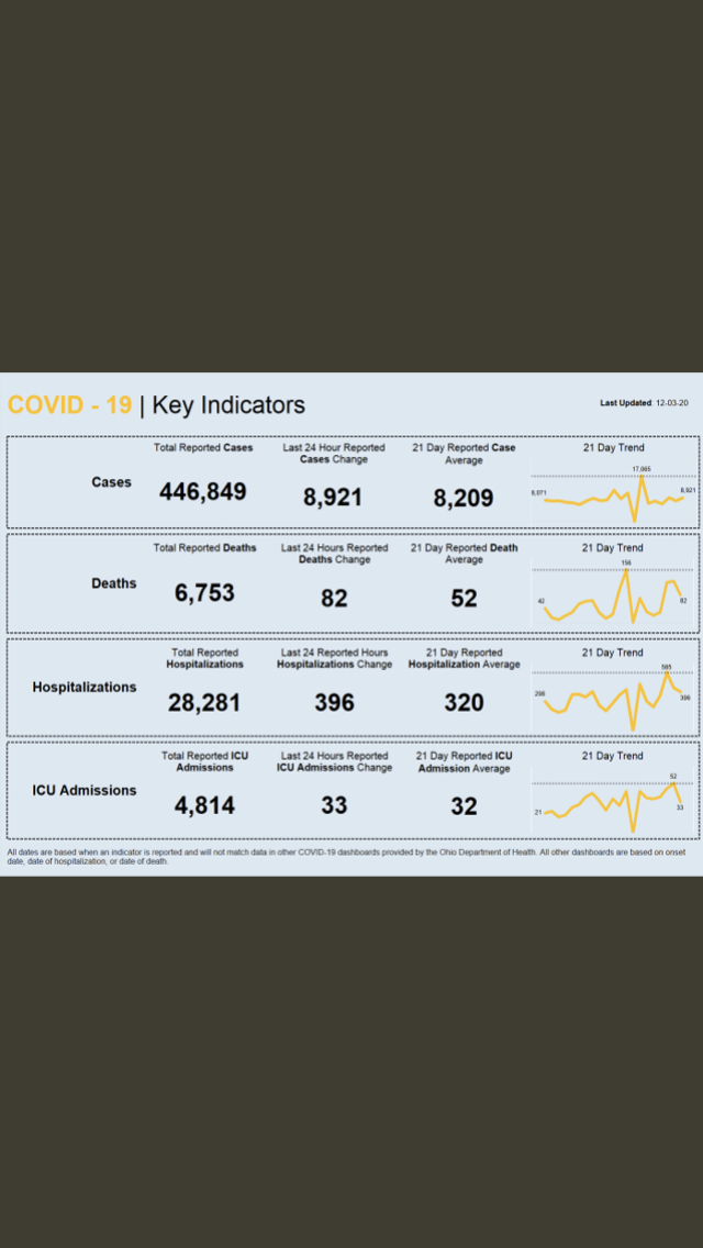
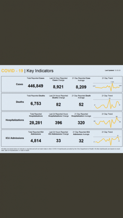
That can’t be right because in Ohio we had like 400 hospital increase
-
Winter 2020-21 Medium/Long Range Discussion
Frog Town replied to Hoosier's topic in Lakes/Ohio Valley
Rea-he-he-healy -
Today is going to be BAD.