
leo2000
-
Posts
569 -
Joined
-
Last visited
Content Type
Profiles
Blogs
Forums
American Weather
Media Demo
Store
Gallery
Posts posted by leo2000
-
-
10 minutes ago, snowman19 said:
Region 4 hasn’t been this cold in over 16 years
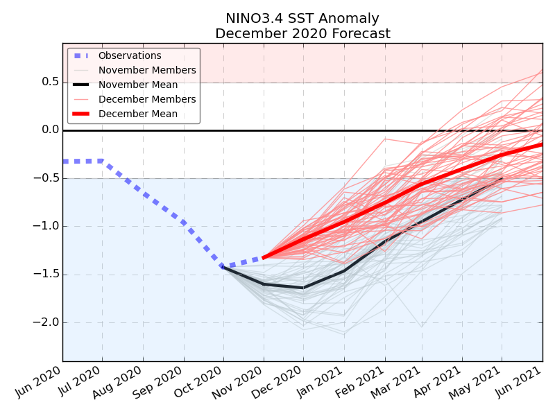
Enjoy it Met DT has posted just awhile ago on another sub forum. He showed a model directly from ecmwf which shows a dramatic weakening of the Moderate La Nina.
IN MAJOR DEVELOPMENT the ecmwf enso model shwos DRAMATIC WEAKENING of the Moderate La Nina.
It is hard to understate how BIG this is...or COULD be...
a rapidly weakening La Nina... in essence a WEAK La nina combined with SSW EVENTt
-
 3
3
-
-
2 hours ago, psuhoffman said:
The EPS still shows a brief window around Dec 16-18 before the pac puke arrives if something can amplify before the cutter vacates the 50/50 region. After that looks ugly. Silver lining is the Atlantic side stays ok. Unlike last year there are hints, including signs of a SSW, that the NAM might not be a complete lost cause this year. The pac looks a mess. I kind of assumed that was coming. But last year the Atlantic side was hostile too. That’s a no hope situation. If we get some Atlantic side help this year we should get some opportunities. It will still be a struggle and a fight. Nothing will come easy. But it’s not hopeless like last year.
Pacific not completely hostile we have a -WPO.
-
 1
1
-
1
-
-
3 minutes ago, ORH_wxman said:
Looks a bit like the last 10 days of dec 2007 or so...there just enough WPO to push the lower heights further south into Canada and the western US.
That was an above normal period for us but it did have some threats and a couple advisory events.
Seems like the MJO is stuck in phases 4-5. Do you think the negative WPO will help offset some of the positive EPO warmth?.
-
Mmm the EPS is suppose to tank the NAO negative which would fight the pac puke.
-
Some Christmas hope!
New run
 ]
]

Old run


-
4
-
-
1 hour ago, RUNNAWAYICEBERG said:
On to January.
On to February then March then to next summer and so on. Winter seems like it doesn't exist anymore.
-
 2
2
-
 1
1
-
-
47 minutes ago, bluewave said:
I am guessing that the -EPO forecasts are having trouble due to the MJO 4.

New run

Old run

That pesky MJO in phases 5-6 ugh
-
27 minutes ago, weathafella said:
Kind of nice dateline ridge potential with what looks like nao help to offset? Cold is plentiful

-
-
46 minutes ago, CoastalWx said:
More of an east based -NAO...ridge poking into eastern Greenland.
Hmm seems the EPS 12Z is heading in the wrong direction it was showing cold around this time period yesterday and has backed off of it.
-
Question if its a big if but if a split happens what would that do to La Nina/ MJO?
-
Just now, CoastalWx said:
EPS still had the mid month look. We take.
What is happening here?. Looking likes warm warm in the East mid month.

-
1
-
2
-
-
13 minutes ago, bluewave said:
I guess model mayhem is the end result when the pattern tries to shift from more Niño-like to more Niña-like in the same month.
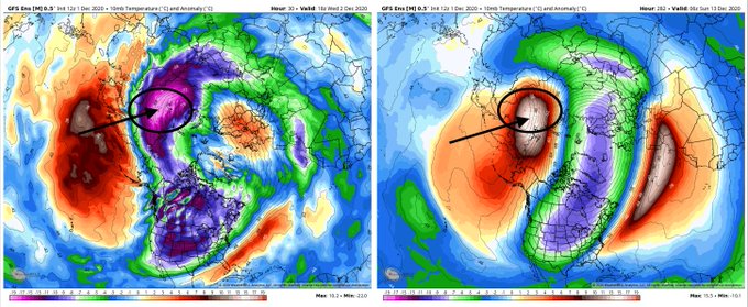
Maybe or could have been because of the Polar Vortex taking hits and being stretched.
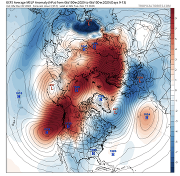
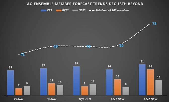
MAJOR trend from 49% to 70% of the 103 global ensembles in 12 hrs for a -AO from 12-13-20 and beyond.
Colder risks mid month drastically increasing.
Details in my video coming in http://Bamwx.com video here soon.
#natgas #oott #energy
-
1
-
-
4 minutes ago, bluewave said:
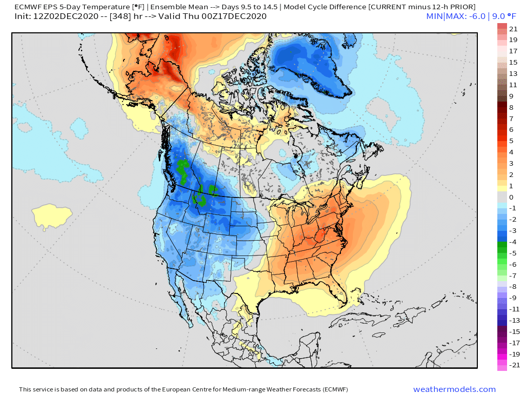
Day 11-15 is still outside the best range for the EPS. Especially when the model is jumping back and forth on storm details at day 4-5. Those short term errors get magnified longer range. All the guidance has a retrogression of the ridge axis from Western Canada to Alaska and then back to the Aleutians. The strength of the -EPO before it weakens will determine our overrunning potential. Then we also have to watch the strength of the ridge east of New England which the models have been underestimating. Even if we see some weakening of the PV, it may not show up until January. But those start forecasts can be very uncertain unless we are dealing with a very strong long range signal which hit us March 2018.Wouldn't think be a Major SSW event?
-
30 minutes ago, frd said:
- EPO / perturb the PV / NEW EPS = Yeah baby !
Maybe I can get a response from you but if this comes to fruition. Would this mute the La Nina base state from coming back?. Also mute MJO from going into phases 4-6. Thanks.
-
How is the 12z EPS long range?
-
Merry Christmas the Sh$$ter was full.
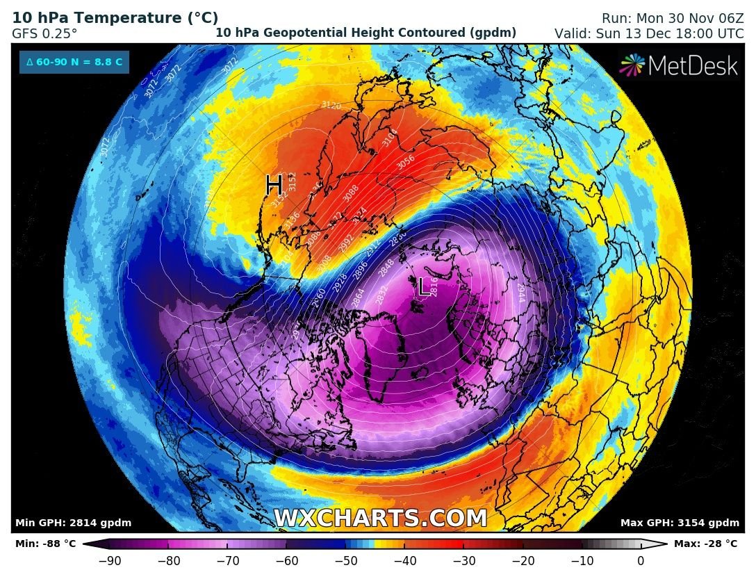
The new GEFS is starting to see a *potential* sudden stratospheric warming event within the next 10 days. As the North Pacific pattern starts to feature some blocking (-EPO) its going to doing some serious work on the #PolarVortex. This is something to watch closely. #natgas -
See new Tweets
Tweet
Another extended-range update from ECMWF with the ensemble-mean predicting the transition to a persistent weaker-than-average stratospheric vortex beginning mid-month. I'd take that...
-
1
-
-
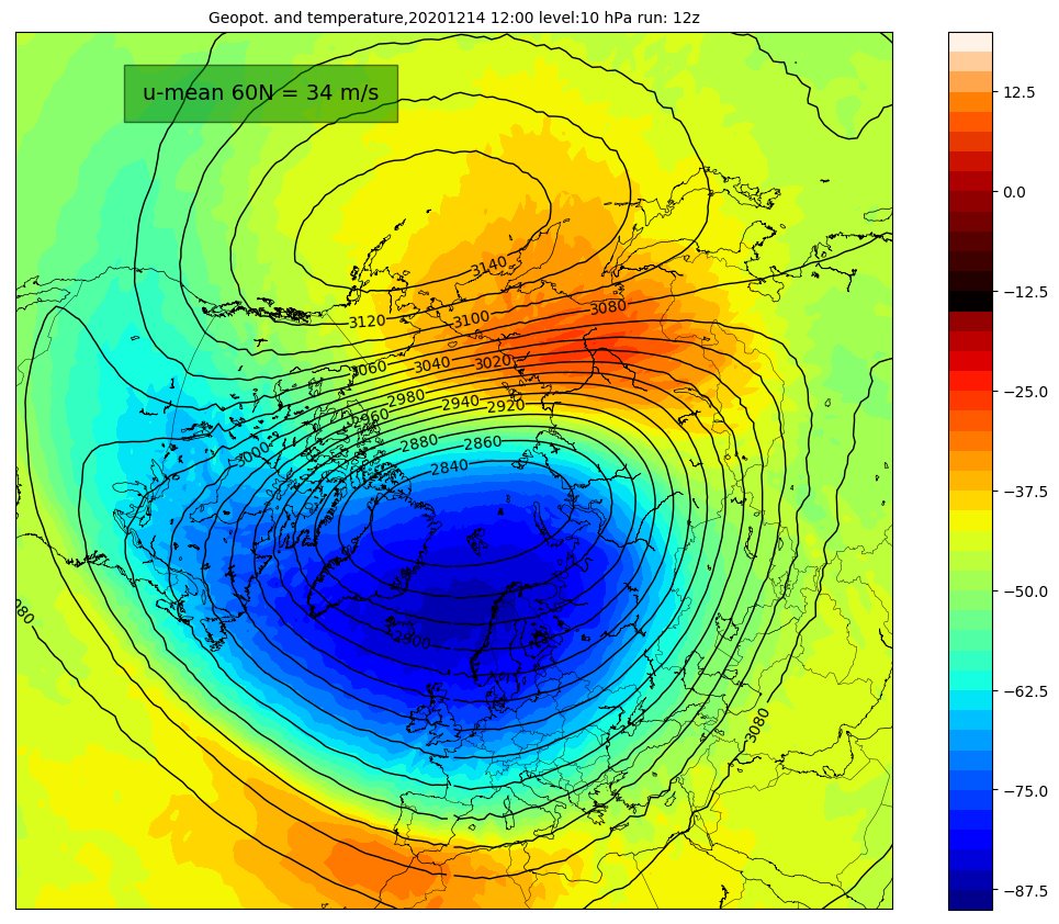
Hey guys is the PV splitting?. https://www.stormgeo.com/weather/articles/what-is-the-polar-vortex-and-what-does-it-mean-that-it-has-split/
-
32 minutes ago, ORH_wxman said:
Yeah that was a big shift from prior ensembles runs...directly attirubted to the height rises in the AK/Yukon region....pushing a pretty stout PV south into Hudson. We'll have to see if other guidance goes that direction.
How is the long range looking on the 12z Euro?.
-
54 minutes ago, ORH_wxman said:
No it doesn’t. Link?
I think they are talking about the MJO going into phases 4-6 and the Strong La Nina base state. But there is a lot of uncertainty there.
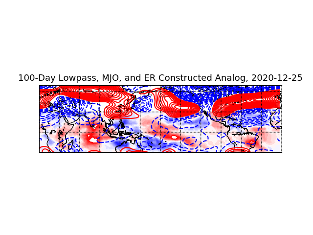
The same statistical algorithm that weeks ago projected the upcoming wild pattern in the eastern US now projects this for the end of December. (Shown is 200 hPa height anomalies, red positive). ( Courtesy of Paul Roundy on Twitter). -
20 minutes ago, WxUSAF said:
After a couple days of pattern breakdown at the end of the EPS, the end of today’s 12z run still looks pretty good. -AO/-NAO and a ridge just off the west coast. Broad CONUS trough east of the Rockies. Looks overrrunning like.
Any -EPO. Really need to get rid of that Pac puke.
-
Just now, CoastalWx said:
Man, not a good day today. Maybe people sobering up from food and alcohol bender.
Uncle Leo is here to the rescue. People need to be patient it will snow eventually. I know it's hard with Covid and last winter's disaster.
-


December 2020 General Discussions & Observations Thread
in New York City Metro
Posted
Enjoy the suppose record cold 3.4 Enso as the chart I sent you shows a dramatic weakening of the La Nina.