
leo2000
-
Posts
569 -
Joined
-
Last visited
Content Type
Profiles
Blogs
Forums
American Weather
Media Demo
Store
Gallery
Posts posted by leo2000
-
-
The CFS

-
 3
3
-
-
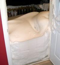
I really hope we have a White Christmas this year for once.
-
1 hour ago, Hazey said:
Snow stated little more than two hours ago. Already 3.5” down. Heavy snow with little wind. Great snow growth. Seems to be the theme of this system. Haven’t even got into the meat of the storm yet. Impressive and worth the wait.
#NovaScotiaStrongYes indeed very heavy snow bands to come too.
-
3 hours ago, Bostonseminole said:
we need some new clowns lol.. it's always the same.. where is Leo?
I never knew I was a clown lol.
-
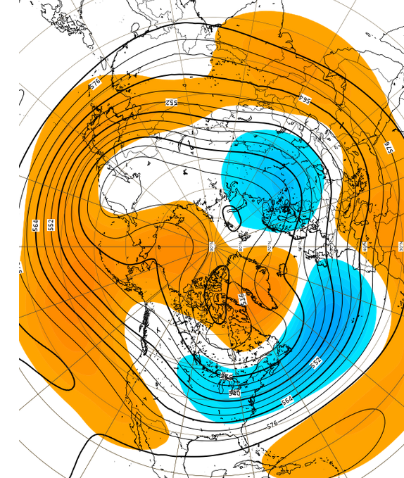
Talk about a epic blizzard if this happens. Most likely won't but fun to look at.

This one is closer it could happen

-
 1
1
-
-
The Euro Weeklies look very good!


-
1 hour ago, RUNNAWAYICEBERG said:
They are stealing all of our snow!
-
Just curious what teleconnections did we have for the 2014-2015 winter because as we all know it was very epic.
-
1 hour ago, CoastalWx said:
EPS tends to be the better guidance so therefore that is favored. However, that is not always the case, and a compromise can always happen. But the GEFS are less skillful.
Hasn't the GEFS been more right though this winter so far?. Plus there was an improvement on the 12z EPS vs 00Z EPS. With some higher heights over AK. Also the -NAO suppresses the Southeast Ridge
 Replying toMJO signal (independent from the base state, which resists this outcome), suggests a western N. America ridge: http://http://www.atmos.albany.edu/facstaff/roundy/waves/rmmcyc/indexmjo.html
 -
43 minutes ago, ORH_wxman said:
No real changes? All systems go for 2nd half of the month. Let’s hope it delivers.
The weeklies still trying to bring La Nina pattern on Feb 2nd onward. Though a -NAO looks to persist.
-
It looks like all of February will be very good as well.
January update to
SEAS5 showing strong support for a negative NAO during Jan & Feb. I suspect that the shift from previous forecasts arises from the now sig. weakened strat vortex, for which there was not a strong signal in the Dec fcst (although some suggestion).
-
2 minutes ago, ORH_wxman said:
They look the same for the most part. Been pretty consistent actually. Week 3 is the peak weenie pattern but it looks good through the end of the month and then it goes to more classic La Nina February. Though keep in mind by that point we're in week 5/6 which have little skill.
Here's week 3.
Thank you very much!. Very nice.
-
How are the weeklies looking?.
-
2 hours ago, Damage In Tolland said:
There’s question if he’s even got a met degree. All he does is look at GFS stuff. Find a tweet that he doesn’t use it
He's a Climatologist http://www.judahcohen.org/
-
1 hour ago, Typhoon Tip said:
Not a good look for Jan 8-12th either...
Two days ago I admit I saw some alarming signals in there for either a top tier potential ... maybe an aggregated series but wow! The 240 hour Euro and GFS ... eradicate the NAO... and show signs of speeding the flow back up again. Interestingly ... the CPC tele's sort of relfect that ... with AO/NAO recoveries going on out toward the end. Better hope the Pac reorients or heh -
doesn't mean winter's over... no, just that said "alarming signals" .... are no longer there. hahaha... Maybe we'll see them come back... maybe this opens the door to a whole new paradigm of delivery ...
I can make one prediction that is above the 90th percentile accurate ... if this two-step head game goes on ... I predict I am going to start fantasizing for not only another 80 F week in mid February ...this time, I want the NAO to go f- itself in March. Leaves us the hell alone. That way we can just commit to an early spring/warm season and finally cash-in on GW in a meaningful way around here... lol
What are you talking about Tip?. The GFS op models?. If so they can't handle the blocking going on. The NAO west based block is going nowhere's and the pacific is improving a lot too.


-
Nice snowstorm in my area today!.
-
2
-
-
6 minutes ago, WinterWolf said:
So this might be the real deal as far as a real split goes this time then...? Hopefully if it does split, we get some of the affects on our side of the pole/globe also?
Yes it looks like it for real this now. Two weeks after a SSW peaks (in the Siberian cases, only)
This information and model is from Met Michael Ventrice on Twitter. He is also doesn't have a weenie bias. He calls it how he sees it.
-
 1
1
-
-
1 minute ago, WinterWolf said:
Is this going to cause a “True Split” of the Polar Vortex? Or is this just another situation where it takes some big jabs and then reconsolidates?
it is very very unlikely to reconsolidate it is taking massive hits.
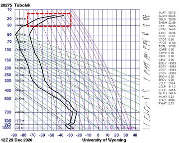
Sudden stratospheric warming is underway! Here's a selection of radiosonde ascents from Russia & Mongolia at 12Z today, which captured the warming in the mid-stratosphere. http://weather.uwyo.edu/upperair/sounding.html…Replying toIf the ECMWF is correct, we have good conditions for a SSW with downward impact! European blocking is the best precursor for a NAO- response (see https://doi.org/10.5194/wcd-1-373-2020… with and L. Papritz), and it's predicted for the first week of January! https://apps.ecmwf.int/webapps/opencharts/products/extended-regime-probabilities?forecast_from=latest…-
1
-
-
1 hour ago, Typhoon Tip said:
Where is this warming event being observed - what source. How is it being defined.
It is coming from Siberia it's called a Siberian SSW.
-
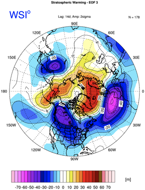
it looks like the Major SSW is trying to couple with the 500mb pattern as it improves.
-
 1
1
-
-
Looking better in the long range.


-
1
-
-
4 minutes ago, MJO812 said:
JB thinks a snowier pattern will begin the 2nd week of January
Not just JB I realize he has a major bias toward cold and snow but Michael Ventrice also supports the view too. He is a more neutral Met or another follows what the models show.
-
1
-
-
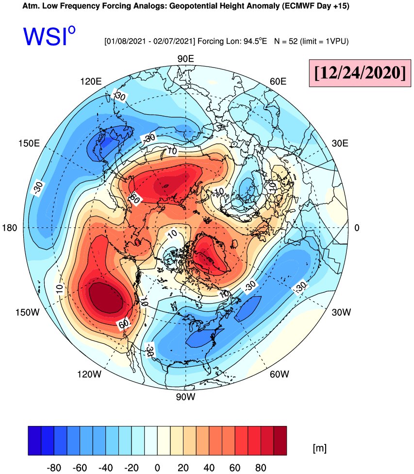
That is why we need help from a Major SSW as with La Nina's usually favor lower heights over Alaska. The La Nina is expected to weaken which should help with higher heights over Alaska. Which is what we want for a -EPO to develop. This 12z GEFS looks real nice. The affects of the Major SSW is already effecting Europe. It will wait until after January 5th for the Eastern US/Eastern Canada. We should be in business by Mid January.
-
3 minutes ago, snowman19 said:
You’re just repeating the hype from the weenie mets on twitter. Literally every winter from November through March they scream about the massive SSWs and SPV splits that are coming. Snake oil salesmen. Fact is, despite what these clowns say, SSWs and SPV splits don’t automatically mean a huge arctic cold and snow dump into the eastern US. In fact, it may just benefit Eurasia and do nothing here, as has been the case numerous times in the past. But they have everyone fooled to believe that every SSW or SPV split event is going to turn the east coast into an arctic tundra. Most of the time they are wrong in predicting these events to top it off, they either don’t end up happening or happen on a very muted scale. It’s a real bad sign when you are depending on SSWs and SPV splits to cause large scale favorable pattern changes, a lot of things are usually going really wrong at that point.....
I think this winter may resemble 2014-2015 if so that when the polar vortex was responsible for a cold and snowy winter.
-
1
-
2
-


November Discussion
in New England
Posted
First of all, it's only November. Sir the major pattern doesn't look like it's coming to materialize. As it's a fake -EPO not a real one like last winter. But then again this is the 2nd year of a two year La Nina. If things are going to go real bad and we get some really warm temps might as well get them now. So just before Christmas the goods can come.