
leo2000
-
Posts
569 -
Joined
-
Last visited
Content Type
Profiles
Blogs
Forums
American Weather
Media Demo
Store
Gallery
Posts posted by leo2000
-
-
1 hour ago, Greg said:
Close to 35.0". Interesting!
 Love to see the drifts.
That post was in error probably 24 inches of snow without the drifts.
-
4 minutes ago, EastonSN+ said:
I guess all in all February will hinge on whether or not we repeat record RNA vs. Typical RNA.
Plus if the RNA returns what's to say the current pattern does not come back as well.
Will be fun to watch unfold.
I don't expect the RNA to be record territory this time.
-
 1
1
-
 2
2
-
-
1 hour ago, DavisStraight said:
How much do you have so far?
It's hard to say with all the drifting 24 inches probably.
-
2
-
-
We are having a bad blizzard here. The snow was incredible this morning couldn't get the doors open. Environment Canada put us in a Winter Storm Warning but honestly should of put us in a Blizzard Warning. We had very little rain and ice. Shades of one of the bad blizzards that hit my area in 2015.
-
3
-
-
14 minutes ago, bluewave said:
The latest EPS weeklies continue the cold -EPO +PNA for the rest of January. The model begins to shift back to a more Nina-like pattern in early February. Moves the current Nino-like forcing from the Central and EPAC back to the Maritime Continent. So the temperatures begin to moderate then. Any delay in the La Niña forcing to return would keep the colder pattern going a while longer. Plenty of time to check the actual status of the tropical convection once we get to the beginning of February.
Jan 17-24
Jan 24-31

Jan 31-Feb 7

Yeah probably rushed there I am thinking at the earliest February 20th onward before we revert back to La Nina base state. Given how strong the -EPO and +PNA will be. Patterns like this one take a long time to break down.
-
 1
1
-
-
1 minute ago, JC-CT said:
And they used to walk to school uphill both ways.
That's true man there was not even snowplows back then.
-
2 hours ago, Hazey said:
Yeah i'm not sure what that kid is talking about. I've lived here my whole life (48yrs) and it most certainly has rained in January... multiple times.
I think my mother knows what she is talking about she is 68 years old. She has a very good memory and remembers things very well. Also very good at remembering phone numbers too. I am 37 years old. My father too when he was alive used to also tell me there was no such thing as rain, freezing rain or even ice pellets back then just snow. I think rain is obviously a common theme from March- November but not really for December, January and February.
-
 2
2
-
-
1 minute ago, JC-CT said:

Not in my latitude. I guess Climate Change is responsible for this. My mother told me 2014-2015 winter was like the winters she had when she was growing up.
-
10 minutes ago, CoastalWx said:
How many times did we say this? LOL. Weenies gonna ween.
Lol are you telling me it's normal to get rain in January?. Lol.
-
1
-
 2
2
-
-
I know many are mentioning how good of a pattern this is. But if it's a very good pattern for snow and cold we wouldn't be have cutters showing up periodically. 2014-2015 didn't have any cutters. All big coastal blizzard like snowstorms.


-
2 hours ago, ORH_wxman said:
Then the pattern goes to hell around mid-Feb but obviously that is clown range on the weeklies.
Haha, the CFS has a completely different take on the pattern.

-
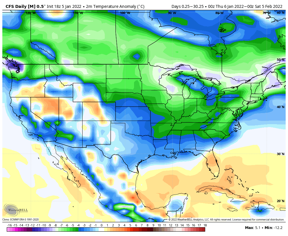
1 minute ago, snowman19 said:
Simple reason, we had a major SSW last year and the La Niña never coupled. Neither one of those happened this time
The La Nina never coupled this year. The CFS Daily looks nice
-
1
-
1
-
-
1 hour ago, snowman19 said:
It looks like the cold could possibly hold into late January with the MJO stuck in phase 7 with -GLAAM. Will be interesting to see what happens the tail end of the month, like post 1/25:
Most La Nina have warm Februaries?. They didn't last year and yes we had a La Nina last year too.
-
I think this storm could be a whopper of a Blizzard two feet of snow possible.
-
2
-
1
-
1
-
-
3 hours ago, ORH_wxman said:
Yeah EPS went back to pants tent pattern....you could see the OP run doing it to at the end of the run there around D10....and the EPS gets better and better beyond that as well.
So we get a decent +PNA, -EPO?. +NAO to -NAO?.
-
If this run is correct that would be my hunch come true. Given how bad the Pacific has been do we really think we are going to have a positive PNA and negative EPO. Nah looks like a positive PNA there and a big positive EPO.
-
3 hours ago, 40/70 Benchmark said:
CFS actually nailed December.
They did?.
-
32 minutes ago, snowman19 said:
As Allsnow was. But in all honestly, that pattern is temporary, enjoy it while it lasts and hope it produces
What happened last winter and yes it was a La Nina last year too. The La Nina is slowly starting to die out.
-
20 minutes ago, Typhoon Tip said:
Basically … a general shit winter with an interlude or two of tacit favorability
La Nina’s are supposed to be front loaded winters.
Yet another ENSO climate failure … It’d be really funny if the winter is back loaded or even mid
Winters are usually back loaded now anyways. Front loaded winters seem to be a thing of the past.
-
1
-
1
-
-
Any favorite pattern change lol is over before it even begins according to these guys.
 I generally agree. While the GEFS has been overzealous in the medium range of late trying to bring back the GOA ridge, the lower freq evolution of the troposphere & stratosphere suggest a prototypical late winter Nina +NAM/-PNA state returns by the end of Jan-early FebQuote Tweet
 Dr Simon Lee@SimonLeeWx· 5hWith the N Pacific ridge migrating poleward, GEFS spies the onset of the Alaskan Ridge regime for early-mid January -- bringing colder weather more widely to the US & ending a potentially record-setting Arctic Low regime. However: the Arctic Low regime then comes straight back... twitter.com/SimonLeeWx/sta…Show this thread
 -
Just now, WinterWxLuvr said:
It’s not a height map. So …
Oh would of loved to see the height map.
-
1
-
-
2 minutes ago, psuhoffman said:
But the pac looks good…isn’t that what everyone wanted???
Where's the cold arctic air on that map though the whole continent is flooded with warm Pacific air. If it was a good Pacific pattern you wouldn't have low heights over AK. That looks like a positive EPO, positive PNA pattern. PNA good but EPO not good.
-
Just now, ORH_wxman said:
Man the GEFS and EPS are pretty different in the N PAC in the 11-15. GEFS has a nuclear EPO ridge…almost 2015-Esque. EPS are really lowering heights in AK though there is still some cross polar flow to the N of AK
Typical EPS Bias with the lower heights in AK. As far as the GEFS goes I really hope it's right. Yes, many references going around this winter will be like 2014-2015.
-
1
-
-
2 hours ago, poolz1 said:
Just going off today's RMM plots...
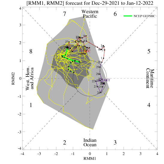
Ok you know how unreliable those are right?. I really really hope your right though.

January 2022 Obs/Disco
in New England
Posted
Any Mets on here thinking this big Volcano Eruption could cause a flip in the ENSO from La Nina to El Nino?. Apparently, volcanic eruptions I have heard do help cool the Earth's Climate.