

eyewall
-
Posts
13,328 -
Joined
-
Last visited
Content Type
Profiles
Blogs
Forums
American Weather
Media Demo
Store
Gallery
Posts posted by eyewall
-
-
11 minutes ago, NorthHillsWx said:
If anyone needs to see a board wide meltdown head over to the NYC sub forum right now
Yeah they are whining about 6-10 and we are happy to hang on to a dusting lol.
-
 4
4
-
-
The Euro is just better at modeling the Raleigh screw zone
") Honestly it didn't make much sense to me though.
Honestly it didn't make much sense to me though.
-
 2
2
-
-
49 minutes ago, wncsnow said:
.thumb.png.282a9b5941f31fb946d115b58fec5c6d.png)
LES off Smith Mountain Lake in VA?
")
-
 1
1
-
1
-
-
-
4 minutes ago, Sandstorm94 said:
Significant cutback

Sent from my SM-S115DL using Tapatalk
Yeah I will be honest, it is looking more like shite today.
-
1
-
-
-
It is looking like a brief deform band event as the low begins to crank and pulls away. DC weenies won't like this one very much. Looks like a nice hit in SE Mass. It is a shame we can't pull a big one from this but it's better than nothing I suppose.
-
It still looks like it may be better than the previous couple of runs but yeah it is weaker with the thumbnail ridge in the west.


-
Wave 1 in a similar position to the NAM at this stage on the GFS:

-
Even if I pick up 2 inches in an hour or so with a deform band and that is it, that is much more fun than 12 hours of microflakes.
-
6
-
 2
2
-
-
1 minute ago, CaryWx said:
Granted the NAM has been fairly consistent for what--4 runs in a row now?
Still, this just makes me want to see the 12z LR model runs. The diversity in solutions will most assuredly need to start consolidating soon. We have all the RAOBs ingested now right?
I believe so. This 12z GFS will be the big one in terms of where we are going with this I think.
-
2
-
-
If I have the time I may attempt an early call map after the 12z suite.
-
1
-
-
-
1 minute ago, GunBlade said:
Yea leaves less energy behind than the last run, much closer to 00z run. Phase looks at little stronger but little too late to jackpot central NC.
Really the Coastal Plain jackpots with decent numbers cutting off west of US-1

-
1
-
-
-
1 minute ago, TARHEELPROGRAMMER88 said:
NAM is now hundreds of miles east with the low
If you are looking at HR57 that isn't the storm. That is a different "L" being indicated. The phase hasn't occurred yet.
-
2
-
-
So far it is looking like the southern stream wave is slightly behind where it was in recent runs. It is fairly consistent though.
-
-

Wave over the 4 corners-
1
-
-
Typically in La Nina February marks the end of hope for snow. We are definitely going to warm up next week but yeah could get one more shot at it. Either way it gets tougher with sun angle to be sure.
-
Well at this point I think the consensus is a near miss with minor accumulations for most. Basically it is far northeastern NC through the Tidewater and up on this one.
-
4
-
-
1 minute ago, CaryWx said:
You think the Triangle had another 4hrs or so?
At least enough time to approach 10"
-
I am liking this trend like everyone else. Let's see the GFS climb aboard next!
-
2
-
1
-
-
.png.90d7180f0f2fb6b5cf78f7e1ecf26245.png)
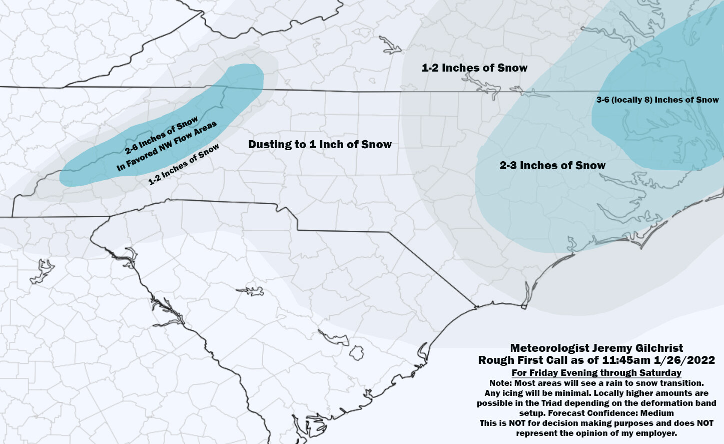


Potential 1/28-1/30 2022 winter storm
in Southeastern States
Posted
The Euro ensemble mean should make the NYC folks feel better. As for NC, well not so much:
