

eyewall
-
Posts
12,552 -
Joined
-
Last visited
Content Type
Profiles
Blogs
Forums
American Weather
Media Demo
Store
Gallery
Posts posted by eyewall
-
-
2 minutes ago, HKY_WX said:
Thinking 3 to 5 is still a good bet for raleigh. Don't see much yet that wold alter the forecast.
Starting off with frozen precip is a solid beginning.
-
 1
1
-
-
As I post that a mix of IP/SN is falling by hillsborough and the beltline
-
 1
1
-
-
RAH is talking about a cut back:
Very few if any changes this morning. Looks like a later
start to the snow across the north as the precipitation has not
quite filled in across the north this morning. The longer these
areas remain precipitation free, the more temperatures will be
allowed to rise and the lower chances for significant snowfall
amounts. Generally, expect snow accumulation to largely hold off
until after 4 PM this afternoon, with increasing chances for snow
through the evening and early overnight. However, there is still a
good bit of uncertainty with respect to amounts.
-
Just now, NCsandhills said:
No precip here so far, but obs thread has reports of flurries/sleet in Garner near Clayton...
Yeah we will see if it can eek its way in soon. I know there have been epic virga busts in Raleigh before.
-
1
-
-
Starting to have concerns about dry air for RDU
-
 6
6
-
-
2 minutes ago, FLweather said:
Wow radar looks impressive.
Good luck guys and gals. Considering how crappy this winter has been.
Rooting for a over preformer.
so far QPF doesn't appear to be an issue. We just have to watch those temps.
-
1
-
-
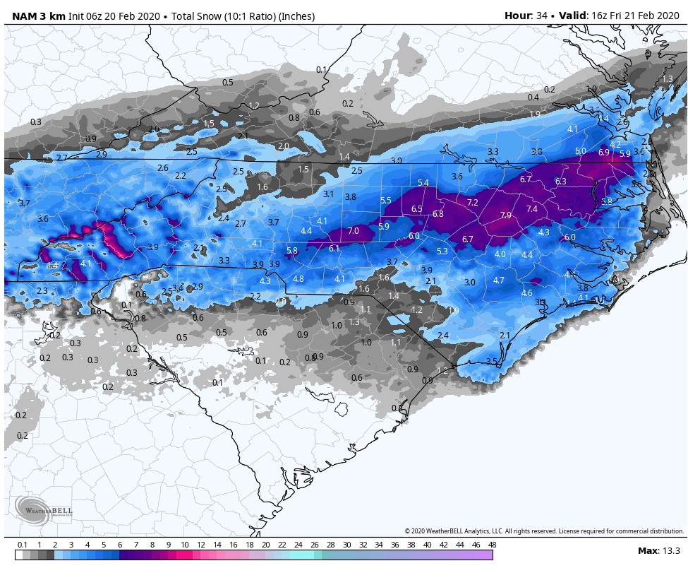
6z 3km NAM (10:1). Kuchera is slightly higher but not by much.

-
2
-
1
-
-
This is the pre-event panic phase for most. Time to just wait and see.
-
5
-
 4
4
-
 1
1
-
 1
1
-
-
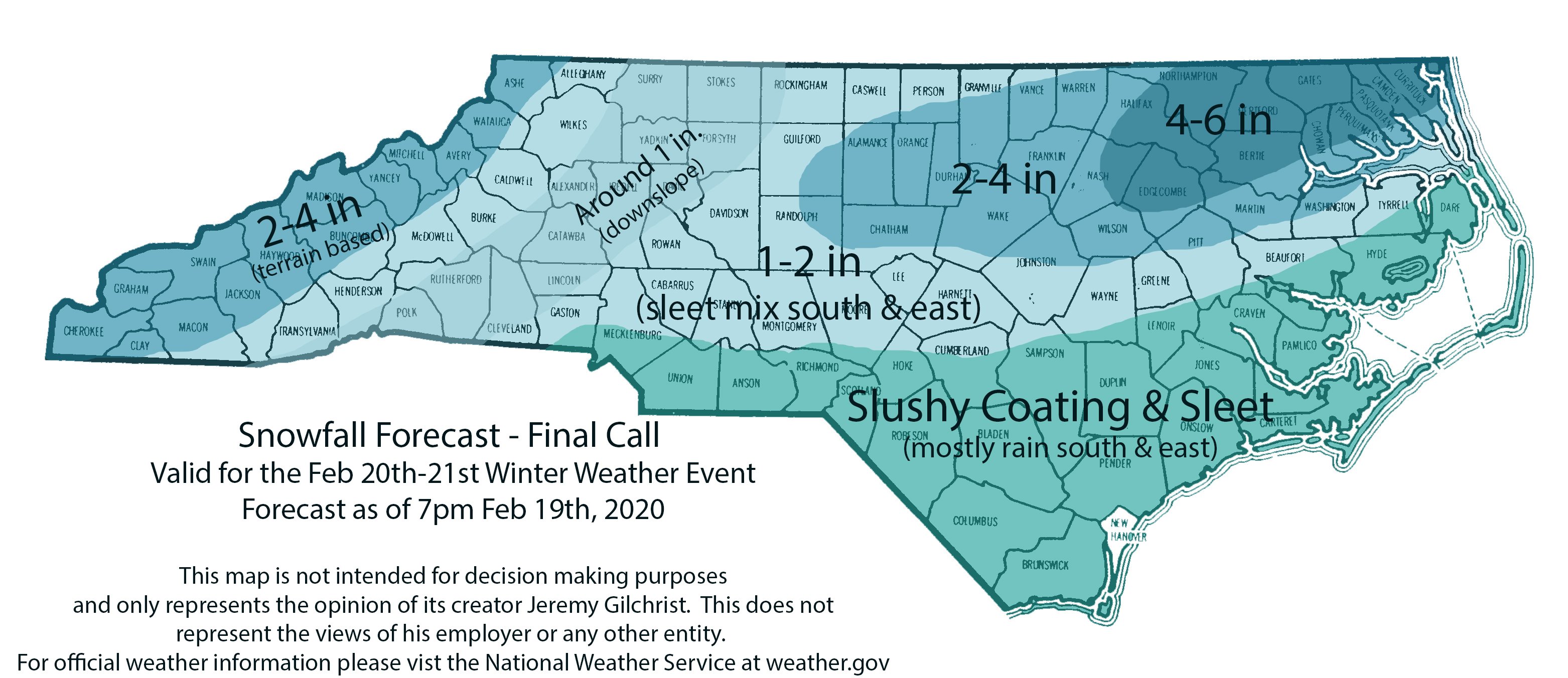
My final call:
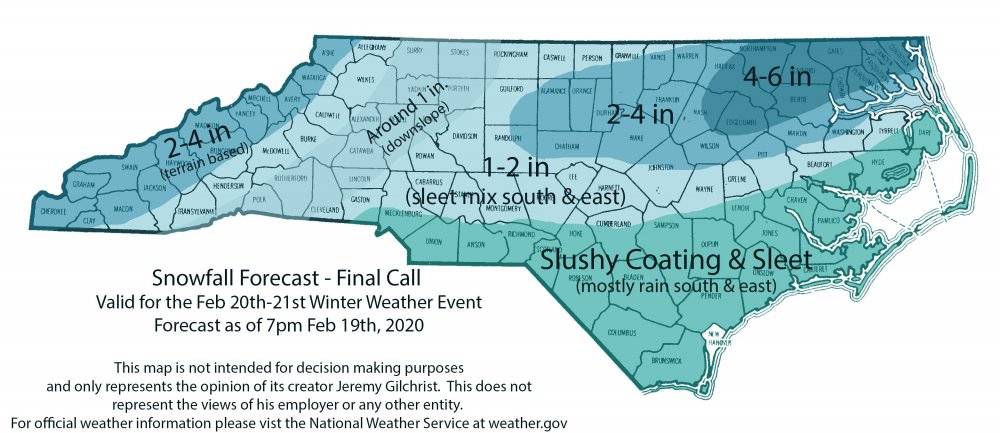
-
5
-
2
-
-
Sleet reported in Garner as well.
-
Just now, Snownado said:
Sleet with temps near 50. Pretty interesting
I have seen sleet in the 40's plenty of times.
-
1
-
-
There have been a few sleet reports north of Raleigh already today as an FYI.
-
4
-
2
-
-
I never said it was a final call but yeah the sleet concern is always a real one in central NC.
-
1
-
1
-
-
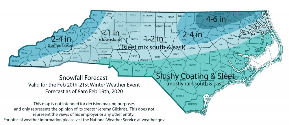
My latest call map (risky knowing bust potential is high):
-
My rough call:
-
1
-
1
-
1
-
2
-
-
NWS Raleigh is not very enthused and is mainly east of 95 with it.
-
2
-
-
2 minutes ago, griteater said:

It is pretty much holding for the time being.
-
1
-
-
17 minutes ago, SnowDawg said:
Guys the NWS will stay conservative as long as they possibly can, sometimes to their own peril. I had a forecast of 0 inches and R/S mix 12 hours before getting almost 6 inches a little over a week ago.
We are all hoping to be Nammed for sure LOL. Afternoon discussions will be crucial.
-
3
-
-
12 minutes ago, DC2Winston said:
Would you include the Triad as part of the lee side in this setup? Or a bit further West in the true foothills...
I don't think it would be as much of an issue in Winston and GSO.
-
1
-
-
Just now, calculus1 said:
Thanks for that, eyewall. Ugh. The mountains give (in CAD events), and the mountains take away (in storms from the NW and (sometimes) W directions). Such is life in this incredibly interesting micro-climate. =)
Overall, I'm still pretty psyched by this storm, though. This has the most potential all year long.
Yeah ideally I would like to see everyone get in on it but we know how it works down here. This was much easier in my few years in BTV.
-
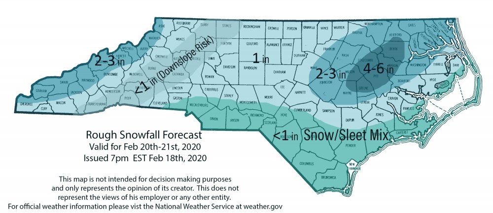
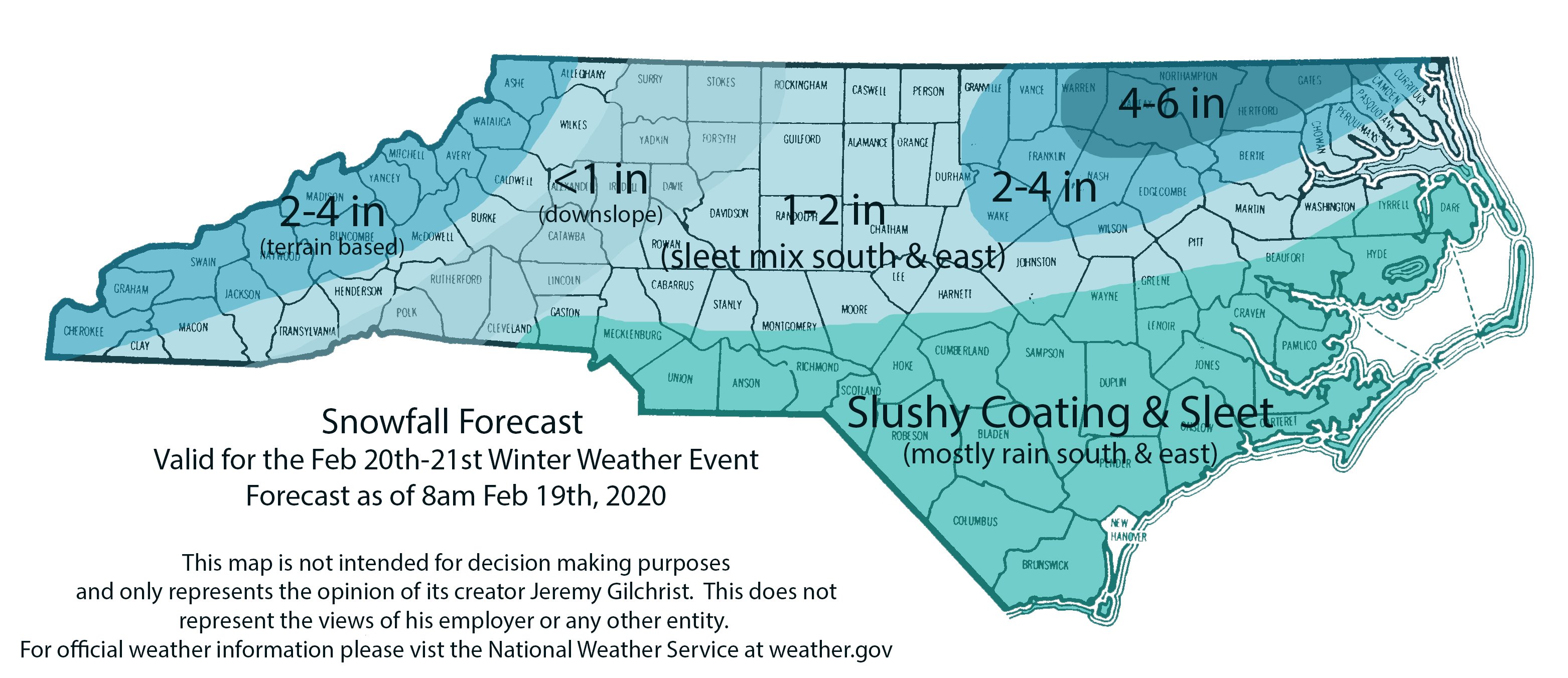
As of now I think a 1-2 inch event would be about the best the Triangle would pull from this. Drier air with the high position will be a concern. I think there will be some in the lee of the mountains that get shafted somewhat by downsloping.
-
2
-
3
-
-
5 minutes ago, FLweather said:
That would certainly shut up Eyewall for RDU.
That would be fine by me but I seriously doubt these numbers verify. If we get a dusting that is a win this year though.
-
Lock that one in
") . Nice frontogenisis
. Nice frontogenisis
-
1
-
-
19 minutes ago, NorthHillsWx said:
I think you will be able to tell the state of the Thurs system entirely based on whether this thread turns "hot" after the 12Z model runs tomorrow
Most likely the sanitarium will become much more active.
-
1
-
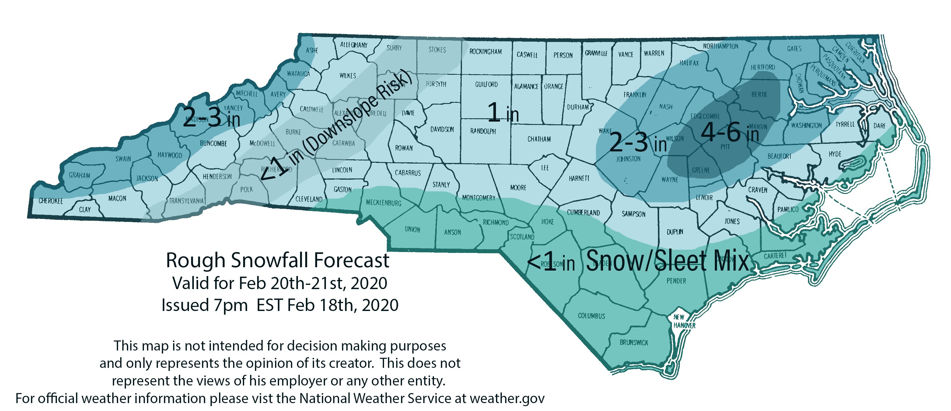
Feb 20-21 OBS ( all bets off)
in Southeastern States
Posted
First flakes in Raleigh at 1:55pm where I am. Mixed with IP.