

sbnwx85
-
Posts
1,445 -
Joined
-
Last visited
Content Type
Profiles
Blogs
Forums
American Weather
Media Demo
Store
Gallery
Posts posted by sbnwx85
-
-
43 minutes ago, ILSNOW said:
18z Euro

About 3 mb stronger and just a tick north than 12z. Maybe the start of a trend?
-
Updated mood:

-
 1
1
-
-
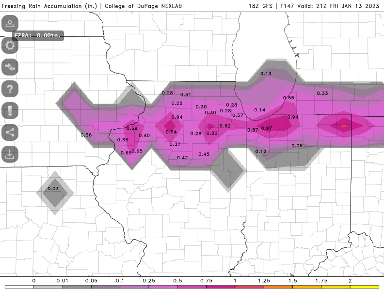
Based on recent trends this should end up being an advisory level event here. But we should build up a decent snowpack with the clipper following right behind it.
-
Even IWX is jaded by this winter.
Not much to speak about here until the next weather system lurks
midweek. Seeing how winter has gone so far, and the models with it,
I`ll take the glass half-empty approach by saying that a notable
shift in storm track is still woefully possible. (Recall there will
be 16 model runs between now and Tuesday morning for those that are
run 4x/day). For now, given the blended forecast approach, I`ll keep
POPs a tame as possible as to not over promise on snow or rain at
this distance.
-
 1
1
-
-
Status update:

-
1
-
4
-
-
GFS is a dream scenario here. I’d take the Canadian too.
-
I could muster an inch of lake-effect out of this thing tomorrow.
-
Current mood:

-
1
-
-
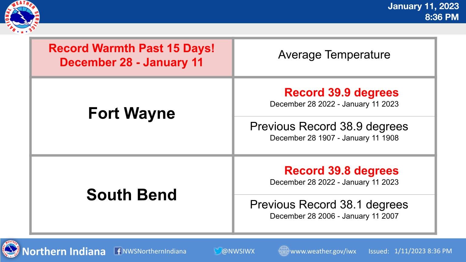
After such a fast start to the season in South Bend only 0.4" of snow has fallen in January. It's the 6th least snowiest start to the month on record. The season's total sits at 39.5" which is still about 8" above normal. Info courtesy WSBT-TV Storm Alert Weather Team.
-
 1
1
-
-
The lake effect machine could be running at full throttle late next week around here. Water temp at mid-lake of Lake Michigan is in the low 40's. It's the one positive of a warm January.
-
-
Thoughts and prayers for a lake effect response as the low pulls away. Global models are picking up on something.
-
Punting this one. The next one looks too far north at this time, too, but we’ll see. At least there are storms to track.
-
#TeamCanada
-
I thought the last 15 days seemed warmer than ever...
-
I gotta feeling about this one...or maybe the next one.
-
1
-
-
19 minutes ago, Hoosier said:
60s would be better. Might as well go all-out on warmth in times like these.

-
Euro and GFS all have a signal for a potential snowstorm somewhere in the Great Lakes area next Thursday. There's nothing else track-worthy so I'm all in on this one.
-
1
-
-
50 degrees and sunny. Can't beat it in January. Kooky Palm Tree guy might be onto something here.
-
The point is few, if any, meteorologists are going to start making predictions that it's going to snow without some kind of model consensus. Even here a thread was started once there was some consensus among the models.
-
Two days ago the GFS was also showing a decent ice storm across I-80 in Indiana and Illinois. Good thing mets didn't sound the alarm about that because it's long gone now. They waited to see if there would be model consensus. Shocking concept!
-
I'd give it a B+ here. We've really only had two events (a week of lake-effect in November and the Christmas lake-effect blizzard) but they were both great events here. We're 15" above average for snowfall for this time of year. I'd give it an "A" but it's been painfully boring and cloudy between the big events. At least the sun is out today.
-
That Euro run gives me like 6 inches on the 10:1 map. I expect ratios to be a little worse than that. We could thread the needle to about 4" here.
-
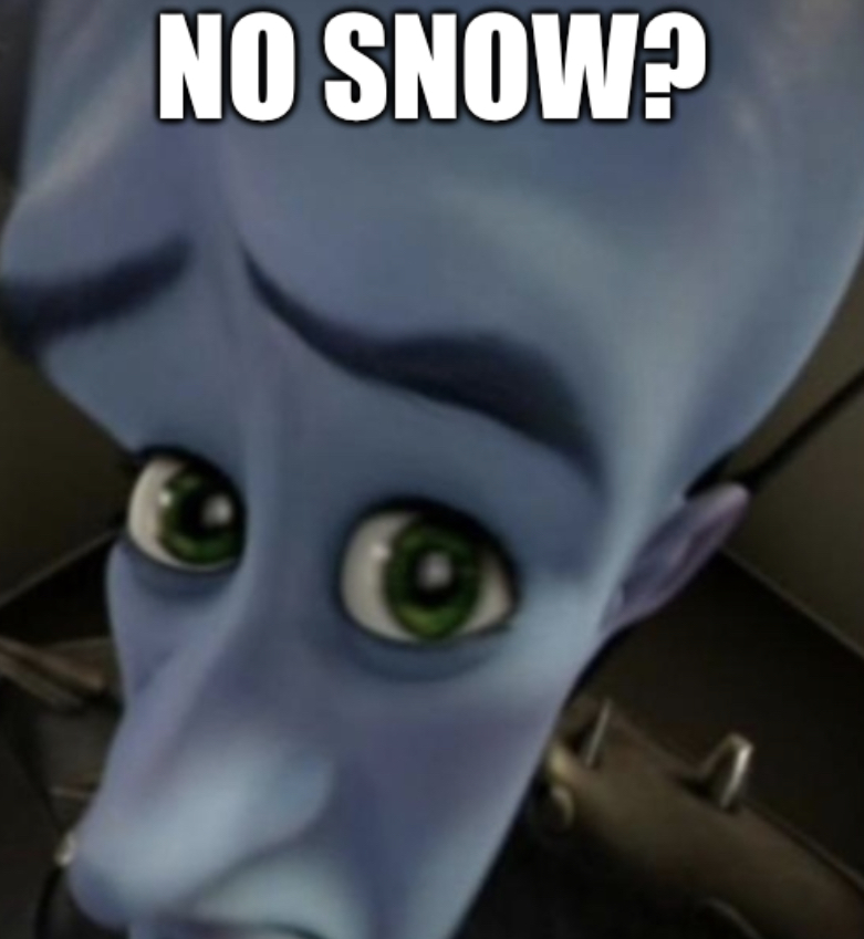
2 hours ago, Hoosier said:
No flakes for us?


-
1
-
Midwest/Ohio Valley/Great Lakes Snow January 24-26
in Lakes/Ohio Valley
Posted
4” seems like a solid bet. Good start to a snowpack. Keep ‘em coming.