

sbnwx85
-
Posts
1,445 -
Joined
-
Last visited
Content Type
Profiles
Blogs
Forums
American Weather
Media Demo
Store
Gallery
Posts posted by sbnwx85
-
-
Not sure if this was posted here or not because I’ve been looking at a lot of information sources, but some power companies in Southeast Michigan aren’t going to start restoring power until sunrise because it’s too dangerous to be out right now.
-
1 hour ago, Hoosier said:
Obviously
 but 18z GFS had an insane ice storm toward the end of the run. Some areas get freezing rain for like 36 hours. Catastrophic may not be a strong enough word.
Fun to look at though.
-
Had some pretty hard rain. Flash flooding possible tonight.
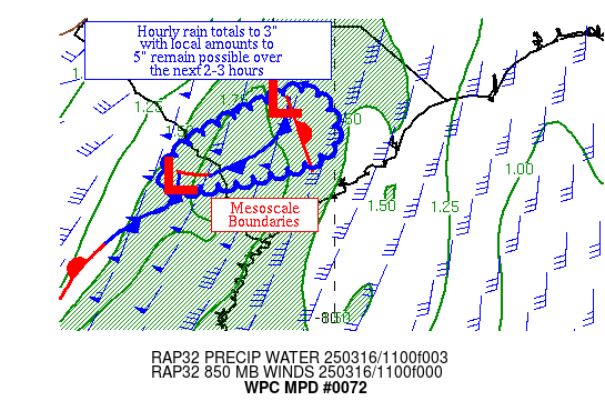
Mesoscale Precipitation Discussion 0072
NWS Weather Prediction Center College Park MD
433 PM EST Wed Feb 22 2023

Areas affected...central/northern IL into northern IN,
northwestern OH and southern MI

Concerning...Heavy rainfall...Flash flooding possible

Valid 222130Z - 230330Z

SUMMARY...Heavy rain will continue a threat for flooding from
central/northern IL into northern IN and extreme northwestern
OH/southern MI. Peak rainfall rates of just over 1 in/hr will
allow for an additional 1 to 2 inches of rain through 03Z, but
rainfall intensity is expected to decrease with time.

DISCUSSION...Regional radar imagery at 21Z showed a broad shield
of precipitation extending to the north and northeast of a surface
low analyzed over central IL. Localized reports of 1+ in/hr have
occurred across portions of central IL over the past few hours
where the SPC mesoanalysis indicated MUCAPE near 100 J/kg and
precipitable water values of 1.2 to 1.4 inches. MRMS and gauge
reports indicated 1 to 3 inches of rain has fallen over the past
12 hours from central IL into north-central IN. Across far
northern IN/OH into southern MI, surface temperatures near 32 have
supported areas of freezing rain with the freezing line expected
to only marginally lift north over the next few hours.

As a negatively tilted shortwave over the mid-Mississippi Valley
continues to advance northeastward, it is expected to maintain a
weakening trend and support the ENE track of the surface low over
central IL toward northwestern OH. South-southwesterly 850 mb
winds of 50 to 60 kt just ahead of the shortwave and surface low
are expected to continue strong ascent over a well-defined warm
front extending eastward from the low. Elevated instability is
only about 100-200 J/kg according to the 20Z SPC mesoanalysis but
is forecast to gradually lower over the next 3-6 hours which
should reduce peak rainfall intensity to 0.5 to 0.75 in/hr beyond
00Z.

An additional 1-2 inches of rain is expected through 03Z, with
rainfall ending from west to east. Expected rainfall should near
area 3-hr flash flood guidance of 1 to 1.5 inches, but should
primarily lie north of the axis of heavy rain that has fallen over
the past 12 hours. Nonetheless, localized areas of flooding will
be possible, within a fairly narrow corridor between the warm
front and frozen precipitation to the north over southern MI.

Otto
-
 1
1
-
 1
1
-
-
33 and rain has me posting fantasy Euro storms. Sad!
-
 2
2
-
-
^What could go wrong this far out?

-
1
-
-
9 minutes ago, WestMichigan said:
Models really want to wind something up the first week of March. Only 8 more days to go before it turns into a shell of its original self and someone gets 6" or less.
Just posted about that in the medium/long range thread. Trying to reel it in for us. It's probably our last hope before "spring".
-
I'm telling you right now...this is gonna be the big one for us.
GFS has a storm, too, but it'll come around and slide west soon.
-
Tornado Watch up for the southern half of Illinois and Eastern Missouri.
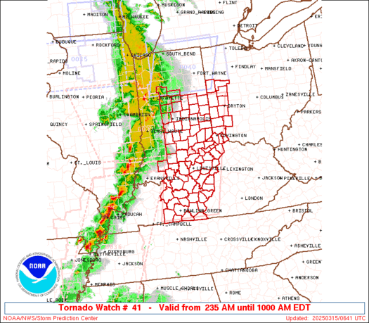
SUMMARY...A broken line of storms is expected to intensify and race
   northeastward and pose a damaging wind and tornado risk,
   particularly in vicinity of a warm front from near/north of the St
   Louis area into south-central Illinois.
-
3
-
-
On the way into work I noticed one area in particular near the Toll Road where ice was still in the trees. I'd bet some areas in Northern Indiana ended up with a tenth of an inch of ice. I think MBY was just under that amount.
-
33 and rain. The worst weather on the planet.
-
1
-
 1
1
-
-
Hanging on to 32 degrees. Moderate rain coming down. The ice is having a harder time accumulating but there’s a little more than a couple hours ago. Still nothing on the ground so roads, outside of bridges and overpasses, shouldn’t be bad.
-
1
-
-
My backyard thermometer just went from 30 to 31 at 7 am. I’ll assume it was about this temperature while the moderate to heavy freezing rain moved through last hour. The parking lots and grass were only wet but everything else was covered in ice. Trees, cars, fences, etc. It seemed to accrue somewhat efficiently just above the ground. You’ve been alerted, Michigan posters. Good luck.
-
1
-
-
Going to hope for a rumble of thunder tomorrow.
-
1
-
-
IWX goes WWA for Branch and HIllsdale. I suspect they'll expand that to cover a light glaze of ice further south and west overnight. It's annoying some TV mets that they're waiting...
-
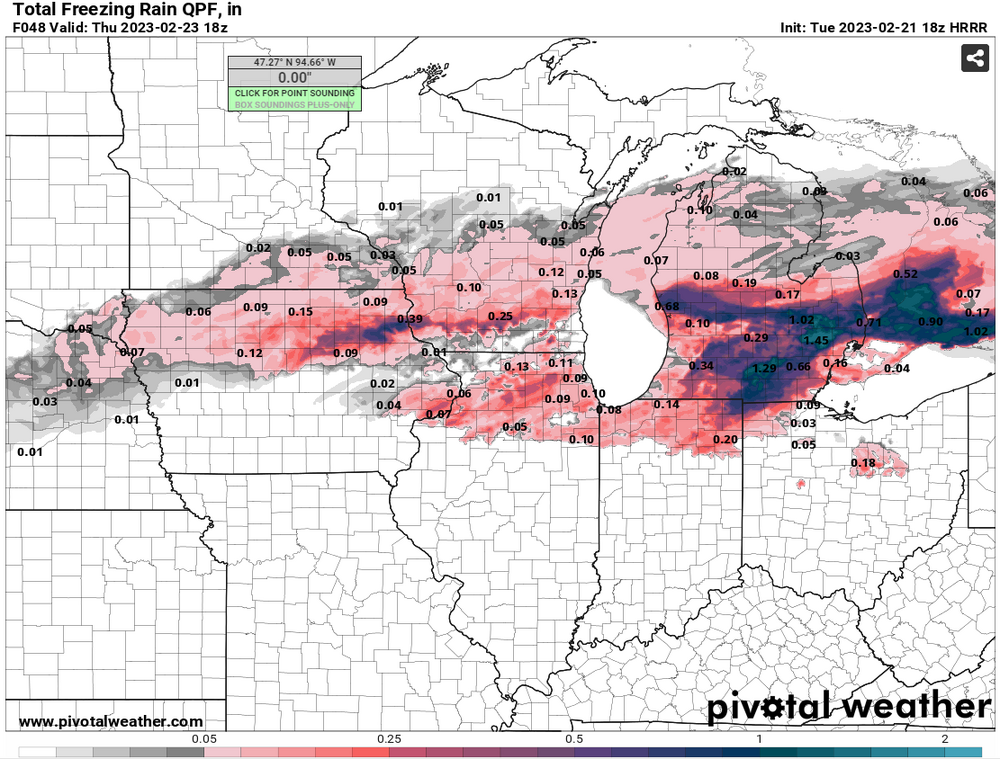
16 minutes ago, Hoosier said:
18z HRRR got some ice down into the I-80 corridor tomorrow morning.
There will be some dry air to play with early on (dews in the 20s) and precip onset seems to be speeding up, so I guess you never know.
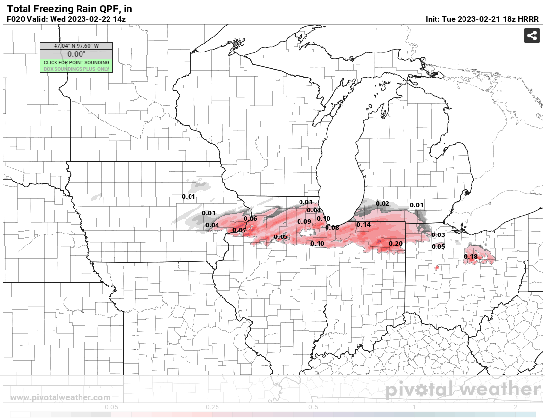
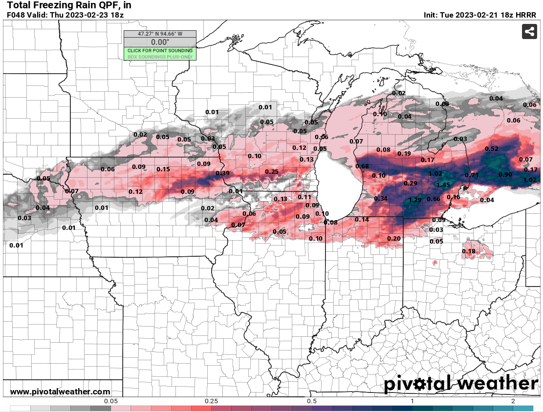
Look at what the HRRR puts down before temps go above freezing for my area.
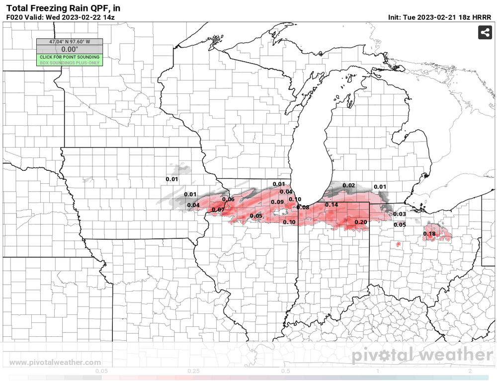
Edit: And here's the entire run...FWIW
-
1
-
 1
1
-
-
3 minutes ago, roardog said:
The euro says you’ll get into the 60s on Thursday for a minute. At least you have that possibly.

-
Just now, mimillman said:
36 degrees and 1-2” of rain is just about as miserable as it can get eh
I'll see your 36 degrees and raise you 34 degrees and rain.
-
1
-
-
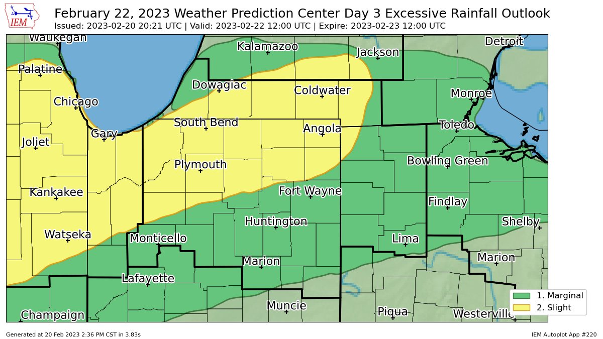
Pretty early in the year to break out the Excessive Rainfall Outlook map but here we are.
-
I always jump the gun in the "When Will Watches Be Issued Game". I may never learn.
-
I would imagine GRR would hoist watches this afternoon considering every model gives them heavy wintry precip in some form. IWX may issue one for Branch and Hillsdale in MI, too.
-
Just now, Hoosier said:
Seriously think I might nab a personal record for amount of rain with temps in the mid 30s.
The winter of futility records continues for ya. Smdh. At least the end of the month looks to be active.
-
Final call: cold rain. Going to be a doozy of an ice storm just about a county or two north though. Might be close enough to look around before work Thursday morning.
-
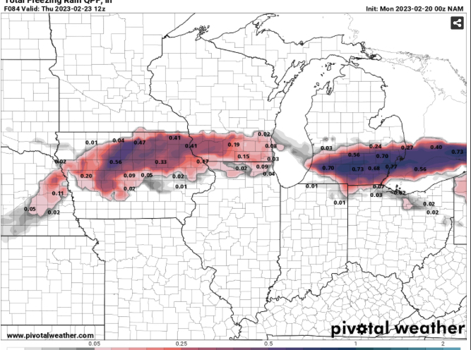
I thought NAM would be a bit south too at first but it turned out to be about the same as the previous run with placement of ice in Michigan. Still lofty totals too.
-
1
-
-
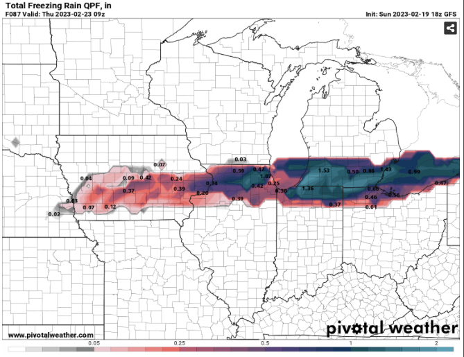
18z GFS says maybe it’s time for me to invest in a generator.


February 2023 General Discussion
in Lakes/Ohio Valley
Posted
If we can avoid any snow accumulation the rest of the month, which seems likely, this will go down as the 2nd least snowy February on record in South Bend. We've had 0.3" of snow so far. The record is a Trace in 1998.