

sbnwx85
-
Posts
1,445 -
Joined
-
Last visited
Content Type
Profiles
Blogs
Forums
American Weather
Media Demo
Store
Gallery
Posts posted by sbnwx85
-
-
I’m leaning toward a cold rain here but occasionally a GFS or Euro run gets ice south of the Michigan border…it’s enough to keep me invested. A shift south by 30-50 miles would put me in the worst of the freezing rain. For now, I-94 in Michigan looks like it will get hit the hardest with ice.
-
GFS is a touch south at 12z. Canadian a touch north. Some relatively minor run-to-run variability but overall each model has been really consistent since Friday.
-
I’d imagine it would be tough to get much ice along the Illinois/Wisconsin side of the lakeshore with water temps in the mid-30’s and an east wind. Otherwise, it looks like a nasty storm where ever that corridor sets up.
-
 1
1
-
-
00z GFS pretty much the same as 12z. 00z Canadian came far enough south to bring significant icing to Northern Indiana/Illinois. Going to be fun to track this one.
-
That crap can stay north thank you very much.
-
1
-
-
Never got more than a DAB of snow. On to the next one...and 60 degrees next week?
-
Light glaze followed by a DAB of snow. Hoping we can reach an inch of snow before the event ends.
-
5 minutes ago, Hoosier said:
Good general model agreement on a winter storm with significant snow and ice potential next week.
Yeah, I noticed that too. I won't get too hung up on placement yet but if this one ends up being a miss that will be a major disappointment. Either way, I'll be welcoming Spring after next week.
-
37 and rain. Yuck.
-
Final call: Cold rain, freezing drizzle, dab of sleet, inch of snow.

-
 1
1
-
-
Maybe it's the NAM being the NAM at this range but even SBN gets in on some wintry precip and snow.
-
I know @Hoosierwas just teasing but certainly not looking for any sympathy. I know I'm lucky to have gotten the snow I've had this winter. The near-record November snow and pre-Christmas blizzard were all lake-effect. Without the lake I'd agree with the ~9" total.
-
I didn't think it would be possible two months ago, but we are now below average on snowfall for the season. What an odd winter...terrible for many snow-lovers.
-
52 and full sun. Absolutely gorgeous weather in February. Wind hasn’t kicked in yet. I might plant a palm tree today.
-
Good call, @Hoosier IWX just issued a rare High Wind Watch.
URGENT - WEATHER MESSAGE
National Weather Service Northern Indiana
230 PM EST Tue Feb 7 2023

INZ005>009-012>015-017-018-020-022>027-032>034-103-104-116-203-
204-216-MIZ078>081-177-277-OHZ001-002-004-005-015-016-024-025-
080330-
/O.NEW.KIWX.HW.A.0001.230209T1200Z-230210T0000Z/
Elkhart-Lagrange-Steuben-Noble-De Kalb-Starke-Pulaski-Marshall-
Fulton IN-Whitley-Allen IN-White-Cass IN-Miami-Wabash-Huntington-
Wells-Adams-Grant-Blackford-Jay-Northern La Porte-
Eastern St. Joseph IN-Northern Kosciusko-Southern La Porte-
Western St. Joseph IN-Southern Kosciusko-Cass MI-St. Joseph MI-
Branch-Hillsdale-Northern Berrien-Southern Berrien-Williams-
Fulton OH-Defiance-Henry-Paulding-Putnam-Van Wert-Allen OH-
Including the cities of Elkhart, Goshen, Nappanee, Lagrange,
Topeka, Shipshewana, Angola, Fremont, Kendallville, Ligonier,
Albion, Auburn, Garrett, Knox, North Judson, Bass Lake, Winamac,
Francesville, Medaryville, Plymouth, Bremen, Culver, Rochester,
Akron, Columbia City, Tri-Lakes, South Whitley, Fort Wayne,
New Haven, Monticello, Monon, Brookston, Logansport,
Royal Center, Peru, Grissom AFB, Mexico, Wabash,
North Manchester, Huntington, Roanoke, Bluffton, Ossian, Decatur,
Berne, Marion, Gas City, Upland, Hartford City, Montpelier,
Portland, Dunkirk, Michigan City, La Porte, Kingsbury, Fish Lake,
South Bend, Mishawaka, Lakeville, Granger, Syracuse, Milford,
North Webster, Leesburg, Wanatah, La Crosse, Union Mills,
North Liberty, New Carlisle, Walkerton, Warsaw, Winona Lake,
Silver Lake, Mentone, Dowagiac, Cassopolis, Edwardsburg,
Marcellus, Sturgis, Three Rivers, White Pigeon, Mendon,
Coldwater, Bronson, Hillsdale, Jonesville, Litchfield,
Benton Harbor, St. Joseph, Paw Paw Lake, Niles, New Buffalo,
Stevensville, Berrien Springs, Bryan, Edgerton, Wauseon,
Archbold, Swanton, Delta, Defiance, Sherwood, Hicksville,
Napoleon, Deshler, Liberty Center, Paulding, Antwerp, Payne,
Ottawa, Leipsic, Columbus Grove, Continental, Pandora, Van Wert,
Ohio City, Lima, and Spencerville
230 PM EST Tue Feb 7 2023 /130 PM CST Tue Feb 7 2023/

...HIGH WIND WATCH IN EFFECT FROM THURSDAY MORNING THROUGH
THURSDAY EVENING...

* WHAT...Southwest winds 25 to 35 mph with frequent gusts of 45 to
  55 mph. Isolated gusts up to 60 mph possible.

* WHERE...Portions of northern Indiana, southwest Michigan and
  northwest Ohio.

* WHEN...From Thursday morning through early Thursday evening.

* IMPACTS...Damaging winds could blow down trees and power lines.
  Power outages are possible. Travel could be difficult,
  especially for high profile vehicles.
-
We'll see...
-
If it comes with the same severe weather outbreak, I'll allow it.
-
2
-
-
I was working in Central IL at the time. It was a solid storm with 10" of snow in Jacksonville/Springfield, but I was jealous of the wind and monster totals my family was getting back home in Indiana. I think a Blizzard Warning went into effect for a while for IWX.
-
59 minutes ago, Cary67 said:
Interesting graphic showing how lame even last winter was for a large portion of the subforum even compared to this year up to this point. Last Feb. southern half of LOT to DTW cashed in to offset those deficits.
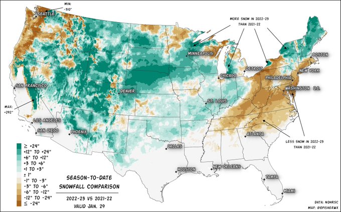
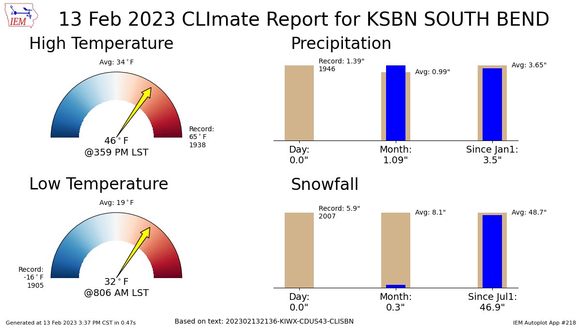
That week in November really padded the stats in South Bend. 30.2" in November, 8.9" in December, and 7.5" in January. 46.6" on the season...Last year at this time we had 24.8".
-
Mood flakes currently. I’ll take it.
-
1 hour ago, Hoosier said:
Was curious so I checked. Here's a fun fact. ORD snowfall through 1/28
2011-12: 13.7"
2022-23: 13.6"
If it means another heat wave like March 2012 I’m all for it…minus the subsequent drought that summer.
-
2
-
-
Just a light glaze of ice here.
-
Sun just came out which is nice.
-
16 minutes ago, Hoosier said:
Definitely think LOT will expand the advisory southward with the afternoon package to account for icing.
Temps could be around 28-30 in part of the icing area. The warm layer aloft is not obnoxiously warm (no 10C or something like that) so raindrop temperatures won't be extremely warm. This combined with rates that should be mostly light would suggest not much, if any qpf being "wasted"
Would think IWX would issue one too for the far northwest counties. Get the word out now about the freezing rain threat. I’ve seen what happens when salt isn’t out down on roads before just a tenth of an inch of glaze adds up…it ain’t pretty.
February 21-23 Major Winter Storm
in Lakes/Ohio Valley
Posted
That is a blessing. I’ve been in an ice storm in January 2001 where half of an inch of ice accrued and temps stayed below freezing for over a week. Took several days to restore power.