

sbnwx85
-
Posts
1,445 -
Joined
-
Last visited
Content Type
Profiles
Blogs
Forums
American Weather
Media Demo
Store
Gallery
Posts posted by sbnwx85
-
-
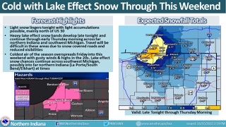
Lake effect behind next week's system has some potential.
-
 1
1
-
-
The Euro is trying to bang out a couple inches of snow around here on Friday.
")
-
1
-
-
Half an inch of rain coming here.
-
South Bend is currently in its 35th snowiest month ever at 30.2 inches. It's the 2nd snowiest November on record. The snowiest November was in 1977 when 30.3 inches fell.
Here's how much more snow we received after the top 5 snowiest November's on record in South Bend (I'm not counting March because that's Spring). Normal for those months (November-February) is 56.5 inches:
1977
November - 30.3"
December - 33.6"
January - 86.1"*
February - 16.6"Total - 166.6"
*Snowiest month on record in South Bend.
1951
November - 23.4"
December - 30.7"
January - 12.7"
February - 2.4"Total - 69.2"
1976
November - 21.6"
December - 37.6"
January - 37.2"
February - 13.9"Total - 110.3"
1911
November - 20.5"
December - 12.5"
January - 14.0"
February - 12.5"Total - 59.5" (Lots of missing data)
2014
November - 19.1"
December - 0.2"
January - 22.1"
February - 36.2"Total - 77.6"
-
This band in South Bend is absolutely dumping. It’s been just barely to my south the last four hours but coming north. Unofficial reports on Twitter indicate 2”-4” per hour.
-
Downtown South Bend under a death band right now.
https://wsbt.com/weather/storm-alert-weather-cameras/south-bend-04-29-2016
-
Quality rippage.
-
2
-
-
Snow squall at the ND football game.
-
IWX upgraded three of its Michigan counties to a WSW. The winds are gonna be a problem.
...WINTER STORM WARNING IN EFFECT UNTIL 7 AM EST SUNDAY...

* WHAT...Heavy lake effect snow and areas of blowing snow
  expected. Total snow accumulations of 4 to 7 inches. Near zero
  visibilities in heavier snow showers. Winds gusting as high as
  40 mph. Wind chills dropping into single digits tonight.

* WHERE...Cass MI, St. Joseph MI, and Berrien Counties.

* WHEN...This afternoon into tonight.

* IMPACTS...Plan on slippery, snow covered roads. Areas of blowing
  snow and heavy snow will significantly reduce visibility.
-
We’ve had a nice winter this week in South Bend. Credit for this tidbit from WSBT-TV meteorologist Bob Werner:
20.6" of snow we've had this week (11/12-18) is by far the most we've ever gotten during that time of the year! Previous most was 16.8" during 11/12-18/2014.
For further perspective, 20.6" is more than the normal snowfall for all of December (13.7") or February (16.1").
-
2
-
-
8” on the ground here. Probably 5” of it fell last night and today. Pretty good considering I was expecting only an inch of fresh snow.
-
1
-
-
It’s a far cry from Buffalo but prime lake effect conditions for Northern Indiana.
-
2
-
-
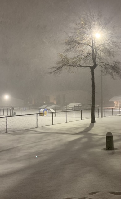
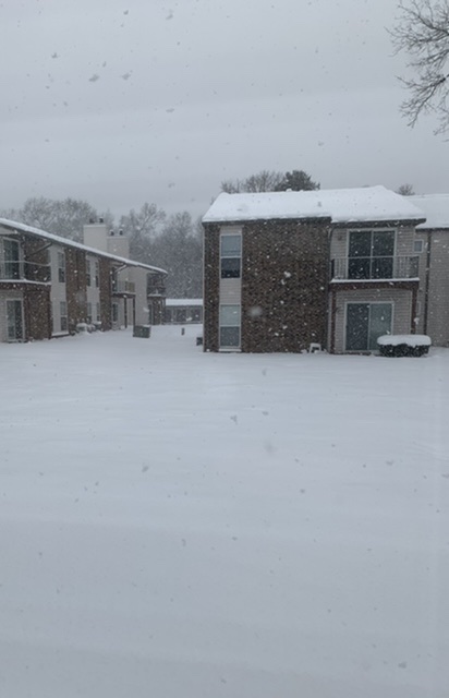
Was a bit surprised to see how far south the lake effect bands drifted into Indiana this morning. It was snowing at a pretty good clip when I let the dogs out. I forgot my tape measure, but I’d eyeball about 6 on the ground right now…about 3 of that is fresh snow from overnight/this morning.
-
The arctic front on Saturday kind of snuck up on me. 3k NAM gets me 5 inches of snow between the front and lake effect shifting the winds a little more NW. Notre Dame has a 2:30 kickoff. Would be fun to make it a snow game.
-
I got 4 inches of snow from yesterday’s and last night’s lake effect event. The big winners were about a half hour north of me where 13 inches fell. I also saw a report of 8 inches about 45 minutes south of me.
Currently seeing flurries. The lake should help boost the squalls going through Chicagoland. Thinking I could get another inch tonight before all the lake snows stay north of the border.
-
Had lake effect snow falling since mid-afternoon but it didn’t start sticking until about 4:30 EST.
-
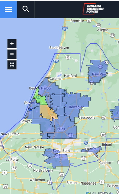
The lake effect band has largely stayed to my north all morning. Just a coating here. The heavy, wet nature of the snow is causing power outages already in parts of Michigan. 5,400 Indiana Michigan Power customers are out.
-
Actually ended with a DAB.
-
Finally started seeing flurries when I went outside about 20 minutes ago.
-
 1
1
-
-
The 7 inches of snow I picked up Saturday night is nearly all gone. There are a lot more green patches that white on the ground. Time to replenish.
-
1
-
-
I haven’t been out much today but haven’t seen anything fall from the sky or any accumulation. Might be a virga storm here. Awaiting the lake effect tomorrow.
-
Good luck and enjoy! Will be watching from the Lake Michigan snow belt in South Bend.
-
2
-
-
The sun is out here.

-
https://www.weather.gov/iwx/20020130_ice
The ice storm of 2002 in Northern Indiana was unforgettable. It was January 30th. A couple inches of snow fell followed by over a half inch of ice accumulation. I’ll never forget how beautiful and icy everything looked. But it was dangerous to be outside because every 30 to 60 seconds you would hear a huge tree limb snap and crash to the ground. I will always remember watching one of the limbs narrowly miss a sports car parked across the street. Power was knocked out to 100,000 people. It was also very cold after the storm making it difficult to restore power. In fact, we didn’t get power back for 5 days. My mom, extended family and myself huddled into my grandma’s living room where she had a natural gas fire place. For a 15-year-old it was fun to spend time with family, playing games and eating fast food.My favorite thunderstorm would have to be June 23rd, 2010. https://www.weather.gov/iwx/20100623_lewp
It was the crescendo to a very active week of severe weather. A derecho earlier in the week didn’t produce much damage in Elkhart, but this one did plenty. Watching the shelf cloud approaching and the feeling the gust front drop temps about 15 or 20 degrees in just a few seconds was wild. The winds were the fiercest I’ve ever experienced between 80 and 90 mph. You could hear the trees going down all around.
1/2/99 is probably third on my list but I have mixed emotions about that day. It was incredible seeing 20+ inches of snow on the ground but I ended up with the worst stomach virus I’ve ever had that day.
There was also the funnel cloud that developed DIRECTLY OVERHEAD at my grandma’s house on July 20, 2003. There was never a Tornado Warning and it never touched down, but it was an incredible sight. The RFD did some damage taking down a few trees nearby.
I’d be remised if I didn’t mention the historic flooding I covered as a radio reporter in Jacksonville, IL on June 18, 2011. 6 to 12 inches of rain fell the night before causing horrible flooding of the Town Brook. I remember watching a van float away and police rescue people in a mobile home park as the waters kept rising. The water treatment plant flooded causing the city to go under a boil order for two weeks.
-
3
-
Dec 8-9th Snow Event
in Lakes/Ohio Valley
Posted
Had a wave of fat flakes for several minutes. No accumulation. Waiting for the rest of the precip shield to move in. Might start off with some snow before switching to rain.