

Eskimo Joe
-
Posts
24,545 -
Joined
-
Last visited
Content Type
Profiles
Blogs
Forums
American Weather
Media Demo
Store
Gallery
Everything posted by Eskimo Joe
-

2020 Mid-Atlantic Severe Weather - General Thread
Eskimo Joe replied to Kmlwx's topic in Mid Atlantic
Today has the feeling of something rogue dropping into our area on NW flow that turns into a big day for someone. -
Nice picture. It's almost criminal to not be throwing a frog in that water. Looks like some prime bass fishing.
-
Next storm smells fishy, especially if it winds itself up up too fast.
-
2020 Mid-Atlantic Severe Weather - General Thread
Eskimo Joe replied to Kmlwx's topic in Mid Atlantic
Looks like west of I-270 is the place to be today. -
2020 Mid-Atlantic Severe Weather - General Thread
Eskimo Joe replied to Kmlwx's topic in Mid Atlantic
80% chance of a T'storm watch shortly: https://www.spc.noaa.gov/products/md/2020/md1570.html -
2020 Mid-Atlantic Severe Weather - General Thread
Eskimo Joe replied to Kmlwx's topic in Mid Atlantic
Eh, it's okay. Mappy get a couple of 55dbz pixels over her. The rest is pretty typical summer storms. Nothing that would warrant an ENH. In fact, the 15z HRRR is mostly dry for the DY1 ENH area. The best activity is west of Westminster. -
2020 Mid-Atlantic Severe Weather - General Thread
Eskimo Joe replied to Kmlwx's topic in Mid Atlantic
They would certainly produce some rain for everyone's yards. It seems the HRRR has handled the morning batch of convection the "best". We are going to have to see what things look like around 5:00 pm or so. The action doesn't really appear to develop until it sinks south of the PA Turnpike. The latest HRRR, for example, has the line coming through the DC area around 23z to 01z. Not the greatest timing, but NW flow events usually jackpot someone. -
2020 Mid-Atlantic Severe Weather - General Thread
Eskimo Joe replied to Kmlwx's topic in Mid Atlantic
Latest HRRR would at least water everyone's grass. -
Not sure if this was already posted, but this thread is worth reading:
-
I miss the days of getting a 8" - 12" storm, then a clipper a few days later that adds a nice 2" - 4" of fluff on top of everything. Clipper snows always have that nice little sweet spot surprise.
-
Everything correlates to a warm [insert winter month here] anymore in these parts.
-
2020 Mid-Atlantic Severe Weather - General Thread
Eskimo Joe replied to Kmlwx's topic in Mid Atlantic
Glad to see you back Joey! -
IMO, 93L needs to be at least a PTC. Several ASCAT passes show it's healthy, has a tightening circulation and isn't getting disrupted by anything (shear, etc.).
-
2020 Mid-Atlantic Severe Weather - General Thread
Eskimo Joe replied to Kmlwx's topic in Mid Atlantic
We have a lot of DCAPE. Going to be some good wind reports today and some interesting multicell clusters. -
2020 Mid-Atlantic Severe Weather - General Thread
Eskimo Joe replied to Kmlwx's topic in Mid Atlantic
80% on the meso: https://www.spc.noaa.gov/products/md/2020/md1310.html -
2020 Mid-Atlantic Severe Weather - General Thread
Eskimo Joe replied to Kmlwx's topic in Mid Atlantic
Yup, beefy SBCAPe/DCAPE = localized woo storms. -
2020 Mid-Atlantic Severe Weather - General Thread
Eskimo Joe replied to Kmlwx's topic in Mid Atlantic
Truly a hit-or-miss day. With SBCAPE well over 4,000 j/kg regionally the risk for numerous wet microbursts existed so the watch box is more than justified. Amazing how it's so varied across the area. In Reisterstown, we've got about 4 or 5 storms bubbling up around us but nada falling from the sky. -
2020 Mid-Atlantic Severe Weather - General Thread
Eskimo Joe replied to Kmlwx's topic in Mid Atlantic
Man it would be sick if something triggered right around sunset. Get a nice overnight light show. -
2020 Mid-Atlantic Severe Weather - General Thread
Eskimo Joe replied to Kmlwx's topic in Mid Atlantic
Grew up in Philly. Big urban watersheds that flash quickly and have killed folks swimming in the creeks or fishing. The spike on discharge in Frankford Creek right now is something you only see during tropical storms.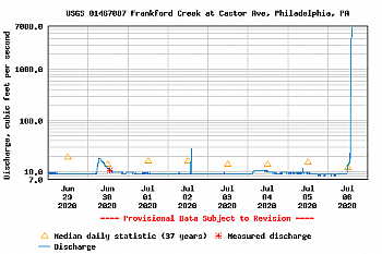
-
2020 Mid-Atlantic Severe Weather - General Thread
Eskimo Joe replied to Kmlwx's topic in Mid Atlantic
SPC issues Severe Thunderstorm Watch until 03:00 UTC Tues, 7/7 -
2020 Mid-Atlantic Severe Weather - General Thread
Eskimo Joe replied to Kmlwx's topic in Mid Atlantic
Radar estimates crossing 3" now. -
2020 Mid-Atlantic Severe Weather - General Thread
Eskimo Joe replied to Kmlwx's topic in Mid Atlantic
12z IAD RAOB has a ConvT of 91°. Philly hit 91° and things went boom. -
2020 Mid-Atlantic Severe Weather - General Thread
Eskimo Joe replied to Kmlwx's topic in Mid Atlantic
FFW expanded to include Fairfax. -
2020 Mid-Atlantic Severe Weather - General Thread
Eskimo Joe replied to Kmlwx's topic in Mid Atlantic
Accounts for meso boundaries. While definitely a true lower end slight for today, beefy SBCAPE and DCAPE means someone is gonna get rocked. -
2020 Mid-Atlantic Severe Weather - General Thread
Eskimo Joe replied to Kmlwx's topic in Mid Atlantic
80% of a WW: https://www.spc.noaa.gov/products/md/2020/md1116.html


