so_whats_happening
-
Posts
1,577 -
Joined
-
Last visited
Content Type
Profiles
Blogs
Forums
American Weather
Media Demo
Store
Gallery
Everything posted by so_whats_happening
-
El Nino 2023-2024
so_whats_happening replied to George001's topic in Weather Forecasting and Discussion
Yea 21/22 (i believe this was more se this year than s, jersey shore delaware folks) was also another year where they got hit quite a bit. Rough being nearly 60 miles straight shot and getting half the snowfall. -
El Nino 2023-2024
so_whats_happening replied to George001's topic in Weather Forecasting and Discussion
I was referencing lancaster area we had 13" that year. -
El Nino 2023-2024
so_whats_happening replied to George001's topic in Weather Forecasting and Discussion
If we did the same thing and used years where from ASO to peak (typically peak was OND averaged out) was less than .5 increase for all strong/super ninos we get a slightly different look. Lets see what happens coming up here as far as increases go in the next two months since there is a lag, a later peak may be more beneficial than we think. -
El Nino 2023-2024
so_whats_happening replied to George001's topic in Weather Forecasting and Discussion
Anyway back to ENSO with October probably coming in around 1.6 for the monthly we should have an ASO reading of around 1.5. Now looking back at all the El Nino years from this point on to their peak where we saw large increases in 3.4: 1957-58: saw .5 increase from ASO reading to DJF peak (1.8) 1972-73: saw .5 increase from ASO to OND/DJF peak (2.1) 1982-83: saw a .6 increase from ASO to OND/DJF/JFM peak (2.2) 1987-88: saw a .5 increase from ASO to NDJ/DJF peak (1.2) 1991-92: saw a 1.1 increase from ASO to DJF peak (1.7) 1994-95: saw .5 increase from ASO to NDJ peak (1.1) 2009-10: saw .9 increase from ASO to NDJ peak (1.6) All other years had below .5 increase from ASO to their respective peak values most falling in the .3 increase between the two timeframes. Using only the strong and super years since we are relatively close to both in this current setting. All had a warm December, again not big surprise (not super warm but warm). January was cold south warm north, active track across the country. February turned rather cold for most in the east and offered a fantastic storm track setup. Now this is basing off the idea of strong/ super Ninos that experienced increased warming past their ASO numbers greater or equal to .5 increase. -
El Nino 2023-2024
so_whats_happening replied to George001's topic in Weather Forecasting and Discussion
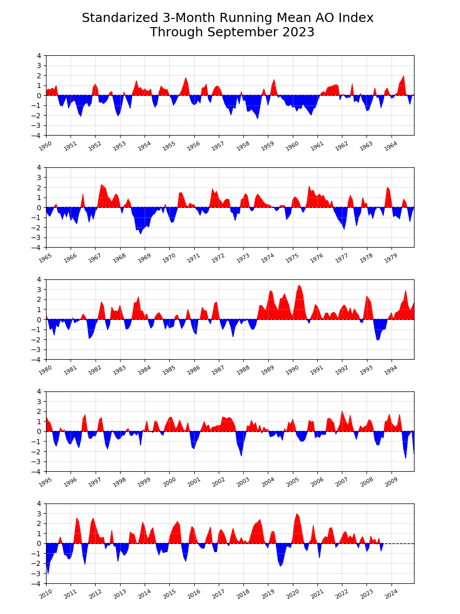
Yea weird stuff ignoring ENSO state looking at 1953-54 +AO/NAO led to a warm winter while 1957-58 was -AO/NAO period led to really cold conditions in the east, something we would typically expect. 1953/54 had average snows while 1957/58 had close to double the season snowfall. Missed western ridging during both those years, when it did show up it was rather mundane. While checking out 13-14 and 14-15 both had extensive west coast/BC ridging even with -NAO/AO in 13-14 and +NAO/AO in 14-15 both winters probably the coldest we have seen in quite some time. 2013/14 had double the snow across the area while 2014/15 had a normal seasonal total. This was definitely a weird time opposite of what we would typically expect snowfall wise. 2009/10 had some deep -NAO/AO times but very little in the way of west coast ridging except for some around Alaska. This was our snowiest winter recorded. I feel we had a discussion about this not too long ago. -NAO helps funnel cold, doesn't create it just allows it to have more impact in the east, if the cold is there, -NAO also slows storm track if we can get the typical 50/50 to develop too (we didn't see that last winter). Western ridging knocks the cold into the US this can be seemingly changed up by a very positive EPO as shown in 1957/58 creating a pseudo ridge warming pattern in the BC region even without an actual full ridge pattern. In all of this we can just see snowfall is wayyy too variable of a thing versus saying the winter can be colder or warmer based off these years. As for precip anomalies that probably more so depends on the ENSO/PDO state at hand. Edit: gotta fix my 13/14 and 14/15 mistake. -NAO/AO produces big for our area if they both are working in tandem. +AO/+NAO is a lot more variable. -AO is the key more than -NAO for a cold winter while -NAO allows better snow potential given a -AO. -
El Nino 2023-2024
so_whats_happening replied to George001's topic in Weather Forecasting and Discussion
We could honestly sit there and say that about a lot of things in weather. There are things though that do allow forecasters the ability to foresee some of these events. So while actual values (severity) will differ one can see a pattern leading up to -AO/-NAO regime or +AO/+NAO regime just like we can see in advance poleward fluxes that may induce sudden stratospheric warming episodes. It isn't perfect but it can clue folks in on what may be to come given these circumstances evolving. Just like we have had nearly 150 page discussion on ENSO state. I believe many years ago it was postulated that a warmer Arctic would more often than not induce a -AO regime definitely has not been the case though. We seem to have periods where +AO is more likely (string of rather +AO years) than -AO but to determine much outside of that would be rather tough. I do wish folks would use parameters as guidance and not certainties just like I hope one day people use guidance (computer models) as well guidance, but here nor there.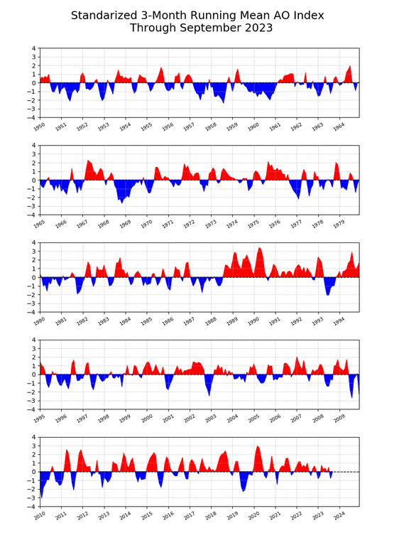
-
El Nino 2023-2024
so_whats_happening replied to George001's topic in Weather Forecasting and Discussion
Personally hope the troposphere remains detached from the SPV like we have seen off and on over the years. When it connects on either end it really connects so fingers crossed we don't develop a +AO this year early on. -
El Nino 2023-2024
so_whats_happening replied to George001's topic in Weather Forecasting and Discussion
I honestly hope I have the bolded correct it really has been like 5 or so years since I really dove into it. I should also mention it more so is a concentration of O3 increases with a disturbed PV versus a stronger PV which spreads out O3. -
El Nino 2023-2024
so_whats_happening replied to George001's topic in Weather Forecasting and Discussion
Im honestly unsure what the effects could be as well as many others are unsure. We clearly have not had something this profound in our recorded history, so to say with certainty one thing will happen over another is a bit much. One thing that needs to be noted is water vapor helps destroy O3 in the stratosphere (may be a reason as to why the southern hemisphere ozone hole grew again?). It has been awhile since I did any type of diving into the stratosphere and SSW but if I remember correctly there is more O3 present during a more disturbed PV with less during a stronger PV. So one could argue since the destruction of O3 is occurring due to a large increase in WV in the stratosphere it would allow for a stronger PV. This was a neat read though. In it a large increase in water vapor was noted to have a more northward jet signifying the potential of a stronger PV due to this. https://www.sciencedirect.com/science/article/pii/S1631071318301184 It should also be noted that -QBO years tend to allow Rossby waves to transfer poleward more easily causing disruptions to the PV over time. So it seemingly sounds like a mix bag situation right now. Blocking highs may counter balance the negatives of increased water vapor allowing more concentrated heat fluxes to the poles this year but we are still early and discussion of this outside of December onward is guessing at best. I would wait until close to the new year to see what may come about. -
El Nino 2023-2024
so_whats_happening replied to George001's topic in Weather Forecasting and Discussion
Throw in a little bit of 2015 Pacific pattern as well with the dual weak lows very similarly placed and ridging NW of Hawaii, ridging along the west coast. Big difference in the NAO domain though, I believe during that time were in the descending phase of solar which does promote a more +NAO regime if I remember folks in here pointing out. Again never perfect but interesting to say the least. -
DCA: -.5 NYC: 0 BOS: 0 ORD: +.2 ATL: +.4 IAH: +.6 DEN: +1.2 PHX: +1.7 SEA: +.8
-
El Nino 2023-2024
so_whats_happening replied to George001's topic in Weather Forecasting and Discussion
I mean there is a point to be made that there is some similarity to 97 atmospherically right now. Biggest difference that stands out is the higher heights on the west coast/ BC region which were the exact opposite in 1997. That will certainly be something to continue to watch as we move forward. Maybe a weaker Aleutian version of 1997 would make for an interesting year. There are some other flavors of Super Nino mixed in there from past events. Edit: had to go and emphasize some because a few may misconstrue the idea. -
El Nino 2023-2024
so_whats_happening replied to George001's topic in Weather Forecasting and Discussion
This seems to be an ongoing theme of late the troposphere kinda doing it's own thing from time to time and the Strat trying to couple but failing do so more often then not. -
El Nino 2023-2024
so_whats_happening replied to George001's topic in Weather Forecasting and Discussion
Did from mid month to the most recent plot. Looks like we finally are getting a more pronounced cooling look in the WPAC. We are shifting the anomalies located around the dateline eastward and having less of a cool pool under 3.4. Still nothing major to speak of as of yet but this does help explain the slight uptick in Upper ocean anomalies @GaWx had posted about the other day. I do not believe we will go over the last two peaks we saw but this will allow for warmer waters to spread out a bit more again giving that probable push close to 2C through November for 3.4. Still not seeing it go much above that as we move forward and I think we would need an East propagating WWB event to occur in time if something can manifest itself to push north of that 2C mark. -
El Nino 2023-2024
so_whats_happening replied to George001's topic in Weather Forecasting and Discussion
Fairly good, it is not recommended to go past hr 240 though. -
El Nino 2023-2024
so_whats_happening replied to George001's topic in Weather Forecasting and Discussion
Because that shows anomalies not an index so yes they are different. -
El Nino 2023-2024
so_whats_happening replied to George001's topic in Weather Forecasting and Discussion
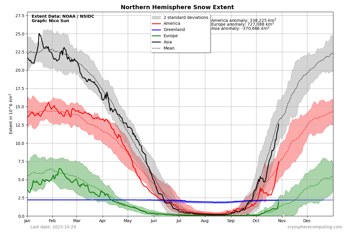
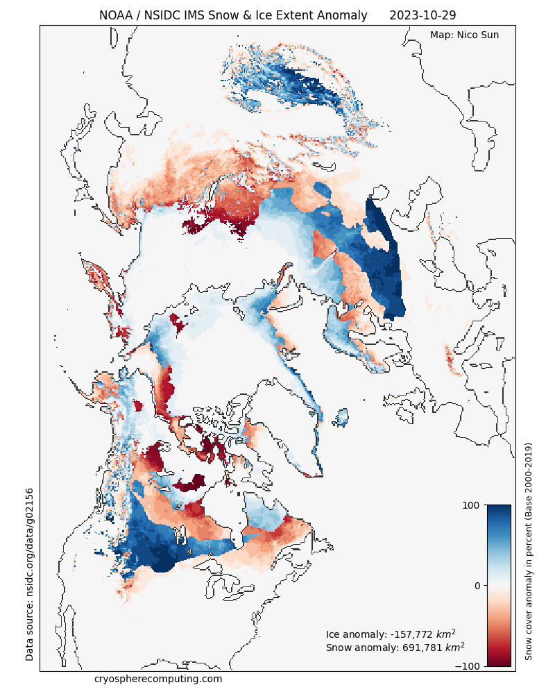
Im not sure what constitutes a good snowfall cover season over another but we have seen buildup decent since the beginning of October to be just below average currently. As for sea ice the Pacific side and CAA is suffering a little but the Atlantic front is surprisingly strong right now. https://cryospherecomputing.com/ Edit: you can see where the ridging has been most of the summer which seems to be where some of the anomalous ice deficit has shown up with the re-freeze.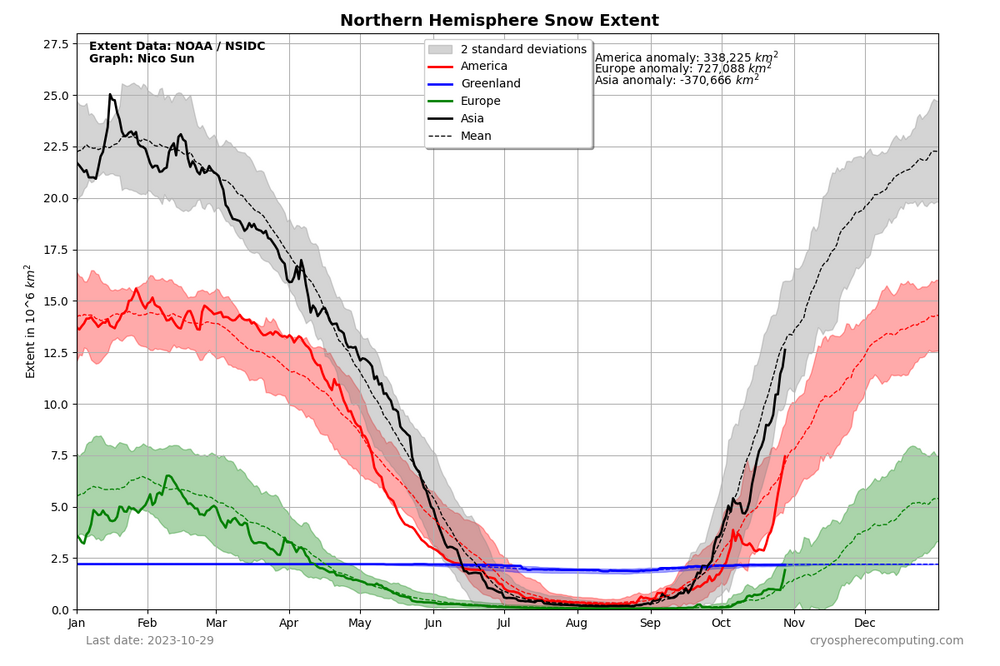

-
El Nino 2023-2024
so_whats_happening replied to George001's topic in Weather Forecasting and Discussion
Here was the U total at 850 during the long late January to end of February WWB event. This also created one of these largest amplitudes of region we have seen in a very long time. The resulting subsurface and I stopped it just before the secondary smaller event took place in April. This should be able to support a +2C reading at some point (maybe mid November to mid December?) That would yield a potential trimonthly max around 1.7-1.8 when all is said and done the question comes what happens after this. Im just not sure though the longevity of such an event my guess is a month at best unless we see continual WWB activity show up through much of November but again im not seeing temp potential of 2.1-2.3 out of this. I can make a gif tomorrow of this lead up thus far from mid Oct to now. From my quick look it tends to take about 2 weeks to get a solid reaction out of an event. Take for instance the WWB in the EPAC in early March it did not show up until the March 20 time frame on TAO. -
El Nino 2023-2024
so_whats_happening replied to George001's topic in Weather Forecasting and Discussion
Yea I guess we are seeing what will come of a west propagating WWB, typically this goes east over time as a decent anomaly across all regions but there is a rather weak response further east than you would want to see. GFS also had that second WWB maxima about the first week of November since has weakened it most likely in response to an Equatorial Rossby wave taking shape again and spawning maybe dual cyclones again? A push to 2C in 3.4 is not out of the realm of possibility but the ability for it sustain itself is another thing. -
El Nino 2023-2024
so_whats_happening replied to George001's topic in Weather Forecasting and Discussion
Cant argue the MJO or the Nino/+IOD look those are well seen at this point. Walker circulation needs some work probably in a more neutral position look overall. The first image you see when scrolling down, of course it is for DJF but the look still remains. https://www.climate.gov/news-features/blogs/enso/walker-circulation-ensos-atmospheric-buddy As for WWB's this is certainly no massive event. We have seen these levels and actually stronger earlier in the event. It also remains to be seen whether this was it or not for the WWB's going forward a couple days ago models were showing another potential in the first week of November but have since lost it. Let us wait another week or so to see the results of what just happened before we start saying it is off to the races or it levels off. -
El Nino 2023-2024
so_whats_happening replied to George001's topic in Weather Forecasting and Discussion
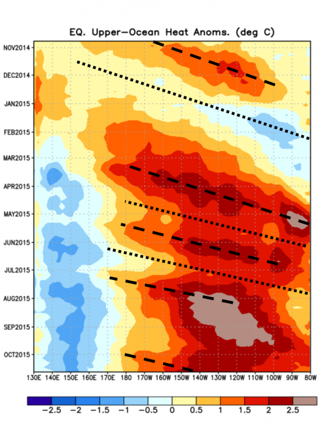
Just for reference from the last two super Ninos. Edit to add 2015 specifically as I do not have 1997.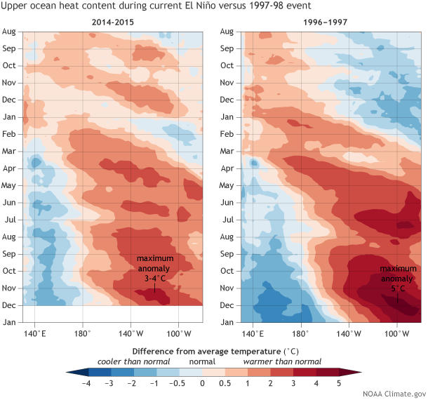
-
El Nino 2023-2024
so_whats_happening replied to George001's topic in Weather Forecasting and Discussion
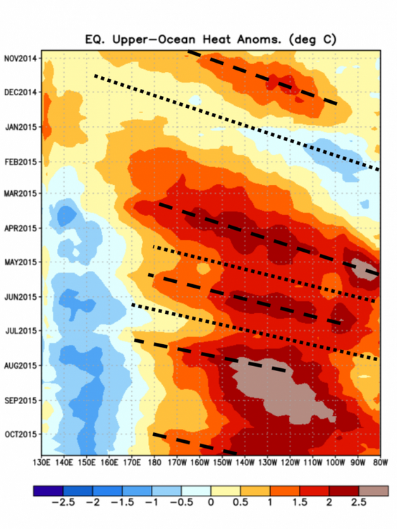
So here was the large WWB event from the mid to end of May we saw the effects in about 2 weeks start to be noticeable in the subsurface configuration after the WWB took place. So far this one was a bit further east than the one that took place mid to late May. About the same magnitude but also had easterly progression from an event in May around 90-100E. This is typically how I see a WWB going to help relocate warmer waters further east and allow subsequent cooling to occur in its wake. This probably was the stepping stone to where we are with getting the +IOD to form as well as the final nudge in August which was an even slightly further east WWB event. Mind you nothing has stirred up east of the dateline to date but the weakening of trades definitely spread across Nino regions from not only the WPAC WWB but a minor EPAC WWB working in tandem. Now it is possible we see something in similar fashion take place but with yet again further east placement of this new WWB. Although again I am unsure what a west propagating WWB means in warming ( guess we will find out) overall though OHC in the 100-180 region didn't move all that much even with the large WWB event in May and August. Can also do one leading up to August and past the August event if folks are interested. This alone is the reason I do see us going to +2C for a bit but I do not for see it sustaining itself long let alone getting much above that as we move forward. Again I only see the warmth maybe lasting a month at best and that may be giving it more credit than I should. -
El Nino 2023-2024
so_whats_happening replied to George001's topic in Weather Forecasting and Discussion
September and October I believe will end up about the same as far as monthly means go. As for peak I do not believe this has occurred yet. I still do see about a months worth of floating around 2C this will help nudge the ONI up but still be below that 2C trimonthly that has been floating around for sometime. OND peak is likely and we will have to wait and see what happens after we get into November, but if we continue on the path we have there is about a 2-2.5 month difference in between large WWB events over the entire life of this Nino. This would put another around early January which would most likely just help drag out the Nino instead of it collapsing but that is to be determined. I personally feel this is the last solid push we will see with this Nino event so it better be a big one to get even remotely close to a super trimonthly average. -
El Nino 2023-2024
so_whats_happening replied to George001's topic in Weather Forecasting and Discussion
Been trying to remember to save these as well since it shows a broader look of the Pacific. -
El Nino 2023-2024
so_whats_happening replied to George001's topic in Weather Forecasting and Discussion
Very cool to see the bounce between the 2 hemispheres given fairly similar situations, only thing is we have a stronger nino this year. Can i find this on BOM website?