lakeeffectkid383
-
Posts
5,059 -
Joined
-
Last visited
Content Type
Profiles
Blogs
Forums
American Weather
Media Demo
Store
Gallery
Everything posted by lakeeffectkid383
-

Upstate/Eastern New York-Into Winter!
lakeeffectkid383 replied to BuffaloWeather's topic in Upstate New York/Pennsylvania
Thank god a I got a foot in 2 days earlier this month or I’d be ready to jump off a cliff the way this winter has gone and is going so far. What an absolute horrid start to winter for anybody outside very localized lake effect areas. What the hell has happened to winters as we knew them? This crap is a total joke, it’s like we live in the Mid Atlantic. -
Upstate/Eastern New York-Into Winter!
lakeeffectkid383 replied to BuffaloWeather's topic in Upstate New York/Pennsylvania
Looked outside and have moderate snow with TINY flakes however grass has a nice coating on it despite next to nothing on radar what so ever.
-
Upstate/Eastern New York-Into Winter!
lakeeffectkid383 replied to BuffaloWeather's topic in Upstate New York/Pennsylvania
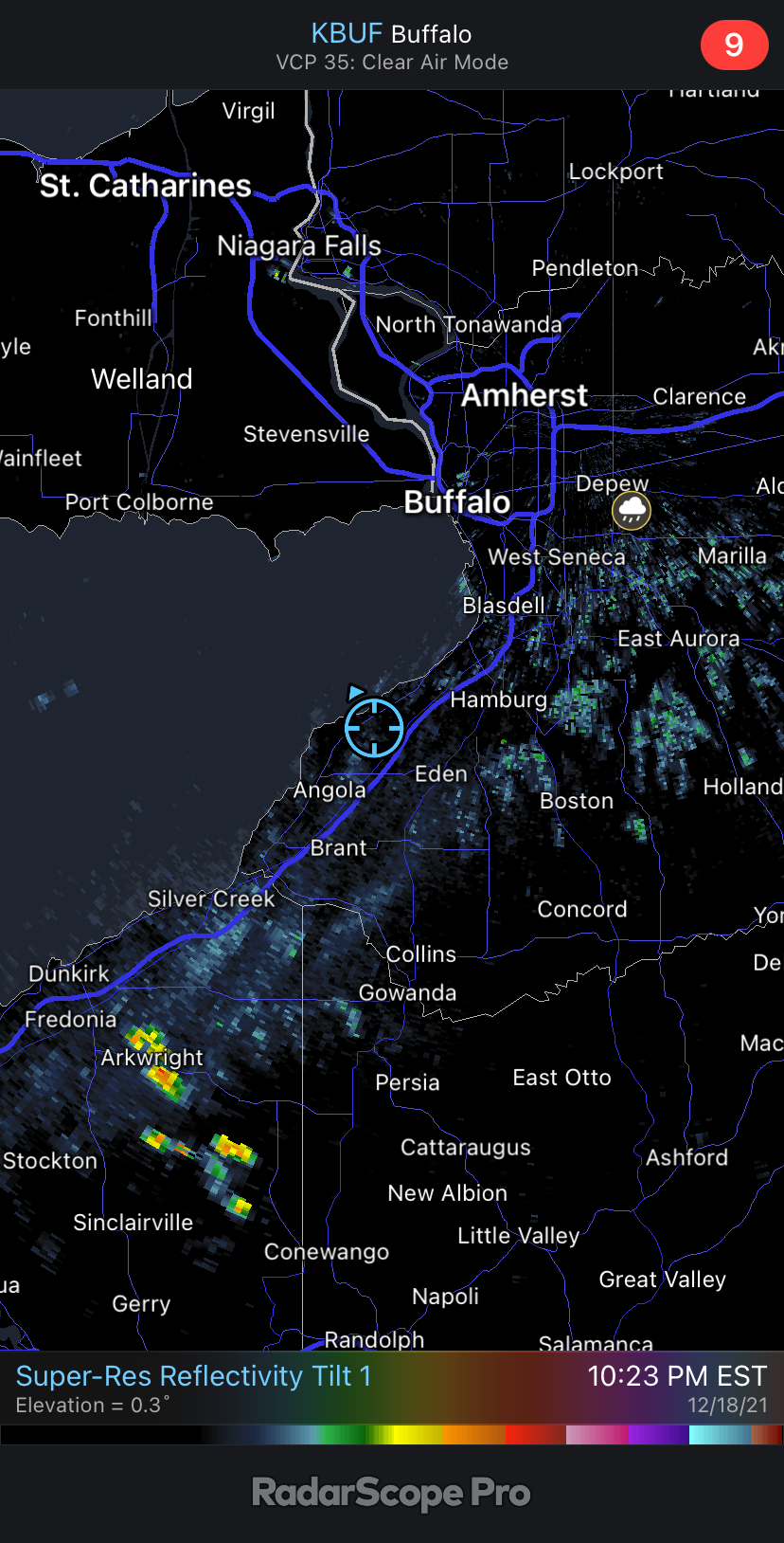
In Cheektowaga between Union and Transit and was moderate snow with huge flakes 15 minutes ago now mixing heavily with sleet and tiny flakes. Changeover is racing north now. -
Upstate/Eastern New York-Into Winter!
lakeeffectkid383 replied to BuffaloWeather's topic in Upstate New York/Pennsylvania
Precip has just began here. Already a mix of sleet and plain rain at 34 degrees. Not a good sign for you folks up north. -
Upstate/Eastern New York-Into Winter!
lakeeffectkid383 replied to BuffaloWeather's topic in Upstate New York/Pennsylvania
Winds have just ramped up like crazy out of nowhere. House shaking gust. I would bet at least 55 mph. Right behind that little squall line. -
Upstate/Eastern New York-Into Winter!
lakeeffectkid383 replied to BuffaloWeather's topic in Upstate New York/Pennsylvania
I’m expecting nothing more then a half hour of snow switching over to sleet and then quickly to rain. Not expecting anymore then a dusting that will be gone within an hour after the changeover. Just not a good setup for us on the lake plain south of BUF. -
Upstate/Eastern New York-Into Winter!
lakeeffectkid383 replied to BuffaloWeather's topic in Upstate New York/Pennsylvania
I’ll believe it when I see it. I’m going 75 with a passing rain shower. -
Upstate/Eastern New York-Into Winter!
lakeeffectkid383 replied to BuffaloWeather's topic in Upstate New York/Pennsylvania
Water level subsiding now. Back down to 10 ft and falling. Winds have definitley began to calm here -
Upstate/Eastern New York-Into Winter!
lakeeffectkid383 replied to BuffaloWeather's topic in Upstate New York/Pennsylvania
Mother in law with my other 2 kids at home in Derby just lost power. Said she’s never heard wind like this in her entire life and she’s 65 years old. -
Upstate/Eastern New York-Into Winter!
lakeeffectkid383 replied to BuffaloWeather's topic in Upstate New York/Pennsylvania
116” above low water datum and rising rapidly still. That’s nearly 10 feet and nearly 2 feet above floor stage. -
Upstate/Eastern New York-Into Winter!
lakeeffectkid383 replied to BuffaloWeather's topic in Upstate New York/Pennsylvania
Buffalo or Rochester ? -
Upstate/Eastern New York-Into Winter!
lakeeffectkid383 replied to BuffaloWeather's topic in Upstate New York/Pennsylvania
Winds with that stuff is super weak. 30mph or less. -
Upstate/Eastern New York-Into Winter!
lakeeffectkid383 replied to BuffaloWeather's topic in Upstate New York/Pennsylvania
Woah full sunshine here now. -
Upstate/Eastern New York-Into Winter!
lakeeffectkid383 replied to BuffaloWeather's topic in Upstate New York/Pennsylvania
Strongest gust so far ? Doesn’t look all that impressive from up top. Trees don’t look to even be swaying all that much.? -
Upstate/Eastern New York-Into Winter!
lakeeffectkid383 replied to BuffaloWeather's topic in Upstate New York/Pennsylvania
Just remember they’re getting the timing better with peak daytime heating and mixing when the fronts moving through, ours will be closer to sunset although they don’t have a huge funnel to the SW to enhance the winds either. I like your call of gust near 75 for BUF. -
Upstate/Eastern New York-Into Winter!
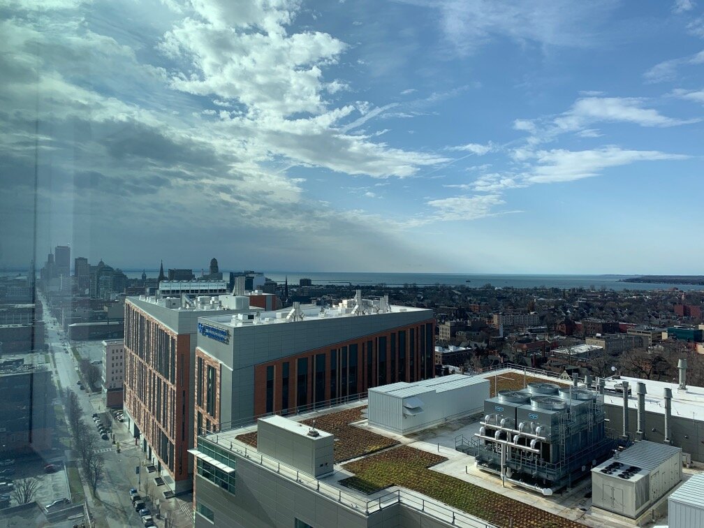
lakeeffectkid383 replied to BuffaloWeather's topic in Upstate New York/Pennsylvania
FULL sunshine in downtown Buffalo right now. I’m actually watching this from the 12th floor of Oshei children’s hospital as my daughter is sick and was admitted last night.
-
Upstate/Eastern New York-Into Winter!
lakeeffectkid383 replied to BuffaloWeather's topic in Upstate New York/Pennsylvania
Does this also bode well for a little bit more mixing if we can get the front through here while we still have some daylight? -
Upstate/Eastern New York-Into Winter!
lakeeffectkid383 replied to BuffaloWeather's topic in Upstate New York/Pennsylvania
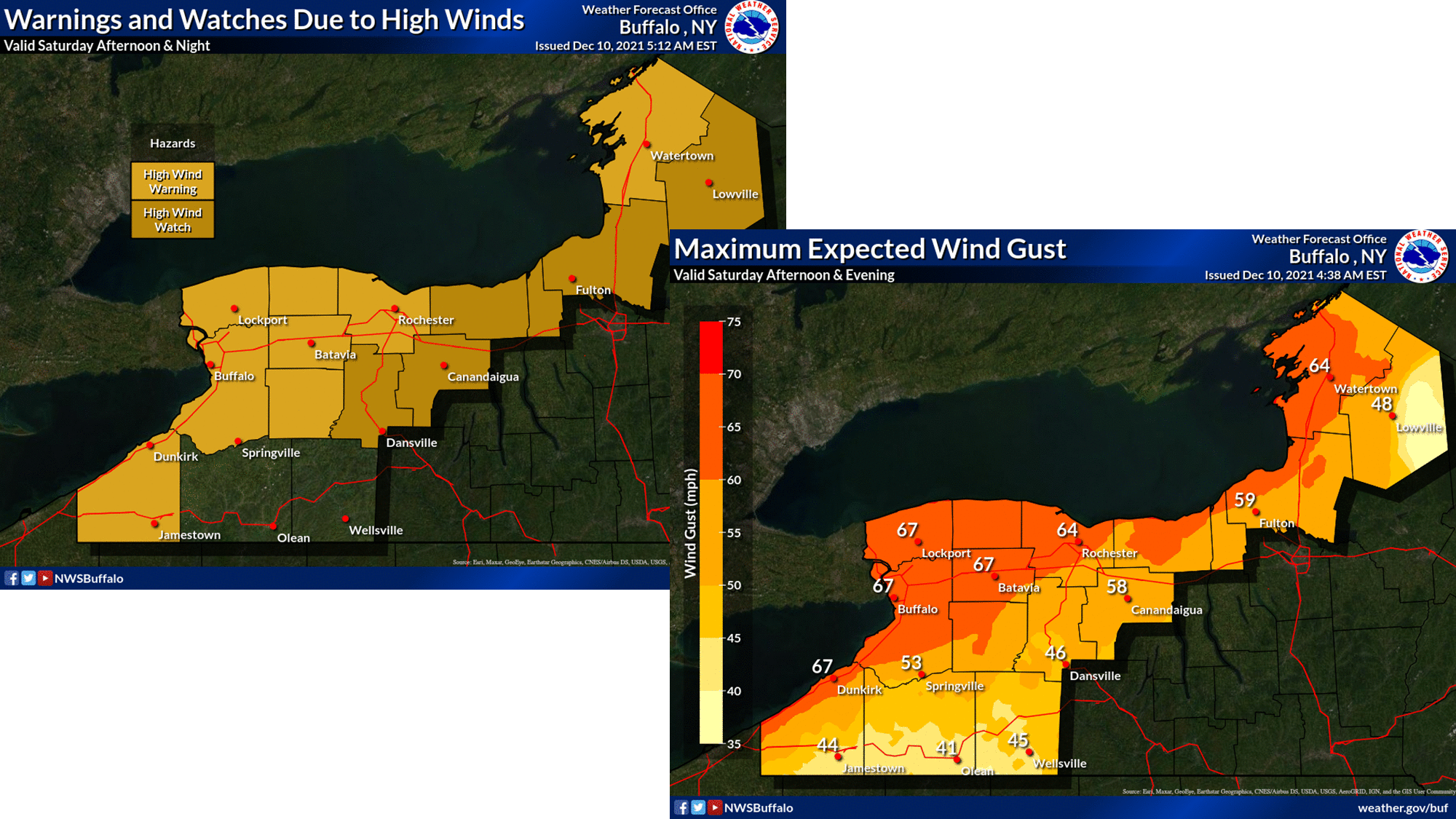
Dude winds are already sustained at 31 gusting to 45 at BUF , wth?? There’s already a constant low roar here in Derby and the front is 6-8 hours away. Have a gut feeling we’re going to be seeing some 70+ mph gust on the Niagara Frontier today. -
Upstate/Eastern New York-Into Winter!
lakeeffectkid383 replied to BuffaloWeather's topic in Upstate New York/Pennsylvania
NWS has wind gust to 64 Kt at Buffalo Saturday afternoon. That’s 73 mph. Yeesh! -
Upstate/Eastern New York-Into Winter!
lakeeffectkid383 replied to BuffaloWeather's topic in Upstate New York/Pennsylvania
High Wind Warning now, gust to 70 mph. Seems like the real deal.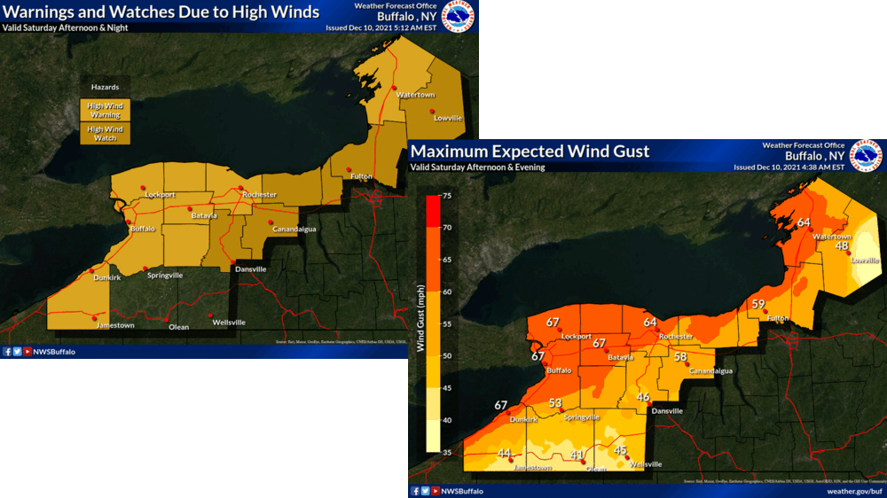
-
Upstate/Eastern New York-Into Winter!
lakeeffectkid383 replied to BuffaloWeather's topic in Upstate New York/Pennsylvania
Finished with 3.9” in Derby. 12.4” since yesterday afternoon. 18.8” on the season. What a wonderful surprise last 28 hours or so. Looks like mid winter (till Saturday haha). -
Upstate/Eastern New York-Into Winter!
lakeeffectkid383 replied to BuffaloWeather's topic in Upstate New York/Pennsylvania
Still snowing here. 3.6” here as well. 12.1” since yesterday afternoon. -
Upstate/Eastern New York-Into Winter!
lakeeffectkid383 replied to BuffaloWeather's topic in Upstate New York/Pennsylvania
Snowing 2-3” an hour. Awesomeness. Snowing harder then it did all last night. -
Upstate/Eastern New York-Into Winter!
lakeeffectkid383 replied to BuffaloWeather's topic in Upstate New York/Pennsylvania
Finished with an additional .8 “ here so storm total is 8.5” . Warning criteria when there was nothing posted at the start of the event. -
Upstate/Eastern New York-Into Winter!
lakeeffectkid383 replied to BuffaloWeather's topic in Upstate New York/Pennsylvania
They just fixed it. Issued a new one. nformation Statement National Weather Service Buffalo NY 1139 PM EST Tue Dec 7 2021 ...SNOWFALL REPORTS (CORRECTED)... Corrected the location of the 7.7 inch snowfall report which occurred 4 NW Eden and not 2 WNW West Seneca. Location Amount Time/Date Lat/Lon/Elev (ft.) ...New York... ...Erie County... 4 NW Eden 7.7 in 1041 PM 12/07 42.69N/78.97W 3 SE West Seneca 1.1 in 0715 PM 12/07 42.81N/78.71W Springville 5NE 0.7 in 0700 PM 12/07 42.55N/78.58W/1694 ...Monroe County... Webster 2NE 0.1 in 0800 PM 12/07 43.24N/77.39W/275 3 SSE Gates-North Gates 0.1 in 0700 PM 12/07 43.12N/77.67W &&