lakeeffectkid383
-
Posts
5,059 -
Joined
-
Last visited
Content Type
Profiles
Blogs
Forums
American Weather
Media Demo
Store
Gallery
Everything posted by lakeeffectkid383
-

Upstate/Eastern New York-Into Winter!
lakeeffectkid383 replied to BuffaloWeather's topic in Upstate New York/Pennsylvania
Just measured 1.6” here. -
Upstate/Eastern New York-Into Winter!
lakeeffectkid383 replied to BuffaloWeather's topic in Upstate New York/Pennsylvania
I just drove home from running around this morning. From Walmart on Southwestern all the way to my house it was snowing 1”hr easily with snow full on covering the road, close to 2” on the main roads. Not one plow or salt truck as all and roads were absolutely horrendous. At times it was snowing so hard there were multiple people driving 15-20 mph on Southwestern with their hazard lights on. Multiple spin outs and accidents along my route home. Close to 2” here as well as can barely see the grass. -
Upstate/Eastern New York-Into Winter!
lakeeffectkid383 replied to BuffaloWeather's topic in Upstate New York/Pennsylvania
Dude legit 1-1/2” hr rates right now and sticking too. -
Upstate/Eastern New York-Into Winter!
lakeeffectkid383 replied to BuffaloWeather's topic in Upstate New York/Pennsylvania
Lol haha thats the game I really said Josh Allen is the guy haha. As for my house only 0.2” of snow in Derby but it is beginning to pick back up. Was more of a rain/really wet snow mix this morning while areas to the north were snow. Even going to Walmart in Hamburg there is noticeably more snow than at my house. -
Upstate/Eastern New York-Into Winter!
lakeeffectkid383 replied to BuffaloWeather's topic in Upstate New York/Pennsylvania
1.7” near OP/WS border at Tops/Lowe’s Plaza. -
Upstate/Eastern New York-Into Winter!
lakeeffectkid383 replied to BuffaloWeather's topic in Upstate New York/Pennsylvania
Had some more moderate rain mixed with graupel. Had some thunder and lightning around 11 as well. -
Upstate/Eastern New York-Into Winter!
lakeeffectkid383 replied to BuffaloWeather's topic in Upstate New York/Pennsylvania
I just had the same here. Seemed more like hail to me the way it was bouncing off the cars, graupel is usually soft and doesn’t make as much noise. However VIL data on the radar doesn’t show anything so not sure about hail. -
Upstate/Eastern New York-Into Winter!
lakeeffectkid383 replied to BuffaloWeather's topic in Upstate New York/Pennsylvania
That is a textbook look. -
Upstate/Eastern New York-Into Winter!
lakeeffectkid383 replied to BuffaloWeather's topic in Upstate New York/Pennsylvania
Weak sauce. Wake me up when we have a legit chance at 6”+. -
Upstate/Eastern New York-Into Winter!
lakeeffectkid383 replied to BuffaloWeather's topic in Upstate New York/Pennsylvania
The 12z GFS looks somewhat worse for lake effect just doesn’t have as cold of temps and less moisture with winds veering WSW and then even W more quickly. Thinking this is going to be some lake effect rain/mix at lower elevations with maybe some accumulating snow over the higher elevations south of BUF as winds shift more WSW and W and boundary layer temps drop Saturday night but not expecting much at my place or any of the lower elevations as of now. Still far out and things can obviously change for the better (or worse) as we’re still not even in the range of the mesoscale models but just a step in the wrong direction IMO. -
Upstate/Eastern New York-Into Winter!
lakeeffectkid383 replied to BuffaloWeather's topic in Upstate New York/Pennsylvania
Used to go to Colden tubing (at kissing bridge) all the time. It was an absolute blast with a great lodge at the bottom to warm up and get hot chocolate and sit by a fire. Had a lift to bring you back up to the top so you didn’t even have to walk. Unfortunately they closed for good about 5 years ago and I’m not sure of any other places like that. -
Upstate/Eastern New York-Into Winter!
lakeeffectkid383 replied to BuffaloWeather's topic in Upstate New York/Pennsylvania
Making my call early T-36” this weekend. Book it. -
Upstate/Eastern New York-Into Winter!
lakeeffectkid383 replied to BuffaloWeather's topic in Upstate New York/Pennsylvania
Did the exact same thing lol haha. Didn’t even watch the game yesterday I was so busy doing everything outside, I’m so lucky I didn’t watch it because I would have been cursing at the TV left and right they way they played and lost to a Jaguar team that hadn’t won a game on US soil in over a year. -
Upstate/Eastern New York-Into Winter!
lakeeffectkid383 replied to BuffaloWeather's topic in Upstate New York/Pennsylvania
Nice stat. Let’s get an above average Nov and keep it rocking all the way through March. -
Upstate/Eastern New York-Into Winter!
lakeeffectkid383 replied to BuffaloWeather's topic in Upstate New York/Pennsylvania
Wow so far more than Lowville. Didn’t realize you averaged that much. That’s an absolutely awesome average. To average 160-180” here you would have to move to the hilltops of Boston/Colden/Holland. I’m excited to average over 100” now at around 120” compared to about 80” in Amherst. Snow retention will still be pretty lousy at my place though with only 720 feet of elevation. Once you get up into the Boston hills the retention is so much better with temps usually a few degrees cooler just due to elevation gain and then there’s obviously no downsloping like we see really bad from West Seneca to Dunkirk/Fredonia to Westfield anytime there’s a S/SE wind during winter. -
Upstate/Eastern New York-Into Winter!
lakeeffectkid383 replied to BuffaloWeather's topic in Upstate New York/Pennsylvania
Can also drive 15 minutes up rt 177 from Lowville and be in Barnes Corners where there is sometimes 2-3x as much as in Lowville in such a short drive. -
Upstate/Eastern New York-Into Winter!
lakeeffectkid383 replied to BuffaloWeather's topic in Upstate New York/Pennsylvania
Looks like Pulaski is around 133” a year according to NWS so roughly the same as Lowville. Would have to think Lowville has much better snow retention though. -
Upstate/Eastern New York-Into Winter!
lakeeffectkid383 replied to BuffaloWeather's topic in Upstate New York/Pennsylvania
December 1-3 2010 where 40”+ fell from SB and WS to Depew is exactly the type of storm I am thinking of this year for the big event to finally hit the metro. Move that band 5-7 miles north of where that band set up and have those amounts fall over downtown out to southern Amherst, Cheektowaga, and southern Clarence/Williamsville. -
Upstate/Eastern New York-Into Winter!
lakeeffectkid383 replied to BuffaloWeather's topic in Upstate New York/Pennsylvania
Yep and Dec 2013 was lake effect snow event after lake effect snow event. Had 6 events during the month of December alone… Colden saw almost 100” in December 2013 alone at 91.8”. Perrysburg had over 117” in that month alone as well. where’s the dotted line for another month like that. Lol. -
Upstate/Eastern New York-Into Winter!
lakeeffectkid383 replied to BuffaloWeather's topic in Upstate New York/Pennsylvania
First post of WIVB weather blog was Nov 2007.
-
Upstate/Eastern New York-Into Winter!
lakeeffectkid383 replied to BuffaloWeather's topic in Upstate New York/Pennsylvania
Yep been 15 years years since I started posting on the WIVB blog lol. Started on the weather forums back at Eastern Wx in Jan of 07. Man were all getting old haha. There was way too much drama on a dang weather blog back then but I guess none of us had anything better to do and there wasn’t really social media like there is today where all weather weenies can post and talk about whatever they want whenever they want freely without any consequence or ridicule. I love this forum as it’s the perfect mix of realism, optimism, and pessimism (TugHillMatt below average snow, above average temps at SYR). No one takes anything to serious but it’s not a total joke. Great place to read learn and converse about weather, sports, and other random topics. -
Upstate/Eastern New York-Into Winter!
lakeeffectkid383 replied to BuffaloWeather's topic in Upstate New York/Pennsylvania
That was more 06-09 haha. -
Upstate/Eastern New York-Into Winter!
lakeeffectkid383 replied to BuffaloWeather's topic in Upstate New York/Pennsylvania
Wish I could give this post 100 likes and lmao emojis haha. -
Upstate/Eastern New York-Into Winter!
lakeeffectkid383 replied to BuffaloWeather's topic in Upstate New York/Pennsylvania
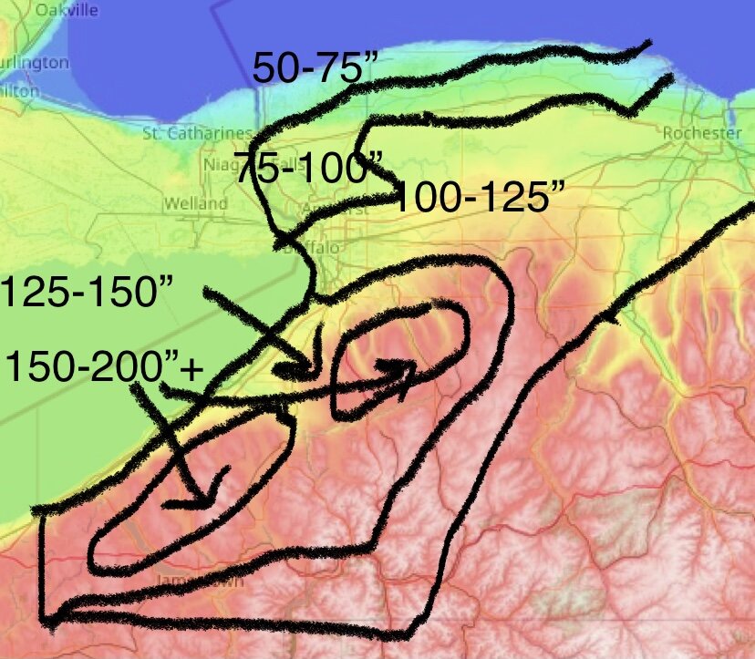
Yeah used to be a lot better a decade ago when I had a lot of free time haha. Now I barely have 5 minutes not working or taking care of a kid. Threw this together in about 6 minutes hahaha. -
Upstate/Eastern New York-Into Winter!
lakeeffectkid383 replied to BuffaloWeather's topic in Upstate New York/Pennsylvania
I’m going with 113” at KBUF for my first call. I’m thinking we get one big lake effect event (24”+) for the metro finally this year either the last 2 weeks of November or first 2 weeks of December. Think the Southtowns see a huge lake effect event sometime in mid-late January before the lake really freezes up with 3-4 feet plus from Hamburg/OP down through Boston/Colden ala Feb 2007 only a few weeks earlier.