The Iceman
-
Posts
12,313 -
Joined
-
Last visited
Content Type
Profiles
Blogs
Forums
American Weather
Media Demo
Store
Gallery
Everything posted by The Iceman
-

E PA/NJ/DE Spring 2026 Obs/Discussion
The Iceman replied to PhiEaglesfan712's topic in Philadelphia Region
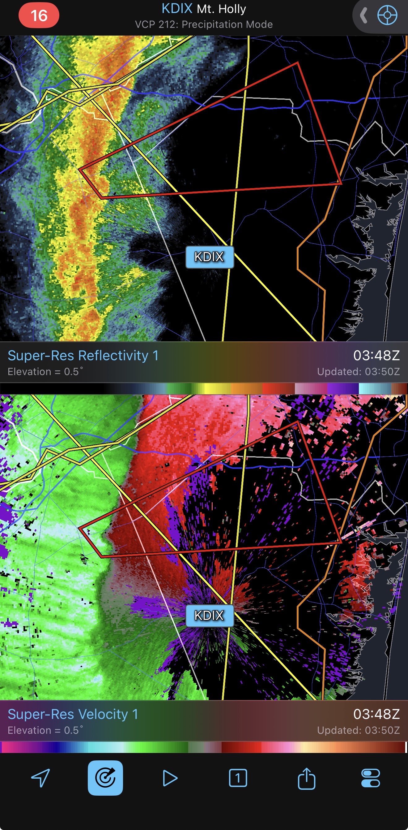
I just want to add to the conversation over yesterday’s event and the very poor job of messaging for this event. Tornado watches were cancelled by 6 pm so he had thought he was in the clear and ended up getting caught out in that awful squall line because he and many others out last night other assumed the worst was over. I have no idea why we didn’t transfer into a severe thunderstorm watch. SPC did a terrible job all around yesterday imo they overplayed the tornado threat and downplayed the wind threat after the tornado threat failed. NWS did great getting the warnings out in a timely matter but I still think people were not anticipating the strength of that line last night. -
E PA/NJ/DE Spring 2026 Obs/Discussion
The Iceman replied to PhiEaglesfan712's topic in Philadelphia Region
RIP he went back to the easternwx days maybe further.. Always such a respectful poster. -
E PA/NJ/DE Spring 2026 Obs/Discussion
The Iceman replied to PhiEaglesfan712's topic in Philadelphia Region
My buddy texted me that he was driving home from Hatfield Ice and that there’s tons of tree damage and debris in the roadways across central and lower bucks. -
E PA/NJ/DE Spring 2026 Obs/Discussion
The Iceman replied to PhiEaglesfan712's topic in Philadelphia Region
TTN gusted to 58, I was going to guess at least 60 mph winds here. -
E PA/NJ/DE Spring 2026 Obs/Discussion
The Iceman replied to PhiEaglesfan712's topic in Philadelphia Region
Tornado warning! Couplet went right over McGuire Air Force base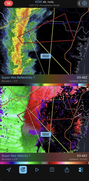
-
E PA/NJ/DE Spring 2026 Obs/Discussion
The Iceman replied to PhiEaglesfan712's topic in Philadelphia Region
Temp already down to 49F , we were at 61 before the squall. -
E PA/NJ/DE Spring 2026 Obs/Discussion
The Iceman replied to PhiEaglesfan712's topic in Philadelphia Region
That squall line really delivered wow. Crazy winds associated with it, can’t ever remember seeing flashes in the distance from transformers blowing. You could hear the roar of the wind too before it was on top of us. Reminded me of the derecho a few years ago just without the lightning. Can’t believe we still have power -
E PA/NJ/DE Spring 2026 Obs/Discussion
The Iceman replied to PhiEaglesfan712's topic in Philadelphia Region
Hey SPC if you’re looking to replace the jabroni’s that blew it today, I’m available anyway getting another soaking rain at the very least, most of the area should finish over an inch qpf. This month has delivered on the moisture so far. -
E PA/NJ/DE Spring 2026 Obs/Discussion
The Iceman replied to PhiEaglesfan712's topic in Philadelphia Region
It is for me -
E PA/NJ/DE Spring 2026 Obs/Discussion
The Iceman replied to PhiEaglesfan712's topic in Philadelphia Region
yeah the hype for today has been unbelievable, you'd think the 1974 super outbreak was happening... I have family scattered all around the east coast and all of them have been asking me what's going on with the tornado outbreak. I understand preparing the public to be storm aware but closing schools and stuff is so silly... -
E PA/NJ/DE Spring 2026 Obs/Discussion
The Iceman replied to PhiEaglesfan712's topic in Philadelphia Region
Had a few tropical downpours in the last hour with more downstream, severe threat looks DOA but should be a good gully wash at least. -
E PA/NJ/DE Spring 2026 Obs/Discussion
The Iceman replied to PhiEaglesfan712's topic in Philadelphia Region
60% of 2 or more tornado's, 30% EF 2 or stronger. 80% wind probs. -
E PA/NJ/DE Spring 2026 Obs/Discussion
The Iceman replied to PhiEaglesfan712's topic in Philadelphia Region
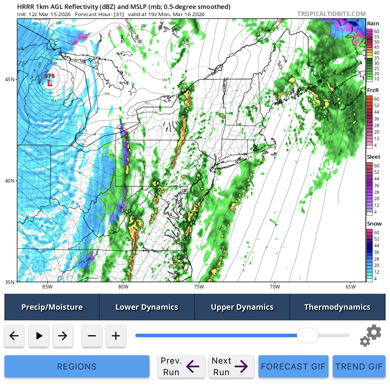
I would be surprised if we see widespread severe now. The stuff from last night is beginning to re intensify and is likely going to come into our area early this afternoon but there just isn't going to be instability in place. The best dynamics are in place after that but this afternoon stuff is going to sap all the instability and moisture. Maybe some gusty winds still with the front passing through but it continues to look less and less interesting here. Will still be a significant temp drop at least. -
E PA/NJ/DE Spring 2026 Obs/Discussion
The Iceman replied to PhiEaglesfan712's topic in Philadelphia Region
See SEPA is totally screwed severe wise if the HRRR is right, this crap at 18z tomorrow basically ruins the entire threat, dc into central pa though look under the gun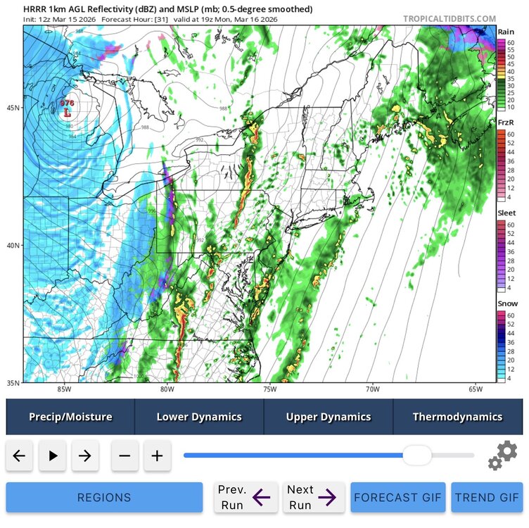
-
E PA/NJ/DE Spring 2026 Obs/Discussion
The Iceman replied to PhiEaglesfan712's topic in Philadelphia Region
Ehhh overnight runs shifted the threat more towards Lehigh valley and Lancaster for our area. Some of the meso’s now are bringing a lot of crapvection throughout the day and the QLCS breaks up and weakens as it approaches SE PA with zero instability. Mid Atlantic/DC area looks primed for a tornado outbreak though. It’s going to come down if the QLCS line can hold together or not for us. That change and slightly later timing though has made this less exciting than yesterday for se pa imo -
E PA/NJ/DE Spring 2026 Obs/Discussion
The Iceman replied to PhiEaglesfan712's topic in Philadelphia Region
I just looked at the 12z guidance and timing really couldn’t be better for our area but especially for Lancaster and Lehigh valley I think we see the wind probs expanded NE next update. One of the better looking march severe threats I can remember and yes totally agree discrete supercells are not out of the picture. Also I think some places will end as snow as well. Monday afternoon and evening should be exciting. Gear up the generators especially with the wet conditions of late. edit: holy shit at the euro… it argues for a discrete threat ahead of the qlcs in the early afternoon. Ominous look. -
We have no mods, party it up! I remember you from way back, welcome to Philly!
-
E PA/NJ/DE Spring 2026 Obs/Discussion
The Iceman replied to PhiEaglesfan712's topic in Philadelphia Region
Said it a few days ago, but blocking signal for April is pretty strong at least the first half imo Problem is that late it really doesn’t matter at the coast. I think SNE or NNE is going to get smoked late month or early April though. Should make for a cool dreary first half of April for us. -
E PA/NJ/DE Spring 2026 Obs/Discussion
The Iceman replied to PhiEaglesfan712's topic in Philadelphia Region
Only Redsky can complain about seeing snow a day after it was 80… dude could live in Kamchatka and he’d find a way to complain about only seeing 10 feet while the town next to him got 11 feet. -
E PA/NJ/DE Spring 2026 Obs/Discussion
The Iceman replied to PhiEaglesfan712's topic in Philadelphia Region
Buddy I love winter more than 99% of this board but in my opinion she largely dead for our areas at this junction… I always do appreciate your optimism though, let’s do an April snow this year if it’s going to be dreary anyway. -
Dude confidently in our subforum posted 10 days before our coldest January in a decade that it’d be above average by the end of the month… Then proceeded to cancel winter before our largest snow of the year… Oh yeah and said it’d be 70 by march 1st(it was in the 40s). After all that you kind of just know it’s safe to say you don’t have to take him serious and you’d think he’d learn not to make definitive statements… he’s going to be on the warm/snowless side of things no matter what. It’s a shame because he does actually have some knowledge… good luck to you guys today!
-
E PA/NJ/DE Spring 2026 Obs/Discussion
The Iceman replied to PhiEaglesfan712's topic in Philadelphia Region
06z guidance backed way the hell off as I guess it finally realized A. It was 80 yesterday and b. This wraparound/anafront shit is largely a mirage like always… I'm with @MacChump , it’s porch weather season now -
E PA/NJ/DE Spring 2026 Obs/Discussion
The Iceman replied to PhiEaglesfan712's topic in Philadelphia Region
long range forecast based on the GEFS/EPS, cool down next week then I see another warm up towards the end of the month before a cool and dreary april. Heights start to build over Scandy late month and retro towards greenland by the end of March. April is at least going to start blocky imo. -
E PA/NJ/DE Spring 2026 Obs/Discussion
The Iceman replied to PhiEaglesfan712's topic in Philadelphia Region
the wrf-arw and arw2 both show it too... me personally I think it's cracked out. we'll see though. Would be pretty cool just to see flakes after it being 80 today. -
E PA/NJ/DE Spring 2026 Obs/Discussion
The Iceman replied to PhiEaglesfan712's topic in Philadelphia Region
timing is bad for most of the area imo, area's out west might get some wind damage though